I started wondering about other variables that might affect pavement condition index (PCI) in the council districts, so here is a little more exploration. See the previous post: pavement condition in Sac City.
First, the council district map, for those who may not be familiar with boundaries.
I wondered about the relationship between population density (people per square mile) and PCI. There isn’t any correlation, though again, the district 1 and 8 outliers may be interesting. I did not realize that district 8 has the highest population density of the districts.
I wondered about the relationship between lanes miles and PCI. There is a weak correlation.
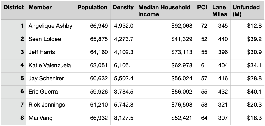
And finally, here is my current data table, in case you want to play with data or suggest insights. Note that the population of each district is roughly the same, as it should be. The unfunded column is the amount (millions of dollars) of backlog, to bring roadways up to PCI 75, but it does not include the ongoing yearly expense of maintaining them at that level.
In the search for other information, I came across the City of Sacramento Pavement Condition Report, dated March 2020, and it has some interesting things to ponder. The city has 3000 lane miles of streets. The county reports road miles instead of lane miles, so I can’t directly compare the city and county, but the city does say it has the fifth largest roadways network in California.
The report has maps for each council district, showing the PCI for each (PCI = pavement condition index, a measure of how well the roadway has been maintained, higher is better). I wondered whether the PCI correlated with income, as many things do, so I plotted 2020 median household income of each district against PCI, table and chart below.
There is not a strong correlation between income and PCI, R = .42, but district 1 and 2 are clear outliers, with 1 being the highest income and highest PCI, and 2 being the lowest income and lowest PCI. The city report says that the reason district 1 has a high PCI is that the roads there are newer, but I’m a little doubtful this explains it all, since many of the roads in that area are now old enough to need maintenance.
The target score for ‘roads in good condition’ is at least PCI 75, so Sacramento is falling far short of that because it is not spending enough on roadway maintenance. Part of the reason for this is that money is spent on building new roadways and widening roadways instead of maintaining roadways. But the underlying reason is that the city has allowed to be constructed, and then taken on maintenance responsibility for, roadways which it does not have the income to maintain. In new developments, construction of internal roadways is paid by the developer, but arterials and collectors, which often must be upgraded to handle increased traffic, and the interchanges with freeways, are largely paid by the city, or grants, and are maintained by the city. But low density development, of which the city was formerly very fond and still has some attachment to, cannot ever generate enough income in property or sales taxes to maintain the roadways. This is one of the great suburban subsidies that so hurts our cities and counties.
The report lays out three funding level scenarios:
current funding levels: The PCI will deteriorate over 10 years to 42, which is rated ‘poor’, and if ever corrected, would cost about ten times as much to correct as it would to maintain. I doubt that most people in the city would find this in any way acceptable.
maintain current conditions: To keep the PCI level at 60, the city would need to spend $35.7 million per year, but it is currently only spending $9.7 million per year. This is 3.7 times current expenditures. Though the PCI would be stable, there would be a continuous increasing backlog of maintenance because the PCI would not be improved to the desired 75.
improve conditions to state of good repair: To bring PCI to 75 would cost $58.5 million per year. This is 6.0 times current expenditures.
What to do? I’m sure if the city knew, it might never have gotten into this bind. This is a pattern with nearly all cities, that they cannot under any reasonable current taxation scheme hope to maintain their infrastructure. This post is about roadways, but the same is true of water supply and sewer and electric and gas. And services such as fire and police, for that matter. And it doesn’t even touch on the need for sidewalk maintenance, which is only addressed in terms of adding ADA structures at intersections. For much greater insight on the problem and possible solutions, I refer you to Strong Towns and the book Strong Towns: A Bottom-Up Revolution to Rebuild American Prosperity (from your local bookstore or library).
But I will suggest some things:
a moratorium on accepting any new roadways into the city, until the city has identified a mechanism for maintaining them, which would probably entail the developer paying into a trust fund for maintenance
paving of parking lanes to a lower level of maintenance than travel lanes; adjacent areas do not need the load bearing capacity of travel lanes nor receive as much wear and tear; the city has already done this in a few locations
reducing excess travel lanes; for most roadways in the city, three travel lanes per direction are excess capacity, rarely needed except for brief periods of time or in uncommon circumstances; though re-allocation to bike lanes, separated bikeways, or sidewalks (or in a few cases, parking) should be the ultimate fate of these excess areas, in the meanwhile they can just be blocked off from use and therefore remove the need for maintenance; in many cases two lanes per direction are also excess
evaluate whether a lower PCI than 75 might be just fine for residential streets and collector streets; after all, poor pavement does have a traffic calming effect, and we need traffic calming everywhere, so maybe PCI 60 is OK for many roadways
I believe that funding to maintain local streets, most of which are residential streets, and probably collector streets, should come from the city or county level, not from the state or federal government. The closer to the roadway the funding is, the more likely the city or county is to make rational and sustainable decisions about roadway maintenance responsibilities and funding. I think an argument could be made that arterial maintenance should be funded by the state since these roadways serve traffic beyond the city and county boundaries.
As a car-free person, you might assume that I don’t care much about pavement condition, but buses and bikes operate on the same streets as private motor vehicles and commercial vehicles, so acceptable pavement condition is important to me as well.
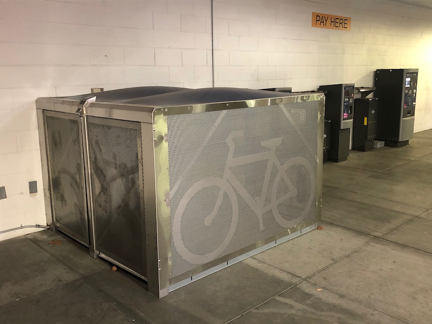
The City of Sacramento has installed some BikeLink bike storage lockers in parking garages. These are the first city-sponsored lockers, though Sacramento Valley Station (Capitol Corridor) has an extensive locker installation, Folsom has had lockers at the three light rail stations for several years, and Roseville has a few locations.
The new city locations are mostly parking garages: Memorial Garage, 805 14th St, City Hall Garage, 1000 I St, Capitol Garage, 1126 11th St, and Tower Bridge Garage, 135 Neasham Cir, with one additional location in the K St pedestrian tunnel to Old Town Sacramento/Sacramento Riverfront. I’m not overly fond of parking garage locations, as they are out of sight and not a place most bicyclists would think of to seek out bike parking, but they are certainly better than nothing, and people will eventually discover and use them.
BikeLink lockers in Sacramento Memorial Garage
I hope that the next set of BikeLink lockers in Sacramento are located centrally and visibly at high bicyclist traffic areas, for example DoCo, and the new convention center and community center. They are particularly important where bicycles will be parked for longer time periods, such as attending events, and where parking is needed at night. For short-term, day-time parking, regular bike racks will serve most users. However, employees who bike to work often do not have safe storage, I see a lot of bikes parked out behind buildings, locked to whatever can be found, and I suspect most of these are low-income employees of service businesses, who deserve better security for their bikes. So high retail locations like restaurant areas and malls should also have them, for the use of employees if not others.
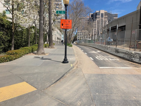
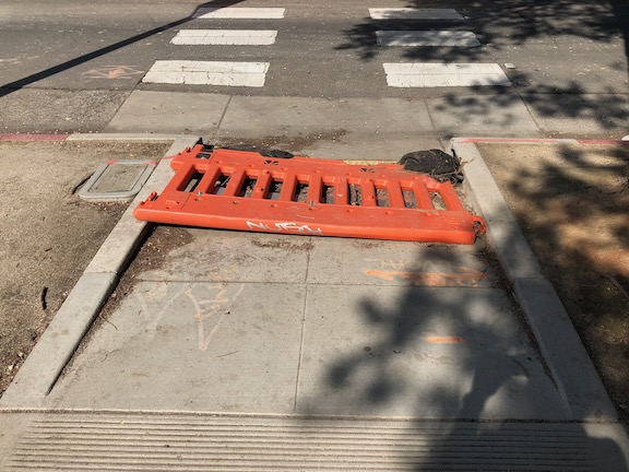
Thank you, Ali Doerr Westbrook, for flagging the latest violation of walker and bicyclist accommodation on a construction project in Sacramento.
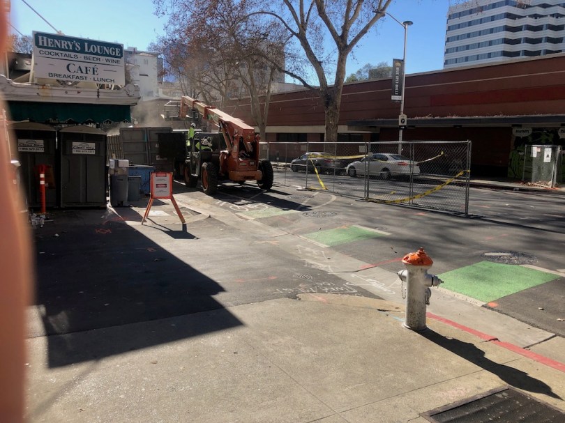
The east side of 9th St between L St and the alley is blocked by a construction project. Both the sidewalk and bike lane are blocked. There is no advance signing at 9th and K for southbound walkers and bicyclists, as required by ADA. There is no signing on the construction fencing, as required by ADA. Construction fencing is not an acceptable detectable warning, as required by ADA. Note that this construction project, the conversion of Capitol Park Hotel into supportive housing, is a city project, so not only is the city responsible for a traffic plan that accommodates walkers and bicyclists, but field checking that the plan is being followed, and enforcing it when it is not.
9th St at K St, no advance warning of closure ahead for walkers or bicyclists
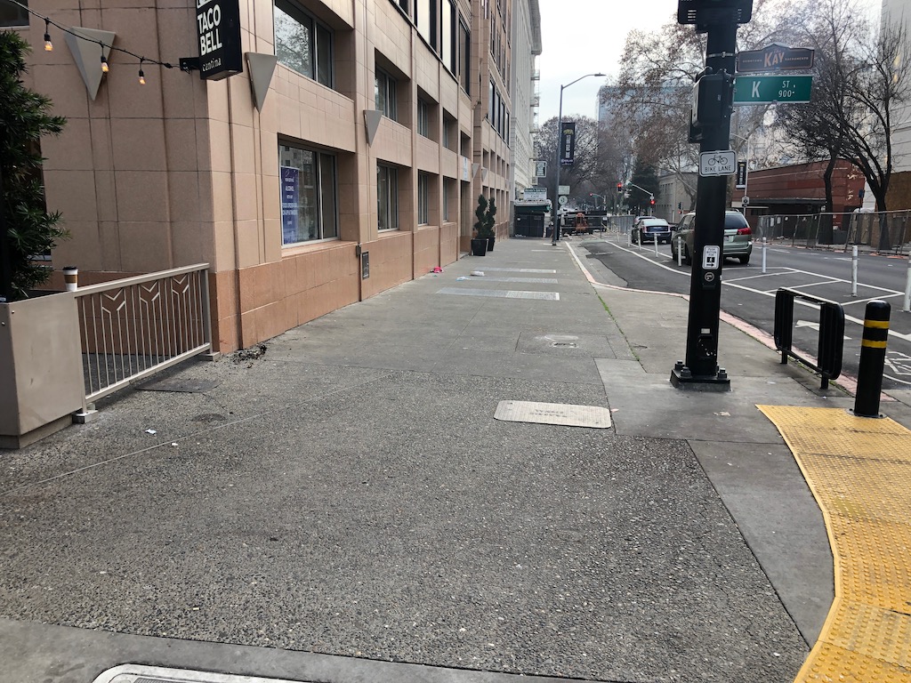
This blockage would in itself be bad, but it is made worse by the blockage of the sidewalk on the west side of 9th St, between K and the alley. This private project is also not properly signed and barricaded. Between these two projects, there is NO walker access on 9th St between K St and L St. None. None. None. Of course one could cross at the alley between one side and the other, but then the city conveniently has a walker-hostile code that crossing streets at alleys is illegal. Got the bases covered, Sacramento!
Though the most egregious, this incident is just the latest in a series of offences in the central city. I have posted on some of these here (tag: construction zone), and on Twitter. I’ve also reported a large number of them to the city’s 311 app. Of these 311 reports, about half are closed without anything being done. Making the same report multiple times increases the likelihood, but doesn’t guarantee it.
The worst of the violations are on city projects. The renewal of Memorial Auditorium had issues. Though now finished, it resulted in the permanent closure of the sidewalk on the south side of I Street. The next worse offense is the ongoing city project called 3C, the convention center and community auditorium construction project. Though some of the issues have been resolved here, several remain, particularly on the 15th St side. And this Capitol Park Hotel project is also a city project. There have been other city project problems, but I don’t have time today to go back through my records and photos to identify all of them.
In response to the concerns from myself and many others, the city had said that it would come up with a construction accommodation policy. After a year, nothing has happened. The city, at least the part of the city responsible for construction zone traffic plans, just does not care. Walkers and bicyclists are routinely ignored or actively discriminated against, in favor of motor vehicle drivers. The city is in violation of its ADA consent decree in allowing these issues to occur and to continue.
JUMP unceremoniously pulled out of Sacramento (the Sacramento region program that included West Sacramento and Davis) in the very early days of the pandemic. The bike and scooters disappeared, except for those few that are still out there, abandoned and never picked up. Though the company claimed that the devices weren’t being used, that is not true. Despite people not commuting to work (the stay at home was not yet clearly defined), they were still getting used, at perhaps half the rate as before. I’ve suspected that Uber/JUMP was already planning a pull-out, and saw the pandemic as a convenient excuse. Sacramento had been the most successful JUMP system in the US, in terms of rides per bike per day. Some argue that means they would not have pulled out unless they had to. But I see exactly the opposite reason, that they pulled the bikes and scooters because they were so successfully competing with what Uber considers (and has now demonstrated) to be its core business, ride hailing.
Lime also had scooters here for a while, but they disappeared as well. Spin had a program based on the campus of Sacramento State, and I saw a few of the scooters off campus, but they were never widespread. I’ve heard rumors of other scooter companies, but never saw any of the scooters. There were also some short-lived or planned but not implemented bike and scooter share programs in other cities around the region.
JUMP is now out of the bike and scooter business altogether. They sold the business, and apparently some of the bikes, to Lime. There are stories on the Internet from locations all around the US about Uber recycling the batteries and scrapping the bikes, so this is apparently widespread, and either already has or will shortly erase most of the bike fleet from existence.
Lime had an electric bike share bike for a while, though never in Sacramento. I saw them but never rode one, as the places they were available had alternative vendors that I was already using. The reviews I read said they were much better than the pedal bikes Lime was famous/infamous for, but nowhere near as good as JUMP bikes.
So, what does this have to do with re-opening from the pandemic? I have not heard anything from any of the agencies involved in the bike share program about how bike share can be brought back. SACOG (Sacramento Area Council of Governments), the original sponsor of the Tower Bridge pilot program (remember the white SoBi bikes?), SMAQMD (Sacramento Metropolitan Air Quality Management District), which provided some of the start-up funds, the City of Sacramento, the City of West Sacramento, and the City of Davis. Not a peep. There may be discussions going on, just not public, or there may not be.
This region, not just the area covered by the JUMP program, must have a bike share program. I am less certain that scooters must be part of the program, but I’m sure many feel they should. As people who were using transit but are not willing to right now, for an unknown but hopefully not too long period of time, search for alternatives, the choice to drive, and often to purchase a vehicle in order to drive, would be disastrous for the region. Our air quality has been wonderful for three months, but has already returned to the ‘unhealthy for sensitive individuals’ level even with only a fraction of the pre-pandemic traffic levels. If 80% of those who were using transit now drive, air quality will likely be in the ‘unhealthy’ for all category for much of the summer, and jump into the ‘very unhealthy’ category from time to time. We can’t let this happen. We must provide alternatives for people who cannot and will not drive, and that must include bike share. Of course the impact of motor vehicles, more than 40% of carbon emissions in the state, go far beyond current air quality to civilization-changing climate change, but my biggest concern right now is the short term impact on air quality.
Beyond air quality and climate, there are equity concerns about how we re-open. Yes, I know the JUMP system was not perfect. Even after expansion, it covered only part of the low income communities in Sacramento. JUMP had a low income uer discount program, but it was almost a state secret, and they never solved the issue for unbanked people.
We know that most transit users right now are essential workers and people who have no other way of getting to essential destinations. Those who can have been driving, but many can’t. They are not of a driving age (too old or too young), the have valid reasons they are unable to drive, and they simply do not want to be a part of the planet-destroying car obsession. What are we doing to do for these people? Are we going to put all our transportation eggs (funding and projects) into the cars-first basket, as we have done for too long, or are we going to change our futile ways and provide real alternatives? Are we going to commit low income people to a descending spiral of debt as they try to keep old cars running, or buy cars that barely run, just so they can get where they need to go?
The solution is bike share. Here is what I think needs to happen:
Equity concerns must be predominant in rolling out the new bike share system. Who really needs this option? How can we make sure it works for them? As one of my favorite people, Tamika Butler (and many others) has said, we don’t want to return to normal, because normal was never acceptable. High income state office workers are not the people the new system should be designed for, though certainly it should work for them too.
We must discard the idea that a privately owned and operated system can work to meet the transportation needs of the region. It could be a public system, or it could be a public/private system, but it cannot ever again be solely private.
Bike share is identified as a critical transportation service, and as a logical part of the transit system. This does not mean that it is operated by transit agencies, though it could be, but that transit agencies are a core partner in the program.
Major traffic attractors will not reopen until a bike share system is in place to handle the additional car traffic that might otherwise be generated. This most definitely includes shopping malls, and probably includes government offices in downtown Sacramento. Universities and colleges are not an issue, for now, as they will be online and not the trip generators they usually are.
Funding for bike share infrastructure (bikes and bike racks) will be diverted from road building projects. If the emergency powers of the state and county have any meaning at all, this is well within their power to do. When transportation agencies talk about the ‘color of money’, what they generally mean is that they don’t want to make the effort to justify different uses, and they are happy with the current mode share. Time to end that malfeasance.
The City of Sacramento is not taking the failures of its construction zone signing and maintenance seriously. I have forwarded a number of issues to the city, both via email and via the 311 service. Nothing seems to have come of any of this. I have not seen a single location corrected. The 311 requests are being closed without being corrected. It is not clear to me whether the city staff are incompetent, or simply don’t care, but I’m going to list some resources I’ve found useful. These may be useful to readers, so that you can recognize failures and report them as well.
The Manual of Uniform Traffic Control Devices (MUTCD) addresses construction zones in Part 6: Temporary Traffic Control Devices. California has its own version, similar but not identical, the CA-MUTCD Part 6. Don’t misunderstand me, the MUTCD/CA-MUTCD is very weak on pedestrian and bicyclist accommodation. If you randomly threw a dart at the manual, 999 times out of 1000, you would see text or signs or diagrams that assume that pedestrians and bicyclists don’t exist. Nevertheless, the manual has the force of law, for any agency that uses federal funding, and it is what most agencies use as the gospel.
pedestrian barricade, with detectable edge (National Work Zone Safety Info Clearinghouse)
Note that the MUTCD prohibits the use of tape, rope, or plastic chain strung between devices because they are not detectable and do not comply with the design standards in the ADAAG; therefore, they may not be used as a control for pedestrian movements (MUTCD 6D.01).
National Work Zone Safety Information Clearinghouse
The safety justification doesn’t hold water. The interchange itself has no fatal collisions and no severe injuries during the period of time analyzed (safety starts at about 9:56 in the video). The severe injury collisions are all outside the project area. The city is definitely trying to gaslight people on the safety issue. If the city were actually concerned about safety, they would be doing projects at the severe injury locations. But they are not. In fact, unnecessary projects like this one gobble up the funds that could be used to solve real safety issues. It is worth pointing out that this area is not a high priority in the city’s Vision Zero program. There are many, many areas in the city with far higher collision rates.
The information on bicycle and pedestrian improvements is very fuzzy. Nothing is indicated that to me makes is seem safer for either. More traffic means less safety, unless the safety improvements are substantial, and I just do not see that here. See DDI comment below.
The project points out rightly there there will be increased demand for travel as a result of residential, commercial, and public development in the Railyards and River District areas. But it makes no mention of other ways of solving the issue. Demand management? Never heard of it. The project simply accepts that traffic congestion will get worse if no infrastructure is built, so infrastructure must be built. Of course the EIR has to consider the no-build alternative to be legal, but the city is certainly not presenting that option to the public.
The project uses traffic delay through the interchange (on the interstate) to justify the project. The current traffic delay is due to the fact that commuter traffic has been encouraged by the provision of additional capacity on Interstate 5 to the south of the city, and on Interstate 80 east and west of the city. Of course things will get worse at this location, as more people commute and travel on this increased capacity. This is called induced travel, and is to be expected. Induced travel is increased by capacity expansion projects.
The city wants to spend $46 to $100 million of your tax money to ‘solve’ this problem. If we let them do that, they will be back in a few years with another project to ‘solve’ the problem at some other nearby pinch point, and the new project will be even more expensive because they have induced more travel by ‘solving’ the perceived congestion problem here.
It is time for us to demand that highways engineers be cut off from building new capacity. They see the taxpayer pockets as their piggy bank. Fix what we have, and invest the remaining transportation funds in supporting walking, bicycling, and transit.
The projects proposes making the interchange into a diverging diamond interchange (DDI), where the travel lanes switch sides under the freeway so as to reduce the number of intersections, and to ease common vehicle movements. Some people hate DDIs. Traffic and highway engineers love them. I’m pretty indifferent. I have spent a lot of time observing DDIs, before and after. They do offer some improvement in traffic flow, and they do offer minor improvement in safety for drivers. They are not any better or worse for bicyclist and pedestrian comfort and safety, IF they are designed properly (I’ve seen some very poor installations, some of which won awards from AASHTO, the highway lobby entity, that never saw an expensive project it did not love). It does take a period of a year or two for people to adjust to the different feeling of a DDI, but that is not necessarily bad. So my opposition to this project is not due to the DDI, but other issues. Others may feel differently.
The City of Sacramento recently release a new 311 app. I have been using this app (iOS version), mostly to report issues with construction signing. The app is broken!
What are the issues?
If you switch away from the app to some other app, the app logs you out, and you have to log in again.
Once you’ve logged in again, it asks you to confirm your contact details. Even though it asked you to do that moments ago – it doesn’t keep track.
It will not allow you to upload photos. Usually it give an error message, photo could not be uploaded, but sometimes it hangs the entire app. If you are wondering, it makes no difference whether you take the photo then or try to use an existing photo, nor what size you attempt to upload.
The app (and the website) is happy to show you requests you’ve made, but the only information on the request is the cross streets or address that you reported. It doesn’t show what the request was, so if you’ve made more than one request on the same location, or simply don’t remember what the request was, you won’t get any help from the app (or the website).
An ongoing problem, not specific to the app, is that the city closes requests without saying whether they did anything or not. The only way for you to know whether they did anything is to go back to the same location, and look to see. That’s if you remember what your request was.
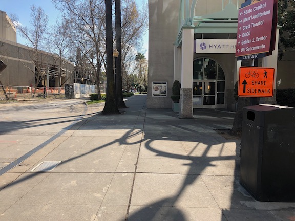
The convention center and community center theater project (3C) project did a very poor job of preserving access for walkers and bicyclists at the beginning. Some issues have been resolved, but some never have, though the project has now been going on for just less than two years.
The most significant issue is that there was no provision made for northbound bicyclists on 13th Street, passing the construction between L Street and J Street. 13th is a major bicyclist route of travel, and the city knew this before the construction started. But the original traffic plan did not address this use at all. After public complaints, a sign was installed on the sidewalk for northbound bicyclists, photo below, but not the southbound. The numerous walkers using this sidewalk, adjacent to the Marriott and Sheraton convention facilities, were confused to see bicyclists on the crowded sidewalk. After more public complaints, a sign was added southbound, the second photo, though it is placed in a location where people coming from K Street would not necessarily see it. As you can see in the first photo, the sidewalk is narrow just north of the crosswalk, so bicyclists heading north are brought into immediate conflict with pedestrians heading south, many of whom are headed to the crosswalk over L Street. Of course having an angled ADA ramp here, rather than the two-to-a-corner design that should be used wherever there is significant pedestrian traffic, makes things worse.
Of course the best solution here would have been to just close 13th Street to motor vehicles between K Street and L Street, leaving the narrowed roadway available for two-way bicyclist traffic. There are far more bicyclists using this route than private vehicle drivers. Despite that, the city biased in favor of drivers.
13th Street northbound at L Street13th Street southbound at K Street
One issue on which progress was made was the southeast corner of J Street and 13th Street. Initially this corner was closed, giving walkers only one choice of how to cross, despite this being one of the most heavily used intersection crossings in the city. There was no reason to close the corner off, the area behind the fence was never used for construction. After about a year and a half, the corner was re-opened, photo below, so that walkers have a choice of routes. Note that when the city finally worked on this corner, the work was not done behind the fence, but the fence was moved and then the sidewalk and ramp work done by closing off the corner until it was done.
J Street & 13th Street, southeast corner, finally re-opened
On the east side of the project, issues remain. The sidewalk from J Street south along 15th Street has no signing indicating that it is closed ahead, see photo. When you get half way, there is just a fence blocking access. In daylight, you can see the fence ahead, but a limited vision person and anyone walking at night would not see the fence until they got to it. This is simply unacceptable.
15th Street west side, southbound from J Street, no signage
There are several other less serious issues around the east and south sides. At K Street & 15th Street, there is no signing to indicate how to get to the other side, to go either northbound or southbound. This one is not hard to figure out, at least for sighted people, but it was still not done correctly. This crosswalk ramp should have been barriered off, just like the ADA compliant barriers in the previous post, since it only leads to a closed crosswalk.
On the south side of the project, there are plastic barriers for the crosswalk over 14th Street at L Street, and for the crosswalk over L Street on the west side of 14th Street. These barriers were knocked over months ago and have not been put up again. There were not sufficient to begin with, but laying down on the ground, are both useless and hazardous.
14th Street at L Street, failed barrierL Street at 14th Street, west side crosswalk, failed barrier
I’m going to call this one a failure on the part of both the construction company and the city: the construction company for failing to monitor and maintain the traffic control devices for which they are legally responsible, and the city for failing to monitor the construction company. Blame all around!
And lastly, the closure of a lane on L Street for the construction was not handled well. As you can see, there is a narrow crosshatched area the length of the block. One might reasonable choose not to go this way, but then again I see people going this way every day, both walking and bicycling. I am not sure how this should have been handled, but there must be a better solution. Of course one solution would have been to continue a temporary pedestrian walkway on the north side of the street, set off by concrete barricade, and requiring only a simple fence to separate the walkway from the construction site. If more street width was required, parking could have been removed from the south side and the general purpose lanes shifted to the left. Note there there never was a bicycle lane present in this block, it is dropped at 15th Street and the traffic sewer 3-lane roadway continues west.
L Street westbound at 14th Street, narrow shoulder
In closing, this construction project is probably the worst in the city (though there is competition). It does not involve a private property owner, it does not involve a state construction project, it is a city project on city land. There is simply no excuse for such poor walker and bicyclist accommodation. It is a big middle finger to those to who don’t drive.
Since there will likely be a long string of posts on construction zones done wrong, I want to point out that they can be done right. This is one from yesterday. Though the crosswalk closure here was less than one day, it was signed properly, and the detour was very short, about 30 feet west to the next crosswalk.
N Street at 12th, clear construction zone signingN Street at 12th, clear detour signing