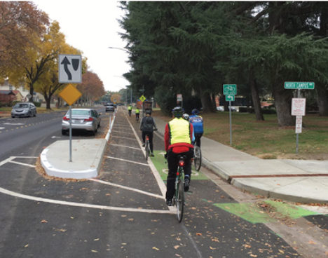
Halloween streets?

Halloween is traditionally one of the most dangerous days/nights of the year for children, due to traffic violence.

Last year I was in Davis by chance for their downtown kids-oriented Halloween celebration, Treat Trail. The sidewalks are filled with kids in costumes, and their parents sometimes too. Local businesses give out candy and other treats. I have never seen such a community oriented celebration, not just of Halloween, but of Davis. Several things make this event safe. It is in the afternoon, not in the dark. The mass of kids and families makes everyone pay attention, including drivers. Drivers in Davis are much more respectful of people walking (and bicycling) than are drivers in Sacramento.

Yes, I realize Halloween, on Saturday, October 31, is only two days away, too late to organize something for this year. But since I forgot to post in a timely manner, better now so that I can re-post it next year.
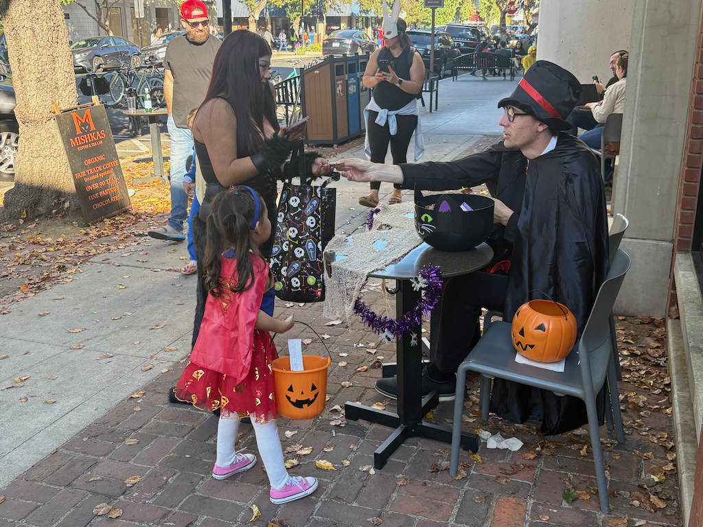
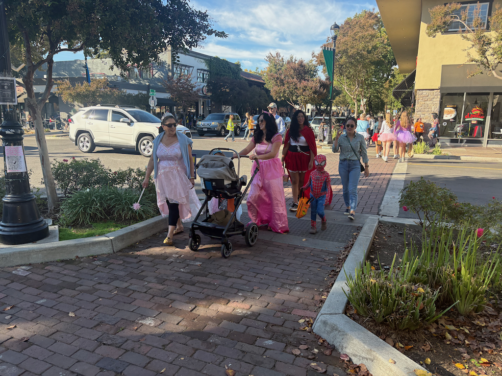
In Sacramento, many families won’t let their kids go out, for fear of traffic violence. There are organized ‘trunk-or-treat’ events where people give out candy from the trunk of their cars, which is as far from the spirit of Halloween as I can imagine, and a sure sign of motor vehicle hegemony, that it is only safe to be around motor vehicles when they are not moving.

Could Sacramento do something like Davis? Yes, but only on streets closed to cars. The danger from drivers is just too great on streets open to cars in Sacramento. Where could this happen? It could happen anywhere that the neighbors or businesses got a permit and bought or rented barriers, and paid for police overtime.

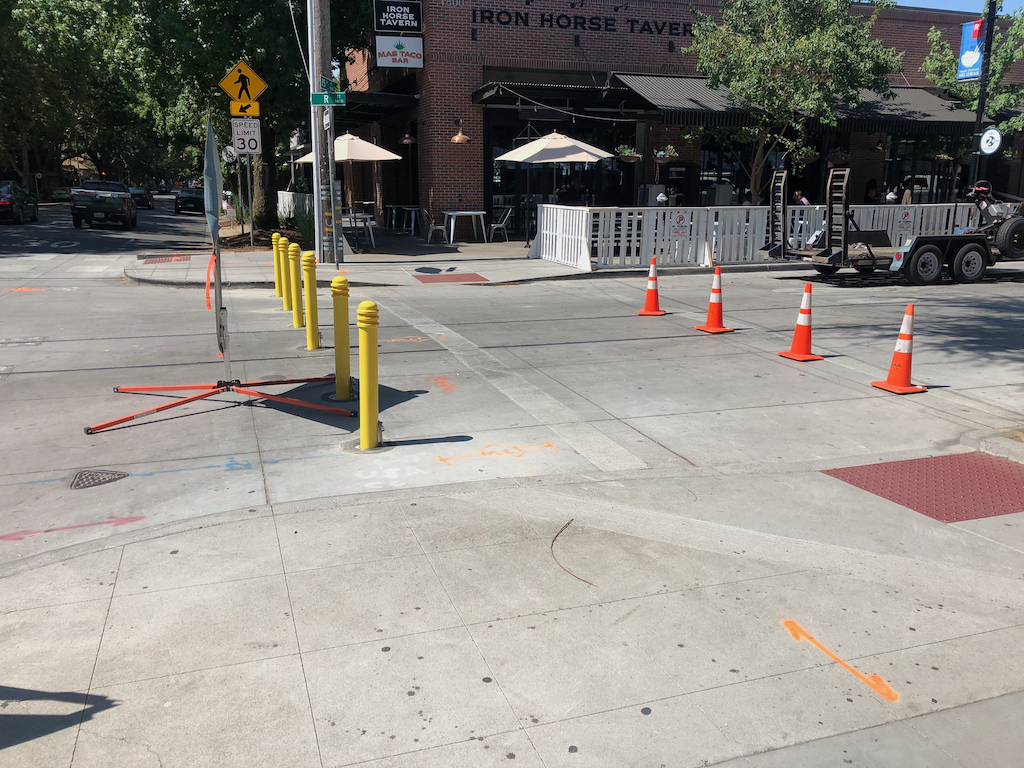
But there are two locations in central city Sacramento where the streets are already set up to be closed to cars, and open to trick-or-treat, R Street corridor, and the 20th Street & K Street farmers market area, where the streets can be closed with bollards. Bollard bases have been installed at a number of intersections, and at many of these, the bollards are waiting in bollard corrals to be placed. The photo below shows bollards on R Street at 15th Street, during the pandemic closure of R Street, but the bollard bases and bollards are still being used for special events. What better special event than a Halloween street for kids?

I don’t know which blocks would provide the best experience for kids and business owners. It requires a certain density of supportive local businesses to be successful.

Just showing up today, the post ‘Map: Where are San Francisco’s Halloween events and car-free streets?‘ on Mission Local. Note that searching for ‘halloween car free streets sacramento’ turns up nothing. There are events in parking lots, and parks, and community locations, but nothing on streets. Absolutely nothing.

And, Why Halloween Can Be Dangerous in America (Bloomberg 2026-10-28).
Midtown 20th Street & K Street

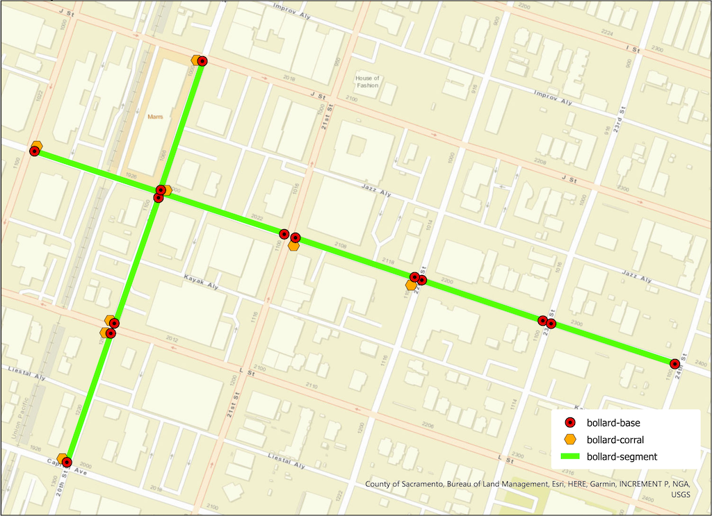
The map below (pdf) shows the bollard base ‘fences’ at intersections, the bollard ‘corrals’ where bollards are stored when not in use, and the ‘bollard streets’ that can be easily closed to motor vehicles and opened to people walking, including kids. The streets segments are 20th Street between Capitol Avenue and L Street, L Street and K Street, and K Street and J Street; and K Street between 19th Street and 21st Street, 21st Street and 22nd Street, 22nd Street and 23rd Street, and 23rd Street to 24th Street. The Saturday Midtown Farmers Market uses 20th Street between Capitol Avenue and K Street (to north to I Street), and K Street between 19th Street and 21st Street. I have not been the eastern segments being used, but they may be.
R Street Corridor

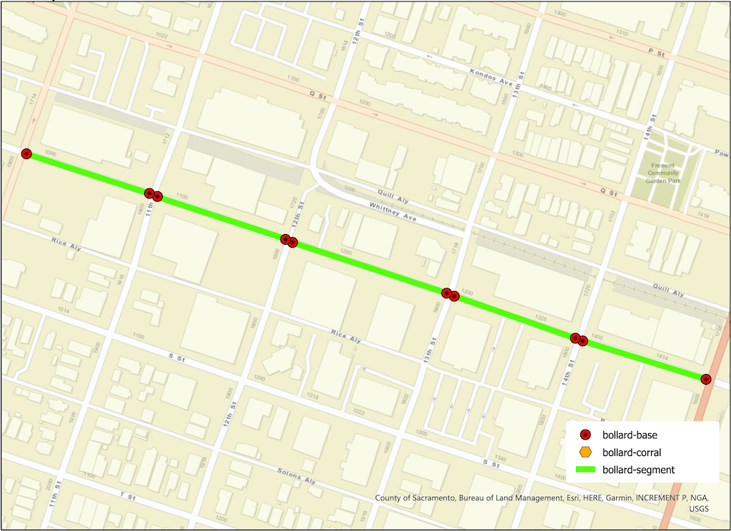
The map below (pdf) shows the bollard base ‘fences’ at intersections, and the ‘bollard streets’ that can be easily closed to motor vehicles and opened to people walking, including kids. There are five segments from 10th Street to 15th Street. The cross-sections do not have bollard base ‘fences’. There are no ‘bollard corrals’ for storage, so they must be stored elsewhere. I have seen several of these segments in use for night market, craft markets, and other community events.
J St bikeway

The J Street separated bikeway has problems, as has been highlighted by Streets are Better and many others. Separated bikeways are also called protected bike lanes and cycle-tracks, but in California the official term is separate bikeways.

The City of Sacramento placed a separated bikeway on J Street from 19th Street to 29th Street as part of a repaving and roadway reallocation project called the J Street Safety Project in 2018. This was the second such project in Sacramento, the first being portions of P and Q Street downtown, but it was the first in the heavy retail, parking, and traffic environment of J Street.

The theory of these parking-protected bikeways is that the row of parked cars protects bicyclists from moving cars, and this is true in the length of the block (but not at intersections, which are a separate issue), when there are parked cars. But some times of day there are not parked cars, and throughout the day as cars come and go (particularly on a retail corridor), protection is lacking.

It is true that bikeways don’t need strong protection from PARKed cars, but they do need protection from PARKing cars and delivery vehicles, and bikeway intrusion.

Vertical delineators and pavement markings were used to set off the bikeway, with a sign at the beginning of each block segment showing the new allocation. These vertical delineators are also called bollards and soft-hit posts, with soft-hit meaning that they won’t damage cars when drivers hit them. The first photo below shows the 27th to 28th section. It initially had 14 delineators place, but only three are remaining. The other blocks have fared a little bit better, but overall about half the delineators are gone. The second photo shows the 25th to 26th section sign that has been run over by a driver.

J Street bikeway, 27th to 28th section, missing delineators
J Street bikeway, damaged sign

Some of the vertical delineators are being run over by people parking, some by delivery vehicles parking on top of them, and some by drivers going down the bikeway itself. And probably some just for sport. I don’t know which of these causes are most common.

There are several solutions:

One: Put the delineators closer together so as to make it more obvious that vehicles are not supposed to cross them.

Two: Add bollards which either are, or at least look to be, more substantial. The photo below is from a somewhat different setting in Oakland, with more substantial bollards. Reading blogs and Twitter, these seem to be successful in some cities and some settings, but not in others.

bollards in Oakland

Three: More substantial separators such as planter boxes.

planter separated diagram from C40

Four: Partial hard curbs or medians. The photo shows a median at the start of a bikeway section. It reduces the number of signs flattened by drivers and signals to drivers that there is something different about this block.

bikeway with hard median start, FresnoCOG

Five: Continuous hard physical curb or median. It is hard to find good photos of these, probably because in the past they haven’t been seen as necessary. There are a lot of photos of hard medians adjacent to moving traffic, and adjacent to two-way cycle-tracks, and alongside raised bike lanes that are at or close to sidewalk level. But the graphic below gives the general idea.

Of course hard curbs or medians are more expensive, but last 20-30 years whereas delineators or bollards may need to be replaced every year, so I think they are a good investment.

A major issue with all separate bikeways is the presence of driveways. In fact streets with a high density of driveways should not have this design. Below at the blocks of the bikeway, with information about driveways.

19th3 drivewayspartially separated; driveways not changeable
20th3 driveways2 changeable driveways
21st1 drivewaydriveway not changeable
22nd2 driveways2 changeable driveways
23rdno driveways
24th2 driveways1 maybe changeable
25thno driveways
26thno driveways
27thno driveways
28th2 drivewayspartially separated; 1 driveway changeable

The changeable driveways will be the topic of a separate post, but the basic idea is that parking lots that have access to the alleyway do not need access to the main street, so in this case, parking lots with access to Jazz Alley do not need access to J Street.

My recommendations

  1. Place hard medians at the beginning of each block, to protect the signs, and better signify to drivers this is a different place. For the locations where there are bus stops (19th, 22nd, 25th, 27th, 28th), the median would be moved down the block a bit. Note that this is too high a frequency of bus stops, but that is an issue for another post.
  2. Place more substantial bollards, and at a closer spacing.
  3. Place a continuous hard median on one of the four blocks without driveways, the same width at the painted buffers present now. This would be a pilot to test the installation, determine costs, and document benefits. If the pilot is successful, the other three blocks with no driveways should receive the same treatment.
  4. Start negotiation between the city and the owners of parcels that are used solely as parking lots, to close J Street driveways and use Jazz Alley access. Some of these parcels will be redeveloped into more productive uses anyway, but that may take longer than desired.