The Sacramento Active Transportation Commission (SacATC) will meet Thursday, October 16, 2025, at 5:30 PM. The meeting will be at Sacramento City Hall, council chambers. The meeting is livestreamed from the Upcoming Meetings Materials page at the time of the meeting. Comments may be made in-person, or via eComment on the Upcoming Meetings Materials page up to the time of the meeting, but should be submitted well ahead of time if you wish the commission members to see the comment before the meeting. No comments are taken online.
Open Session Roll Call Land Acknowledgement Pledge of Allegiance Consent Calendar All items listed under the Consent Calendar are considered and acted upon by one Motion.
Approval of Active Transportation Commission Meeting Minutes
At last night’s Sacramento Active Transportation Commission (SacATC) meeting, the 9th Street Separated Bikeway was item 3 on the agenda. As is usual, I did not have a chance to review the item until shortly before the meeting, so did not post comments ahead of time, but did make comments during the meeting. I’ve broken the agenda item into staff report, plans, and presentation slides for easier access.
This was the preliminary presentation on this project, and it will be revised and come back to the commission at least once more.
My comments text, thought some particulars were left out due to the two-minute time limit:
I am glad to see the project, since it closes one of the gaps that makes the existing separated bikeways less useful.
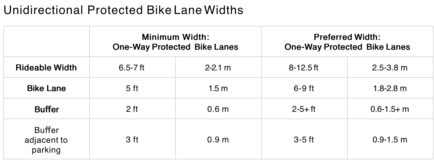
Widths
The six-foot bikeway width does not meet NACTO recommendations (preferred width) of 8 feet or more for separated bikeways. Six feet does not allow for passing or wider bicycles, and is NOT a best practice.
I support bin/leaf zones, but the entire buffer should be wide enough to accommodate bins, as has been implemented on some blocks of P and Q streets. I am not sure how wide this is, but it is more than 3 feet.
In order to gain the necessary width for bicycles and buffers, the street right-of-way needs to be reallocated:
One of the two general purpose lanes should be 9 feet (the left lane), the other 10.5 feet (the right lane), which gains 2.5 feet. The wider lane would be used by buses on SacRT Route 51. The wider lane should be marked as such, with the width painted on the pavement at every intersection to inform drivers.
Similarly, one of the two parking lanes should be 7.5 feet, which gains 0.5 feet, and signed or marked as a narrower parking lane. The city does not need to accommodate car bloat on every street and every parking lane.
Bikeway Protection
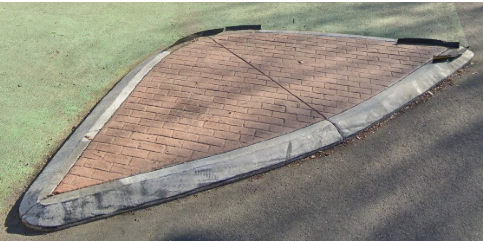
I support turn wedges, but they should be concrete, not solely paint and posts. Though the paint and post turn wedges provide some safety for bicyclists, and particularly for walkers, they are less safe than concrete, which the city calls ‘rolled curb turn wedge’.
SacCity photo of a rolled curb turn wedge
Any block with only an alley break in the separated bikeway should be protected by concrete curbs, not simply by paint and posts. Where driveways occur, it may be better to use paint and posts.
Marking
Whenever a bikeway crosses general purpose lanes, as it does approaching Broadway, the merge zone must be marked with green backed sharrows. Anything less is unsafe for bicyclists.
Any place where a bikeway transitions from one side to the other side is designed, there must be a bike signal to control motor vehicle traffic. In general, bicyclists need an exclusive bike phase, where no motor vehicles are turning. The side-to-side transitions on 19th Street (from left to right, just past W Street), and 21st Street (from right to left at W Street) are NOT safe for bicyclists, and as a result, there are many fewer bicyclists using these streets than was intended or is desirable. The city has resisted using bike signal faces, though the expense is a fraction of what the city routinely spends replacing functional signals and signal boxes.
Any time a bikeway is between two general purpose lanes, as it is approaching Broadway, the bikeway must be marked with continuous green paint. Somehow the plans dropped green paint between W Street and Broadway, the most confusing and potentially deadly part of the entire project.
Commissioners made a few comments:
Generally supportive of the project intent
Moore commented on green paint approaching Broadway, and asked if the transition could be earlier to reduce conflicts at the W intersection; staff response it that right-turning vehicles at W Street are the biggest conflict, other than X Street and Broadway
Hodel supported the red paint daylighting, and asked for green paint approaching Broadway
Apparently there were a large number of eComments on the agenda items, though I’m unsure how many related to this agenda item or the other three main items. When the meeting is over, all the eComments disappear, apparently into the ether. This is not just a problem for SacATC, but for all city meetings. Unless a citizen takes care to capture the eComments before the meeting ends, they will never know what others commented online.
The NACTO Urban Bicycle Design Guide (3rd edition, 2024) includes the diagram below within the ‘Designing Protected Bike Lanes‘ section.
NACTO One-Way Protected Bike Lanes Design Guidance
The Sacramento Active Transportation Commission (SacATC) will meet Thursday, September 18, 2025, at 5:30 PM. The meeting will be at Sacramento City Hall, council chambers. The meeting is livestreamed from the Upcoming Meetings Materials page at the time of the meeting. Comments may be made in-person, or via eComment on the Upcoming Meetings Materials page up to the time of the meeting, but should be submitted well ahead of time if you wish the commission members to see the comment before the meeting. No comments are taken online.
Strong SacTown will again be hosting a Park(ing) Day event on Saturday, September 20, 2025. The location will be 20th Street & L Street, adjacent to the Midtown Farmers Market, and the time 9:00 AM to 1:00 PM. The location should attract curious people from the farmers market, as well as passerbys. You can sign up with Strong SacTown at https://bit.ly/sstparkingday2025 (the link in the newsletter and meeting slide below is malformed, so use this one) to help with planning and hosting on the day, including setup and breakdown. Whether you stop by or get involved, don’t miss it!
The international Park(ing) Day website provides background and history about the events. Note that Sacramento’s day is Saturday, September 20, not Friday, September 19. It also provides a description of the event:
“On Saturday, September 20, Strong SacTown is hosting Park(ing) Day, a community celebration where we reimagine Sacramento’s streets. We’ll highlight the new daylighting law (AB 413), invite neighbors to brainstorm how we can use these reclaimed spaces, and enjoy fun activities like bike tune-ups, games, and a mini bike lot. This is a chance to spark creativity around how Sacramento can use daylighted corners for seating, greening, and gathering.”
Note that in addition to Park(ing) Day, the Midtown Farmers Market runs 8:00 AM to 1:00 PM, and the Sacramento Porch Fest in midtown runs 12:00 noon to 10:00 PM, all in this most livable neighborhood of Sacramento.
The Sustainable Transportation Fair, sponsored by 50 Corridor TMA, will be held Wednesday, September 17, 2025, at the state Capitol, west side, from 11:00 AM to 1:00 PM.
Do you commute downtown? Cut down on your commute expenses, parking headaches, and traffic. Come meet local transportation experts to guide!
The Sustainable Transportation Fair is an event dedicated to promoting sustainable commuting options and raising awareness about sustainable transportation. Local vendors and transportation organizations will be on hand to share information about alternative travel solutions.
In the last year, we have seen an increase in traffic due to return-to-office orders for State workers. Promoting sustainable commute options continues to be a high priority. Doing so can help ease parking and rush hour stress, improve road safety, save you money, and reduce our environmental impact. This event provides the resources needed to discover the best commuting options for your lifestyle.
More information, and tickets, which are appreciated but not required, are on Eventbrite.
The Sacramento Transportation Authority (STA or SacTA) Board of Directors is meeting this Thursday, September 11, at 1:30 PM in Sacramento County Board of Supervisors chambers, 00 H St, Ste 1450, Sacramento.
Comments may be made in person, or via email ahead of time to BoardClerk@saccounty.gov. If you want board members to see your comment before the meeting, send it at least 24 hours in advance.
The meeting may be viewed online at Metro Cable 14. It will be the video on the home page, at the time of the meeting. Comments may not be made through the live stream.
For more information about the SacMoves Coalition presentation, see SacMoves to present at Sacramento Transportation Authority. I strongly encourage people interested in transportation and transportation funding attend the meeting, or at least view it online. SacMoves Coalition is being offered the opportunity to present before the stakeholder engagement process has started because it is a coalition of 25 organizations with interests in transportation funding and related issues.
The Sacramento Active Transportation Commission (SacATC) will meet Thursday, August 21, 2025, at 5:30 PM. The meeting will be at Sacramento City Hall, council chambers. The meeting is livestreamed from the Upcoming Meetings Materials page at the time of the meeting. Comments may be made in-person, or via eComment on the Upcoming Meetings Materials page up to the time of the meeting, but should be submitted well ahead of time if you wish the commission members to see the comment before the meeting. No comments are taken online.
This is a big meeting! I hope you can attend and comment, or use eComment. I have not yet reviewed the documents, but may add additions to this post if appropriate.
At the Sacramento Transportation Authority (SacTA or STA) meeting tomorrow, August 14, 2025, there will be a presentation on a County Wide VMT Mitigation Program. This is the second of three presentations, leading to an agency decision on whether to do a VMT mitigation program, and if so, what kind.
The state has authorized VMT mitigation programs under SB 743 (2013), and AB 130 (2025) authorizes VMT mitigation fees to be used for affordable housing in low-VMT areas. Design and implementation of the state VMT mitigation through housing program won’t come until next year.
SACOG is also considering a region-wide VMT mitigation program, but is in the early stages of determining the model and making a proposal.
I intend to take a closer look at these, and add to this post, and speak at the board meeting, but am not there yet.
This was unintentionally not posted in a timely manner, but may still be of use.
The SACOG Transportation Committee will meet this Thursday, August 7, 2025. The meeting may be viewed online during the meeting via the link provided on the SACOG Meetings & Agendas page. Comments may be made in person or ahead of time (48 hours if requested to be read during the meeting, otherwise they will not be read nor seen by committee members before the meeting) by email to clerk lespinoza@sacog.org. Comments may not be made online. The meetings are held at SACOG offices, 1415 L Street, Suite 300, Sacramento, CA, starting at 10:00 AM, usually lasting two hours. There is an optional presentation at 12:00 PM on Green Means Go.
The agenda items below have not been looked at in detail. If time permits, and there are significant issues, they will be added to this post.
Following committee roll call, public comment: Any person wishing to address the committee on any item not on the agenda may do so at this time. After ten minutes of testimony, any additional testimony will be heard following the action items.
Consent:
Approve Minutes of the June 5, 2025, Transportation Committee Meeting
Accept and Pass Through Federal Transit Administration Areas of Persistent Poverty and Innovative Coordinated Access and Mobility Funds to Paratransit, Inc.
I have participated in more agency planning projects than I can count, mostly transportation-related, but other topics as well.
Every project has a well-paid staff project lead, and sometimes other agency staff. Almost all have a well-paid outreach consultant, and almost all have very-well-paid technical consultants, sometimes several.
And then there is the community, the people with local knowledge that is critical to a successful project that meets the needs of the community. These people are rarely paid. Sometimes there will be a focus group that receives some sort of stipend or something of value, but rarely. Sometimes community groups are contracted to bring community members together, but rarely. Sometimes advocacy organizations with some degree of local knowledge are contracted.
But just plain people, who live in their community, have local knowledge, and lived experience with challenges and opportunities, almost never. These people are expected to attend in-person or online workshops and provide their knowledge, for free. This is wrong.
Sometimes food is provided at workshops and meetings, but not often, and when it is, is provided by community nonprofits, not by the grant or agency. There are restrictions on providing food with government grants (as though providing food is ‘wasteful’ while paying agency staff and consultants is not), so this particular issue is often not solvable by the grant recipients.
Child care can be provided by grants, but rarely is. The agencies expect parents to attend, but don’t welcome their kids. Meeting the needs of the kids is often the point of the grant, but the setup makes is difficult for families to participate.
I was just at a workshop, scheduled 5:30 to 7:00 PM. This is dinner time for many families. No surprise, community attendance was very low, with as many advocates as community members. Why are workshops at dinner time? Why are they not scheduled in the afternoon, when the caregiver parent can attend with their children, or after dinner time when the family can attend with their children?
The concept of community outreach is broken. It is the community members that should be treated well, not the professionals.