Note: I’ve updated this post to add some detail to the descriptions and photos to illustrate the treatments. I will be adding separate detailed posts on some of these treatments.
Following on my earlier posts about changing streets in downtown/midtown Sacramento, here are additional street changes that might be used in some places:
Reduce speed limit: Reduce speed limits throughout downtown/midtown to 20 mph. Of course simply reducing speed limits does not ensure that actual speeds go down, unless other measures are taken. The removal of three-lane and one-way streets will help a great deal, since these are the streets that most encourage speeding. Other changes suggested below will also slow traffic. I think, however, that the primary change will be a change in attitude, in cultural values. Once a place becomes more livable, people will focus more on being there instead of going through there to somewhere else. I see the whole pace of life in downtown/midtown as being slower, living at the pace of a walker, or even the pace of a casual conversation, rather than at the unnatural pace of a motor vehicle.
In my previous post, I suggested two major changes to the street grid in downtown/midtown Sacramento, one to eliminate one-way streets, and the second to convert all three-lane streets to two-lane streets. Of course there is an overlap between these changes, as all of the three-lane streets are also one-way streets.
The goal of these changes is to make it harder to commute to and from downtown Sacramento by car. Yes, that is my intention.
By way of explanation, I go back to Williams Burg’s documentation of the intentional de-population of downtown, and to a smaller degree, of midtown. There is an insufficient housing stock of all types in the downtown area, and in the midtown area there is a lack of some kinds of housing, primarily single family housing. I’m not talking here about separate housing, the suburban model of isolated houses on isolated lots in isolated communities, but of housing designed for families to live in that are not like apartments with shared facilities. Tapestri Square on 20th St is one example of this kind of single family housing, but there are many more both new and older. And of course there are Victorians still available which have not been subdivided into spaces too small for a family. Housing is gradually being added back into midtown. Where I live at 16th & O, there are two new mixed-use buildings going up, retail below and apartments above. There are others in midtown, and even a few in downtown.
The maps I posted the last two days were preliminary to this post. I would like to see two significant changes to the streets in downtown/midtown Sacramento that will make these areas more livable, more walkable, more bikeable, and safer. I am proposing the complete elimination of traffic sewers from downtown/midtown Sacramento. What is a traffic sewer? It is a street designed to move large volumes of vehicles at high speed in and out of work areas during morning and afternoon commute times. In Sacramento, the main work area is the state buildings downtown, though there are certainly other employers and other areas, including midtown.
3 to 2 conversion, 10th Street northbound
1. Convert all three-lane streets into two-lane streets. The map showing these streets in the downtown/midtown area is linked from my Sac 3-lane Streets post.
These three-lane streets are, of course, also one-way streets. In many cases the lane removed would be used to provide bike lanes or protected bikeways, but in some cases the space might be best used to create wider sidewalks or diagonal parking where additional parking is needed. Though in some cities the three-lane to two-lane conversion is used to create a turning lane, I don’t believe that these are necessary in downtown/midtown, nor do I feel that this is a good investment of right-of-way.
This conversion would remove some traffic capacity, though unfortunately, not as much as one might wish. Studies show only a slight reduction in capacity from this treatment, which is sometimes referred to as a road diet, though I like the term rightsizing.Read More »
At right is the second map of downtown/midtown Sacramento, showing the 1-way streets. This map was created using Google maps and memory, and has not yet been field checked.
These streets total about 32.6 miles.
The map graphic links to the map data in Google Maps, from which you can zoom in on areas and turn on or off satellite view. The reason that this is not a map view graphic is that the online browser version of Google Maps starts paging after about 18 entries, so it is not possible to view all of the segments at the same time. This image is instead from Google Earth, via KML export and import.
The map provides background for an upcoming post about transforming transportation and livability in downtown/midtown.
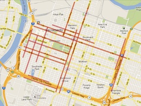
At right is a map of the 3-lane (or more) streets in the downtown/midtown section of Sacramento. All of these streets are also one-way streets. Many people call this the grid, but others define the grid as a larger area including areas east of Alhambra Blvd and south of Broadway. This map was created using Google maps and memory, and has not yet been field checked.
These streets total about 25.4 miles.
The map graphic links to the map data in Google Maps, from which you can zoom in on areas and turn on or off satellite view.
The map provides background for an upcoming post about transforming transportation and livability in downtown/midtown.
The first weekend in April is shaping up to be great fun for people like me who love themed slow rides.
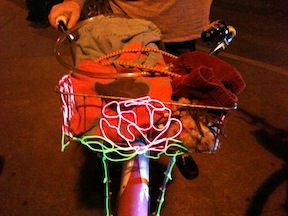
Friday, April 5th will be the next edition of BikeParty Sacramento, somewhere in the Land Park neighborhood. I participated in the March ride, whose theme was Massive Mural March, and it was a hoot. Many people came with highly decorated bikes, twinkly and sparkly and flashy, with fuzzy stuffed animals and fuzzy wild clothing. The murals scattered through midtown, some of which I’d seen before and many of which I had not, were entertainment enough, but the people themselves and their bikes were even better entertainment. Electroluminescent (EL) wired was common. EL is popular with the Burning Man crowd, and it is so cool, I just have to get some of my own. The photo is an EL rose designed and built freehand by the owner (whose name I’ve forgotten). The event is coordinated by Conrad, who rides and designs crazy art bikes.
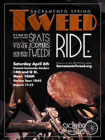
Saturday, April 6th will be the Tweed Ride, starting at Fremont Community Garden in midtown. Last year after a successful run, Rick Houston retired from sponsorship of the Sacramento Tweed rides, but Brian and Sarah have taken on the mantle are continuing under Sacramento Tweed Ride 2.0 (Facebook) and Sacramento Tweed (blog). Some people come dressed to the nines in 1920’s fashion, with tweed prominent, some people come with vintage bikes older than almost any of us, some people come with both, and many people come just because it’s fun and they want to find out more about it. For the last ride I went on, I rode my Brompton, which is not truly vintage but has a vintage British flavor, and wore my Victorian clothing, which is quite pre-1920’s, and was accepted in just fine. I hope to have some real tweed by the next ride.
These themed slow rides are a great way to socialize with the non-spandex crowd. They often include stops for coffee or beer or chocolate, and visit interesting places that you might not otherwise know about. Though I have an innate reluctance to ride in groups, as they introduce hazards that don’t exist for individual riders, these rides are so fun and such a positive experience that I’m willing to overcome my reluctance. The pace is such that anyone can keep up, on any kind of bike.
Unfortunately, the first weekend in April I am in the bay area for the Epicenter contra dance weekend in Mill Valley, and so will miss both rides. Hope you don’t miss them!
Sacramento Area Bicycle Advocates (SABA) posted a question on Facebook, “Where shall we hold one in Sacramento?” about the Sunday Streets event this past Sunday on the Embarcadero in San Francisco. This echoes a conversation Alexis and I had while we were attending. She liked the Embarcadero Sunday Streets because it was a long distance and showed how streets can be used for transportation in a different way than we usually use them. For Sacramento, that would argue for a long distance closure that connects together destinations.
Though I certainly enjoyed this Sunday Street, I really like the two that I’ve been to in the Mission neighborhood of San Francisco, which close stretches of Valencia St and 24th St. This route is in a neighborhood, there are people living along the streets and in the neighborhood, as well as those who come from other places to enjoy. There are a multitude of locally-owned businesses to appreciate and engage, with nary a chain in sight. The special events such as play areas, climbing walls, hula hoops, dance demonstrations and others feel more concentrated rather than scattered out along a long route. For Sacramento, this argues for a midtown location, which is the only area where there is a sufficient concentration of residents and locally owned businesses. The Mission event is about community, and more like a street fair.
Embarcadero is more about transportation, and Mission is more about community. Sacramento, of course, could do both.
For more information about the flavors and locations of open streets events, see Open Streets Project. Check out the website for background information including “models”, and then go to one! Of course San Francisco is the easiest for us here in the Sacramento region, but Berkeley will also be having one or more this year, and as you’ll see, they are becoming common on the west coast, throughout the United States, and the world.
The next San Francisco event is on April 14, and is in the Mission neighborhood which I’ve referred to above, on Valencia St and 24th St. Don’t miss it! And bring back your thoughts and commitment to making it happen in Sacramento.
Alexis and I volunteered at the event as intersection monitors. Once you’ve been to an event, you can consider volunteering, which provides a different perspective. Though I was initially assigned to an quiet intersection where there was nothing much to do, I got moved to a lively intersection, The Embarcadero and North Point, where the F streetcar line crosses The Embarcadero at an angle, and there was a lot to do, stopping the walking-biking-rolling crowd as the streetcar came through, keeping people out of the dedicated streetcar lane, and talking to people about how to safely cross tracks.
 Reduce speed limit: Reduce speed limits throughout downtown/midtown to 20 mph. Of course simply reducing speed limits does not ensure that actual speeds go down, unless other measures are taken. The removal of three-lane and one-way streets will help a great deal, since these are the streets that most encourage speeding. Other changes suggested below will also slow traffic. I think, however, that the primary change will be a change in attitude, in cultural values. Once a place becomes more livable, people will focus more on being there instead of going through there to somewhere else. I see the whole pace of life in downtown/midtown as being slower, living at the pace of a walker, or even the pace of a casual conversation, rather than at the unnatural pace of a motor vehicle.
 In my
In my