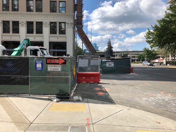
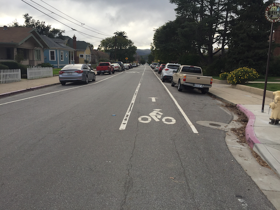
Yet another. There is a construction project, or at least a fencing off for future construction, at 830K, a long abandoned building. Along 9th Street, a fence has been put up where there used to be a bus stop, extending from K Street to and including Kayak Alley.
Southbound at K Street, there is no signing on the fence at all. This is not a major flaw, as it is obvious the sidewalk is closed, but there is no information about how far the closure extends.
9th Street southbound at K Street, west side (830 K)
From the south end, things are much worse. There is no signing at L Street to indicate there is a closure ahead. When you get to the closure, there is a random assortment of barricades, each of which is non-ADA compliant, and not indication which way to go. If Kayak Alley were open, it would at least offer an alternative, but the alley is closed.
9th Street, northbound at Kayak Alley, west side (830 K)
The worst part of this is that, so far as I can tell, nothing is going on here. The sidewalk, and bus stop, was closed off by fencing, but since then, nothing is happening. The point here is that there should be requirements placed on construction projects that if they stall out, the sidewalks must be returned to their previous open condition until such time as construction resumes.
The convention center and community center theater project (3C) project did a very poor job of preserving access for walkers and bicyclists at the beginning. Some issues have been resolved, but some never have, though the project has now been going on for just less than two years.
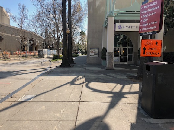
The most significant issue is that there was no provision made for northbound bicyclists on 13th Street, passing the construction between L Street and J Street. 13th is a major bicyclist route of travel, and the city knew this before the construction started. But the original traffic plan did not address this use at all. After public complaints, a sign was installed on the sidewalk for northbound bicyclists, photo below, but not the southbound. The numerous walkers using this sidewalk, adjacent to the Marriott and Sheraton convention facilities, were confused to see bicyclists on the crowded sidewalk. After more public complaints, a sign was added southbound, the second photo, though it is placed in a location where people coming from K Street would not necessarily see it. As you can see in the first photo, the sidewalk is narrow just north of the crosswalk, so bicyclists heading north are brought into immediate conflict with pedestrians heading south, many of whom are headed to the crosswalk over L Street. Of course having an angled ADA ramp here, rather than the two-to-a-corner design that should be used wherever there is significant pedestrian traffic, makes things worse.
Of course the best solution here would have been to just close 13th Street to motor vehicles between K Street and L Street, leaving the narrowed roadway available for two-way bicyclist traffic. There are far more bicyclists using this route than private vehicle drivers. Despite that, the city biased in favor of drivers.
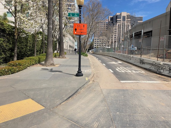
13th Street northbound at L Street13th Street southbound at K Street
One issue on which progress was made was the southeast corner of J Street and 13th Street. Initially this corner was closed, giving walkers only one choice of how to cross, despite this being one of the most heavily used intersection crossings in the city. There was no reason to close the corner off, the area behind the fence was never used for construction. After about a year and a half, the corner was re-opened, photo below, so that walkers have a choice of routes. Note that when the city finally worked on this corner, the work was not done behind the fence, but the fence was moved and then the sidewalk and ramp work done by closing off the corner until it was done.
J Street & 13th Street, southeast corner, finally re-opened
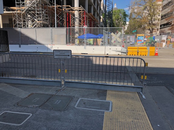
On the east side of the project, issues remain. The sidewalk from J Street south along 15th Street has no signing indicating that it is closed ahead, see photo. When you get half way, there is just a fence blocking access. In daylight, you can see the fence ahead, but a limited vision person and anyone walking at night would not see the fence until they got to it. This is simply unacceptable.
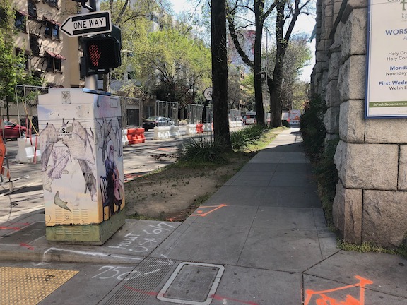
15th Street west side, southbound from J Street, no signage
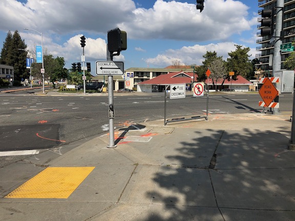
There are several other less serious issues around the east and south sides. At K Street & 15th Street, there is no signing to indicate how to get to the other side, to go either northbound or southbound. This one is not hard to figure out, at least for sighted people, but it was still not done correctly. This crosswalk ramp should have been barriered off, just like the ADA compliant barriers in the previous post, since it only leads to a closed crosswalk.
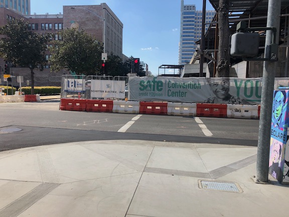
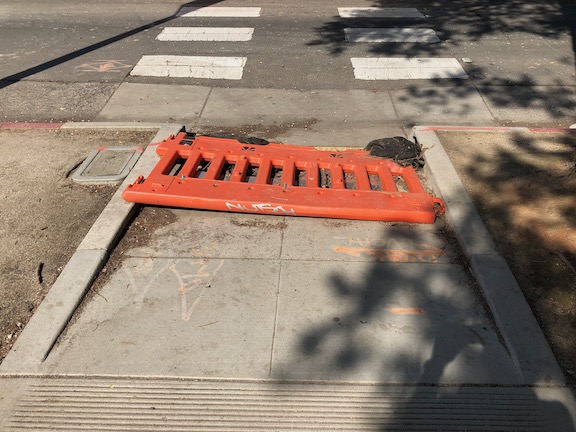
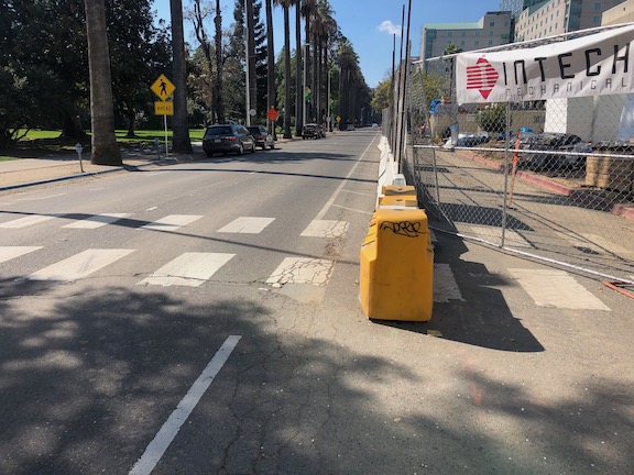
On the south side of the project, there are plastic barriers for the crosswalk over 14th Street at L Street, and for the crosswalk over L Street on the west side of 14th Street. These barriers were knocked over months ago and have not been put up again. There were not sufficient to begin with, but laying down on the ground, are both useless and hazardous.
14th Street at L Street, failed barrierL Street at 14th Street, west side crosswalk, failed barrier
I’m going to call this one a failure on the part of both the construction company and the city: the construction company for failing to monitor and maintain the traffic control devices for which they are legally responsible, and the city for failing to monitor the construction company. Blame all around!
And lastly, the closure of a lane on L Street for the construction was not handled well. As you can see, there is a narrow crosshatched area the length of the block. One might reasonable choose not to go this way, but then again I see people going this way every day, both walking and bicycling. I am not sure how this should have been handled, but there must be a better solution. Of course one solution would have been to continue a temporary pedestrian walkway on the north side of the street, set off by concrete barricade, and requiring only a simple fence to separate the walkway from the construction site. If more street width was required, parking could have been removed from the south side and the general purpose lanes shifted to the left. Note there there never was a bicycle lane present in this block, it is dropped at 15th Street and the traffic sewer 3-lane roadway continues west.
L Street westbound at 14th Street, narrow shoulder
In closing, this construction project is probably the worst in the city (though there is competition). It does not involve a private property owner, it does not involve a state construction project, it is a city project on city land. There is simply no excuse for such poor walker and bicyclist accommodation. It is a big middle finger to those to who don’t drive.
And now, before going on to all the examples of failure to accommodate walkers and bicyclists, some examples of crosswalk/sidewalk barriers that are done right. These barriers are for the state office building being constructed on the north side of O Street between 11th Street and 10th Street. It is also the light rail alignment, and one of the busier light rail borderings is across the street at Archives Plaza.
These barriers are some of the few ADA compliant barriers in the entire city. These are hard barriers, not construction tape or plastic barricade poles that can be walked through without notice be a vision impaired person. They have a base plate which is detectable by canes. They are anchored to the sidewalk, so that they can’t be knocked over intentionally or accidentally. The signing is clear, that the sidewalk/crosswalk is closed, and that the route goes left, crossing O Street.
11th Street at O Street, northeast corner
At the opposite corner of the project, on 10th Street southbound, there is clear signing, even wayfinding signing for the State Museum. Though the sidewalk is open for half the block, the barriers and signing make clear that a crossing of 10th Street is the appropriate action. Again, these are ADA compliant barriers.
10th Street east side, southbound from N Street
On 11th Street northbound, there is ‘share the lane’ signing, which is not ideal but serves acceptably in this situation with narrow street width. On 10th Street northbound, the bicycle lane has been carried through by shifting travel lanes to the left (west) and removing parking (no photo, but I will add one later). This is a good solution to accommodating bicyclists.
11th Street northbound
The remaining photos below show the other barriers and signing for this construction project. I don’t know why this one was done correctly, when most of the others are not. Was it the construction company that insisted on doing it right? Was it the state? Was it the city?
10th Street at O Street, northwest corner, crosswalk barricadeO Street at 10th Street, southeast corner, barricade and signingO Street at 11th Street, southwest corner, barricade and signing
Now onto a construction signing instance that would be laughable if it weren’t dangerous and offensive.
11th Street & J Street, northwest corner
Take a look at the signing, and think about what it means….
The orange detour sign is telling you the detour goes left, to cross J Street, while the permanent pedestrian prohibition signing tells you not to cross J Street here. Leaving along the issue of a stupid place to put a pedestrian prohibition (it is here simply to favor the drivers whipping out of the garage exit on 11th Street and wanting to take the right without stopping), this is nonsensical. This is one of the few issues that I do blame the construction company for. It was eventually corrected, the orange detour sign was turned around to face eastbound walkers, where it should have been, but it was this way for more than 24 hours. Does the construction company care so little about safety that it just puts up signs without thinking about them? Well, yes.
Since there will likely be a long string of posts on construction zones done wrong, I want to point out that they can be done right. This is one from yesterday. Though the crosswalk closure here was less than one day, it was signed properly, and the detour was very short, about 30 feet west to the next crosswalk.
N Street at 12th, clear construction zone signingN Street at 12th, clear detour signing
Construction projects all over the city of Sacramento continue to bias motor vehicle travel over walkers and bicyclists. This has been going on for a long time, and it has not gotten any better. A few construction projects handle it appropriately, most do not.
One issue that I ran into yesterday is particularly galling because of the long detour it takes to bypass the construction site at the corner of J Street and 4th Street, at the California Fruit Building (not sure if it will have the same name after reconstruction). From the southeast corner of J Street & 3rd Street to the southeast corner of J Street & 4th Street is 380 feet, along a sidewalk which has been closed by construction. The detour is 785 feet, but the important issue is not the distance but the time. The detour requires pressing five beg buttons and using five crosswalks, a walk of 7.25 minutes, most of that time waiting for the pedestrian signal to change. A direct route would be just over a minute.
J Street south side, eastbound past 3rd
This map (Google) shows the detour.
What are the alternatives? One is that a travel lane could be removed from J Street. Both a pedestrian walkway and a bicycle lane could be temporarily installed in this section past the construction. Another is to install a crosswalk on the east leg of the J Street & 3rd Street intersection. Pedestrian crossing is currently prohibited (by signing and guard rail) at this location, but the prohibition is solely for the flow of motor vehicle traffic and the convenience of drivers, it has nothing to do with pedestrian safety. The crosswalk need not be temporary, it could be a permanent installation. Of course this crosswalk would require two crossings, but two is better than five.
Short of these two real fixes, the signing could be better. In the photo below, there is an unobvious sign indicating a detour to the west, but it doesn’t say which sidewalk. I did not understand what it meant until I had walked down to the construction fence. On the sidewalk that is closed, there is no indication until reaching the construction fence that the sidewalk is closed. There should be some indication of how long, or how many crossings, for the detour. A person might decide to turn around and head south to L Street, or to the access points to K Street, if they had more information. This photo also shows the pedestrian prohibition established for traffic flow rather than pedestrians safety.
In the westbound direction, there is even less information. The sign says sidewalk closed, and there is a vandalised construction arrow, which might or might not indicate the detour route.
J Street south side, westbound at 4th
I don’t blame most of this type of issue on the construction companies. The construction company has to get a permit from the city, which includes a traffic plan. The city is accepting, and in some cases encouraging, traffic plans with no, or insufficient, accommodation for pedestrians and bicyclists, and insufficient signing. Of course the construction company wishes to minimize the work and the signing, but it should be the city’s responsibility to ensure good traffic plans. It rarely does. I will remind readers again that the city employee who supervises this permitting process said that pedestrians and bicyclists would be accommodated if it did not interfere with traffic flow.
Since I have time on my hands, I’ve been walking a lot more in downtown/midtown, with social distancing of course, so I hope to add additional posts on this topic.
Here in the city of Sacramento, most signalized intersections have beg buttons, the button you press to get the pedestrian crossing. Some of these are on auto-recall, which is what it is called when the pedestrian crossing (the white walker symbol) comes on every cycle. Most of them are not; the pedestrian crossing will never change unless you press the button. A few of them won’t ever change because the beg button is broken. You would think that the city would label the buttons with their function: is it required, is it not required, does it only affect the disability audible signal? Who knows. The city can’t be bothered to tell people walking how it works.
This is a huge frustration for walkers ALL the time, but now it is more, it is a public health hazard. Is there corona virus on that button? Probably yes. Is the city cleaning the buttons? Certainly no. So the city is allowing and encouraging a public health hazard by requiring walkers to use the buttons in order to cross the street. This must stop now! The city must set all pedestrian crossings to auto-recall, at least until the end of the pandemic, and hopefully forever.
I have been going on two long walks a day, or sometimes a bike ride, since self-isolating (no, I’m not sick). The only thing I have to touch in the outside world, other than my door knob when exiting and my door knob when returning, is beg buttons. Of course I don’t touch them. I cross when it is safe; I don’t waste my time waiting to see if this is one of those required, or simply decorative buttons. Because I won’t touch the button, I have to assume that every signalized intersection is broken, not accessible to pedestrians, and I therefore have a right to cross during gaps in traffic, no matter what the pedestrian signal says.
I hope that you found the series of posts on Walkable Sacramento useful. The posts received some comments, but not as many as I’d hoped. I’d ask you to go back to them and make comments. Though comments are few, I know that this blog is read by a number of transportation professionals and a few politicians, who could have a major impact in making Sacramento more walkable. Many of them don’t or can’t comment because of their job position, but they do read the posts and do read your comments, so your comments are valuable. The ideas and comments will also be considered as advocacy groups in the city and region develop their own, most likely milder, recommendations for policies and action to enhance walkability and safety for walkers.
I did not address bicyclist concerns and bikeability. That is not because it is not important to me. I bicycle a lot in the city, and do want to improve our streets for bicycling. Though the data is not in yet, I suspect that bike share has increased the rate of bicycling far above that for walking and other modes in the central city. However, the city has done better on providing bicycling facilities, and addressing specific areas of concern, for bicycling, relative to walking. I am also not unconcerned with the safety of people in motor vehicles, but there are plenty of people to advocate for that. As always, the greatest need for improvement in our transportation system is in the low-income neighborhoods which have been traditionally underinvested, and continue to be so.
So, get out there walking, and get out there advocating. Our streets will not get safer unless we all work to force the government to make them safer. The drivers will not help us, except for those more enlightened ones who remember that they walk also, and that the value of a place is determined by its walkability and not its driveability.
As you may have read here before, I am opposed to one-way streets, and feel that all or nearly all should be converted back into two-way streets. One way streets exist to speed the flow of car traffic. They do not exist to promote walkability or safety, and in fact are a significant detriment. Multiple-lane one-way streets encourage the multi-lane threat, where a driver in one lane stops, the pedestrian proceeds, and is hit by a driver in the other lane(s) who does not stop. I think one-way streets in Sacramento should be converted. Ironically, so does the city, but it has been reluctant to do so for fear of blowback from the cars-first commuters that use the one-way streets as traffic sewers to and from the freeways.
When there is discussion of one-way streets on the Internet, someone always puts up an example of a one-lane one-way street, either accidentally or purposively not understanding that it is multiple-lane one-way streets that are being talked about. But there are examples of one-way streets that work, if they are one-lane.
I was in San Luis Obispo (SLO) this last weekend for contra dancing, and had a chance to look again at many of the traffic calming features of that town. SLO has several one-lane one-way streets. Below is Pismo Street, which has a general purpose lane, a bike lane, and parking lanes on each side. The width is probably 28 feet, though I did not have a tape measure with me. I watched this street, a residential street, off and on over a period of three days. I did not ever seen anyone speeding on this street. When crossing the street walking, I had to only look in one direction, not two, and not multiple lanes. Judging from the pavement paint, and my memory of the last 10 years or so, I think this configuration has been in place for some while.
Pismo St, San Luis Obispo; one-lane one-way
This street configuration does not exist in the Sacramento region, so far as I know. The street width of 28 feet is also somewhat unusual. Most streets range upward from 32 feet.
SLO has also recently implemented a traffic calming one-lane one-way on Garden Street. This is a much fancier installation, involving decorative pavement, curb extensions, wider sidewalks, and other features. The drainage channel with different pavement does clearly separate travel from parking, and the handicapped spot is extra wide for loading and unloading from either side. I did not observe this street over a long period of time, but I did not see any speeding. Though the street does not have a posted speed limit, other than the general 25 mph, most vehicles were going well below that. I also saw people comfortably crossing the street mid-block, and drivers yielding to them. This is clearly a street that says ‘slow down’ and ‘stop to enjoy the restaurants and other businesses’, as it should, given the location in the walkable, destination-rich downtown area.
Garden St, San Luis Obispo; one-lane one-way
San Luis Obispo is not a walking paradise. There are multiple-lane one-way streets in the same area, where speeding does occur (note the one-way Marsh Street in the photo above, where speeding certainly does occur on a two-lane one-way street). Once out of the central city and old neighborhoods, it looks just like any place else in California, with wide residential streets and super-wide arterial roads. But it is a good model for the traffic calming that it has done well.
Smart Growth America has released its ‘Dangerous by Design 2019‘ report for 2019. Pedestrian (walker) fatalities have increased 35% over the last decade, becoming a bigger percentage of roadway fatalities, now at 16%. Sacramento (the Sacramento-Roseville-Arden-Arcade Metropolitan Statistical Area MSA) ranks 46 of 100 on the list of most dangerous areas for pedestrians, and the danger increased 4.9% from 2016 (year of the first report they did) to 2019. California ranks 16th on the list of states, and had an increase of 3.8%.
The National Complete Streets Coalition is part of Smart Growth America, so it is expected that the report emphasizes complete streets and roadway design. However, by focusing mostly on that, it misses some important issues. The report acknowledges, on page 7, that the design of vehicles, particularly the explosion of pedestrian-killer SUVs, is important, but then fails to list a significant action related to it. If these vehicles are 2-3 times more likely to cause fatalities, as research indicates, then that could explain more of the increase than many other factors.
Another issue that the report does not even mention is driver behavior. Though an increase in the number of poorly designed roadways could explain part of the overall increase in pedestrian fatalities, I doubt that it could account for all of it. Though most of our roadways are dangerous by design, we are building fewer of the most dangerous ones, and have fixed some of the worst of the worst. I will speculate, without research backing but with anecdotal and direct experience, that a precipitous decline in driver behavior is a significant cause. More pedestrians are being killed because more drivers are killing them. Yes, roadway design is responsible, and is the easier problem to solve in the long run (than human behavior), but if behavior, violation of the law, is in fact a significant contributor, we miss the boat by only talking about design.
Though ultimately, the redesign of our roadways is the best solution, in the meanwhile we need to prevent fatalities, and addressing driver behavior is part of that. This is not a minor issue. This morning, while using a clearly marked crosswalk, I was nearly hit by a driver who passed through the crosswalk without even slowing down. If I had not jumped back, I would not be here writing this post right now.
The report uses the National Household Travel Survey (NHTS) as data for the number of people walking, and says there has actually been a decline in walking over four years and a slight increase over ten years. However, the NHTS only counts commute trips, and assigns all commute trips to the category of the longest leg. Therefore, a transit and walking commute would be classified as transit only. Data about overall walking rates is lacking, and Smart Growth America can hardly be blamed for that. California performed one broad-based survey in 2013, and the results varied significantly from the NHTS data. I realize that Smart Growth America is a nonprofit with limited resources, but at least a small sample analysis using other sources of data would really help illuminate the cause of the increase in fatalities. We can’t adequately assign fatality rates if we don’t really know the rate of walking. It would seem to me that one of the key actions at the federal, state and local level would be better pedestrian trip data, but that does not show up in the report.
As I have said many, many times, here and other places, the model complete streets policies that Smart Growth America and the National Complete Streets Coalition promote do not give sufficient weight to the frequency of safe crossings. As a result, most local policies fail to address this issue at all. If we end up with a national policy that continues this weakness, we won’t really be solving the problem. So I can’t, at this time, support the recommendation, on page 7, for a national complete streets policy. NCSC needs to clean up its act before asking others to clean up their act.