This is a typical car-brained response to solve an issue. While it is true that a car trip to the airport has a fraction of the carbon impact that your flight has, nevertheless, it is possible to get to the airport without touching a car, your own or ride-hail.
SacRT has Route 142, once an hour, and Yolobus has Route 42A/42B, once an hour or better. Though the schedules are not fully integrated (yet), this results in about 30 minute service frequency to and from the airport. SacRT’s buses are electric, and take about 20 minutes for a trip from downtown to the airport, without stops, while Yolobus’s are fossil fuel, and take about 20 minutes for the trip, downtown Sacramento to the airport. The clockwise/counterclockwise loop buses also serve Davis and Woodland.
You can plan your trip with Google Maps or the Transit app (highly recommended).
How much does it cost? SacRT $2.50 per ride (and 90 minute transfer) or $1.25 discount, or free for K-12 students. Yolobus $2.25 or $1 discount. Compare that to parking at the airport, $2/30 minutes, with a maximum of $10/day up to $30/day. Ride-hail? $30 to $168, depending on time of day and surge pricing, according to the Bee article. Want to throw your money away for perceiving convenience? Go ahead.
So, get out of your car, or anyone’s car, and on to the bus. And leave your car-brain behind.
The informal Walkable City book club had a good discussion on Wednesday evening. There were only four of us, but we filled up the time with thoughts and questions about parking in the city.
To the question of what is the next action that could be taken, answers were:
create red curb offsets at every intersection, reducing parking by one space or so, to increase visibility between walkers, bicyclists and drivers
change parking rates so that garages are utilized more, getting cars off street parking
adjust the hours and areas of metered parking so as to cover evenings and ensure parking turnover even after the workday
The next book club meeting will be Wednesday, June 14, 6:00PM, at Lefty’s Taproom, 5610 Elvas Ave, Sacramento, CA 95819. The patio area has some shade umbrellas and misters to cool us off. And cold beer, of course.
Discussion will be on Step 4: Let Transit Work (page 139 in the second edition). We hope you will join us!
Today is a day of celebration for housing and transportation in California, with the possibility of more to come in the next two days. Yay!
But I want to caution about the alignment of housing with transit. It seems like a no-brainer, right? As I’ve long said, you can’t have affordable housing without effective transit, and you can’t have effective transit without widely available affordable and other housing. The problem I’m concerned about is that most of our transit system is oriented to arterial roadways (the semi-high speed, many-lane roads that are also called stroads because they don’t function well as streets or roads, and also called traffic sewers). Or in the case of rail transit, often uses old railroad corridors or freeway medians that make housing development difficult and probably unwise.
Research indicates that people, particularly kids, who live near freeways and arterials have much higher rates of asthma, and many other health problems, and shorter lifespans. Is that where we want low income families and kids living?
Apart from freeways, most traffic crashes happen on arterial roadways, and particularly at intersections of arterial roadways, and freeway on-ramps an off-ramps. Is this the hazard we want for low income families and kids?
I don’t have an answer for this challenge, but I often think it would be better to upzone everywhere (the next increment of development), so that additional housing can be built in places with better air quality and lower traffic violence. Maybe we should be fixing the arterials first, before we build housing along them. Yes, that delays the benefit of easy transit access to housing, but good transit in a poor living environment is just not what I want to see.
Due to a miscommunication with a person who gave me a ride from the end of my backpack trip in Foresthill, I ended up in the Galleria part of Roseville yesterday instead of old downtown, which was what I intended. What a hellscape!
Roseville Transit does not run on Sunday, or course not, why would a transit system serve people on Sunday? So there is no way to get from the Galleria area to any place else in Roseville, or to any place else in the world.
Being stubborn, I decided I needed to walk to the closest transit, which is the Louis/Orlando Transit Center just off Auburn Blvd/Riverside Drive in Citrus Heights. On my three mile walk between the Galleria area and old downtown Roseville, I saw two bicyclists and one walker. And thousands of cars, most of them high end SUVs (pedestrian killers). Galleria Blvd has sidewalks in some places, but rarely on both sides, so you have to cross back and forth. No warning ahead, no crosswalks, just cross when you come to the end.
If you wonder what people were doing on the Memorial Day weekend, they were shopping. And shopping. And shopping. Though there is a Roseville Transit line that serves the main mall area, Monday-Saturday, it is almost not possible to walk to or from there. Sidewalks come and go, and with all the freeway onramps and off-ramps surrounding, it does not feel safe to walk. Once on the mall property, there are no sidewalks, just the ones around the buildings.
If you want to see how bad the Galleria part of Roseville is, take a look at Google: https://goo.gl/maps/jGX7BrAJFyDUrwja9/. Follow a piece of sidewalk to see how far it goes, whether it actually connects to anything. Remember that the mall area itself is much more pedestrian friendly that any of the surrounding shopping areas.
I thought, well at least things will be better when I get to old downtown Roseville. In some ways, yes. It is not a place designed for the exclusive needs of cars. There are actual locally owned businesses instead of national chains. There are places to eat, drink, shop. But… it was late Sunday afternoon and the sidewalks had been rolled up. It is hard for local business to compete with the huge subsidies that the national chains and malls get. All that car infrastructure that supports the mall, the six to ten lane roadways, the freeways and interchanges, that all was paid for by you, not by the developers, and that is money out of not just your pocket, but the the pockets of local business owners trying to compete.
On to the transit center, at least some of the walk through quiet OLD residential neighborhoods, the original part of Roseville. Thankfully, SacRT saved the day, bus and then light rail, to home. Of course service is less frequent on Sunday, and other than light rail, it doesn’t run late, but it runs! It is a lifeline for people who can’t drive, who don’t want to drive, who don’t want to be a part of car-centric hell places like Roseville.
I was walking, not bicycling, but of course was also looking at bicycle facilities. There are bike lanes on most of the stroads in Roseville. And what welcoming bike lanes they are! The photo below is of the dashed bike lane on Galleria Blvd northbound, approaching Hwy 65. It runs for 900 feet! Between high speed traffic on the left and high speed traffic on the right (40 mph posted means the minimum speed, not the maximum, most drivers are going about 55). The right hand lane is the freeway access lane, so drivers are accelerating towards the entry, hoping to catch a green light and squeal tires onto the onramp. Yes, this is the behavior I observed. Roseville seems to be of the impression that painting lines on the roadway for bicyclists is all it takes, that and nothing more.
Galleria Blvd bike lane, northbound to Hwy 65
The one good thing about being in Roseville is that it reminds me of how lucky, and how privileged, I am to live in Sacramento central city.
“Regressive consumption taxes instituted by local and state governments to fund public transit investment are approaching legal and political limits.”
Transit Value Capture for California, December 2020, Derek Sagehorn & Joshua Hawn, Common Ground California
The first of the tax options is a Land Gain Tax, basically a capital gains tax on sales of property, applied through the capital gains section of California’s personal income tax. The paper presents some models, based on the distance from rail stations and major bus hubs, with Transit Value Capture Districts, and the type of property (commercial or owner-occupied). This tax would be implemented at the state rather than local level, because it is an income tax which counties and cities in California are not permitted to levy, so the funds would be redistributed to the transit agencies. This option would require some legislation, but not anything on the level of a constitutional amendment.
The second option is a Regional Real Estate Transfer Tax, a tax on the transactions like a county or city level tax, but intended to fund large infrastructure projects of regional significance. For the Sacramento region, that might be enhancements to Capitol Corridor and San Joaquins train service, and bringing high speed rail to Sacramento. This option would also require some legislation.
…windfall gains due to increased development potential to affected landowners.
Transit Value Capture for California, December 2020, Derek Sagehorn & Joshua Hawn, Common Ground California
Several other options are mentioned in the paper. Regular real estate transfer tax (RETT), implemented at the county or city level in some but not all locations (City of Sacramento is one), though the percentages are generally low except in a few cases. But counties can set their levels, and could allocate the increase to transit. It is not clear to me whether any transit agencies have the authority to levy this tax, but of course funds could still be used for transit. The state documentary transfer tax is an insignificant source of income, and it appears to go into the general fund.
2020 Proposition 15 would have removed the Proposition 13 property tax reductions for commercial property, resulting in $billions of dollars in state income, much of which would have gone to education but some to other uses such as transit. It did not pass, but it will be back on the ballot in the future.
Mello Roos community facilities taxation districts can be established around specific projects, as was attempted for the Sacramento Riverfront Streetcar. I don’t know enough about these to say whether they are useful or appropriate.
The other major mechanism the paper presents is development value capture, where the transit agency is directly involved in development, the profits of which can go to transit capital and operations. Since in the Sacramento region almost all transit agency owned property is associated with SacRT’s light rail system, the use of existing properties would be limited to those properties that are excess or are currently used for underutilized parking lots. SacRT has preferred to sell off properties, which has a one-time income impact, but can’t lead to ongoing income. They have been encouraged to become involved as leads or partners in development, but have so far resisted. The transit agency most involved in development in California has been BART in the bay area. Legislation has allowed them more flexibility and types of involvement than most transit agencies have, though even they have some unfortunate restrictions. To be effective, additional legislation would be required.
Of these options, the one over which people at the local level have significant control is the Real Estate Transfer Tax. But having transit agencies, cities and counties getting behind legislation necessary to ease or implement the other value capture ideas would be very worthwhile.
As with all my posts on transit and transportation funding, I am not presenting myself as an expert. If you have corrections to fact or implication, please let me know.
Streetsblog posted today information from a City Observatory project that compares the cost of parking to the level of transit use, and the cost of parking to the number of ride-hailing (Uber, Lyft) users: What the Price of Parking Shows Us About Cities.
Sacramento (highlighted dot, which is otherwise hard to find):
Perhaps transit supporters should be specifically advocating for increased parking fees, though the position of Sacramento on the graphs, above the trend line, indicates that there are additional factors in Sacramento that suppress transit use.
“But, what is more important is that only a small portion of jobs, and other destinations can be accessed through transit in any reasonable time and the travel time for transit is far higher than for driving.”
There are four employment centers in our region: downtown Sacramento, Rancho Cordova, Folsom, and Roseville. However, downtown is by far the most important. Check yesterday’s post (SacRT and employment) to see what a remarkable concentration of jobs there is, and how much of the county is essentially empty of jobs. Downtown is easily accessible by transit, the other three have much more limited options. So, how about time? Yes, there is a big time difference.
Three examples of morning commutes:
Greenback/Sunrise to downtown: 78 minutes by transit (bus route 21 and Gold Line) while Google reports driving is typically 35 minutes but can be 70 minutes. So on a bad traffic day, the two modes are comparable, but on a good traffic day driving is more than twice as fast.
Zinfandel/Sunrise to downtown: 61 minutes by transit (Gold Line and some walking) while Google reports driving as typically 22 minutes but can be 45 minutes. Again, driving is more than twice as fast.
Florin/Greenhaven to downtown: 30 minutes by transit (route 6), while Google reports driving as typically 10-16 minutes. Again, driving is more than twice as fast.
So, back to why. The nature of buses is that they have frequent stops, and spend a significant portion of their time in dwell, not moving. Light rail has fewer stops, so spends less time in dwell. There are express buses, of which SacRT has a few that run very limited schedules. It is also possible to create Bus Rapid Transit (BRT) routes with few stops, and travel times close to light rail. The commuter buses operated into downtown by Placer County, El Dorado County, Elk Grove, Roseville and others have only a few stops at each end, with long runs in between, and so have travel times as good as or better than light rail and BRT. However, these commuter buses serve a much smaller number of riders than any of the other options, and are also quite a bit more expensive than SacRT fares.
A second big difference it that you don’t have to wait for the next bus or light rail. You jump in your car and go. Of course there is time parking at the destination (an urban area typically sees about one-third of traffic is circling for parking, and my observation says Sacramento is similar. I live very near the CDPH buildings, and when I’m home during the day, I see a lot of employees walking to their cars to pay more or move them. More time time lost to the driving habit.
Perhaps the biggest difference is the amount of money we spend on driving, both individually and as a society. A transit pass costs $120 per month. Commuting can cost many times that much (before you say but… realize that almost all drivers underestimate what their vehicle really costs them). As a society, we spend incredible amounts of money on highways, far, far more than we spend on transit. One data point is the $133 million “80 Across the Top” project which is adding just a single travel lane in each direction for about 10 miles. $133 million for a lane. Wow! I have previously estimated the cost of the freeway system in Sacramento county as about $1 trillion. I don’t have a cost estimate for the light rail system, but it is a tiny fraction of this. What if we had spent the money on transit instead of privately owned vehicles? How would travel times compare then? We have created a transportation system whose primary purpose is to move a lot of cars at high speed. We have not created a transit system move a lot of people at a reasonable speed.
California State Transportation Agency (CalSTA) announced the recipients of its Transit and Intercity Capital Program (TIRCP) grants. Sacramento benefits from two projects:
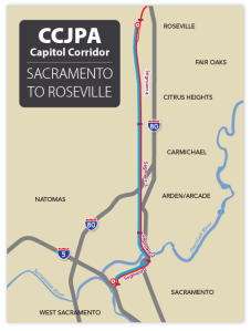
$9M to Capitol Corridor Joint Powers Authority for expanded service to Roseville and related rail improvements
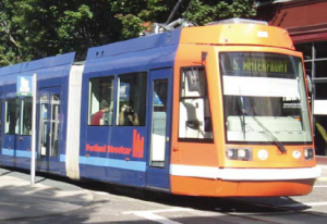
$30M to Sacramento Regional Transit District for a new streetcar
These grants of course are only a fraction of the cost of the projects, but every bit helps, and it is likely that these projects will now move forward though both were formerly stalled or moving very slowly.
From Streetsblog California, some more detail:
2. Increased Rail Service to Roseville and Rail Improvements $8,999,000 to Capitol Corridor Joint Powers Authority
The project includes:
Extending rail service to Roseville, building eight miles of a third track, a new bridge, station improvements, and more.
Creating a service optimization plan to connect with Altamont Corridor Express and Amtrak San Joaquin passenger rail services.
Adding standby electric train power to enable more trains to utilize grid electricity at the Oakland Maintenance Facility.
Capitol Corridor’s website News & Alerts page has more detail. 10. Sacramento Streetcar
$30,000,000 to Sacramento Regional Transit District
Funds go to the planned Downtown/Riverfront Sacramento-West Sacramento Streetcar (pending the project’s federal full-funding grant agreement expected by early 2017) including nineteen stations and six streetcars.
Houston has been in the news recently, and will certainly be today, opening day, for their revised transit system which created a network of high frequency (service every 15 minutes or better, 15 hours a day, 7 days a week) transit lines. The map below left shows this new system, only, and clicking goes to the high resolution image on the Houston METRO website. The map below right shows the entire system, with lines that don’t meet the high frequency definition. The system was redesigned with the help of Jarrett Walker, transit consultant and author of Human Transit, which I posted on yesterday and will be posting a lot more in the near future.


 Sacramento (highlighted dot, which is otherwise hard to find):