Shared space is a type of roadway that is common in Europe, found in a few places in the United States, and so far as I know, only one place in Sacramento. The concept is that pedestrians, bicyclist, and motor vehicles can mix without having to have set-aside areas defined by curbs and painted bike lanes.
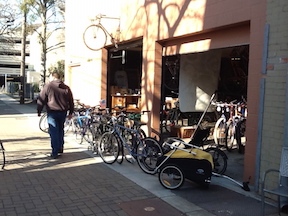
In Sacramento, Liestal Row, an alley between L Street and Capitol Avenue, and 17th Street and 18th Street, is the example. The alley was reconstructed with sidewalk areas defined by smooth concrete and roadway areas defined by bricks, however, there are no curbs in between and no limitations that keep the modes separate. The two businesses in the alley, Edible Pedal and Old Soul, spill out into the alley, and people often stand around in conversation. Often vehicles (including bicycles) have to thread their way between other users. What makes the alley work is that motor vehicle drivers are moving at a very slow speed, and do not have priority over other users. I’ve seen the uncertainty in the eyes of drivers negotiating the space, and that is exactly what makes it safe for everyone, the uncertainty that leads to paying attention instead of making assumptions or driving distracted.
The latest Strong Towns blog post is on the Strong Towns Strength Test. Ten simple questions. A Strong Town should be able to answer “yes” to each of these questions.
Here are my answers for the grid portion of Sacramento, downtown and midtown.
Take a photo of your main street at midday. Does the picture show more people than cars? I picked J Street at 16th; others might pick other streets. No, more cars than people. However, there are a few intersections in downtown and midtown that probably have more people than cars, due to state workers walking to lunch.
If there were a revolution in your town, would people instinctively know where to gather to participate? Probably yes, at Cesar Chavez Plaza, where Occupy Sacramento started.
Imagine your favorite street in town didn’t exist. Could it be built today if the construction had to follow your local rules? My favorite street is actually an alley, Liestal Row, with Edible Pedal bike shop and Old Soul coffee. It has a woonerf-like design more welcoming to pedestrians and bicyclists than cars. Unfortunately, only one block long, and there aren’t any other alleys or streets like it. Yes, I think it could be built today. In general, developers can build what they want, but if it is outside the norm, it takes a long time and a lot of money.
Is an owner of a single family home able to get permission to add a small rental unit onto their property without any real hassle? Not easily, and often not at all.
If your largest employer left town, are you confident the city would survive? In Sacramento County (much larger than midtown/downtown, but I could not find city data), the largest employer is the state (Sacramento is the state capital), followed by the county itself, then health care organizations in 3rd, 4th, 6th and 7th, followed by three school districts, and then the city itself. The largest private employer is Intel at 5th. Except for Intel, none of these are leaving town, though some or all could shrink. I don’t know what the statistics are for midtown/downtown, but since the state capitol and most government buildings are in downtown, the state would be even more prominent. One of the blog post commenters suggested that the measure should be largest industry rather than largest employer. I would answer yes, just because so many employers would not leave that a private employer would not make that much difference.
Is it safe for children to walk or bike to school and many of their other activities without adult supervision? Moderately safe, so yes. Since Sacramento City School District eliminated most of the neighborhood schools, children are now largely bused or delivered to school in parent’s cars. So a question I’d add is, are there neighborhood schools?
Are there neighborhoods where three generations of a family could reasonably find a place to live, all within walking distance of each other? Yes, in midtown, no in downtown, so somewhat.
If you wanted to eat only locally-produced food for a month, could you? Yes, if you define local as including Capay Valley and the foothill farms and ranches.
Before building or accepting new infrastructure, does the local government clearly identify how future generations will afford to maintain it? No. I’ve never heard the government even raise the issue.
Does the city government spend no more than 10% of its locally-generated revenue on debt service? The city budget of $873 million indicates that 10.8% is for debt service. However, the city has $2.1 billion in unfunded long-term debt (before the arena and any of the proposed civic projects), so if the city were actually paying down debt rather than accumulating it, the percentage would be higher than this. So, no.
Score on these ten questions = four no, one somewhat, and five yes.
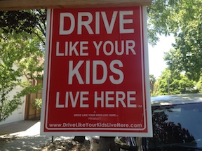
Out riding yesterday on 2nd Avenue in Sacramento, I ran across this sign, on the south side between 22nd and 23rd streets. It pretty much says it all, though I have to add – “drive like you want your kids to have a future,” which pretty much means, don’t drive at all.
Courtesy of making the Streetsblog “front page” today for the article “Stockton less sprawling than Portland or Washington DC? Not so fast,” I became aware of the blog Stockton City Limits. It’s a great site that I recommend you look at, and I’ll be delving into the site more in the coming days. The topics are similar to this Getting Around Sacramento blog, including community, development, transportation, and smart growth. Stockton is similar in many ways to Sacramento, not just because it is on a river, but it is another classic Central Valley sprawl city which has a livable core but is surrounded by unsustainable suburbs with dismal walk scores and declining economies.
The article highlights the remarkable variation in the amount of water used per capita by different areas in the region, with Granite Bay being the poster child for extensive lawns and landscaping. These exurban areas suck up the water that could be used for more productive domestic or agricultural purposes. This is not a lifestyle choice, this is extravagant misuse of our common resources. Where does this happen? Almost always in the exurbs. But many of these people still work in the urban core, their commutes eased by the freeways and arterials built with the money taken from the rest of us taxpayers. They have us coming and going. Literally.
The article highlights people who live in rural areas close to the urban core and commute to regular jobs. Another seeming lifestyle choice, made possible by the freeways and arterials that make it easy for people to live in a seeming rural paradise but work where the jobs are higher paying. They pay low property taxes, but benefit from the transportation network and other services that all of us pay for. If these people were actually serving some agricultural purpose, I’d be a lot more willing to provide some subsidy to their lifestyle, but they are only playing at agriculture, contributing nothing to the rest of us.
Several Sacramento area people have referenced the article “12 Strategies That Will Transform Your City’s Downtown” on the UrbanScale blog by John Karras. I’d like to look a little more closely at some of the strategies. If you have information or thoughts about any of these, please contribute.
#1 Turn one-way streets into two-way streets. Sacramento, and specifically downtown/midtown, has most of the one-way streets in the region. The city does have a policy to convert some of these streets, but the effort stalled, and no one seems to know why or be willing to admit why. Several streets have been resurfaced recently without being converted, though this would be the perfect time to do it. These include H, I, 9th, and 10th. There are some costs to conversion, turning signals around or installing new signals in some cases, the the reward in walkability and retail success is worth it. The post says “One-way streets are great if your only goal is to channel traffic through your downtown, but they are bad for pedestrian activity and retail opportunities. Two-way streets create a more comfortable pedestrian environment and have been shown to increase property values.” J Street in Sacramento is a classic example of how one-way streets reduce retail business. All those thousands of cars streaming by the most dense retail street in the region, and only small bubbles of successful retail to show for it. I’m glad Karras has this one on the top, because it is one of my strongest desires, with many blog posts: Two-waying streets in SF, New bike lanes, diets and sharrows downtown, street changes, more on conversion to two-way streets, and Choosing streets to walk.
dead zone on 1000 block of J Street, downtown Sacramento
Why do buildings and lots sit empty for years throughout downtown Sacramento and beyond? Because there is little consequence to the property owner of leaving them empty. They continue to pay property taxes while waiting for some development scheme that will make them so much money that the years of property tax are a drop in the bucket. Occasionally, a property is taken for non-payment of property taxes, but that is rare.
While the building or lot remains empty, the city (I’ll use “the city” for the cities and counties and utility providers) still has costs associated with the property. The cost of electrical, water, sewer, telephone, the street network, and transit in an area has more to do with the capacity of the system and the network passing by a property than the specific connection to the property, so the city still has costs even though they are receiving only a pittance of property tax. Fire and police services are actually higher for empty building and empty lots because they attract vandalism, crime, illegal occupancy. They drag down the property values of everything around them, and therefore the property tax income from everything around them. They are in large part the very definition of blight.
Ironically, many of the empty buildings and empty lots in downtown Sacramento are owned by the city itself. So the city is costing itself money by letting these sit, and of course that means that it is costing us taxpayers.
When the economy slowed, those big projects that would make a lot of money evaporated, and so more and more property sat unused. But it did not need to be unused. Smaller scale projects were always possible. I think one of the big differences between downtown and midtown in the downturn was that midtown had a large number of small properties owned by people with moderate dreams of development and redevelopment, while downtown had a few large properties owned by people with grandiose dreams. Those dreams crashed, and so did downtown. A number of successful businesses were dragged down by the failures around them. Midtown went through a slow time, but lost far fewer businesses, and is now picking up in a way that downtown has not.
So, what to do? As always, I have some outside-the-box (or off-the-wall, some would say) solutions to propose.
1. Assess property tax on all government entities. What purpose would this serve? Wouldn’t it just be moving money from one pocket to another? Yes, but it would make the cost of maintaining empty buildings and empty lots show up on the balance sheet as a direct expense. As with all things financial, we pay it no attention until it shows up on the balance sheet and affects the bottom line.
2. Assess empty lots at the value they would have if developed, based on typical properties surrounding it. Seems unfair? Not in my mind. The empty lot is costing the city, and all of us, directly in terms of services needed, and indirectly in creating blight that lowers property values and depresses economic activity. This higher level of property tax would encourage the owner to move forward with development. In a few instances, these empty lots could be converted to public purpose such as a park or farmers market location, but the number of those conversions would be small relative to the number of properties
3. Double property taxes every four years for both empty lots and empty buildings. This would give the owner a strong incentive to do something. While regular property taxes can largely be ignored, when it goes up 2X, then 4X, then 8X, then 16X, no property owner will leave the property unused.
I have no illusions that even these radical proposals would bring vibrancy back to downtown, but along with many other policies and actions, they would certainly help.
I think something needs to be done about surface parking lots, which are another unproductive use of land that costs us all money, but that is another topic for later.
I’ve uploaded a few photos to Flickr of abandoned downtown, along J and K streets. It would take days and thousands of photos to document it all.
Walk Score offers an assessment of the walkability of any location. It is available in any browser at https://www.redfin.com/how-walk-score-works. The Redfin app shows walk score, bike score and transit score for each listing (scroll way down). Walk Score is based on the distance to the places people want to go, such as grocery stores, restaurants, coffee shops, bars, movie theaters, schools, parks, libraries, bookstores, fitness locations, drug stores, hardware stores, and clothing & music.
WalkScore has released for Sacramento a new walk score, 43, transit score, 33, and bike score, 68. New York is the top walk score city at 92, followed by San Francisco, Boston, Philadelphia and Miami. New York is the top transit score city at 81, followed by Boston, San Francisco, Washington DC, and Philadelphia. Portland is the top bike score city at 70, followed by San Francisco, Denver, Philadelphia and Boston. Sacramento compares very well in bike score, at 68, but poorly in walk score and transit score.
For the Sacramento region, walk scores in various neighborhoods range from 5 to 92 (of 100), transit scores range from 11 to 65, and bike scores range from 38 to 100. In general, the scores track with each other, walk friendly = transit friendly = bike friendly, however, there are exceptions. You can look up your neighborhood on the chart linked below, or go to WalkScore for a lot more detail on Sacramento. The top five neighborhoods are Boulevard Park, Downtown, Midtown/Winn Park/Capital Avenue, Marshall School and Mansions Flats, all in the city of Sacramento. WalkScore exists largely as a sales tool for houses and apartments, but it has broad applicability as well.
“Not all economic development is created equal. Not all local investments build wealth in our community. Not all open markets produce optimal outcomes for all places. If we want our places to prosper over time, we have to be prepared to ask a tougher set of questions at the local level.” Charles Marohn, in Dunkin Our Future, on Strong Towns blog
sactown magazine has an interesting series of articles grouped under Why Not Here? which I like for its thinking outside the box. Though most of these are not directly transportation related, they are about transforming the nature of Sacramento and bringing residents into downtown. Most of the articles were written by sactown co-owner Rob Turner.
I believe that these are important goals because it is only through dream-big projects that the money to fix our transportation woes will become available. If we have to wait until our regular tax base can fix things, we will be waiting a long time, but new developments can fix things as part of their design. Several ideas are about bringing regular and high-end housing to downtown, which encourages walking, biking and transit solutions rather than more driving and more parking.
Return of the JFDI (sactown 2013-12); this one is about the Community Center Theatre