SACOG in the 2013 funding round allocated $9M to the Riverfront Reconnection project in the City of Sacramento. This phase extends 2nd Street from Old Sacramento to Capitol Mall, providing an easier access to Old Sacramento, and also adds sidewalks to O Street and improves sidewalks and bike lanes on Capitol Mall between 3rd Street and the Tower Bridge. The overall purpose is to create or restore connections between downtown Sacramento and Old Sacramento which were severed by Interstate 5.
William Burg started a wonderful conversation on Facebook about removing Business 80 from B Street to Hwy 50, returning the traffic to surface streets. The post is now up to 115 comments, and still going after two weeks. I believe that you have to be a member of Facebook to view this thread, but don’t need to be friends with William Burg (though you should). I agree with Jared that this topic should be amplified for Sacramento Press.
Some people think that this is crazy thinking, it will never happen. I think it will. Why? Not because it is a good idea, though it is, but because we will not be able to continue to keep these freeways open and in decent condition with future transportation funding. Caltrans and others have just spent or are spending $202 million on Hwy 50, basically just to keep in it usable condition. Not to improve it in any significant way, but just to keep it working. Where is the money going to come from to maintain Hwy 50, Interstate 80, Interstate 5, and Business 80 (Capital City Expressway)?
A “green wave” is a traffic signal sequence set so that vehicles will encounter green lights for some distance, so long as they are traveling at the selected speed. A green wave can also be set for bicycle speeds, though it very rarely has been, and never in Sacramento.
To some degree, all signals are set this way, though the degree and distance of sequencing varies widely. Many of the east-west streets in the Sacramento grid have signals set for motor vehicles, and when traffic is not congested, it may be possible to go all the way across downtown and midtown on green lights, for example on J Street. Very few north-south streets are set this way, I can think of only the 15th & 16th couplet, and the 9th & 10th couplet. At intersections with the east-west couplets, these north-south couplets seem to have their green wave broken. Only if the grid spacing and the selected speed calculate out is it possible to have a green wave in all directions. Sadly, many signal sequences in the Sacramento region are set above the posted speed limit, encouraging drivers to speed so that they make all lights.
Thank you, Elle, for reminding me in your “transportation ‘planning’ downtown” that I wanted to write about I Street. Note: If you are looking at Google Maps, it does not show the current lane configuration on I Street since the repaving and re-striping project of last fall, nor the realignment of tracks and work on extending 5th and 6th streets over the tracks.
I Street from the 4th Street crosswalk; I have the walk signal but this is still scary
I Street in Sacramento approaching the train station is a mess. Starting with the confusing floating bike lane between 7th and 6th streets (subject of a future post), the street becomes worse and worse: five lanes wide, high speed, and completely unfriendly to bicyclists and pedestrians. For pedestrians, the crossing on the east side of the I/5th intersection is uncomfortable because westbound traffic is already moving at high speed and often runs the red light, and right turning cars from I to 5th often do not yield to pedestrians in the crosswalk. The west side is so unsafe due to traffic turning left off 5th Street, it is signed against pedestrian crossing, even though this is a logical walking route from downtown to the train station. A crosswalk has been added on the east side of the I/4th intersection, but it has the same challenges that drivers are moving too fast and often run the run light. When I used this new crosswalk, I was very concerned, and I have a much higher tolerance for danger than most people do.
The right-most two travel lanes lead to the high-speed northbound I-5 freeway onramp, so drivers passing 6th Street are already accelerating to freeway speeds, many times going 55 mph as they cross through the I/5th intersection. The next two lanes lead to a medium speed onramp to the I Street bridge over the Sacramento river, and to the southbound I-5 onramp. For pedestrians, the only way to go westbound towards Old Sacramento is to go through the parking lot for the train station and under the onramps along an ugly, dark, poorly marked pedestrian way.
Nine posts (linked below) have outlined my thoughts about how to create a livable, walkable, bikeable and safe downtown/midtown Sacramento. These have been nearly all from a transportation perspective, how we change the way people get around. Though I will continue to post on these topics, I want to wrap up for the moment. I need to pay attention to some other things, and I need to finish my taxes!
Livability is not created merely by transportation changes – it takes a lot more than that. But it does provide fertile ground for the changes that are needed. I am pleased to know of and be a small part of efforts to transform downtown/midtown. I attended CivicMeet Sacramento on Wednesday, where the participant selected topics were save the bikes (bike theft), rooftop utilization, fresh fruit and veggies downtown, and human capital clearinghouse. I attended the Turn Downtown Around open forum two weeks ago. Good energy from (mostly) young people, directed towards creative solutions to making downtown/midtown a vibrant place. I’m sure there are many others working towards the same ends (many ends). It is sad that the city government is trailing, slowly, rather than leading, but it also an opportunity for creatives to step in and fill the gap.
Let me acknowledge that transportation is only a small part of the big picture, but I write about it because it is my small part.
Sometimes I catch a ride from a friend or take an Amtrak bus, and am on freeways in the Sacramento area, which most of the time I never see. I wonder why there are so many lanes for so few cars, so much expanse of empty concrete and expensive bridges. Of course I know the answer, the freeways have been built for two rush hours, morning and afternoon, on five days a week, perhaps 13 hours per week out of 168 hours in the week. Oh, and the Friday up to the snow or Tahoe and Sunday back home, that weekly migration of bay area people. The rest of the time they are largely empty.
Yet freeways take up a huge amount of space, have a huge carbon footprint for construction and maintenance even before fuel consumption comes into play, spew pollution into neighborhoods, and suck up the largest portion of our transportation funds. As an example of cost, the nine miles of the six-lane Capitol City Freeway (Business I-80) from Interstate 80 to Highway 50 is 54 lane-miles. Though the cost to construct a lane-mile varies widely, from $2M to $80 million, lets take a very conservative number of $5M and say that this section of freeway cost a quarter of a billion dollars. And this is not even an expensive highway, with its simple interchanges. Pretty amazing, huh? What else could we have done with that money?
A friend suggested that my streets change ideas were hardly new, and that is quite true. Some streets were converted in the past, some were identified for conversion but not completed, and many more have been suggested but not adopted by the city. Here are some additional references.
Some news articles about past and planned conversions in Sacramento:
Note: There are a number of contrarian views available from the cars-first crowd. You can search for the Internet for “two-way conversion” if you want to find them.
The maps I posted the last two days were preliminary to this post. I would like to see two significant changes to the streets in downtown/midtown Sacramento that will make these areas more livable, more walkable, more bikeable, and safer. I am proposing the complete elimination of traffic sewers from downtown/midtown Sacramento. What is a traffic sewer? It is a street designed to move large volumes of vehicles at high speed in and out of work areas during morning and afternoon commute times. In Sacramento, the main work area is the state buildings downtown, though there are certainly other employers and other areas, including midtown.
3 to 2 conversion, 10th Street northbound
1. Convert all three-lane streets into two-lane streets. The map showing these streets in the downtown/midtown area is linked from my Sac 3-lane Streets post.
These three-lane streets are, of course, also one-way streets. In many cases the lane removed would be used to provide bike lanes or protected bikeways, but in some cases the space might be best used to create wider sidewalks or diagonal parking where additional parking is needed. Though in some cities the three-lane to two-lane conversion is used to create a turning lane, I don’t believe that these are necessary in downtown/midtown, nor do I feel that this is a good investment of right-of-way.
This conversion would remove some traffic capacity, though unfortunately, not as much as one might wish. Studies show only a slight reduction in capacity from this treatment, which is sometimes referred to as a road diet, though I like the term rightsizing.Read More »
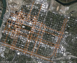
At right is the second map of downtown/midtown Sacramento, showing the 1-way streets. This map was created using Google maps and memory, and has not yet been field checked.
These streets total about 32.6 miles.
The map graphic links to the map data in Google Maps, from which you can zoom in on areas and turn on or off satellite view. The reason that this is not a map view graphic is that the online browser version of Google Maps starts paging after about 18 entries, so it is not possible to view all of the segments at the same time. This image is instead from Google Earth, via KML export and import.
The map provides background for an upcoming post about transforming transportation and livability in downtown/midtown.