Marysville Blvd VZ Safety Project starts

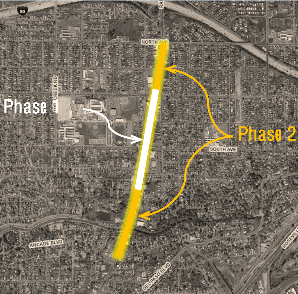
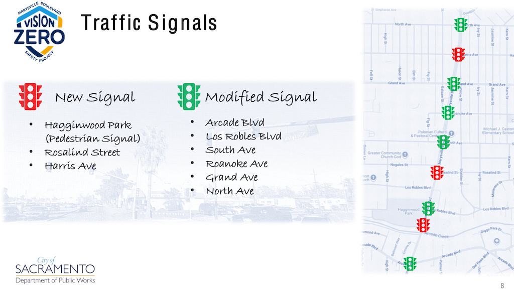
The Marysville Blvd Vision Zero Safety Project, Quick Build Phase 1, started today, Monday, March 16. The overview from the SacATC presentation on September 18, 2025, shows Phase 1, which is from Grand Avenue to Nogales Avenue only. Phase 2 will cover from North Avenue to Arcade Blvd. Phase 2 will include more extensive work, but is not being called a ‘complete streets’ project. Only Phase 1 is fully funded. The city has in the past applied for grants to convert the entire stretch of Marysville Blvd into a complete street, but has been unsuccessful in that effort, which has led to this quick build project in order to improve safety now rather than someday. Phase 1 will cost $1.4M and be completed in 2026. Phase 2 is about $18M and only partially funded.

map of Marysville Blvd Phase 1 and Phase 2
Marysville Blvd Phase 1 and Phase 2

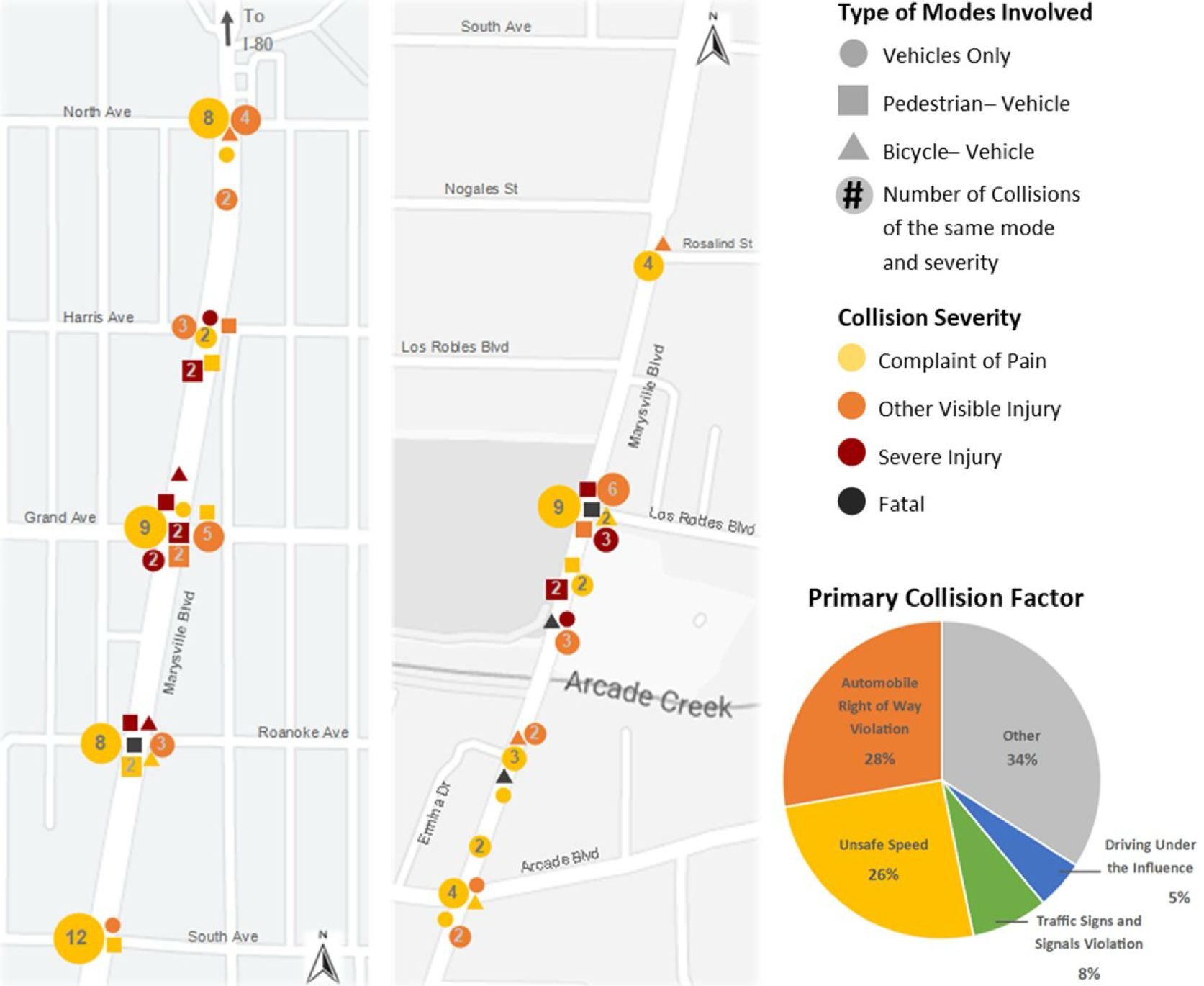
A diagram from the SacATC presentation September 18, 2025, shows collision history for the segment. This is the issue that the city if trying to solve. The diagram is rather dense with information, but of note is that of the four fatalities, three are outside the current phase, and only one is inside, at Roanoke Aveue.

diagram of Marysville Blvd collision history
Marysville Blvd collision history
Read more: Marysville Blvd VZ Safety Project starts

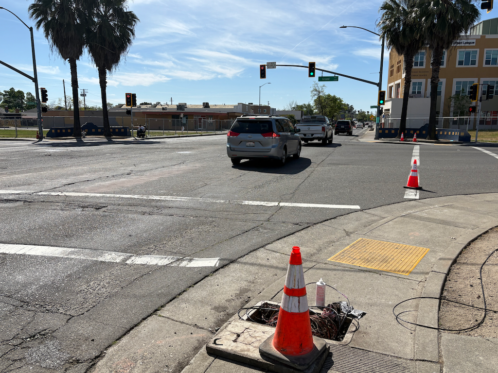
Marysville Blvd is narrowed for construction to one lane, starting just south of Harris Avenue and continuing to south of Roanoke Avenue. During my time of observation, I did not observe any significant backup of traffic, however, it was mid-day, not commute hours.

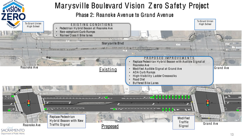
The work on this day is focused on the intersection of Marysville Blvd and Grand Avenue. Signal wiring at the intersection has been exposed and torn up, in preparation for installing a modified signal at this intersection. The diagram from the SacATC presentation on September 18, 2025 (below), shows a modified signal at Marysville and Grand. It is hard to reconcile the signal wiring being torn out with the term ‘modified signal’, but no other information is available.

photo of Marysville at Grand Ave, construction and signal upgrade
Marysville at Grand Ave, construction and signal upgrade
diagram of Marysville Blvd new and modified traffic signals
Marysville Blvd new and modified traffic signals

The SacATC presentation on September 18, 2025, includes existing and new for the section from Roanoke Avenue to Grand Avenue, and shows a complete rebuild of the intersection, but this is Phase 2, and it isn’t clear what the intersection and signal will look like at the end of Phase 1. Though the wording is not clear, the pedestrian hybrid signal (HAWK) at Roanoke Avenue may be completely replaced with a new regular traffic signal, but again, in Phase 2. I will have another post on Phase 2, but this one is focused on the Phase 1 Quick Build.

Future post will follow the construction project, and look more closely at Phase 2.

So far as I can determine from the presentation diagrams and the plan diagrams, no sidewalk improvements other than ADA ramps at intersections are planned. Though there are sidewalks nearly throughout the segment, they are narrow and unbuffered. The majority of the driveways ramps are sloped, many to such as degree that they present a barrier to wheelchair travel.

Sadly, most of this segment of Marysville Blvd is characterized by closed businesses, long abandoned buildings, and empty lots. This is not to denigrate the existing businesses, health services, and parks, but it will take much more than this project to energize this corridor. This is an area that has been disinvested by the City of Sacramento since it became part of the city, and it shows. A Marysville and Del Paso ‘Forward Together’ Action Plan lays out some of the actions necessary to heal this community.

Stockton BRT alternative alignment

For additional posts on Stockton Blvd, both the current STEP project and earlier iterations, see category: StocktonBlvd.

Part of the Stockton Boulevard Safety and Transit Enhancement Project (STEP) is consideration of changing the BRT (bus rapid transit) route north of Broadway to part of SacRT Route 38. In a presentation at the STEP stakeholder meeting on February 19, and in the similar presentation to SacATC on March 12, this alternative was presented by a slide (page 7) and additional discussion. That slide is below, followed by a slightly more detailed Alternative 2 – Route 51/38 Hybrid Alignment.

STEP BRT Route Alternatives, from SacATC presentation
STEP Alternative 2 Route 51/38 Hybrid Alignment

At SacATC, Commissioner David Moore raised the issue that the existing Route 51 along Broadway is also a very high ridership corridor, serving to connect equity neighborhoods to downtown and to Stockton. Replacing Route 51 high-frequency (15 minute) service with a moderate-frequency (30 minute) route, as Route 38 currently is, would be a disservice to these riders and raise major equity issues.

The segment of Broadway from Stockton Blvd to 8th/9th Streets, and probably into downtown, MUST have high-frequency (15 minute) service.

The two existing routes, 51 with a high-frequency (in SacRT terms, though this would be considered moderate frequency in major cities), and 38 with a moderate-frequency, are shown below (pdf).

map of SacRT Routes 51 and 38 existing
SacRT Routes 51 and 38 existing

Though it is not stated anywhere, the STEP alternative 2 map implies that the BRT route would end at Sacramento Valley Station rather than 8th St & F St as Route 51 currently does.

The western part of Route 38, which would become Stockton BRT under the alternative 2 51-38 hybrid, follows Stockton from Broadway north to T Street, then northbound on 30th Street or southbound on 29th Street, then west on L Street or east on J Street, and thence to Sacramento Valley Station.

map of SacRT Route 38 west segment, potential Stockton BRT
SacRT Route 38 west segment, potential Stockton BRT

The west portion of the existing Route 51, from Stockton Blvd to 8th/9th Streets, is the segment that must have high-frequency (15 minute) to continue to serve the present high ridership. It is possible that this route would terminate at Sacramento Valley Station as well. It is unknown whether ridership on the existing Route 38 to the east, terminating at 65th Street light rail station, would also justify high-frequency service, and whether it this would be combined with existing Route 51 west. Map below (pdf).

map of SacRT Route 51, west segment, from Stockton Blvd to downtown
SacRT Route 51, west segment, from Stockton Blvd to downtown

SacATC 2026-03-12: T St Bikeway comments

I will make comments at SacATC tonight on the T Street Bikeway Gap closure project.

  1. This should be called an active transportation project. There are pedestrian improvements as well as bicyclist improvements, which is appropriate.
  2. Overall, the project addresses several known safety issues, but could be improved. The modification of Gerber Ave is appreciated.
  3. As unsafe as bicycling is through the Stockton Blvd/T Street intersection, crossing of Stockton in the south crosswalk is even more unsafe. This crosswalk must be made safe for walkers by the addition of a long leading pedestrian interval (LPI), a minimum of 8 seconds, or an exclusive pedestrian phase.
  4. The diagram seems to show the T Street eastbound bike lane at Stockton to the right of an optional right-turn lane. The diagram indicates ‘modify traffic signal’ but does not show a bicycle signal face. Unless there is an exclusive bicycle phase for at least a part of the overall signal cycle, this is unacceptably dangerous for bicyclists.
  5. Removal of the intersection setback on T Street eastbound is good, but will require a ‘no right turn on red’ sign or blank-out sign.
  6. No RRFBs! They are not safe in the City of Sacramento due to driver non-compliance.
  7. The presentation does not make it clear why the Stockton Blvd Corridor Plan recommendation to change eastbound T Street at Stockton Blvd to a single through lane was dropped. This change would greatly simplify the intersection for walkers, bicyclists, and drivers, and remove the need for a merge east of Stockton Blvd.
  8. Caltrans should be forced to add additional lighting, which was neglected during the Fix 50 project, where 34th Street and T Street pass under Hwy 50. This should not be a city responsibility.
diagram of T St & Stockton intersection
T St & Stockton intersection diagram, from the presentation

opening Land Park roads to people

The City of Sacramento is considering closing two streets in William Land Park to cars in order to open them to people. The SacBee article has more details: City could test closing streets in Sacramento’s William Land Park. The article does not have a map, so I created one, below. This is my best guess from the text description in the SacBee article. I have not found any other documents on this proposal.

Note that the terminology ‘closing’ is not the one used by active transportation advocates. The preferred term is ‘opening’, because the road, formerly used mostly by motor vehicles, with concomitant danger to those not in a motor vehicle, is now open to walkers and bicyclists.

I wrote, way back in 2022, about my suggestion for closing roads in William Land Park to motor vehicles (Land Park open (car free) roads?). This new proposal does not match mine, but it is a good proposal. At this time, only a very small roadway and gate at the far southeast corner of the park is closed to motor vehicles.

William Land Park is dominated by motor vehicles, so any ‘closing’ / ‘opening’ is welcome. This is a good first step. Parks are for people, not for cars.

Land Park pilot road 'closure'

SacCity intersection improvements

Sacramento City Express newsletter of March 4 includes an item about improvements to four intersections with a grant from the federal HSIP (Highway Safety Improvement Program) program. The article is below.

This is not part of the city’s new quick build program, rather it is from a grant submitted some time ago. Though( the city is not planning for or applying for new RRFB (Rapid Rectangular Flashing Beacon) installations, they were specified in this grant application and will be installed.


Safety upgrades coming to four high-injury intersections across Sacramento

Pedestrians crossing some of Sacramento’s busiest corridors will soon see brighter warning beacons, clearer markings and improved accessibility features designed to make walking safer and more accessible.

The Sacramento City Council this week approved the Highway Safety Improvement Program (HSIP)-10 Pedestrian Crossings Improvement Project, which will enhance crossings at:

  • Folsom Boulevard and Seville Way
  • Raley Boulevard and Santa Ana Avenue
  • W Street and 8th Street
  • Alhambra Boulevard and X Street

All four intersections are located on arterial roadways identified on the City’s High Injury Network in the Vision Zero Action Plan, which focuses on reducing traffic fatalities and serious injuries on City streets.

The project includes installation of Rectangular Rapid Flashing Beacon systems at each location, upgraded curb ramps with detectable warning surfaces, new signage, flexible posts and refreshed striping and pavement markings to improve driver awareness and pedestrian accessibility. Rectangular Rapid Flashing Beacons are pedestrian-activated flashing yellow lights that alert drivers someone is crossing the street.

“These intersections are on our High Injury Network, and additional visibility and warning features are designed to improve driver awareness to yield to pedestrians,” said James Kragh, associate engineer with the Department of Public Works. “Installing rapid flashing beacons and upgrading curb ramps will enhance conspicuity and accessibility for people using these crossings.”

The City applied for and received $193,600 in HSIP Cycle 10 construction funding to help deliver the project.

Construction is expected to begin later this month and be completed this summer.

Once complete, the upgraded crossings will provide stronger visual cues to drivers and safer, more accessible routes for people walking and rolling along some of Sacramento’s most heavily traveled corridors.

SacATC 2026-03-12

SacBee 2026-03-11, Madison Smalstig: What changes could come to Sacramento’s dangerous Fruitridge Road corridor?

The City of Sacramento Active Transportation Commission (SacATC) will meet this Thursday, March 12, starting at 5:30 PM. This is not the usual third Thursday, but the second. The meeting may be held in the old city hall, rather than council chambers, but the agenda is not clear about that.

The agenda is below (pdf). I have not had a chance to look at the four agenda items to make comments here, but will if I am able. The linked items contain both staff reports and presentations. I find it useful to separate these into two documents, but again, only if I have the time. All of these are review and comment items, not for decision.

I have written about Stockton Boulevard Safety and Transit Enhancement Project (STEP) previously, but am not sure if the presentation will be the same as the stakeholder workshop.


Agenda

  1. Fruitridge Road Safety and Mobility Plan: staff report | presentation
  2. Arden-Auburn Mobility Plan: staff report | presentation
  3. Stockton Boulevard Safety and Transit Enhancement Project: staff report | presentation
  4. T Street Bikeway Gap Closure Project: staff report | presentation
graphic of Fruitridge Rd collisions
Fruitridge Rd collisions

SacATC annual report to budget committee tomorrow

The City of Sacramento Budget and Audit Committee will consider the recommendations of SacATC (Sacramento Active Transportation Commission tomorrow, Tuesday, March 10. The commission is asking that the city invest in implementing the recommendations of the report. Though Sacramento seeks grants to improve street safety, that process is slow and not always successful. The city’s new quick-build program is a first step forward, but not yet active. We cannot afford to wait while people die and are severely injured on our streets.

The email from Slow Down Sacramento/Isaac Gonzalez is included below, and has all the information you need.

On Tuesday at 11:00 a.m., the Sacramento City Council’s Budget and Audit Committee will consider recommendations from the Active Transportation Commission’s 2025 Annual Report. These recommendations focus on funding practical steps that would make Sacramento’s streets safer for people walking, biking, and rolling.


You can view the report for yourself by clicking here.


The commission is asking the City to invest in proven safety strategies, such as expanding traffic-calming tools, strengthening the city’s quick-build program, developing a citywide Safe Routes to School effort, and implementing safety improvements, such as Leading Pedestrian Intervals at traffic signals. These are not abstract ideas. They are practical tools that cities across the country are using to reduce serious injuries and save lives. 
Right now, none of these recommendations have identified funding attached to them. That means the Budget Committee will play an important role in deciding whether these ideas move forward or remain just another report sitting on a shelf.


If you care about safer streets in Sacramento, this is a moment where public voices matter.


Two ways you can help
1. Submit an e-comment
Take a few minutes to tell the committee that you support funding the Active Transportation Commission’s recommendations. Personal stories about safety in your neighborhood are especially powerful. The agenda item is #6.
2. Speak in person
You can also attend the meeting and provide public comment.


Budget and Audit Committee
Tuesday at 11:00 a.m.
Sacramento City Hall
915 I Street


Even a brief statement reminding decision-makers that street safety matters to Sacramento residents can make a difference.

Why this matters
Sacramento has declared a Vision Zero goal of eliminating traffic deaths, yet serious injuries and fatalities continue to rise. The Active Transportation Commission’s recommendations outline practical steps the City can take now to address dangerous streets and protect people who simply want to move through their neighborhoods safely.
Plans alone do not save lives.
Investment and action do.


If you are able, please submit a comment or come to City Hall on Tuesday and speak up for safer streets.
Thank you for continuing to stand with us.

H Street Bikeway: workshop

For other posts on the H Street Bikeway project, see category: H Street Bikeway. For the city webpage on the project, see H Street Bikeway to Sacramento Valley Station.

A workshop on the H Street Bikeway was held Thursday, February 26. There were at least 30 members of the public who attended, which is pleasantly surprising, indicating strong public interest in the project. Most workshops have far less participation.

The group presentation was brief. Most of the discussion was with city staff and consultants at the display boards. There were some renderings which I had not seen before, below. None of these three is the same as the rendering shown at the top of the project page.

I did not capture the display boards showing each block segment. They are very similar to the ones presented at the SacATC meeting, but some corrections and enhancements were made after feedback from that meeting. Among them:

  • A 10 foot width will be maintained throughout the project, except 9th to 10th Streets, where the bikeway is at the level of and within a pedestrian area, where a narrowing may help maintain lower bicyclist speeds.
  • Every intersection will have bicycle signal faces; this was an oversight in the images.
  • An alternative was proposed for 10th Street, narrowing the east side parking in order to create a buffer on both sides of the bike lane. The option to place the bikeway against the curb, for parking protection, was much discussed but is so far not the option being presented.
  • The StreetMix cross-sections now show widths.
  • The consultants will consider the driveway speed bumps that I proposed: H Street Bikeway: driveway speed bumps.

There are other details. Hopefully the brief presentation and the updated images and cross-sections will be posted to the webpage.

A lot of discussion between the public and the staff and consultants revolved around the issue that a clear design criteria was the preservation of parking. The lead consultant, Mr. Wright, mentioned a number of times how they had managed to preserve parking. This is sad. The purpose of the TIRCP grant is to enhance transit and active transportation access to the station. Preservation of parking is not one of the criteria. I don’t object to street parking. It has the safety problem of vehicles entering and leaving, but also has the safety benefit of slowing traffic due to the perceived friction. However, when roadway width is needed for other purposes, such as sidewalks and bikeways, it should be removed or reduced.

The primary reason for the right turn lanes at 7th Street and 9th Street is so that bicyclist can move while the straight through motor vehicle traffic is moving, but not when right turns are prohibited. The city feels that creating an exclusive bicyclist phase, where only bicyclists are moving and motor vehicles are stopped in all directions, would slow traffic too much.

For these two right turn situations, blank-out no right turn signs will be used. The city recognizes that regular no right turn on red signs don’t have much effect on driver behavior, but the blank-outs do. See no turn on red for Sacramento? for more info on blank-out signs. One is installed on Broadway at Land Park Drive (more on Broadway-Land Park bike signal).

To everyone who came, asking questions and providing opinions and experiences, thank you! Improvements may be incremental, but without you, they would be none.

H Street Bikeway: 10th St alternative

For other posts on the H Street Bikeway project, see category: H Street Bikeway. For the city webpage on the project, see H Street Bikeway to Sacramento Valley Station.

The 30% design for the 10th Street connection to the H Street Bikeway is shown below (these were also in the overview post H Street Bikeway: overview). The overall width of the roadway is 105.5 feet, and the ‘FOC face of curb’ width is 50 feet. The street narrows to 34 feet at the curb extensions at I Street and H Street.

H St Bikeway 10th St section, proposed
H St Bikeway 10th St section, proposed (from SacATC presentation)
H St Bikeway 10th St section proposed
H St Bikeway, 10th St section, proposed, 105.5 feet (from SacATC staff report)

I have created a StreetMix cross-section duplicating the design cross-section so that it can be compared to an alternative recommendation.

H St Bikeway, 10th St cross-section, proposed
H St Bikeway, 10th St cross-section, proposed (StreetMix created by Dan Allison)

The design proposes a 7 foot bike lane northbound, with a 3 foot stripped buffer, and a parking lane to the right against the curb. Despite the cross-section showing a vertical delineator in the buffer, this is not possible with a parking lane to the right of the bike lane. The bike lane continues the separated, mostly parking-protected, bikeway from the south, which is a good thing. But a buffered bike lane is less safe than a separated bike lane, so detracts from the safety and low-stress goals of the project. The design encourages drivers, whether parking or drop-off/pick-up, to cross the bike lane, a poor practice.

Instead, the design should create a parking-protected separated bikeway. This reduces the utility for drop-off/pick-up, but an larger area could be set aside in the parking lane for this purpose, and the conflict zone crossing the bikeway can be clearly marked. Bikeways that swing into the curb past curb extension, and out again past curb extension, feel awkward for bicyclists, but they have been installed in several locations along the separated bikeway network, and don’t seem to engender safety issues.

The design also proposes sharrows within a southbound general purpose lane. You will have to look closely at the image to see the sharrows, but there are there. They are placed far to the right, in the door zone. This is a very poor design. New sharrows should not be installed, as they don’t decrease crash risk over unmarked routes. If they were there, they should be placed in the exact middle of the travel lane, and supplemented by ‘bicycles allowed use of full lane’ signing (MUTCD R9-20). to make is clear that drivers should not be passing bicyclists in this block. It is particularly likely that drivers will squeeze out bicyclists against the curb extension at I Street. An alternative is to stripe a narrow 5 foot bike lane, without buffer or protection, marked with green. Not ideal, but better than sharrows.

The design retains existing parking. Though it is not clear that removing parking would allow a better design, this should always be a consideration. There is ample and never-full parking in the city garage on the south side of I Street between 11th and 10th Streets. The curb extensions at I Street and H Street are critical features for the safety of walkers, but they do constrain design in this block.

My suggested design is below.

H St Bikeway, 10th St cross-section, alternative design
H St Bikeway, 10th St cross-section, alternative design (StreetMix created by Dan Allison)

I do not have the time it would take to create an image of the street with the new design, but I think the cross-section will communicate clearly enough.

What is different? A southbound traditional bike lane (Class II) has been added. Both general purpose lanes have been reduced to 10 feet. There is no reason for over-wide lanes in this section. No buses, no delivery. The east side parking lane, an over-generous 9 feet, has been reduced to 7.5 feet. And the parking-protected separated bikeway is up against the curb, still with a 3 foot buffer from parked cars.

H Street Bikeway: a glaring gap

For other posts on the H Street Bikeway project, see category: H Street Bikeway. For the city webpage on the project, see H Street Bikeway to Sacramento Valley Station.

The H Street Bikeway project extends from 5th Street to 10th Street along H Street, and along 10th Street from I Street to H Street. It is intended to improve transit connectivity by double-tracking two blocks of light rail between 5th Street and 7th Street, and to improve bicycle access by providing a two-way separated bikeway (cycle-track) on H Street, which links to bikeways or bike lanes on 9th Street (southbound) and 10th Street (northbound). The project provides a reasonable solution, though it could be improved in a number of details (see H Street Bikeway: overview).

A map in the SacATC presentation shows the bikeway network in the central city, highlighting the gap on 10th Street from I Street to H Street.

map of Preferred Bicycle Network, showing gap on 10th St between I St and H St
Preferred Bicycle Network, showing gap on 10th St between I St and H St (from SacATC presentation)

It does not highlight the glaring gap on I Street between 12th Street and 10th Street. The separated, parking-protected bikeway on I Street, that starts at 21st Street, ends at 12th Street (it is just a bike lane in front of the fire department just west of 13th Street, but resumes further west).

For a bicyclist wanting to access the proposed two-way separated bikeway on H Street, they must use regular Class II (paint only) bike lanes from 12th Street to 10th Street, then proceed north one block in a buffered bike lane to H Street. I Street between 12th Street and 10th Street is three general purpose lanes. As it typical of any three-lane one-way street, motor vehicle speeds are well above the posted speed limit of 25 mph, except when congested. By the way, it is not posted at all in this section, though the change from two lanes to three lanes at 12th Street would make posting logical if not imperative.

There are other gaps, including 9th Street south of Q Street, and L Street and N Street. The map refers to a L & N Street Bikeways Project, but neither the planning or engineering sections of Public Works seem to have a webpage on that project. Strangely, the streets adjacent to Capitol Park are shown as Class II, paint only bike lanes, though these two sections without mid-block driveways are the most logical place for separated bikeways in the entire city.

The map from the H Street Bikeway project presentation at SacATC was adapted from an old Grid 3.0 map (2016), below.

map of central city preferred bicycle network
Grid 3.0 map of central city preferred bicycle network

A more up-to-date map, with legend, is in the Streets for People Active Transportation Plan, page 80, ‘Figure 30 – Recommendations for People Biking in Central West Sacramento’, excerpted below. This map shows a separated bikeway (purple) continuing from 21st Street to 9th Street.