A post today on Streetsblog LA (Santa Monica’s New 17th Street Curb-Protected Bike Lanes are Amazing) is about new bicycle facilities on 17th Street in Santa Monica. I think you will find some of the photos interesting. At first glance, it looks like some of the ones being installed as part of the Central City Mobility Project, but looking more closely, two differences really stand out. Most of the separated bikeways in Santa Monica are curb-protected. Bikeways that are solely parking protected only are protected when cars are parked. Otherwise, they are really just buffered bike lanes. And the turn wedges are hard curbs with additional markers, not paint-only, and definitely superior to the Sacramento’s suggested turn wedges which might have vertical delineators or other markers, but won’t have curbs.
curb turn wedges in Santa Monica (from Streetsblog LA)
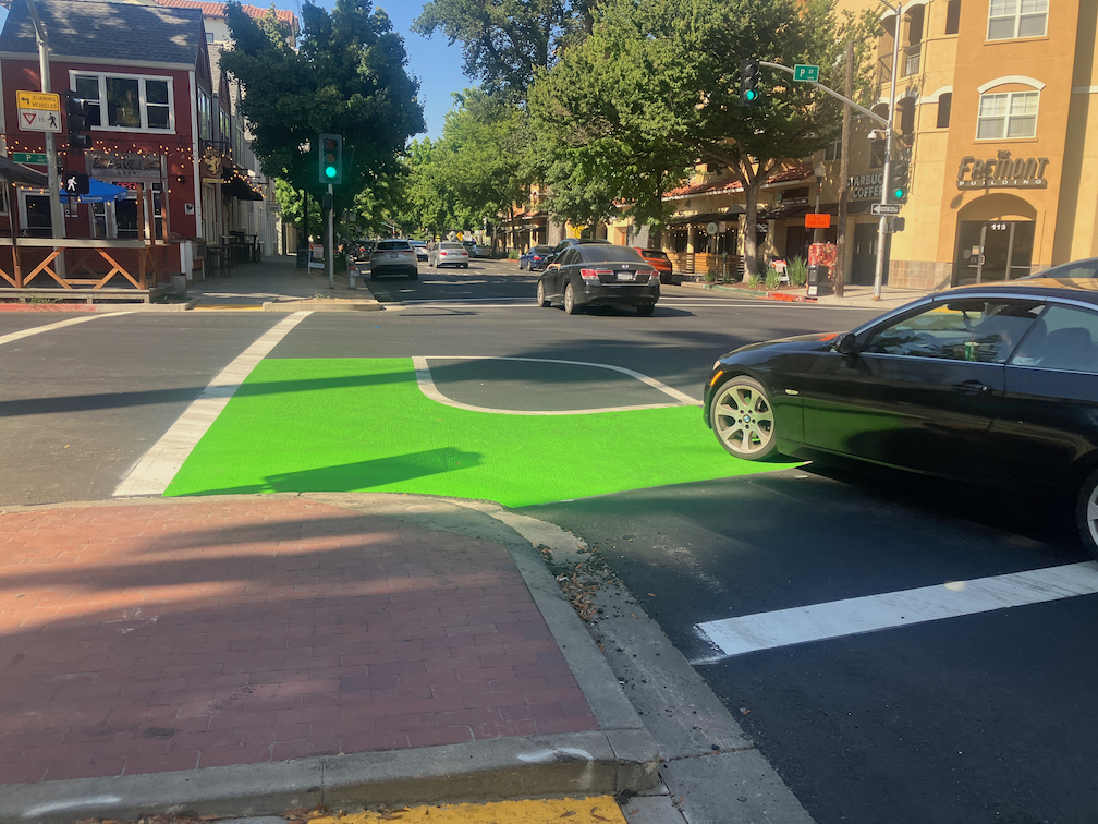
To illustrate the problem these curb turn wedges solve, see the photo below of a motor vehicle making a high speed dangerous turn over a painted parking wedge at P Street and 15th Street.
16th St & P St, Sacramento, high speed turn across painted turn wedge
Other
P Street markings including green paint are nearly complete. In two blocks, the green paint is nearly the entire block, for unknown reasons. There is nothing unique about these blocks. While green paint is useful to mark conflict areas, excessive use will just lead to maintenance expense over time.
Q Street has preliminary markings, but the temporary lane tabs still indicate overly wide and dangerous general purpose lanes.
19th Street is nearly complete from H Street to Q Street, but there is no marking south of Q Street. South of Q Street, the old bike lanes show in some places, but otherwise have been erased in favor of overly wide and dangerous general purpose lanes. Several blocks of the new bikeway are in the gutter pan, making an unacceptable rough and dangerous surface.
21st Street is complete except for a few spots that were missed and have not been picked up. The confusing arrow at 21st Street and W Street has been corrected. There is still accommodation or signal for bicyclists at 21st Street and I Street.
I Street work has begun, with the last few ADA ramps complete and some repaving.
10th Street has the last few ADA ramps complete.
9th Street doesn’t have any work in evidence.
5th Street has not progresses past installation of signal bases.
Overall, no vertical delineators have been installed at any locations.
Delivery vehicles are parking in and blocking the separated bikeway on P Street approaching 16th Street. The city did not mark any of the parking spaces for delivery use. Cones and barricades have been placed in the buffer to reduce this hazardous driver behavior, and have been removed by someone, and replaced by citizens, and removed by someone, and …
I was in Seattle in May, for Northwest Folklife, and am back again at the moment, reminded that I had not posted about transformations happening in Seattle. Seattle is, on the whole, a very traffic-y city with sparse bike facilities, but what is interesting is what they are doing with re-allocating roadway space to better use than motor vehicles. Bus lanes, wider sidewalks, protected bikeways, removal of parking. It is inspirational.
I have not been able to pin down whether it is official policy, but I can say for certain that the city is no longer installing paint-only door-zone bike lanes. Anywhere. All of the bike facilities are separated, some by car parking, some with planters, some with substantial vertical delineators. Almost all the new ones are either at roadway level and protected by hard curbs, or raised to sidewalk level and therefore separated from the roadway by curb and buffer strip.
I have been following the progress of the Central City Mobility Project which has now mostly completed separated bikeways on 21st Street, half of 19th Street (H to Q), most of P Street, and now going to Q Street. One of the features of the design is ‘turn wedges’ which I have written about before: where the bike lane ends – update, where the bike lane ends, Central City Mobility update. I have spent a lot of time observing driver and bicyclist behavior at the intersections which have these turn wedges installed. The wedges are marked only by white paint, though city diagrams show them having some sort of physical barrier installed in them.
Drivers are using the turn wedges, and the buffer areas of the separated bikeway, to make very high speed, very wide turns at these corners, cutting the corner where a bicyclist might be riding. The prior configuration of a regular intersection did not allow such wide and high speed turns. I have seen a number of close calls between motor vehicles and bicyclists, and walkers, for that matter, since these high speed turns cross the crosswalk as well as the bikeway. These turn wedge corners are also encouraging drivers to run red lights, even more so than the usual red light running. I saw three drivers run the red on a single signal cycle, and a driver on the cross street had to slam on their brakes to avoid a collision. I’ve seen a large number of near-misses for motor vehicles.
It is not clear whether these turn wedges are complete or not. Will the city actually install something here that prevents or at least discourages these high speed dangerous turns? I don’t know. What I do know is that in the meanwhile, these turn wedges are a clear and present danger to bicyclists.
I spent time this afternoon watching left turns from P Street westbound to 15th Street southbound. Drivers were using the buffer area and the bikeway to form two lines of left turning traffic, where there should be only one. The block of P Street was completely devoid of parked cars, so drivers were queuing into two lines way back near 16th Street. Since the intersection is in no way marked for a double left turn lane, there were motor vehicle conflicts on every signal cycle.
Sorry to be the doom-sayer, but I have to recommend that bicyclists simply not ride on these streets until the projects are truly complete, with as full a protection for bicyclist as can be achieved with these less than international best practice designs.
The city’s attitude seems to be that since the bikeways will eventually be safer, we just have to put up with the unsafe situation in the meanwhile. I completely disagree. This may be criminal behavior on the part of the city, to remove moderately safe bike lanes and replace them with unsafe bikeways. If bicyclists (or walkers or drivers) die before the project is complete, is this just a ‘whoopsie’? Professional engineers designed this project, signed off on this project, and should be inspecting the project as it goes along. Why do we then have these unsafe situations? Is is intentional? Is it indifference to bicyclists and walkers? Is it professional incompetence?
It is imperative that all construction projects accommodate walkers and bicyclists, who are even more vulnerable at these projects than normally. The attitude of ‘it will be safer later’ is completely unacceptable.
The construction company for this project is McGuire and Hester. Though many people might blame these problems on the construction company, I don’t. It is the city’s responsibility to design safe projects, during and after construction, and it is the city’s responsibility to inspect projects to see if they are complying with the design, and to fix things if not. But I strongly suspect that the construction company is doing exactly what the city told it to do.
When bicyclists using the separated bikeway on 21st Street come to I Street, they are left without any bicyclist facilities at all, in a hazardous situation. The city intends to install a bikes-only signal here to allow bicyclists to proceed when motor vehicle traffic is not moving, but until at least late July, bicyclists are on their own. See the previous posts where the bike lane ends – update and where the bike lane ends for background.
The city has recommended, in the information sign on 21st St approaching I St, that bicyclists cross I Street using the pedestrian signal. I recommend otherwise. The double left turn general purpose (motor vehicle) lanes from 21st Street northbound to I Street westbound encourage drivers to make high speed turns, with no attention to other roadway users, while the pedestrian signal shows the white walker. This was a serious problem before the reconfiguration of 21st Street, but now is worse because not only are walkers are endangered, but now bicyclists as well.
I recommend looking for gaps in traffic from 21st Street southbound (21st is two-way north of I Street with much less traffic and much lower speeds) and I Street westbound (I Street to the east is a two-way street with much less traffic and much lower speeds), and cross against the red light. Illegal, yes. But safer to be making an illegal move than competing with drivers turning left on the green light.
This intersection could be made safer in the meanwhile by two city actions: 1) Create a separate phase for walkers crossing I Street on the west leg, where the signal remains red; and 2) Prohibit left turns on red at the signal. Since this is a one-way street to one-way street turn, it is legal to turn on red, unless posted otherwise. The advantage to prohibiting left turn on red is that it will allow bicyclists to only pay attention to two opposing traffic movements rather than three. It will be necessary to prohibit left turns on red when the bike signals are installed, so why not do that now? There is a ‘left turn yield to pedestrians’ sign here, but it is small and mounted high up, so unlikely seen by drivers. Drivers may reasonably expect walkers crossing at slow speed, but are not expecting bicyclists crossing at much higher speed. It’s why bicyclists are discouraged from riding crosswalks, and why the city is wrong to be encouraging such behavior here.
At the June 15, 2023 meeting of the City of Sacramento Active Transportation Commission meeting, agenda item 5 was ‘Stone Beetland Planned Unit Development – Amendments to the Bicycle Master Plan’. The topic was about modifying the bicycle master plan so that the new bicycle facilities in this development connected with other facilities already in the master plan. But since it is the purview of the commission is to address all active transportation topics, several members of the public and of the commission asked questions and commented on the transportation aspects of the overall development plan.
I asked why the streets were so wide, ranging from 42 feet to 74 feet, with the most common being 59 feet. Wide streets encourage drivers to speed, and so are significantly less safe than narrow streets. Another commenter and two commission members also asked about this. A 42 foot right of way should be the upper limit of street width, not the lower limit. When asked, the developer said that they had wanted narrower streets, but City of Sacramento Public Works forced the wider streets. The excuse from Public Works was apparently that as the area developed, there would be more traffic and wider streets were necessary. This is a self-fulfilling prophecy: building wider streets induces more traffic, and so the wider streets are needed to handle the motor vehicle traffic that the wider streets induced.
There were other questions about this development, including whether streets will have sidewalk buffers of sufficient width to host trees as they mature, and whether bicyclists will be able to leave the neighborhood since Cosumnes River Blvd is a high speed (55 mph!), high volume arterial that has paint-only bike lanes (which should not even be legal on a road with 55 mph posted speed limit), that very few bicyclists feel comfortable riding on. No matter what bicycle facilities the developer provides, people will be trapped in their neighborhood, unless they can drive and want to drive.
Public Works is the enemy of safe streets. Again and again the safer streets proposed by city planners and developers are nixed by someone in Public Works. There are car-brained engineers in Public Works that think the sole purpose of streets is to carry the maximum number of motor vehicles at the maximum possible speed. Despite the world changing around it, and the clearly documented hazard of wide fast streets, Public Works is living in the past, dedicated to a cars-first transportation system. I am not denying that there are progressive people in Public Works, and in Community Development as well, but somehow the outcome is always worse and less safe than the public wants.
Update 2023-06-19: There are now many more Bird bikes than last week, so it seems to be part of a major deployment. I’m not on Bird’s email list, perhaps they have provide some info through email. I rode a Bird bike twice. They handle differently from the Lime/JUMP bikes, so as with any bike that is new to you, start out slowly until you get accustomed to it. The bikes have a digital speedometer, and they are the 15 mph limit that the city agreement enforces. They have swappable batteries, similar to but not the same at the Lime bikes. I did not ride through any of the slow or no parking zones, so don’t know if Bird has the same as Lime.
Bird Bikeshare bikes in Sacramento
I noticed this morning that Bird Bikeshare bikes have shown up in Sacramento. The ones I saw and show up in the Bird app are in midtown, though there may be ones elsewhere. Bird devices are primarily in the central city of Sacramento, with some further out and in West Sacramento. After selecting a device, the use boundary shows up, a light blue background outlined with a blue line. Though it is more detailed, it is generally east to Power Inn Rd/Howe Ave, south to Fruitridge Rd, west to ship channel in West Sacramento, and north to El Camino Ave.
The app does not seem to have the ability that the Lime app does of selecting for just bikes or just scooters. Since the scooters are far more common, they may cover up the bike icons, and you will have to scroll around and zoom in to find bikes.
Bird has a community pricing membership for low income riders in Sacramento, 50% off rides. The access program with a low cost membership and limited free rides is not yet available in Sacramento. Bird bikes and scooters are $1 to rent and $0.49 per minute. There also seems to be a promotional 25% off.
Lime bikes, after a period of being better maintained, seem to have declined again. I rented five bikes today, and only one of them was in decent shape. All the bikes have been crashed, once to multiple times. Bent wheels, bent handlebars, loose seat posts, single gears (the old red Lime/JUMP bikes are supposed to have three gears, where as the newer white/green bikes have variable responsive gearing). I know riders are crashing bikes, mostly when drunk, but I also wonder if Lime is dumping damaged bikes into Sacramento.
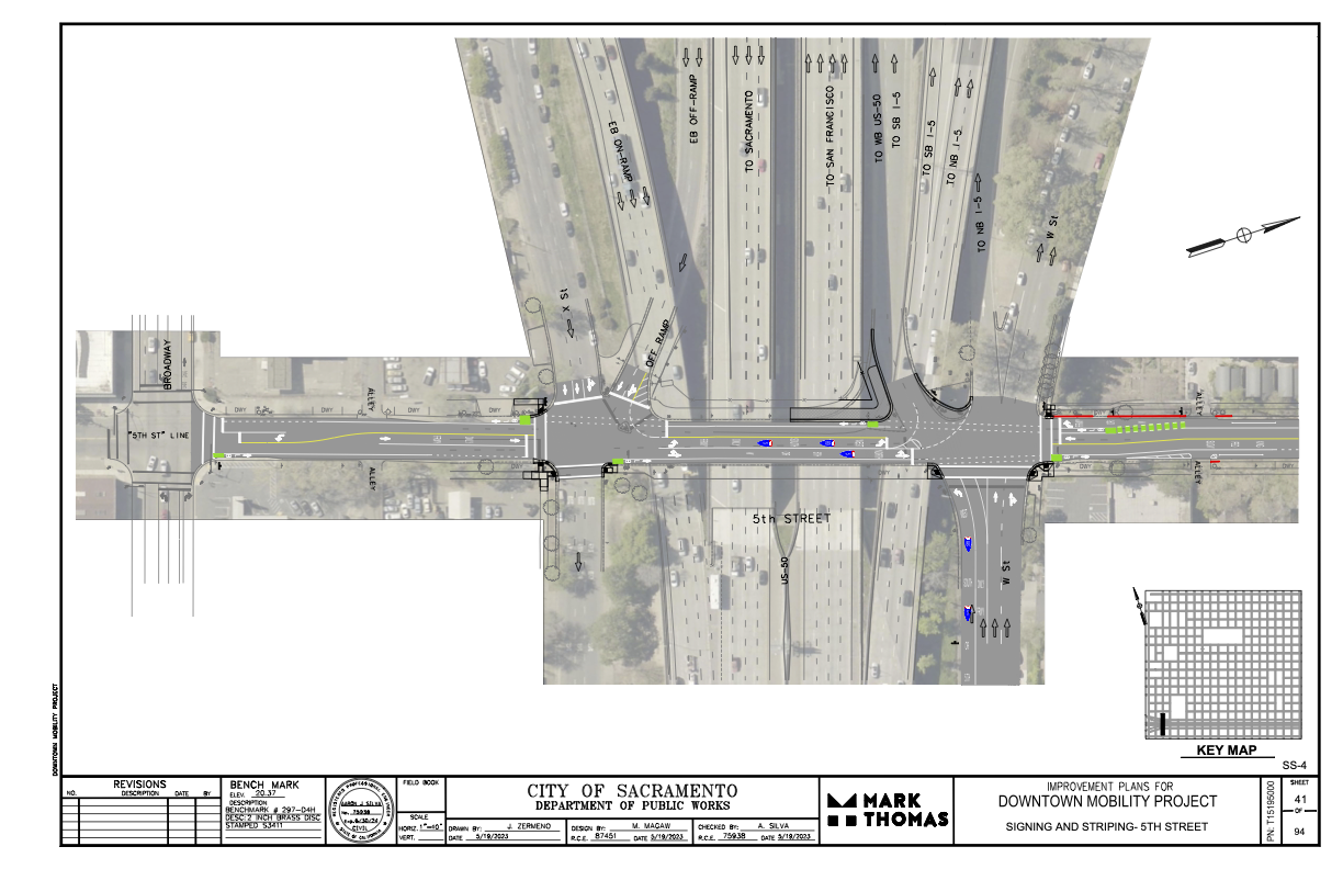
I had earlier expressed concern and lack of information about where the 5th Street one-way to two-way conversion will be handled where 5th Street passes under Hwy 50. (Yes, I know, that this is technically not Hwy 50, but everyone thinks it is, so…)
The following diagram was provided the the city and design firm (pdf). The configuration looks workable, and it probably not any less safe than the current mess. The merging of the two on-ramps into one narrower entrance will probably help to slow traffic entering the freeway, making 5th Street a bit safer. Same with the narrowing of the off-ramp. The curb line will need to be moved in a few locations to accommodate the entire street width with bike lanes, but the curbs here are already quite deteriorated, so that work would be needed in any case. It is not clear from the diagram whether the missing sidewalks in the block between Broadway and X Street will be corrected.
Note: Info on 9th Street and 10th Street added below.
For other posts on the City of Sacramento Central City Mobility Projects, see category: Central City Mobility Project. I’m not sure how interested readers are in my minor updates, but I think it is fascinating to see how the city is repurposing street right-of-way, solving problems (or not), and what is being prioritized in the overall project. I’ve not seen any signs of construction on P and Q streets, other than the ADA ramp work that has been going on for several weeks.
Turn Wedge
The project page has a diagram that I had not exactly seen anywhere before, the corner wedge, below.
Central City Mobility Project diagram turn wedge
I saw a location marked for a turn wedge yesterday, at 21st St and O Street, southwest corner, below. This is a little bit like a corner of a protected intersection.
Sac_21st-St-O-St-SW_turn-wedge
5th Street Two-Way Conversion
I looked at the length of 5th Street, from Broadway to I Street. I still have no insight into what will be done under Hwy 50 where there is a one-way block that is closely tied to the freeway onramps. I have requested clarification from the city but they have not answered yet. I’ll update when I hear.
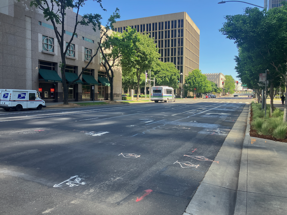
Signal bases have been installed for new signals from W Street to N Street, but not north of there. Active work was going on at N Street. At R Street, it looks like the existing pedestrian flashing light will be duplicated for the other direction. This is not a full signal, nor a user-activated signal, but always on.
Between Broadway and X Street, 5th Street is two-way, four lanes, with sharrows marked (and very faded) in the outside lane. Sharrows are no longer considered valid bikeway markings, so presumably there will be marked bike lanes here. There are three very-wide blocks for 5th Street, from N Street to L Street, and from J Street to I Street. From N to L, there are two through lanes and one or two left-turn lanes, plus parking and bike lanes. From J to I, there are two through lanes and two left-turn lanes, plus parking left and right and a bike lane on the right.
On the west side of the intersection of 5th Street and I Street, there is a crossing prohibition. I hope that the city removes this prohibition as part of the project. In most cases, freeways onramps and off-ramps being an exception, crossing prohibitions are an attempt by the transportation agency to prioritize motor vehicle volume and speed over all other considerations. They are morally wrong, and should be legally wrong.
Sac_5th-St-N-St_extra-wide
I Street Separated Bikeway (and lane reduction)
Some work has started on the I Street separated bikeway, which will run from 21st Street to 12th Street (see the importance of I Street for why it should continue west). Most corner ramps were already ADA compliant, but the few that were not have either been upgraded or are in progress. Fabric covers have been set up over drain inlets, and temporary no parking signs line the street, so I assume repaving will occur soon. I don’t see any indication of whether the separated bikeway will be on the right side or left side of the street. I Street does not have SacRT fixed route bus service, which engenders left side bikeways, though there is some commuter bus service on the street.
The project map indicates that I Street will be “lane reduction and separated bikeway”, not parking protected separated bikeway, so this will be a different configuration than 19th Street and 21st Street.
I will be interested to see if the city will address the lack of sidewalk on the south side of I Street between 16th and 15th, where the city installed a loading dock for Memorial Auditorium in place of the former sidewalk. I strongly believe that removal of sidewalks, as was done here, are criminal (Sac permanently closes sidewalk).
19th Street Repaving
It looks at though 19th Street is not going to be completely repaved in the way 21st Street was, rather, it is getting spot repaving. I don’t know whether there will be an overlay so that the new marking are on a fresh blank canvas.
9th & 10th Street Parking Protected Separated Bikeway
The 10th street parking protected separated bikeway will be extended from Broadway to Q Street. The block of Q Street to P Street has a buffered bike lane, outboard of parking in the south half, and without parking in the north half, and since that block has recently been changed, it will likely stay that way. There is a buffered bike lane from Q Street to L Street, and then a parking protected separated bikeway of variable quality from L Street to I Street. There is no bus service on 10th Street, so the right side configuration will probably be maintained throughout.
10th Street is relatively wide under Hwy 50, so no special treatment here will be needed.
On 10th Street there are ADA ramp upgrades at several locations, and several more haven’t started yet. The street has a lower rate of ADA compliance than many central city streets. There is no indication of roadwork yet.
The 9th Street parking protected separated bikeway is being extended south from L Street to Q Street. There is no indication of any sort of work here yet. Most corners already have compliant ADA ramps. There is construction on the east side of 9th (right side southbound) between L Street and Capitol Mall, and on the west side (right side southbound) between N Street and O Street, and between P Street and Q Street. All of these construction projects will probably be going on for quite some time, and this may be the last street to be modified. SacRT Bus Route 51 runs on 9th Street south of Q Street to Broadway, which is outside this project scope, but presumably argues for keeping the left side bikeway configuration throughout.
The SACOG Regional Bike Share Policy Steering Committee met this week on Monday (agenda). This was the first meeting of the committee in quite some while, long enough that the staff member did not remember when the last one was. The committee is almost entirely new people since the last meeting. Members are: Alberto Ayala (Sac Metro Air Quality District), James Corless (SACOG), Dawnté Early (City of West Sacramento), Caity Maple (City of Sacramento council member D5), Katie Valenzuela (City of Sacramento council member D4), and Chair Josh Chapman (City of Davis).
There was a presentation by SACOG staff Nicole Zhi Ling Porter on the status of bike share/scooter share (or micromobility) in the region, as well as questions that the policy committee will help answer. The main question is the ownership and operations model, with three options”
privately owned and operated (the current model)
publicly owned and operated
publicly owned and privately operated (under contract)
These are not exclusive categories. Several existing bike share programs have detail models for operations, using some sort of public/private partnership.
The City of Davis and UC Davis are undertaking a study to determine the model they want to use and the operators. They did not rejoin the regional program after the pandemic shutdown. It has apparently not been decided that they will not rejoin the program, but they wanted to consider other options. There may be an announcement about this in the near future.
The current bike share fleet is about one-third the number of bikes that were available before the pandemic, which was about 900. Sacramento was in fact the most successful bike share system in the country, as measured by number of rides per bike per day. The system is now an also-ran.
Several committee members mentioned that rental costs were now much higher, and that was probably depressing use. I have to admit that I am a Lime Access member, meaning that I don’t pay for individual rides of up to 30 minutes, so I have not noticed the per-minute fees.
I was the only public person in attendance in the room. One person spoke on Zoom, but I have not way of knowing if there were more people observing on Zoom. Note that I am a user of the bike share, not of the scooter share, and don’t have much perspective on scooters, I expressed these concerns, which I hope committee will address:
Instability: The unannounced shutdown of the system at the beginning of the pandemic was not the desire of the public, which wanted to continue using the bikes. This type of issue, determined solely on the whims of the operator/owner, is not acceptable to the users, and any new policy must address this issue.
Maintenance: The bikes are not being maintained to an acceptable level of good repair. About 1/4 of the bikes I try to rent are unrideable for various reasons, about 1/4 are rideable but have significant issues, and about 1/2 are more of less OK.
Distribution: The agreement between the operator/owner requires that some bikes be distributed/rebalanced into low income neighborhoods within the service area (many are not in the service area, but some are). My observation, both from being on the streets and checking the app, indicate that this is not being done.
Transit integration: The JUMP bike share system was for a time somewhat integrated with transit. Bike charging stations were located at a number of light rail stations. But when Uber took over the system, these charging stations were removed. So there is no integration at this time. Bike share and transit can complement each other in critical ways, but the current system is operating without that insight. There are a few systems in the country where the transportation/transit agency also operates the bike share system, Los Angeles Metro for example. Though this system is not perfect, the integration is noticeable, and the rental rates are significantly below that of private systems.
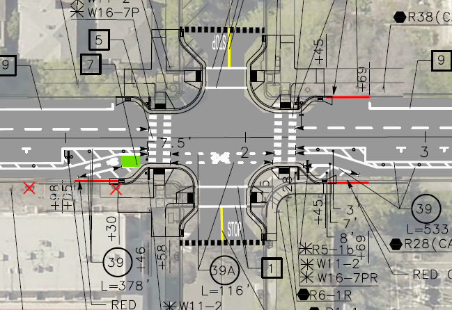
More information on the curb extensions (bulb outs) being installed on the northeast and southeast corners of the intersection of 19th Street and O Street, as part of the Central City Mobility Project. I questioned this location for curb extensions because 19th Street with have a parking protected separated bikeways on the left side (southbound) of 19th Street. (Central City Mobility update)
I received a response from the engineering firm for the project:
This is in response to your inquiry as to compatibility of the subject intersection revisions and parking protected bike lane. The design does account for the bulb outs at the intersection. Unfortunately, due to the space restrictions resulting from the bulb outs, it won’t be possible to provide parking protected all the way around the bulb outs. However, we are providing a transition of the bike lane at the intersection. Please take a look at the following striping design for the intersection. North is to the right with 19th Street running left to right. Hopefully this will give you a better feel for the plan:
Any reader of this blog will know that I love curb extensions. What confuses me is why this location would have been selected by the city over many other potential locations. Perhaps some of the reason it that the crossing at O Street has a moderately high walker count, but does not otherwise have a traffic signal or pedestrian signaling such as a RRFB. It is possible that the city thought these four corner curb extensions to be the most practical way of increasing safety for walkers and bicyclists crossing at this point.
The design of bringing the separated bikeway out adjacent to the general purpose travel lane, as a bike lane, is not ideal but not particularly unsafe. In fact some bicyclists prefer this design, because it increases the visibility of bicyclists by motor vehicle drivers, so that they are not ‘hidden’ behind parked cars. Though daylighting of the intersection approach can accomplish the same objective.
I would like to see green skip paint continuing through the intersection in the bike lane. These are often painted as discontinuous green rectangles with sharrows stenciled on top, called green-backed sharrows. The sharrows are out of favor with most bicyclists and some traffic engineers, I think this is a valid use of them. The main purpose of green paint (it has no legal meaning) is to increase driver awareness of bicycle facilities by highlighting conflict points, and this is definitely a conflict point.