At the other end of the bike lane

bike-lane-symbol-farI have long wondered why so many people ride the wrong way in bike lanes. The common label for these bicyclists is “salmon,” probably from Portland, signifying they are swimming upstream against the current. Good for spawning salmon (and bears), bad for bicyclists. There are some evident reasons for wrong-way riding:

  1. The completely wrong but common misunderstanding that bicyclists should ride facing traffic. The origin of this is the “walk facing traffic if there is no sidewalk” rule. It doesn’t apply to bikes, but when teaching bicyclist education to youth, I often hear them mention this as something their parents have taught them. In fact, riding the wrong way is the most common bicyclist-caused source of crashes, though these are usually injury crashes and not fatal crashes.
  2. One way streets make it difficult to get where you are going, so many people ride the wrong way to get where they are going. Understandable, but wrong.

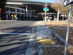
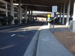
I’ve recently come to realize, however, that the common bike lane design fails to discourage wrong-way riding by not marking the end of the bike lane with a direction. The beginning, departing an intersection, is marked with the bicycle symbol and arrow, but the end, approaching an intersection is not. So a person entering the bike lane does not immediately realize they are going the wrong way. Once they do realize it, I think they often just continue along their way rather than changing course to ride with traffic.

The solution? Mark bike lanes at both the beginning and end. That way a person going the wrong way immediately sees that they are going the wrong way.

What is the downside? There may be some confusion induced between the dashed line message, which is that this is a merge area for the regular lane and the bike lane, and the bike lane symbol, which seems to indicate that the exclusive bike lane continues. I don’t see this as a stopper, but it is an issue to be addressed. It is possible that a different variation of the pavement marking could be used, but another symbol is probably not what is needed.

North 12th Street Complete Street Project

North12thSt-logoThe City of Sacramento is soliciting input on the North 12th Street Complete Street Project, the most significant portion of which would install a two-way cycletrack on the west side of 12th Street between the Hwy 160 bridge over the American River near Richards Blvd, and as far south as F Street.

The project should be compatible with and benefit from the Choice Neighborhoods Initiative Twin Rivers project which would revitalize the Twin Rivers Community Housing and the surrounding area. The January 2014 Final Transformation Plan is available from SHRA.  Though the plan does not go into great detail on streets and transportation, page 78 does provide a good overview of the changes and the relationship to 12th Street and other efforts in the River District and Railyards. In particular:

  • Richards Blvd would be realigned and extended east of 12th St
  • several streets intersecting 12th St would be reconfigured, particularly Bannon St
  • a potential SacRT light rail station near the redevelopment and Richards Blvd

There is also a City of Sacramento project to add sidewalks to the east side of 12th St between B St and Richards Blvd.

Read More »

Best Foot Forward Summit – join me?

California Walks, the statewide advocacy group, is hosted the Best Foot Forward Summit in Oakland on November 8th & 9th. I’m thinking of attending, but am unsure how exactly to make use of the summit to support efforts in the Sacramento region. If a critical mass of people from Sacramento attended, then we could have very useful discussions at the summit, and come to a consensus about how we can use the experience to move things forward here. However, there are only four people from the region registered at the moment. On the other hand, those who do attend could bring back a summary and skills for working on our regional issues, and share them locally with others. At the moment, it does not appear that WALKSacramento has the capacity to implement either of these ideas. But I’m asking that every reader here will consider the opportunity, and then share what they think, either by commenting here on the blog or by responding to the @GetAroundSac tweet and using the hash tag #BestFootForwardSummit.

What we know is that the transportation agencies in the region will move at a snail’s pace to improve walkability and livability, unless we exert strong public pressure on them. In fact, I believe that the harm they do will continue to outweigh the good they do, for some while, as they cling to outmoded ways of thinking and outmoded views of the kind of place that resident want. It will take a transformative experience to get advocates fired up and moving forward, together. I’m not sure if this is that experience, but I’d like to know what you think.

I am not minimizing the work of WALKSacramento and other advocates that have made a difference, particularly in the lower income South Sacramento area. This is all good work, and the priorities identified by community participants reflect the changing needs and desires of the region, but it is a drop in the bucket of what needs to take place.

Walk to School Day?

Today was Walk to School Day. If any schools in the region have photos or stories to share, I’d be glad to post them, or link to other sources. I think your photos and stories will be an inspiration to others, and fuel for the next major event, Bike to School Day next May. I hope that you had a successful celebration!

Who rides e-bikes?

I have noticed, as I ride around the Sacramento region, that about 90% of the e-bikes are being ridden by young, apparently healthy males. Of course it is true that not all disabilities are apparent, and that some of these e-bikes may be the perfect solution a person with a disability. However, I wonder at the user profile. Why are young, healthy males riding e-bikes when they could be riding regular bikes? And why am I not seeing more elderly, and more visibly disabled, people riding them? It seems strange to me. Just saying…

Walk to the grocery store

Strong Towns issued a challenge to document your walk to the grocery store. Here is my contribution.

N Street, nice crosswalk, rude drivers

Grocery Outlet: One-and-a-half blocks. Out the apartment complex gate, through the alley, along and then across a quiet residential street (17th), across a two-lane one-way traffic sewer (N), and a block to the store. There are good sidewalks the entire way. Both crosswalks are clearly marked. The traffic on the larger street rarely yields to pedestrians, though that is the law in California, but most of the time it is not a long wait for a gap. I visit this store 2-3 times per week, almost always walking and carrying one large bag

Safeway: Nine blocks, 0.5 miles. Good sidewalks, nice streets, two semi-traffic sewer one-way streets (P, Q, same story, drivers seldom yield but gaps are available), one block without sidewalks but on a low traffic street (R). Sometimes I walk, sometimes I ride.

Sacramento Natural Foods Coop: 1.4 miles. Good sidewalks, mostly nice streets, several one-way traffic sewers (P,Q, 19th, 22nd, 29th, 30th). I occasionally walk this, but most often ride. I could take light rail, with a two block walk on both ends, but I seldom do. Depending on route, I can have quiet streets and/or bike lanes most of the way.

Trader Joes: 2.5 miles. Good sidewalks, mostly nice streets, two more traffic sewers than above. I have walked this, but rarely. I can take light rail, and sometimes do, two blocks walking on one end and three blocks on the other end. Mostly, I ride. Quiet streets part of the way (M Street, the closest we have to a bicycle boulevard), bike lanes available but on the less pleasant streets.

Farmers markets: Saturday farmers market seven blocks, 0.6 miles; Sunday (main) farmers market, 1.3 miles; other farmers markets at varying distances

You might think, well how lucky to live close to a store, but luck has nothing to do with it. I chose this place to live primarily for its proximity to grocery stores. Other considerations were tree lined streets, close-by coffee shops, restaurants, bars, bike shops, breweries, etc. Walk score is 86, and yes, I did look at it before I moved here.

I have a bag on my bike that is perfect for carrying groceries, and I can carry quite a bit of weight that way. I am also willing to carry quite a bit of groceries when walking. I prefer to go to the store more frequently so that I can have more fresh food. No family, I’m just shopping for myself.

More photos: Transportation (collection) > Sacramento sidewalks (album) > Walk to the Grocery Store (tag)

Bike Corral on L Street

bike corral, L Street, between 19th and 19th

There is a new bike corral in Sacramento, on the north side of L Street between 19th and 18th, in front of Ginger Elizabeth Chocolates. This is one of the two bike corral locations set in the city’s bike corral program (linked below) Phase II effort, with the other being some racks in a large area set aside to calm traffic at the intersection of N Street and Folsom Blvd. Phase I includes the two corrals at Insight Coffee on 8th Street, and Pangaea Two Brews on Franklin Blvd.

This corral, and the two Phase I corrals use the Park-a-Bike Varsity rack, which is becoming somewhat of a standard in the Sacramento region. The N Street corral uses more traditional but effective U-racks.

Please stop by these locations and visit the businesses which have requested the corrals!

Six more locations were tentatively identified but have not been officially selected yet.

More photos on Flickr: https://www.flickr.com/photos/allisondan/sets/72157645000793015/

Approve Bike Corral Program Guidelines and Initial Installation (City of Sacramento 2014-02-25)

Car free gains?

I read with interest the Streetsblog DC post “The American Cities With the Most Growth in Car-Free Households” and wondered about Sacramento. I dove into the American Community Survey, using the same 2012 ACS 1-year and 2007 ACS 1-year data that the research had used to look at the number of car-free households in other cities. Over the period when the national average increased from 8.7 percent share of households without a vehicle to 9.2, the six-county Sacramento region increased from 5.7 to 6.8. Not very impressive, but the change or delta was an impressive 18.8%. Yolo County, probably Davis, led this change with a remarkable 76.2% increase!

Below is the chart of change from 2007 to 2012, for the City of Sacramento, El Dorado, Placer, Sacramento, Sutter, Yolo and Yuba counties, and the region, which is an average of those six counties. Following the chart are the numbers I retrieved from ACS. If you would like to look for yourself, go to the ACS Advanced Search, and then under Topics select Housing > Occupancy Characteristics > Vehicles Available.

In the blog post, the largest major city increase was Detroit at 5%, and our neighbor San Francisco was sixth at 1.9%.

I’m not quite sure what to make of these numbers. Is there a flaw in my logic? I had to impute the no vehicle households from the total households and percentages for 2007, because the actual number doesn’t seem to be available in the data tables. Were the numbers so small in 2007 that such large changes don’t really mean much? I don’t know. Your thoughts?

change in no vehicles, 2007 to 2012

ACS data
ACS data

I Street into Old Sacramento

The City of Sacramento sponsored Envision Sacramento website seeks input from the public on a number of issues. One of the topics was “What are your ideas on improving the Old Sacramento connection from downtown Sacramento via I Street?” You can view the comments, just below the survey, but to comment yourself you must create an account.

I Street entrance to Old Sacramento, from Envision Sacramento

The topic uses the photo at right to illustrate the question. What you can’t see in the photo is that behind the photographer and across 3rd Street (to the left), pedestrian access is on the south side, but to the west, it is on the north side.

Comments include a number about the aesthetics of this entrance to Old Sacramento, including the having a dark freeway under crossing as the main route into the one of the highlights of Sacramento, with poor signing for motor vehicle drivers, bicyclists, and pedestrians. A surprising (to me) number of comments, though, were about the transportation aspects, that it is really not safe for bicyclists or pedestrians to use this entrance, even if they know it is there, and the paucity of other options. I think it is clear that the commenters agreed that the way in which Interstate 5 severed the connections between downtown and Old Sacramento is a major issue.

A gallery of photos shows some of the specific problems at this location.

Read More »

Gallery: I Street into Old Sacramento

These photos are of the I Street entrance to Old Sacramento, showing various problems and hazards that exist for pedestrians and bicyclists at this location. The crosswalks here are not really safe. All sorts of signing has been installed to try to make them safe, but that is a poor substitute for correct design. The […]