SacATC March 21

Update: Diagrams were added for agenda item 3 streetcar-related bikeway on 3rd Street and agenda item 5 T Street bikeway improvements with unneeded parking.
Update 2: Information added about Envision Broadway in Oak Park, one of the project applications desired for ATP7.

The monthly meeting of the Sacramento Active Transportation Commission (SacATC) will be this Thursday, March 21, 2024, starting at 5:30 PM in the city council chambers. You can comment on these items, or on topics not on the agenda, ahead of time via eComment, or in person at the meeting. I encourage people to attend these commission meetings. There are usually very few members of the public in attendance, which means that your voice is important. Though eComments are valuable, in-person comments carry a lot more weight. The city’s planning staff is usually progressive and innovative, but Public Works in general is not, so it is important the citizens show up to push for progressive and innovative projects and policies. With some new appointments to the commission, and support of the public, the commission itself has been much more progressive than in past years.


The agenda includes four discussion items:

  1. Downtown Riverfront Streetcar Project – Active Transportation Elements
  2. Draft Parks Plan 2040 Public Release
  3. T Street Bikeway Gap Closure Rehabilitation Project (R15200030)
  4. Active Transportation Program Cycle 7 Grant Applications 

Item 6 is mislabeled as a discussion item since it says: “Pass a Motion to recommend to City Council the approval of applications to the Active Transportation Program Cycle 7 grant applications for the following projects: a) Envision Broadway in Oak Park; b) Freeport Boulevard Safety and Mobility Project; and c) Northgate Boulevard Safety and Mobility Project.”

The Downtown Riverfront Streetcar Project, for a streetcar or light rail extension from Sacramento Valley Station to Sutter Health Park in West Sacramento, with an alignment over Tower Bridge, south on 3rd Street, east on N Street to 7th Street (southbound) and 8th Street (northbound), and along existing tracks to Sacramento Valley Station. Class IV bikeway is proposed on 3rd Street southbound, off or left side, and N Street eastbound, off or left side. There is no detail about what kind of Class IV bikeway, which can be: ““A bikeway for the exclusive use of bicycles and includes a separation required between the separated bikeway and the through vehicular traffic. The separation may include, but is not limited to, grade separation, flexible posts, inflexible posts, inflexible barriers, or on-street parking.” Since the bikeway is not parking protected, a high level of protection and separation is appropriate. Both the map and StreetMix diagram are too fuzzy to determine bikeway and buffer width, but it appears the bikeway buffer is narrow and without vertical delineators. The three general purpose lanes are 11 feet, unnecessarily wide and unsafe, so there is additional space that could be allocated to the bikeway or buffer.

StreetMix diagram of 3rd St, excerpted from agenda item

The Parks Plan 2040 (to align with the General Plan 2040) includes many mentions of trails, particularly in the context of Parkways: “Parkways: There are 14 parkways across the city. All parkways contain multi-use trails; some have artwork, gardens, river/beach access, and picnic areas. A select few offer sports recreation facilities such as basketball, soccer, and volleyball.” Key Direction 6, Foster Nature and Trail Connections includes “Collaborate to Improve Trail Connections: As noted in Appendix D, YPCE will continue to coordinate and collaborate with Public Works, other City departments, Sacramento County, and other agency partners to improve trail connections to parks, parkway use, and recreation via trails. While YPCE is not the primary provider of the City’s shared use paths, the Department brings an important perspective to conversations regarding priorities for shared use paths that support recreation and park access in addition to active transportation. Going forward, YPCE will proceed with the development of planned future parkways, especially where these provide access to rivers, connect missing trail links, and provide access to new parks and neighborhoods.” The Community Voices section (04) indicates strong community support for trails.

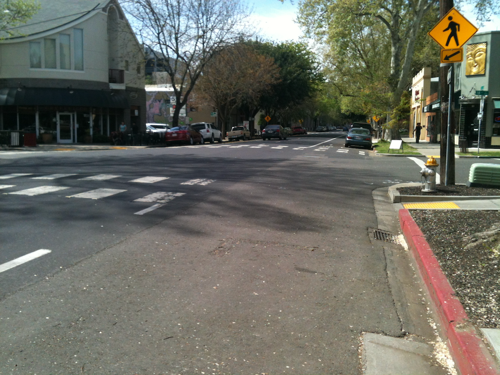
The T Street bikeway improvement project is needed, from 34th Street to Stockton Blvd. I bicycle this section regularly, on my way to Trader Joe’s and other destinations. The bike lane comes and goes, and drivers often refuse to yield to bicycles taking the lane, trying to force them to the side, and then right-hooking them at Stockton Blvd. The included diagrams seem to indicate there will be parking along the north side of T Street between 35th Street and 34th Street, which is completely unnecessary since the north side is entirely a Caltrans corporation yard with no need for parking. About two-thirds of the south side is also Caltrans property under the freeway, again with no need for parking. T Street is reduced from four travel lanes to two travel lanes from 34th Street to 36th Street, which is a great traffic calming improvement over the overly wide street that exists (or did, before the Hwy 50 construction narrowed it). The right hand lane approaching Stockton Blvd should be right turn only, so that T Street drops to one lane east of Stockton, without the need for a merge which endangers bicyclists. My observation is that at least half the eastbound traffic on T Street turns right onto Stockton, rather than continuing straight onto T Street or turning left onto Stockton. There are also bike lane improvements on the section of 34th Street approaching T Street.

Google map of T St between 34th and 35th streets, showing unneeded parking
T St between 34th and 35th streets, showing unneeded parking

The city is proposing to submit three applications to the Active Transportation Program Cycle 7: a) Envision Broadway in Oak Park; b) Freeport Boulevard Safety and Mobility Project; and c) Northgate Boulevard Safety and Mobility Project.

I have not looked in any detail at the Envision Broadway in Oak Park project, which lies to the east of the current Broadway Complete Streets project. If the same street cross-section and neglect of sidewalks is continued east, it will be a bad project, but perhaps this is an opportunity to correct the design mistakes built into Broadway Complete Streets.

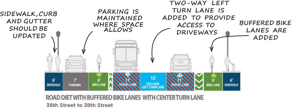
Added information on Envision Broadway. Overall, the plan looks good. Of concern is the section from 36th Street to 38th Street, where the right-of-way is narrower, and existing sidewalks are mostly 5 feet, which is unacceptably narrow for this corridor. The plan says “South of 36th St the rolled curb and gutter and attached sidewalks should be replaced with vertical curbs and wider sidewalks where feasible”. The phrase ‘where feasible’ is concerning. Would we say that general purpose lanes would be installed ‘where feasible’? Of course not. Sidewalks must be a minimum of 6 feet throughout this section, even if other modes are reduced. The sidewalks will not have sidewalk buffers for planting trees, so this section will be unshaded, except for a very short area between 36th Street and 4th Street, where there is a buffer, and a few trees on private property.

The project should still be recommended by SacATC, but with recognition that the plan falls short in facilities for walkers.

The initial Freeport Blvd Transportation Plan was deeply flawed, but perhaps this preliminary engineering and environmental clearance phase can correct some of those flaws. If not, then Freeport will stand as an example of how the city still prioritizes motor vehicles over all other users, and over trees. If the the city does not make a commitment to significantly improving the plan during this phase, then I believe the community should oppose this grant application, at SacATC, and California Transportation Commission, and at SACOG.

Previous posts on Freeport Blvd: Freeport Blvd to council today, Freeport ideas from Kevin, Freeport Blvd as a failure of vision and possibility, Freeport roundabout(s), Freeport trees and sidewalk buffers, Where are the trees on Freeport?, Freeport Blvd photo essay, Freeport & Fruitridge intersection, make Freeport 3 segments, wide lanes on Freeport, Freeport Blvd Transportation Plan, Freeport Boulevard Transportation Plan Emerging Design Concepts. These posts are included under the category Freeport Blvd.

The Northgate Blvd Mobility Plan was much better, with just a few areas of improvement, so this application should be supported.

crosswalk daylighting in SacCity?

AB 413 (2023, Lee), the Daylighting Saves Lives bill, became law last year. It prohibits stopping, standing or parking a vehicle within 20 feet of any crosswalk, whether marked or unmarked. CalBike: Intersection Daylighting Becomes California Law. The law also details that it applies to the approach side (upstream), and is 15 feet if a curb extension is present. Until January 2025, only warnings can be issued. Either red paint or a sign is required. It does allow a ‘local authority’ (city or county) to establish a different distance with justification and by painting or signing a different distance. Another exception is for commercial vehicle loading and unloading, where the specific crosswalks are identified in ordinance and they are marked by paint or signing. Bicycle and scooter parking can be placed within the 20 feet, which is great since much of the city lacks sufficient parking for these devices.

photo of red curb offset for daylighting, L St at 18th St
red curb offset for daylighting, L St at 18th St

I fully support this law, though I would have modified it in some ways. I don’t think the 15 foot distance where a curb extension is present is necessary. The daylighting here can be ‘enforced’ by design. I would have made an exception for passenger loading and unloading (white curb), not for commercial vehicle loading and unloading (yellow curb). Commercial vehicles usually don’t stay long, but they are almost always large and effectively block visibility, whereas private vehicles are usually smaller and block visibility to a lesser degree. Of course we need commercial loading and unloading zones, many more than exist, so that bike lanes and travel lanes are not blocked, but approaching crosswalks is not the right place. Most drivers don’t understand what curb colors mean anyway, but that is a matter for education, not for not using them. Green, by the way, signifies limited time parking, which is posted on signs or stenciled on green curbs.

So, how will the City of Sacramento respond to this? The city has over 700 signalized intersections. It is unknown how many total intersections there are, but it is likely in excess of 15,000, and for most intersections there are four crosswalks, so in excess of 60,000 crosswalk approaches. There isn’t and likely won’t ever be funds to mark or sign all these. So how should the city select locations? One criteria that should not be used is how much demand there is for parking on a particular street. This is about safety, not parking. So possible criteria, similar to that presented for ‘no turn on red’ (no turn on red for Sacramento?):

  • locations of crashes: This is a no-brainer. Red curbs or signs should be installed at any intersection where there is a history of crashes involved walkers and bicyclists. This should be city policy, to install signs at any location where SWITRS indicates there is an issue, or immediately after any crash.
  • crosswalks with a high walker count: This is probably the most beneficial for safety. The problem is that the city does not collect data on the number of walkers using crosswalks (marked or unmarked), so it would not know where to start. The lack of data collection is a failure on the part of the city, but it is nevertheless a fact.

There are other possible criteria. The city’s Vision Zero Action Plan (2018) identified ‘Parking Restrictions Near Intersections’ as a countermeasure specifically for drivers making left or right turns impacting walkers and bicyclists, with a high efficacy, low cost and low complexity. The Top Five Corridor Study identified Marysville, El Camino, Broadway/Stockton, South Stockton and Florin segments as dangerous roadways for safety improvements. Unfortunately the Vision Zero effort was limited to corridors, and not high injury intersections. It should have also identified the top five, or ten, intersections. Nevertheless, the city does have data on these intersections that could be used to identify high priority fixes.

The separated bikeways with turn wedges on P Street, Q Street, 9th Street, 10th Street, 19th Street, 21st Street, and I Street largely address the issue without needing additional marking or signing, on the side on which the bikeway is installed, but the other side would still need marking or signing. The separated bikeway on J Street has daylighting at some but not all crosswalks.

The highest safety benefit accrues to curb extensions, temporary at first and permanent in the long run. Temporary extensions are inexpensive and can be installed quickly (Strong SacTown quick-build street safety), while permanent extensions are more expensive and require planning. Sometimes curb extensions require relocation of drain inlets, which increases their cost.

no turn on red for Sacramento?

Update: I was incorrect that a ban citywide would not require signing. See below for more information. Thank you, Matt, for the heads up.

Many places throughout the United States are considering banning turns on red signals. Permitting turns on red was a fuel-saving practice implemented in the 1970s, though there is little evidence it actually saved fuel. There is considerable evidence that it decreases safety for walkers and bicyclists, and perhaps motor vehicle drivers and passengers. Though turns on red signals are not the greatest danger walkers and bicyclists face, banning the practice would have safety benefits. It is a partial protection against oversized SUVs and trucks, which have large blind zones that contribute to striking walkers and bicyclists. Though people think of this as no-right-turn-on-red, in Sacramento central city with its overabundance of one-way streets, it may also be no-left-turn-on red.

San Francisco is considering an expansion of its no-turn-on red zones from the Tenderloin, where it has increased safety and calming traffic, to more of the downtown area. Washington DC has banned turn-on-red, though it doesn’t take effect until next year. Chicago and Seattle have considered bans.

The signs used to indicate no turn on red are:

How should the City of Sacramento, and the rest of the counties and cities in the region respond? The options are:

  • ban citywide: Turns on red would be illegal throughout the city (or county). The advantage is that no signing would be needed since it would apply to all signalized intersections. However, this may not have as great a safety benefit as a more targeted approach.
  • ban at locations of crashes involving turning vehicles: This is a no-brainer. Turn on red should be banned at any intersection where there is a history of crashes caused by vehicles turning on red. This should be city policy, to install signs at any location where SWITRS indicates there is an issue, or immediately after any crash.
  • ban at intersections with a high walker count: This is probably the most beneficial for safety. The problem is that the city does not collect data on the number of walkers using crosswalks (marked or unmarked), so it would not know where to start. The lack of data collection is a failure on the part of the city, but it is nevertheless a fact.
  • ban at separated bikeway locations: A ban at the intersections with separated bikeways (also called protected bike lanes, parking-protected bikeways, or cycletracks) would protect bicyclists and give them a head start over motor vehicles. Leading pedestrian intervals (LPIs), which bicyclists can also use, can offer even better protection.

I have resisted turn-on-red bans in the past because I thought they had a lower safety benefit than many other measures that could be taken, but traffic violence has become such an issue that any action to reduce death and injury for walkers and bicyclists may be worth taking, and taking now.

As an alternative to bans, yield-to-pedestrians (and bicyclists) signs can also be installed. Two versions are shown below, on the left, the approved MUTCD R10-15R sign, and on the right, the bicyclist and pedestrian version with interim approval in California, and in use in many locations. My observation is that these signs are widely ignored by drivers, but of course, they do help those drivers who are willing to follow the law.


California Vehicle Code (CVC) 21453

CVC 21453: 
(a) A driver facing a steady circular red signal alone shall stop at a marked limit line, but if none, before entering the crosswalk on the near side of the intersection or, if none, then before entering the intersection, and shall remain stopped until an indication to proceed is shown, except as provided in subdivision (b).
(b) Except when a sign is in place prohibiting a turn, a driver, after stopping as required by subdivision (a), facing a steady circular red signal, may turn right, or turn left from a one-way street onto a one-way street. A driver making that turn shall yield the right-of-way to pedestrians lawfully within an adjacent crosswalk and to any vehicle that has approached or is approaching so closely as to constitute an immediate hazard to the driver, and shall continue to yield the right-of-way to that vehicle until the driver can proceed with reasonable safety.
(c) A driver facing a steady red arrow signal shall not enter the intersection to make the movement indicated by the arrow and, unless entering the intersection to make a movement permitted by another signal, shall stop at a clearly marked limit line, but if none, before entering the crosswalk on the near side of the intersection, or if none, then before entering the intersection, and shall remain stopped until an indication permitting movement is shown.

https://leginfo.legislature.ca.gov/faces/codes_displaySection.xhtml?lawCode=VEH&sectionNum=21453.

Under section (b), signs are required, even if the ban is citywide. Section (c) does allow use of red arrows, but the red arrow signal would be more expensive than a sign, so only used in a few situations. The blank-out sign, shown above in the set of three, is probably the most effective, but again, more expensive that a regular sign.

Strong SacTown quick-build street safety

Strong SacTown has created a great visual introduction to quick-build fixes for street safety, posted to Instagram. I encourage you to take a look. The series includes curb extensions and modal filters (traffic diverters), both quick build with temporary materials, and permanent installations. Of course temporary materials should eventually be replaced with permanence, but it is better to get something on the ground now rather than waiting for the planning and money it takes for permanent installations. We are experiencing an epidemic of traffic violence, and even small actions can reduce fatalities and injuries. These installations are also called tactical urbanism, though the definition of quick-build and tactical urbanism is not identical.

Some additional ideas that are not always thought of as traffic calming.

Street Design

We can design better streets to begin with so that the need for traffic calming is reduced. Example one is the wide medians in Boulevard Park, which reduces turning movements to the intersections while providing a pleasant environment. Example two is wide sidewalk buffers in the Poverty Ridge area, where narrow streets reduce vehicle speeds, and the sidewalk buffers provide a pleasant environment. I have watched motor vehicle drivers passing each other on these narrow streets in the Poverty Ridge area. They are slowing to about 5 mph to pass. This is a traffic violence reduction design in action!

wide street median, 22nd St at C St in Boulevard Park
photo of narrow street with wide sidewalk buffers, V St at 21st St
narrow street with wide sidewalk buffers, V St at 21st St in Poverty Ridge
Read More »

the end of red light enforcement

A SacBee article today notes the end of the red light camera program in City of Sacramento, which was part of Sacramento County’s program: Sacramento’s red light camera program has been shut down by the Sheriff’s Office. Here’s why. (sorry about the firewall)

This is very sad news, given the epidemic of red light running in the City of Sacramento (and elsewhere). I’ve written about this before: how do we get more red light cameras?, red light running consequences, SacCity red light cameras and crashes, Sac Vision Zero intersections & red light cameras, red-light-running bullies, and pandemic of red light running. It has only gotten worse over time, and will continue to get worse unless the city takes action to reduce it.

A quote from the Sacramento County Sheriff’s Office is particularly galling: “Gandhi said the Sheriff’s Office wants to focus on its mission of suppressing violent crime and other criminal activity.” Apparently, in the view of law enforcement, traffic violence is not a violent crime. Apparently, the fact that red-light runners kill and injure walkers, bicyclists, passengers, and other drivers is of little concern. Sadly, this is a very common law enforcement attitude.

If cost-cutting were an appropriate response to criminal activity, it would be reasonable to just eliminate law enforcement. Law enforcement responds to criminal activity; it does little to nothing to prevent criminal activity. Automated red light enforcement is an effective response to criminal activity, and it does reduce future criminal activity. Why is the Sheriff’s Office and the City of Sacramento not interested?

If you think that direct law enforcement of red light running is a good replacement, you would be wrong, for two reasons. One, almost no enforcement of motor vehicle violations occurs anymore, other than some enforcement of speeding. Two, the law enforcement practice of pretextual stops, stopping people of color for traffic violations to search for other violations, and to intimidate people of color, results in law enforcement violence against drivers of color.

One of the useful things the city was doing to reduce traffic violence is no longer. Don’t you feel safer now? You can visit the city’s Red Light Running Program page, in case you wish to leave condolences, remembrances, or flowers.

photo of red light camera, from City of Sacramento
red light camera, from City of Sacramento

Instagram? maybe…

Update: I have decided that, for now, I’m only going to follow back transportation organizations and agencies. My concern is that if I start following individuals, my feed will become overwhelming for the limited time I have for Instagram.

As an experiment, I have created an Instagram account for Getting Around Sacramento. I started using Instagram for the Week Without Driving Sacramento campaign last year, on the encouragement of one of the program partners, SABA, which has an active Instagram. I maintain the WWD Sac website on behalf of Sacramento Transit Advocates and Riders (which does not so far have Instagram). We gained some engagement, but not much participation in Week Without Driving. It was definitely a learning curve for me.

The main reason for my interest in using Instagram for Getting Around Sacramento is not promoting my posts, but linking to events sponsored by other organizations and agencies, which are important but not necessarily worth a separate blog post.

I stopped using Facebook years ago because there was little of import there, and stopped using Twitter/X two years ago because it had become toxic under the regime of Elon Musk. I’ve looked at Mastodon, but the most logical server is a bay area server, and haven’t found one relevant to the geography and mission of Getting Around Sac.

A media icon for Instagram has been added to the top of the sidebar.

Time will tell!

Jackrabbit Trail crossing at Truxel Rd

I participated in Slow Down Sacramento’s Traffic Safety Forum on March 2. I participated in the session looking at specific locations that need safety improvements, with two individuals interested in the North Natomas area, specifically the locations where the Jackrabbit Trail, a multi-use path, crosses streets. We focused on the crossing of Truxel Road at Natomas Crossing Drive. I intend to write more about the forum in a future post.

Jackrabbit Trail is not just a recreational trail, it is also the main route between North Natomas and downtown Sacramento, which is why North Natomas Jibe has been active in promoting the trail and working with the city to complete the trail. There are still gaps, but it is heavily used, and I have used it a number of times when I was doing bicyclist education in North Natomas. The UEDA trail is also a north-south route, but it is far to the east, serving an industrial area and along a levee, rather than serving residents and businesses.

Summary

  • The crossing of Truxel Drive by the Jackrabbit Trail is poorly designed and hazardous for bicyclists and walkers.
  • The crosswalk should have an exclusive phase, without motor vehicle movement, to protect walkers and bicyclists using the crosswalk.
  • The crosswalk should be painted in a high-visibility pattern rather than the low visibility parallel lines.
  • The ends of the path should be aligned with a multi-use crossing just south of the existing crosswalk, and perpendicular to Truxel Road.
Read More »

CARB grants

In addition to the SacRT Mobility Hubs grant to Civic Thread, the Sacramento region received another grant from the CARB FY 2022-2023 Planning and Capacity Building (Planning), Clean Mobility in Schools (CMIS), and the Sustainable Transportation Equity Project (STEP) program.

Lead Applicant: Sacramento City Unified School District
Organization Type: Public School
Funding Program: Planning
Project Community Location: South Sacramento (Sacramento County)
Project Name: Safe Routes to School for All
Sub-applicants: Civic Thread, United Latinos
Funding Request: $500,000
Summary from application: The overarching goal of Sacramento City Unified School District’s Safe Routes to School for All project is to increase transportation equity by way of enhanced mobility access and safe routes to schools in our highest need school neighborhoods in South Sacramento through a community-led planning and capacity building process. The community priorities and identified solutions will be documented in the Community Transportation Needs Assessment (“Needs Assessment”). The Safe Routes to School project will encompass a one to two-mile radius surrounding up to 15 Title Idesignated elementary, middle, K-8, and high schools serving nearly 7,500 students in South Sacramento. The project will prioritize engaging those living in Sacramento’s SB 535 Disadvantaged Communities who are BIPOC-identifying; LGBTIA+ identifying; those with limited or no English proficiency; refugees or recent immigrants; those with physical and/or learning disabilities; and households with no vehicle.

Note that Civic Thread is a partner in this application and program.

Streetsblog California posted on the grant awards: CARB Announces Planning, Clean Transportation Grants.

SacATC Annual Report to Sac Council March 12

The 2023 Annual Report from the Sacramento Active Transportation Commission is agenda 5 for the Sacramento City Council on March 12, 2024, starting 5:00PM. Unfortunately, the item has been placed on the consent agenda. Every transportation advocate in Sacramento is disappointed that it is on consent, because we feel that the report deserves discussion by council. The report is critical to the future of active transportation in the city, and all the livability and safety benefits of active transportation, so the consent agenda minimizes its importance.

The public may comment on items on the consent agenda, both in eComment beforehand, and at the meeting. In-person comments are always weighted more than eComments, but if eComment is all you can do, please do! However, unless a council member pulls the item from consent, it will not be discussed by the council. If it were pulled from consent, I assume that City of Sacramento Transportation Planning Manager Jennifer Donlon Wyant and 2024 SacATC chair Arlete Hodel might present the report to the council.

To comment in person, you must submit a request to speak before the agenda item comes up, which will be very close to the beginning of the meeting at 5:00PM. Once the consent agenda comes up, it is not possible to submit a request. Speaker cards are on the back counter, to your left when you walk in to chambers, and the basket for cards is at the left front of chambers. Though you can of course comment on anything during the ‘items not on the agenda’ at the end of the meeting, it is much better if you can comment directly on the agenda item in question.

Even if you cannot comment, the Annual Report is well worth a read. The Sacramento Active Transportation Commission has shifted to a much more progressive and activist stance over the last two years, and the ten recommendations in the report (starting on page 8) should be implemented by the city. These are listed below, but read the document for supporting details.

  1. Increase Funding for Active Transportation Infrastructure Projects
  2. Develop a Citywide Safe Routes to School Program
  3. Expand Speed Management Programs
  4. Pilot an Electric Bike Library
  5. Promote E-Bike Incentives
  6. Create a Sacramento Quick-Build Bikeways Program
  7. Increase Bike Parking
  8. Re-establish Slow & Active Streets
  9. Finalize the Construction Detour Policy
  10. Develop an ATC Dashboard

If you are going to comment, I recommend that you pick one item of most importance to you, and comment on that. Personal perspectives are best, why the lack of these programs has harmed you, or why the implementation of these programs will benefit you.

photo of SacATC members