Vital City NYC: To Prioritize Pedestrians, We Need to Walk the Walk, 2026-04-16
A recent article on the Vital City NYC website documents a program in New York City to not only document sidewalks, but how they are used by people walking. It was a cooperative project between MIT and the city. It is amazing what can happen when a city really pays attention to the needs of citizens who walk. Sacramento is not that city.
Of course Sacramento is nothing like Manhattan. A favorite saying of people who dislike change is that Sacramento is not New York. Or San Francisco. Or Portland. Or Paris. Or Amsterdam. Or any other city on the planet that has made progress on recognizing that people walking are the core of the city and city life. It is most certainly not any of those places people visit for its walkability. But parts of Sacramento are not dissimilar to the other boroughs of NYC, so I think this program is very indicative of what Sacramento could do, if it wanted to. If you look at the map in the article, scroll the map to the right, you will see the medium to low density boroughs.
I do travel to many places where the sidewalks are much worse than Sacramento. Looking at you, City of Los Angeles. Sacramento has decent sidewalks, where they exist, but there are sections of the city where they do not exist. And sidewalk buffers are lacking in most of the city, the topic of a future post.
The program started by documenting where the sidewalks and crosswalks are. Sacramento does not have information about where the sidewalks are and are not, where the painted crosswalks are and are not. I have done PRAs (Public Records request) for sidewalk data, and the city states that it does not exist. The fact is, some exists, but it is of low quality, and the city has apparently decided that it is better to deny existence. The Streets for People Active Transportation Plan did collect sidewalk data, but since the data has not been released to the public, it is unknown how comprehensive it is.
A good sidewalk inventory would include: presence or absence of sidewalks, width of sidewalk, presence or absence of sidewalk buffers (which the city calls planting strips) and the width of buffer, condition (deterioration, cracking, root heaves), and driveway crossings, whether flat or sloped. A crosswalk inventory would include the presence or absence of ADA ramps or ramps of any sort even if they are not PROWAG compliant, the crosswalk design (including width and length), and visibility of the crosswalk (visible or faded or non-existent).
The program then modeled sidewalk and crosswalk throughout the city, using existing studies of smaller typical areas and field counts. This is the most innovative part. That data can be used to estimate exposure, the number of people injured or killed, divided by the number of people walking. It is the measurement of rate, which is the best measure of anything related to transportation and in particular, traffic violence.
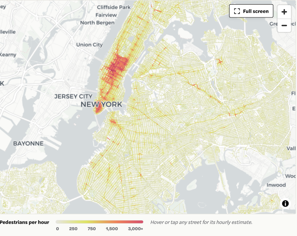
“Walking, after all, is not a niche activity. It is the connective tissue of urban life. It links transit to destinations, homes to neighborhoods, individuals to one another. It is also the most equitable mode of transportation we have. To take it seriously — to measure it with the same rigor we have long applied to driving — is to begin to see cities more clearly. And perhaps, in doing so, to design them more wisely.” – Andres Sevtsuk

On this subject, I wonder about all of the private driveways (residential and commercial) that cut across sidewalks often with slopes that make them ADA noncompliant and certainly dangerous for many users. Especially when new ones are illegally installed, what are the policy and ethical considerations for reporting these to the City?
Replacing them may cost homeowners thousands of dollars for an illegal driveway that could have been installed before they bought the house, but I feel like they are some of the worst offenders for Sacramento’s walking quality on many critical arterials.
LikeLike
Good comment. Driveways are absolutely a key part of sidewalk inventory and usability. I will add that to the post. I have reported sloped driveways that were new installations, but not old ones, from pre-PROWAG.
LikeLike