In preparation for some exploration of funding sources for roads, it helps to see what the situation is with the jurisdictions and types of roads, for mileage and VMT.
Jurisdiction means the level of government responsible for the road. This is not always clear from simply looking at a road. If there is a federal or state highway sign, it is pretty clear, but there are roads that are part of the state highway system that are not signed as such.
The types of roads, here, means functional classification, which is a federal designation of Interstate, Principal Arterial – Other Freeways and Expressways, Principal Arterial – Other, Minor Arterial, Major Collector, Minor Collector, and Local. Again, it is not always easy to distinguish classification, but as a generality, freeways fall into the first two, major roads such as Folsom Blvd and Watt Ave fall into the third, busy wide streets are the next three, and residential streets are the last. Another useful classification is that the first six categories are roads, meant to move motor vehicle traffic, and the last is a street, meant to provide access to residences and small businesses. Unfortunately, we build far too many of the road variety and then put business on them so they no longer function well to move cars. See Strong Towns for a more detailed explanation of roads, streets, and stroads.
Lane miles are centerline miles times the number of lanes. For example, a four lane road would have four lane miles for each mile of road. Centerline miles are not charted here since the discussion is leading towards how we maintain our roads, and lane miles are the more important measure.
VMT is vehicle miles traveled. The number in the data source is actually annual vehicle miles traveled. VMT relates to both possible sources of income and to roadway impact that requires maintenance.
The source of the data is the Caltrans report, California Public Road Data 2014.
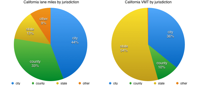
First, California lane miles and VMT by jurisdiction.
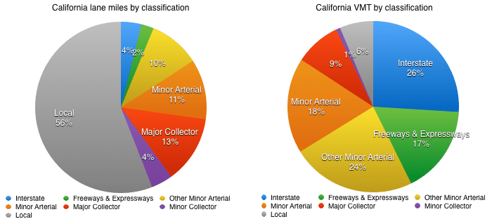
Second, California lane miles and VMT by functional classification.
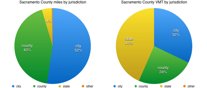
Third, Sacramento County miles and VMT by jurisdiction.

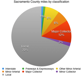
And fourth, Sacramento County miles by functional classification. I have not so far been able to locate VMT data by functional classification.
So, what does this all mean? The state has relatively few lane miles but carries most of the VMT, and therefore has high maintenance costs, particularly since a lot of this traffic is heavy trucks that cause far more damage to roadways than other vehicles. The cities have most of the lane miles but relatively less VMT. Counties are in between, with a lot of lane miles on rural and exurban roads but relatively less VMT.
In Sacramento County, the cities (Sacramento, Citrus Heights, Elk Grove, Folsom, Galt, Isleton, and Rancho Cordova) have a bit more than half the half the mileage), and the county has most of the rest. VMT is pretty evenly split between the cities, the county, and the state. The vast majority of roads in the county are classified as local. Data for VMT by functional classification has not been located yet.
More to come…

Cool article, Dan. Thanks!
James Drake Service Planner Sacramento Regional Transit 916-556-0505 | jdrake@sacrt.com
WordPress.com >>> Getting Around Sacramento 11/11/2016 1:05 PM >>>
Dan Allison posted: “In preparation for some exploration of funding sources for roads, it helps to see what the situation is with the jurisdictions and types of roads, for mileage and VMT. Jurisdiction means the level of government responsible for the road. This is not alway”
LikeLike