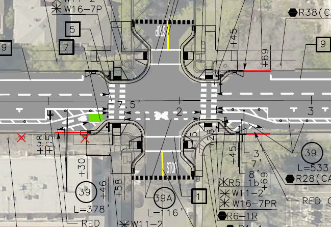
More information on the curb extensions (bulb outs) being installed on the northeast and southeast corners of the intersection of 19th Street and O Street, as part of the Central City Mobility Project. I questioned this location for curb extensions because 19th Street with have a parking protected separated bikeways on the left side (southbound) of 19th Street. (Central City Mobility update)
I received a response from the engineering firm for the project:
This is in response to your inquiry as to compatibility of the subject intersection revisions and parking protected bike lane. The design does account for the bulb outs at the intersection. Unfortunately, due to the space restrictions resulting from the bulb outs, it won’t be possible to provide parking protected all the way around the bulb outs. However, we are providing a transition of the bike lane at the intersection. Please take a look at the following striping design for the intersection. North is to the right with 19th Street running left to right. Hopefully this will give you a better feel for the plan:
Any reader of this blog will know that I love curb extensions. What confuses me is why this location would have been selected by the city over many other potential locations. Perhaps some of the reason it that the crossing at O Street has a moderately high walker count, but does not otherwise have a traffic signal or pedestrian signaling such as a RRFB. It is possible that the city thought these four corner curb extensions to be the most practical way of increasing safety for walkers and bicyclists crossing at this point.
The design of bringing the separated bikeway out adjacent to the general purpose travel lane, as a bike lane, is not ideal but not particularly unsafe. In fact some bicyclists prefer this design, because it increases the visibility of bicyclists by motor vehicle drivers, so that they are not ‘hidden’ behind parked cars. Though daylighting of the intersection approach can accomplish the same objective.
I would like to see green skip paint continuing through the intersection in the bike lane. These are often painted as discontinuous green rectangles with sharrows stenciled on top, called green-backed sharrows. The sharrows are out of favor with most bicyclists and some traffic engineers, I think this is a valid use of them. The main purpose of green paint (it has no legal meaning) is to increase driver awareness of bicycle facilities by highlighting conflict points, and this is definitely a conflict point.
The City of Sacramento’s Central City Mobility Project is underway, and projected to finish by next May. The map below shows the major components of the project: new parking protected separated bikeways on 19th Street and 21st Street between W Street and I Street, extended parking protected separated bikeways on P Street and Q Street from 15th Street to 21st Street, a separated bikeway (not parking protected?) on I Street from 21st Street to 12th Street, and conversion of 5th Street from a one-way street to two-way from Broadway to I Street (the two-block section from L Street to J Street is already two-way). The project also includes upgrades of corner ramps to ADA compliance along 21St, 19th, P, Q and I streets. I notice that ramp upgrades are also occurring at some locations other than these streets, whether under this project or a separate initiative, I’m not sure.
Central City Mobility Project map
As far as it goes, this project looks to be great. The city is making an effort to create a grid of higher quality bicycle facilities in the central city, of a mile spacing, or less. But a bicycle network is only as good as it’s weakest spot, and this project leaves several weak spots in the grid. The map below highlights some of these, shown in cyan color:
P Street and Q Street parking protected separated bikeways should be extended west to 5th Street, which would include a reduction of lanes on those streets. Stopping the bikeways at 9th and 10th Street reduces access to Sacramento Valley Station, as well as many other destinations in this area, including using the Tower Bridge to access West Sacramento.
9th Street parking protected separated bikeways should be extended from Q Street south to Broadway, to provide access to the higher quality bikeway along Broadway, and points south of Broadway.
I Street separated bikeway should be extended from 12th Street west to 5th Street, created a complete bikeway from 21st Street to Sacramento Valley Station.
J Street parking protected separated bikeway should be extended east from 5th Street to 19th Street, to proved a complete bikeway from 5th Street to 28th Street.
A separated bikeway should be constructed on 28th Street to provide a high quality bike route parallel to the unsafe 29th Street one-way southbound traffic sewer and 30th Street one-way northbound traffic sewer.
Regular bike lanes, at a minimum, should be installed on 13th Street between P Street and Capitol Park. 13th Street is one of the most heavily bicycled north-south routes in the entire central city, but this two block gap makes that trip less safe.
It is also possible that the P Street and Q Street bikeways should be extended east at least to 28th Street, or beyond, but I haven’t looked closely at that yet.
Central City Mobility Project map with recommended additionsRead More »
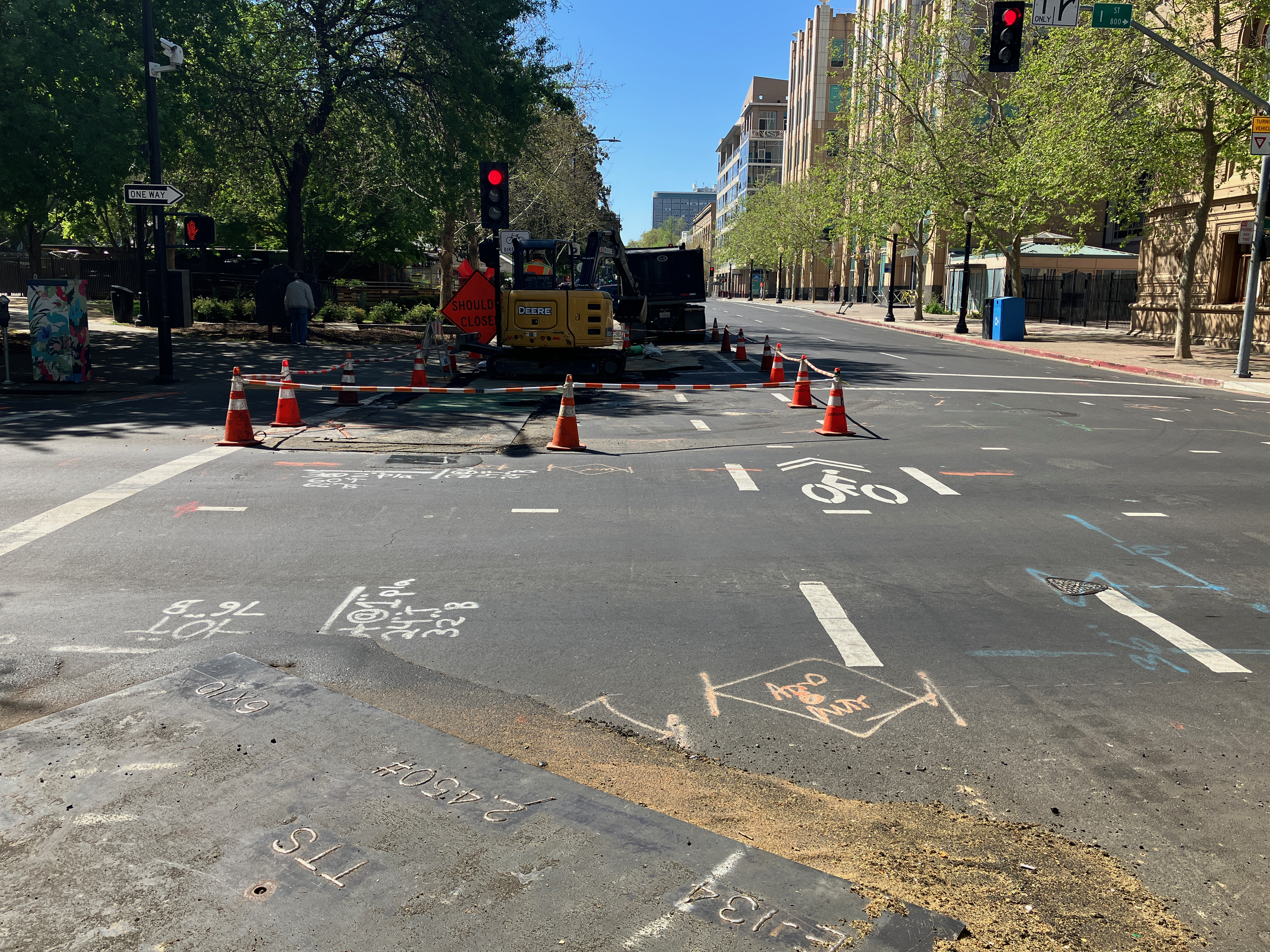
The repaving of 21st Street between W Street and I Street is complete. The section has been marked with ‘temporary road marker tabs’ (these have various names). The marking is for parking lanes on both sides, of eight to ten feet, and ultra-wide general purpose travel lanes, of at least 16 feet. No bike lanes were marked, though the street previously had marked bike lanes. A typical move on the part of the city and its contractors, to take care of motor vehicle travel and parking, but forget about bicyclists. This is of course temporary, but state and federal law require accommodation of bicyclists in construction zones. No such accommodations was made.
21st St between J St and I St, ultra-wide travel lanes, parking lanes, NO bike lanes
There are temporary paint markings for the first several blocks north of W Street, showing what the paint configuration will be. The parking protected separated bikeway is, as was likely, on the left side because most of this stretch has bus service on the right. The bike area is about seven feet wide. The buffer strip of about three feet wide, and the parking lane is about eight feet wide. The buffer may or may have vertical delineators (soft hit posts) continuously or at conflict points. There is no indication at any location, so far, that there will be hard curbs to actually protect bicyclists when parked cars are not present. For information on why a seven foot bikeway is not sufficient, please see bike lane widths. NACTO recommends at least eight feet.
21st St temporary marking for separated bikeway
As I rode up 21st Street, I noticed that the bus stop is marked in the same way that the parking lane is. I hope this is just a temporary mistake, otherwise there will be parking in the bus stop despite the red curb. The city is still failing to do two things it can to better support transit: 1) install concrete bus pads so that the weight of the bus at the stops does not distort the pavement and cause potholes, and 2) paint the pavement red at each bus stop so as to make it clear that this is a place for buses only, and not private vehicles. And, yes, it would be nice if transit islands were installed so that the bus does not need to pull out of and then into traffic. The city keeps saying that it supports transit, but doesn’t actual do anything to support transit.
21st St bus stop, marked as though it were a parking lane
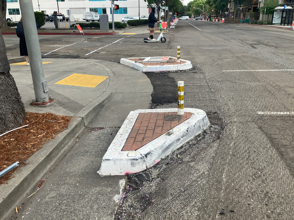
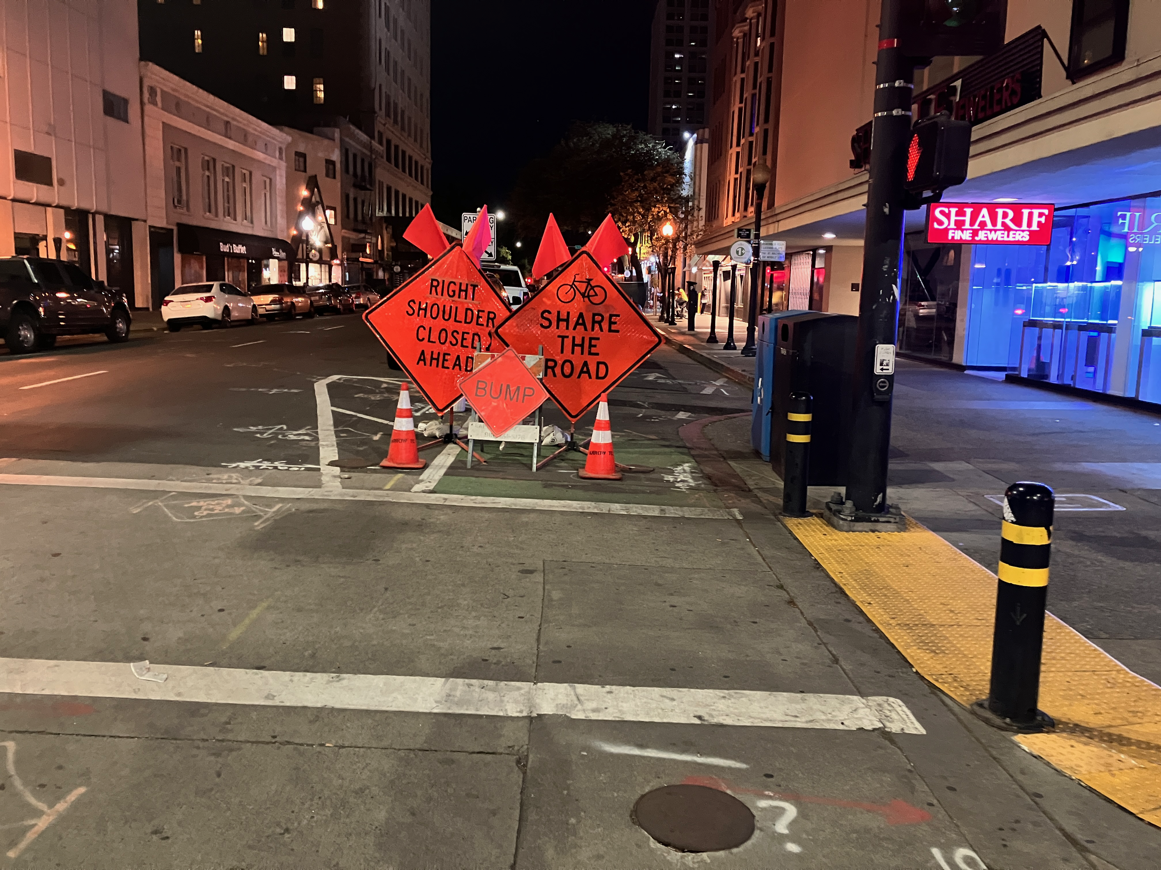
Lastly, in the category of ‘be careful what you wish for’… I had wondered why the city was not taking advantage of the ADA ramp project to put in curb extensions (bulb-outs) at some critical intersections for walker safety. This afternoon, I noticed that they are putting in curb extensions on the northeast and southeast corner of 19th Street and O Street. Yay? Nay? The problem is that the location of the extensions would extend into the separated bikeway on the left side of 19th Street southbound. The photo below, looking north along 19th Street at O Street, shows the extension under construction. There is supposed to be a curb-adjacent, parking protected separated bikeway here. I assume that bus stops for SacRT Route 62 southbound will be on the right hand side of the street, and the separated bikeway on the left hand side. Is there anyone paying attention? Anyone? Ferris? Anyone?
I now know why all the of initial ADA ramp projects were on 21st Street. That is the first street being repaved as part of the Central City Mobility Project. 21st has been identified in the project for separated bikeways. Since there is a bus route on 21st (SacRT Route 62), I assume that the bus stops will be on the right hand side northbound, and the bikeway on the left hand side. The design shown on the project webpage shows a parking-protected separated bikeway on the left, along with a buffer zone (to protect against car doors opening). This seems to be the standard that the city has adopted, and side so far the city is placing separated bikeways only on roadways that also have bus service, presumably this design will be used in every case.
Another diagram indicates that there will be vertical delineators (K-71) in the buffers, but there are no details about the frequency. There’s are the delineators that are run over and destroyed by vehicle drivers on a regular basis, and these will suffer the same fate. The larger diameter delineators (NOT bollards, the city is incorrect in calling vertical plastic a bollard; bollards are made of metal or concrete, not plastic) that are now installed on part of J Street are not specified here. Though these don’t provide any more actual physical protection, they seem to raise doubts among drivers and get run over less often.
There were several curb islands along 21st Street on the left hand side. All but one have been removed. The remaining one at 21st Street and Capitol Ave may just be an oversight, but if not, it is in the middle of what is expected to be the separated bikeway.
Sac_21st-St-Capitol-Ave-SW_curb-islands
The fourteen blocks of 21st Street from W Street to H Street has been stripped down about two inches, for repaving. The restriping after paving will include the separated bikeway.
The project webpage has a diagram for the transition of a separated bikeway on the left side of 19th Street southbound to the right side of 19th Street south of W Street, which is a two-way street. However, it does not have a diagram for the transition of this 21st Street separated bikeway at the north end, where 21st Street becomes a two-way street at I Street. This is already a hazardous intersection due to the double left-turn lane from 21st Street to I Street westbound.
Separated bikeways are only as safe as their intersection treatments, and the transition from and to separated bikeways to regular bike lanes are critically important. I hope that the city has a good design for 21St Street and H Street, otherwise bicyclists will be placed in more danger than existing conditions. The solution is of course bicycle signal faces that allow bicyclists to move when other traffic is held, but the city has been reluctant to use these.
Bicycle facilities will be provided within 1/4 mile of every origin/destination
Regular bike lanes (Class 2) may only be used where design and posted speeds are 30 mph or less
Separated bikeways (Class 4) will:
be used for design and posted speeds above 30 mph
have a minimum width of 8 feet, to accommodate passing and wider devices
use hard curb protection where parking protection is not available, or parking utilization is low
Signals
Bicycle signals will be used as necessary to ensure safe crossing of intersections, appropriate priority for bicyclists, and safe transitions to and from separated bikeways
Signals at intersections will detect bicyclists in any lane
Streets that host large volumes of bicyclists in general purpose lanes or bike lanes will have signal timing for a green wave, accommodating bicyclist speeds of 12-15 mph and slowing motor vehicle traffic
Parking
Parking for shared mobility devices will be provided in sufficient quantity on wide sidewalks (over 8 feet) or in the street
On-demand bicycle parking (BikeLink or equivalent) will be provided at locations where bikes are commonly parked for more than two hours
The city will work closely with transit agencies to ensure that bus stops with significant bicycling first mile/last mile have sufficient bike parking
Transit
All bus routes with 30 minute frequency or better will have bus boarding islands with bike lanes or separated bikeways passing behind the island; shared bus/bike lanes will only be used to distances of not more than one block, in order to solve right-of-way issues
Streets that provide long distance travel on with low volume and low speed motor vehicle traffic will be designated as bike boulevards, with appropriate marking, signing, and traffic calming treatment
Shared mobility will be managed and/or owned by the city or transit agency with sufficient control to ensure social and transportation objectives, and stability
Design diagrams will include:
Bike lanes (Class 2)
Separated bikeways (Class 4)
Bike boulevards
Contra-flow and two-way cycletracks, for use where safe bicycle facilities are not
The City of Sacramento started a design with protected bikeways on streets with significant bus traffic on P Street and Q Street in downtown Sacramento. I live on P Street, so see use of the bikeway on a daily basis. It works OK. P and Q are not heavily biked streets, and the separated bikeways are not heavily used, but they are OK. And actually, P Street doesn’t work well for buses. Since much of the bus traffic is commuter buses, a lot of them over a short period of time, there is often a stack-up of buses blocking traffic and interfering with each other at a stop opposite me on P Street at 13th Street.
Note: I’m using the term separated bikeway here because it is the term in state law, and therefore planning and engineering documents. Most people call these protected bike lanes, or sometimes cycletracks, though the term cycletrack is more commonly used for two-way bike facilities. Use whatever term you’d like!
On Q Street eastbound, the separated bikeway transitions to a bike lane at 14th Street. Since there are bike lanes on both sides of Q Street to the east, a bicyclist a decide where to transition to the right side of the street. This works OK.
On P Street westbound, however, it is a completely different story. The separated bikeway ends at 9th Street. To the west there are no bicycle facilities of any sort. It is a three lane traffic sewer (what I can three or more lane roadways, the purpose of which is solely to flush traffic in and out of downtown). With the construction going on all through downtown, P Street is and has been reduced to two lanes is several places, and with state workers mostly working from home, there is much less traffic in downtown. Nevertheless, the design is fatally flawed. I use the term ‘fatally’ on purpose – it is a design likely to result in bicyclist fatalities.
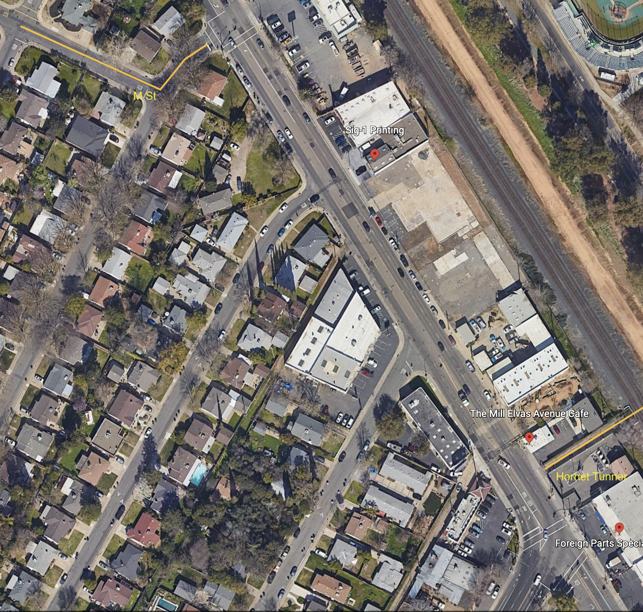
I have long been planning to write about the extremely poor bicyclist facilities from M Street to Hornet Tunnel, which is a major access point for Sac State.
M Street is a major east-west bicycle route, with some but not all of it marked as a bicycle route. If the city used the bicycle boulevard designation, it would be designated a bicycle boulevard. M Street forms an uncontrolled T-intersection with 62nd Street, which leads a short way left to a signalized T-intersection with Elvas Ave.
Hornet Tunnel is a major access point to Sac State campus, probably second only to the Guy West bridge access on the north side.
The map below shows M Street, 62nd Street, Elvas Ave, and Hornet Tunnel, as it exists.
The route from M Street to Hornet Tunnel is heavily used by bicyclists, both students and people passing through to the American River Parkway paths. It would be much more heavily used if it were safe, but it is not.
Eastbound to campus, one must cross over four lanes somewhere between 62nd Street and the median along Elvas Ave, and then ride on the wrong side of the street to reach Hornet Tunnel. Westbound, it is not bad, only having to merge over the northbound lanes to a dedicated left turn lane to 62nd Street. The signal here is surprisingly responsive to bicyclists, so the wait is usually short.
At the 62nd Street & Elvas Ave intersection, Elvas is 62 feet wide, 70 feet with sidewalks. There are shoulder stripes setting off unofficial parking, one southbound lane, one center turn lane, and two northbound lanes. At 64th Ave, Elvas is 68 feet wide, 76 feet with sideewalks. At Hornet Tunnel, Elvas is 63 feet wide, 77 feet with sidewalks, with two northbound lanes and three southbound lanes, two of which are dedicated right turn lanes to 65th Street. Elvas was formerly wider at Hornet Tunnel, but some sidewalk was added there to ease crowding at the tunnel entrance/exit. Given the city-preferred, though unnecessarily wide 11 foot travel lanes, there is room for six lanes of traffic here! That means there is ample room for bicycle facilities. But there are none present.
Some bicyclists take the striped shoulders to be bike lanes, but they are not. The city’s 2018 Bikeway Master Plan shows this section of Elvas between 65th Street and Hornet Tunnel as a Class 2 (on-street) bike lane, but this is false. It is not indicated as such with either pavement markings or signage. Though the shoulder stripe southbound has the dashed marking often used to indicate a bike lane approaching an intersection, this is a fake. It is NOT a bike lane. People park along this stretch, so even if it were a bike lane, it would not be safe nor meet minimal standards for a bike lane.
Solutions
What street redesign and reallocation would make is safer for bicyclists?
First, for northbound bicyclists, there should be a separated bikeway on the right side of the street. Along this section, there are four driveways and a stretch of street-oriented perpendicular parking (where vehicles enter directly into parking spaces from the street). There is a section of 270 feet with no existing buildings. Though there could be parking protected bikeway along here, I don’t think the parking is even needed. Instead, this is probably a good location for a curb separated bikeway, with hard curb to prevent encroachment on bicyclists. The curb would be cut only for driveways which are currently in use. The existing parking along this stretch is used mostly by students to avoid paying on-campus parking fees. All the businesses have onsite parking. The one business that might reasonably need short-term parking on Elvas is The Mill coffee shop. Separated bikeways work best with long stretches without driveways, but one here is workable.
Southbound is more complicated. If there were a bike lane or separated bikeway on the southbound side of Elvas, bicyclists would still need to cross to Hornet Tunnel, at a location where there is currently no way to do so. I see three options:
First, have bicyclists ride south to the existing 65th Street & Elvas Ave intersection, and use the crosswalk on the north side to cross over and then go north to the tunnel. This is very awkward, out of the way, and encourages bicyclists to use a crosswalk, which is not illegal but poor practice.
Second is to create a two-way separated bikeway (often called a cycletrack) on the east side of Elvas, from 62nd Street to the tunnel. A separate bicyclist signal phase would need to be created for northbound bicyclists to cross to 62nd Street, and southbound bicyclists to cross to the east side of Elvas Ave. An advantage to this solution is that parking on the west side of Elvas does not need to be changed, though it can be reasonably argued that there should be at least a regular bike lane here for bicyclists who are not going to the tunnel, but continuing south on Elvas or south on 65th Street.
Third, have bicyclists continue southbound on Elvas, but create a clear zone for crossing to the tunnel by signalization. Northbound motor vehicles would be held by the existing signal at the intersection of 65th Street and Elvas Ave, while southbound motor vehicles would be held at a stop line just north of the tunnel by new signal heads. Bicyclists would cross to the tunnel during the red phase. There would need to be queuing area for southbound bicyclists, since they would exceed the stacking capacity of the bike lane during busy times. This option probably slows motor vehicle throughput more than the other options.
No matter which solution, the sidewalks along Elvas Ave should be repaired and widened, and street trees should be planted. And of course the street needs to be repaved.
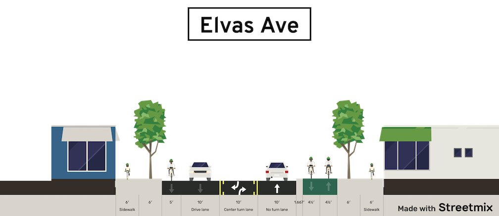
Below is a Streetsmix diagram showing one possible configuration (looking north) with a two-way separated bikeway (cycletrack) on the east side, along with wider sidewalks and trees in a planing strip, and a southbound regular bike lane. And yes, all this fits in the existing over-wide Elvas Ave right-of-way!
I am getting so, so tired of people on Twitter, bicycling advocates, who see bikes and bikes only as the solution to everything.
These are people who believe that it is always best to remove on-street parking in favor of bike lanes, whether regular or separated bikeways. In fact, they are always looking for roads on which to install bike facilities and remove parking, because they get off on the idea of removing all parking. A lot of advocates want bike lanes on every street.
Well, I disagree.
If there is a situation where existing or future bicycling use should be accommodated, and the only way of doing do it is to remove parking, then I’m in agreement. But that is often not the case. On any street with more than two lanes, it is almost always better to remove a travel lane (called general purpose lanes) than to remove parking.
Parking does (at least) two things:
Calms traffic by creating perceived friction, which slows drivers down. It is moving vehicles, quite often moving well over the posted speed limit, that are a hazard to bicyclists, and everyone else. It is not parked cars (not ignoring the issue of door-zone bike lanes).
Provides places for customers to park who so far have not shifted to walking and bicycling, or who are in that rare situation of needing a car for disability reasons or items being picked up/dropped off.
Sure, we need less parking than we have, but no parking is not the solution. If there is no on-street parking, then it increases the demand for surface parking lots, which are the worst possible land use in cities, or for structured parking (parking decks) which are the most expensive type of parking to build, and almost always require taxpayer subsidy. Both of these also produce almost zero property tax and sales tax.
I’m also in favor of managed parking, so that it is never free, and costs enough so that there will always be some empty spaces available, and that drivers are paying market value for parking, and for the cost of the pavement and maintenance they are using. I’m also in favor of designated passenger drop-off/pick-up curbs and unloading/loading curbs for commercial use. We do have too much parking, and way too much free parking. We should have less.
For those who I haven’t convinced, or have made angry (no doubt), please read The High Cost of Free Parking by Donald Shoup, and Walkable City by Jeff Speck. Both recommend retaining parking, but managing it better, in most situations. And removing it when there is really a good justification. Donald Shoup has conducted more research on parking than anyone, and Jeff Speck has designed more projects to improve walkability and livability than most.
Lastly, let me say I hate cars and hate most car drivers. The world would be a better place if we had about 5% of the cars we have now. The world would be a better place if almost all people walked or bicycled for almost all trips, and used transit for the few others. But I think it is dangerous to just remove all parking without looking at the situation on the ground, which includes all modes and everything that is adjacent to the street, including businesses.
Note: As is not unusual, I had forgotten that I’d written about N St before: N Street bike route to cycle track, 2015. Seven years have passed, the city has taken no action.
The construction for the Capitol annex project has narrowed N St to two lanes eastbound, from 10th St to 14th St, and parking has been removed from the south side to shift the lanes over. Now is the time for the City of Sacramento to implement its long-delayed (if not deep-sixed) plans for re-allocating space on N St. There have been ongoing utility projects over the last few years that have narrowed N St to two or even just one lane. At no time did that create significant congestion, during the pandemic or before the pandemic. I live two blocks from N St, and both travel along it and cross it frequently. I’ve never seen more than momentary congestion, in 11 years. What that means is that N St, in its three-lane configuration, has grossly excess capacity for motor vehicles.
While the street has been narrowed is the time to redesign the street so that it has no more than two general purpose lanes, and has a curb-protected or parking-protected bikeway. Probably on the left. This is in fact the perfect setting for a separated bikeway, five blocks from 10th St to 15th St with no intersecting streets from the north side, which is Capitol Park.
It is true that the sidewalk on the north side of N St is a designated bikeway, so bicyclists may use the sidewalk to avoid riding in the street. But bicyclists on the sidewalk are often in conflict with people walking on the sidewalk. The sidewalk has pretty continuous use by walkers, particularly during the lunch time – walk time for state workers, but a lot of people also include a circuit of the Capitol Park on their runs and walks. This conflict is easy to solve: create a safe, welcoming, protected (separated) bikeway on the street. And do it now!
On N St eastbound, the leftmost lane is a designated left turn lane at 10th St, which is what makes possible the two-lane configuration beyond 10th St. As a temporary measure, this works well, and forcing turns off three lane streets is a good solution for so many overbuilt arterials roads in Sacramento, but here it is only temporary, and would be obviated by the conversion of all of N St from 3rd St to 15th St. N St becomes a two-lane street at 15th St, and then becomes a two-way street at 21st St. N St from 15th St to 21 St would probably be a good candidate for a separated bikeway as well, but with paint bike lanes existing, would be a lower priority.
Below is a StreetMix sketch of what N St might look like. Note that the width of the street and the elements are estimated, not measured. I don’t believe parking is needed on both sides, but the diagram shows it for people who think it is necessary. Left side is north, Capitol Park in this case, and right side is south, mostly state buildings.
N St Sacramento between 3rd St and 15th St
As a reminder, I feel strongly, and it is backed up by evidence:
Three-lane streets are significantly less safe than two-lane streets, primarily for the muli-lane threat (one vehicle stops for walkers and the others do not). They are also a clear sign of poor land use planning, which puts residents and the things they need to reach (jobs, stores, recreation and entertainment, medical, etc.) far away. Narrowing all such roadways in the city from three to two, or less, would increase safety, increase livability, and encourage people to make different choices about where they live and visit. Maps of collisions (vehicle vs. vehicle, vehicle vs. walker, vehicle vs. bicyclist) align almost perfectly with overbuilt arterials.
One-way streets are significantly less safe than two-way streets, for the same multi-lane threat, and because there isn’t any friction to slow drivers. However, I think that the only valid argument for one-way streets is to accommodate separated bikeways, bus lanes, or rail transit. That may be true of N St.
And, sorry, can’t resist, get rid of the worthless palm trees while they are at it. We need shade trees, not poles.
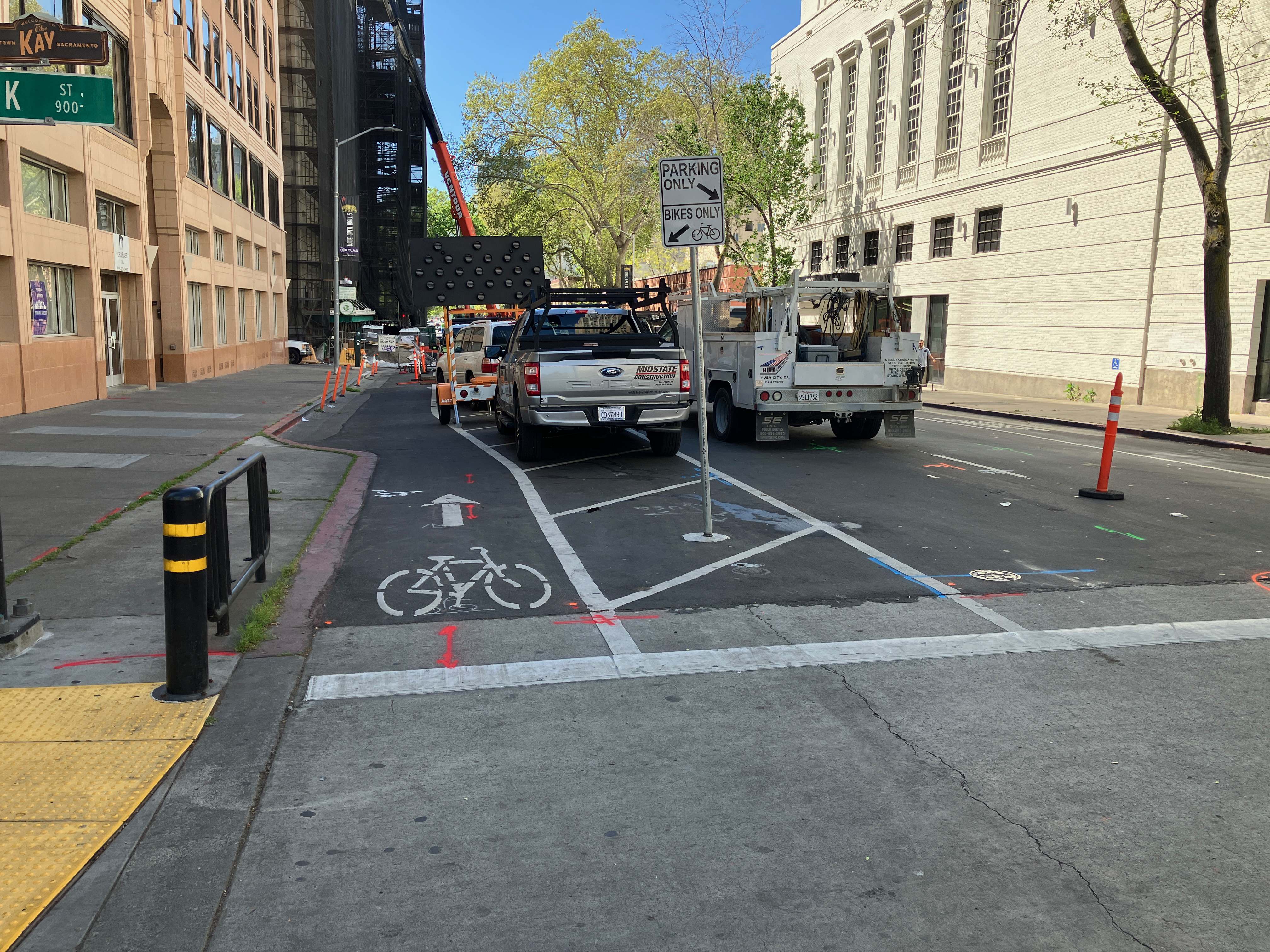
There are active utility projects on 9th Street and 10th Street that have closed parts of the separated bikeways on those streets. Upon noticing this, I thought, no big deal, a few days of work and things will be back. But the closures have been continuing for three weeks now, with no end in sight. It is interesting that the utility work on J Street is moving fairly quickly, but on 9th and 10th, not so much. I am not sure what utilities are being worked on, and whether these are city-led projects with contractors working on city-owned utilities, or whether they are private utilities such as PG&E or communications.
When there is an extended closure of a separated bikeway, more than two days, an accommodation for bicyclists should be provided. I am aware that some bicyclists are willing to ride in the traffic lanes, but the entire point of a separated bikeway is that it needs to work for all bicyclists, including people who are not comfortable riding in traffic. To allow construction to close a bikeway, without any alternative, is a failure on the part of the city. The city is again expressing its favoritism for motor vehicle drivers over bicyclists.
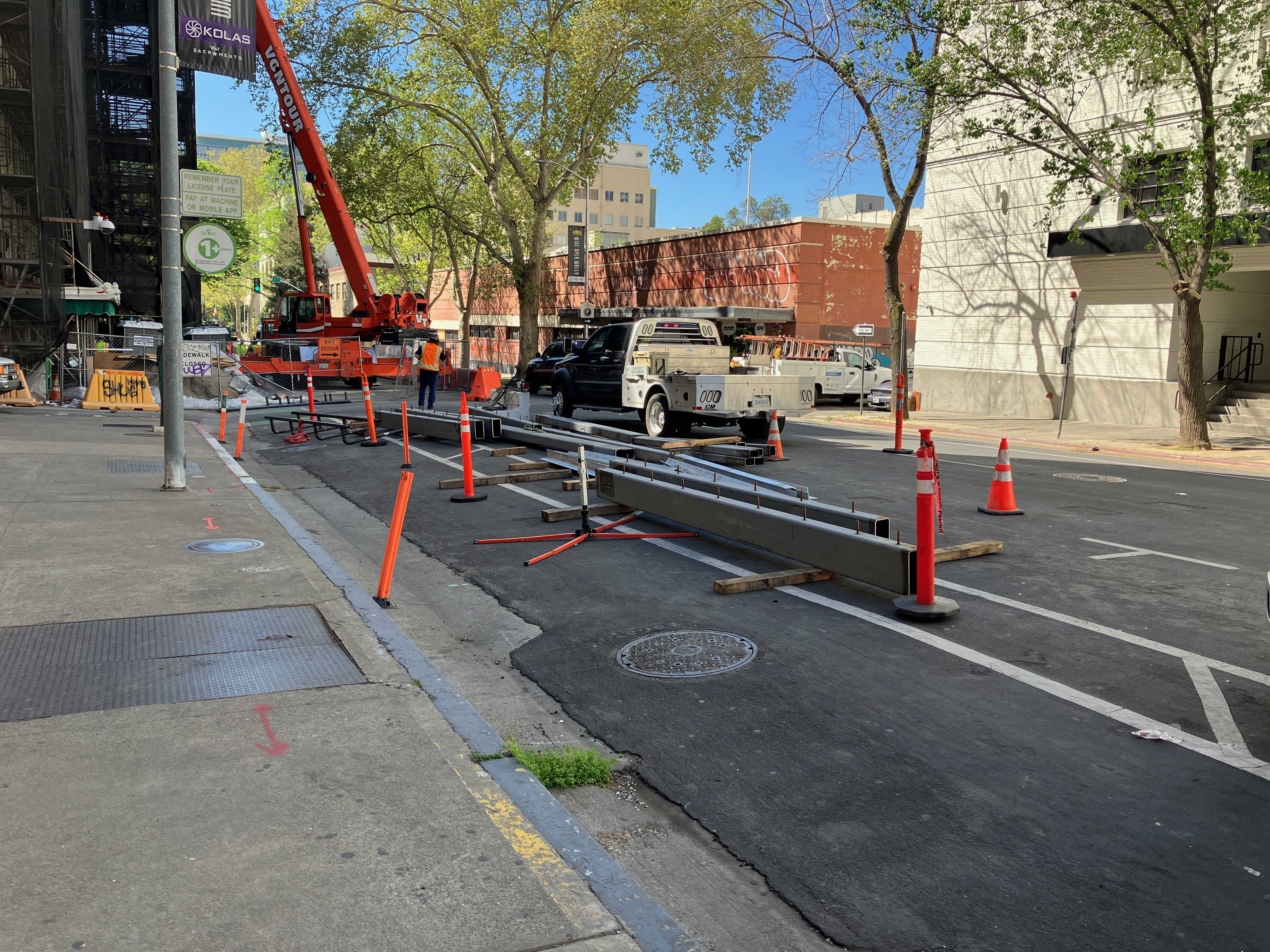
10th Street
10th St at K St bikeway closure10th St bikeway construction plate
For 10th Street, general purpose lanes should be reduced from two to one, making the other lane a temporary bikeway. Or, remove parking from the left (west) side of the street so as to allow two general purpose lanes and one temporary bikeway.
9th Street, H Street to J Street
9th St at H St bikeway/bike lane closure9th St at I St bikeway/bike lane
The bike facility on 9th St is not technically a bikeway until it crosses J St, but since it is intended to provide a similar safe route of travel, I’m including it here. Utility work has closed off the bike lane between H St and J St. No alternative has been provided. The solution is to remove one general purpose travel lane and create a bikeway, or remove parking on the right (west) side of the street in order to maintain two general purpose lanes and one bikeway.
9th Street, K Street to L Street
9th St at K St, no signing for bikeway closure9th St construction materials stored in the bikeway (just south of previous photo) 9th St at Kayak Alley, walkway/bikeway gone
The reconstruction of Capitol Park Hotel, on the east side of 9th Street between Kayak Alley and L Street, has been going on for months. Every time I go by, something has changed about how the roadway is being handled. Today, the safe bikeway and walkway that was there is now gone. Construction has pushed the fence up against what were formerly the barriers that separated the bikeway/walkway from traffic. Today there was a crane filling the space, which may be necessary, but that doesn’t change the clear message that the entire area is now construction zone with stored construction materials.
The section between K St and Kayak Alley is now being used to store construction materials and worker vehicles. The closure of the separated bikeway is not signed in any way; there have been signs here in the past, but they are gone. If you rode the bikeway without realizing it was closed, you would crash into construction materials.
I am not sure whether there is enough space left in the roadway to provide both a separated bikeway and a travel lane. If so, it should be modified for that. If not, the travel lane should be closed until the construction footprint shrinks again to allow the original walkway/bikeway.
It should be noted that the city did not initially provide the walkway/bikeway on 9th Street, and it was only installed after considerably public outcry.
These locations are a fraction of the ones throughout the city where the city has decided that motor vehicle traffic must be accommodated, but walkers and bicyclists do not. The construction guidelines code that the public requested the city develop and implement have been back-burnered because the city has decided to use staff to apply for grants rather than solving current problems on the roadways. I get more frustrated by the city by the day. I don’t really think they care at all. The car-dominated city, which was created by city planners and engineers, is just fine with them.