Out riding yesterday on 2nd Avenue in Sacramento, I ran across this sign, on the south side between 22nd and 23rd streets. It pretty much says it all, though I have to add – “drive like you want your kids to have a future,” which pretty much means, don’t drive at all.
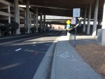
dead zone on 1000 block of J Street, downtown Sacramento
Why do buildings and lots sit empty for years throughout downtown Sacramento and beyond? Because there is little consequence to the property owner of leaving them empty. They continue to pay property taxes while waiting for some development scheme that will make them so much money that the years of property tax are a drop in the bucket. Occasionally, a property is taken for non-payment of property taxes, but that is rare.
While the building or lot remains empty, the city (I’ll use “the city” for the cities and counties and utility providers) still has costs associated with the property. The cost of electrical, water, sewer, telephone, the street network, and transit in an area has more to do with the capacity of the system and the network passing by a property than the specific connection to the property, so the city still has costs even though they are receiving only a pittance of property tax. Fire and police services are actually higher for empty building and empty lots because they attract vandalism, crime, illegal occupancy. They drag down the property values of everything around them, and therefore the property tax income from everything around them. They are in large part the very definition of blight.
Ironically, many of the empty buildings and empty lots in downtown Sacramento are owned by the city itself. So the city is costing itself money by letting these sit, and of course that means that it is costing us taxpayers.
When the economy slowed, those big projects that would make a lot of money evaporated, and so more and more property sat unused. But it did not need to be unused. Smaller scale projects were always possible. I think one of the big differences between downtown and midtown in the downturn was that midtown had a large number of small properties owned by people with moderate dreams of development and redevelopment, while downtown had a few large properties owned by people with grandiose dreams. Those dreams crashed, and so did downtown. A number of successful businesses were dragged down by the failures around them. Midtown went through a slow time, but lost far fewer businesses, and is now picking up in a way that downtown has not.
So, what to do? As always, I have some outside-the-box (or off-the-wall, some would say) solutions to propose.
1. Assess property tax on all government entities. What purpose would this serve? Wouldn’t it just be moving money from one pocket to another? Yes, but it would make the cost of maintaining empty buildings and empty lots show up on the balance sheet as a direct expense. As with all things financial, we pay it no attention until it shows up on the balance sheet and affects the bottom line.
2. Assess empty lots at the value they would have if developed, based on typical properties surrounding it. Seems unfair? Not in my mind. The empty lot is costing the city, and all of us, directly in terms of services needed, and indirectly in creating blight that lowers property values and depresses economic activity. This higher level of property tax would encourage the owner to move forward with development. In a few instances, these empty lots could be converted to public purpose such as a park or farmers market location, but the number of those conversions would be small relative to the number of properties
3. Double property taxes every four years for both empty lots and empty buildings. This would give the owner a strong incentive to do something. While regular property taxes can largely be ignored, when it goes up 2X, then 4X, then 8X, then 16X, no property owner will leave the property unused.
I have no illusions that even these radical proposals would bring vibrancy back to downtown, but along with many other policies and actions, they would certainly help.
I think something needs to be done about surface parking lots, which are another unproductive use of land that costs us all money, but that is another topic for later.
I’ve uploaded a few photos to Flickr of abandoned downtown, along J and K streets. It would take days and thousands of photos to document it all.
Walk Score offers an assessment of the walkability of any location. It is available in any browser at https://www.redfin.com/how-walk-score-works. The Redfin app shows walk score, bike score and transit score for each listing (scroll way down). Walk Score is based on the distance to the places people want to go, such as grocery stores, restaurants, coffee shops, bars, movie theaters, schools, parks, libraries, bookstores, fitness locations, drug stores, hardware stores, and clothing & music.
WalkScore has released for Sacramento a new walk score, 43, transit score, 33, and bike score, 68. New York is the top walk score city at 92, followed by San Francisco, Boston, Philadelphia and Miami. New York is the top transit score city at 81, followed by Boston, San Francisco, Washington DC, and Philadelphia. Portland is the top bike score city at 70, followed by San Francisco, Denver, Philadelphia and Boston. Sacramento compares very well in bike score, at 68, but poorly in walk score and transit score.
For the Sacramento region, walk scores in various neighborhoods range from 5 to 92 (of 100), transit scores range from 11 to 65, and bike scores range from 38 to 100. In general, the scores track with each other, walk friendly = transit friendly = bike friendly, however, there are exceptions. You can look up your neighborhood on the chart linked below, or go to WalkScore for a lot more detail on Sacramento. The top five neighborhoods are Boulevard Park, Downtown, Midtown/Winn Park/Capital Avenue, Marshall School and Mansions Flats, all in the city of Sacramento. WalkScore exists largely as a sales tool for houses and apartments, but it has broad applicability as well.
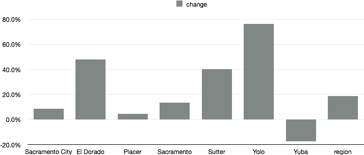
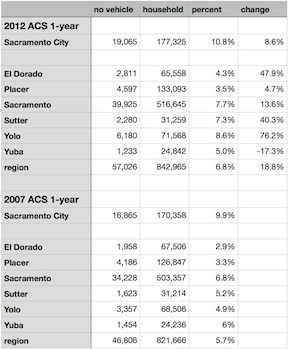
I read with interest the Streetsblog DC post “The American Cities With the Most Growth in Car-Free Households” and wondered about Sacramento. I dove into the American Community Survey, using the same 2012 ACS 1-year and 2007 ACS 1-year data that the research had used to look at the number of car-free households in other cities. Over the period when the national average increased from 8.7 percent share of households without a vehicle to 9.2, the six-county Sacramento region increased from 5.7 to 6.8. Not very impressive, but the change or delta was an impressive 18.8%. Yolo County, probably Davis, led this change with a remarkable 76.2% increase!
Below is the chart of change from 2007 to 2012, for the City of Sacramento, El Dorado, Placer, Sacramento, Sutter, Yolo and Yuba counties, and the region, which is an average of those six counties. Following the chart are the numbers I retrieved from ACS. If you would like to look for yourself, go to the ACS Advanced Search, and then under Topics select Housing > Occupancy Characteristics > Vehicles Available.
In the blog post, the largest major city increase was Detroit at 5%, and our neighbor San Francisco was sixth at 1.9%.
I’m not quite sure what to make of these numbers. Is there a flaw in my logic? I had to impute the no vehicle households from the total households and percentages for 2007, because the actual number doesn’t seem to be available in the data tables. Were the numbers so small in 2007 that such large changes don’t really mean much? I don’t know. Your thoughts?
The Draft Environmental Impact Report (DEIR) for the Entertainment and Sports Complex (ESC, or arena) was released a few days ago, and this evening there was a public workshop on the DEIR. About 70 people were in attendance, perhaps 1/4 of them city and consultant staff, and about 1/4 were wearing Kings supporter T-shirts or other Kings clothing. I recognized a few faces from the active transportation world, but many I did not know. A speaker gave a quick run-through of the DEIR, sort of executive summary of the summary section of the DEIR.
Following the introduction, people went to the stations on the topics covered in the DEIR to ask questions (and of course make comments, though that was not the purpose of the workshop). At least half the people gravitated to the transportation section, as it seemed to be their area of most interest. Probably parking is the issue most on the minds of Kings fans, but for many, the issues of pedestrian, bicyclist, and transit access to events, and the potential impact on these, are of great interest. Read More »
sactown magazine has an interesting series of articles grouped under Why Not Here? which I like for its thinking outside the box. Though most of these are not directly transportation related, they are about transforming the nature of Sacramento and bringing residents into downtown. Most of the articles were written by sactown co-owner Rob Turner.
I believe that these are important goals because it is only through dream-big projects that the money to fix our transportation woes will become available. If we have to wait until our regular tax base can fix things, we will be waiting a long time, but new developments can fix things as part of their design. Several ideas are about bringing regular and high-end housing to downtown, which encourages walking, biking and transit solutions rather than more driving and more parking.
Return of the JFDI (sactown 2013-12); this one is about the Community Center Theatre
Traffic circulation, for everyone, is handicapped or prevented by an incomplete grid system in downtown and midtown Sacramento. Three recent posts have addressed this issue, I’m thinking about several more, and several posts over the last year were also on the same topic. So I created a new category for the Getting Around Sacramento blog, re-gridding Sacramento.
Re-gridding is an awkward phrase, but I haven’t come up with a better one yet, so I’ll use it for now.
These photos are of the I Street entrance to Old Sacramento, showing various problems and hazards that exist for pedestrians and bicyclists at this location. The crosswalks here are not really safe. All sorts of signing has been installed to try to make them safe, but that is a poor substitute for correct design. The […]
In the last there days, Monday through Wednesday, at least four people died when struck by car drivers, and two others were injured. I know that the Sacramento Bee does not report all pedestrian and bicyclist fatalities and injuries, so there may have been more in the region, but this is an incredible level of slaughter.
The better of these articles describe the outcome and location in a factual manner. The poorer ones place the blame on the victim. This victim blaming is aided and abetted by the law enforcement officers who make the assumption that either a) it was a “tragic accident” that could not have been prevented or b) the driver was not drunk and remained at the scene, so clearly it is the pedestrian or bicyclist’s fault. Both are nonsensical statements and ideas.
A “green wave” is a traffic signal sequence set so that vehicles will encounter green lights for some distance, so long as they are traveling at the selected speed. A green wave can also be set for bicycle speeds, though it very rarely has been, and never in Sacramento.
To some degree, all signals are set this way, though the degree and distance of sequencing varies widely. Many of the east-west streets in the Sacramento grid have signals set for motor vehicles, and when traffic is not congested, it may be possible to go all the way across downtown and midtown on green lights, for example on J Street. Very few north-south streets are set this way, I can think of only the 15th & 16th couplet, and the 9th & 10th couplet. At intersections with the east-west couplets, these north-south couplets seem to have their green wave broken. Only if the grid spacing and the selected speed calculate out is it possible to have a green wave in all directions. Sadly, many signal sequences in the Sacramento region are set above the posted speed limit, encouraging drivers to speed so that they make all lights.
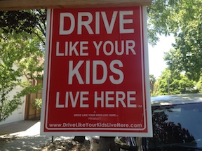 Out riding yesterday on 2nd Avenue in Sacramento, I ran across this sign, on the south side between 22nd and 23rd streets. It pretty much says it all, though I have to add – “drive like you want your kids to have a future,” which pretty much means, don’t drive at all.