City of Sac blind adherence to ADT

Another post on the Freeport Blvd Transportation Plan. See the category Freeport Blvd for other posts.

“We are designing for the traffic we have, not for the traffic we want.”

Ali Doerr Westbrook, Chair of Sacramento Active Transportation Commission

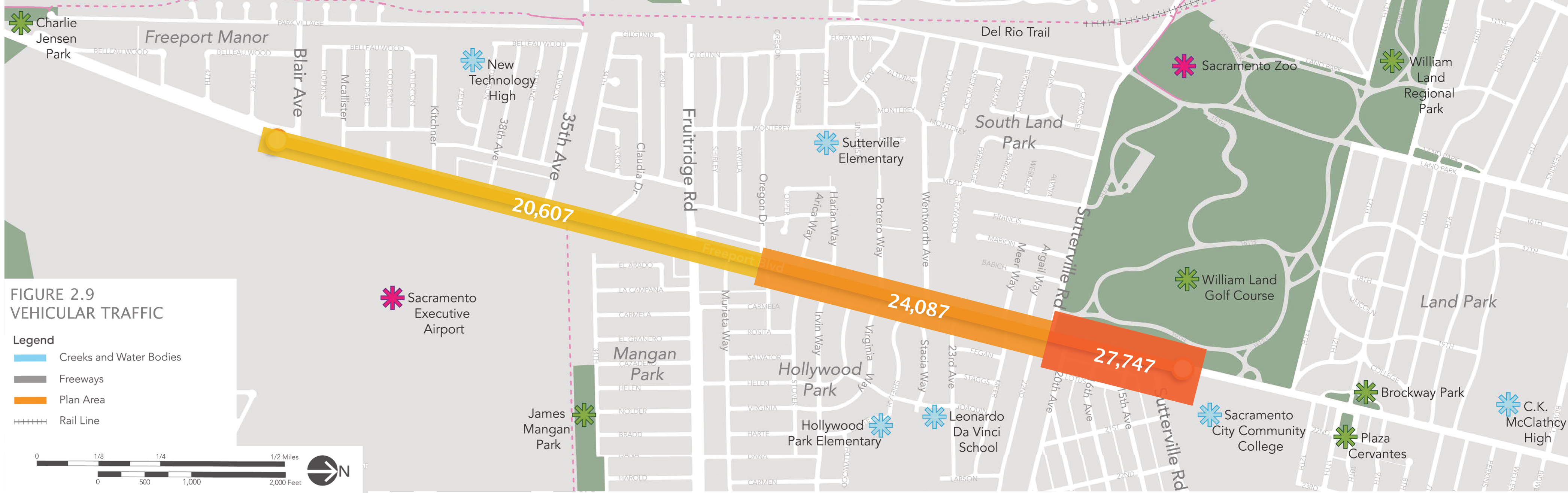
I could stop at that, but perhaps you’d like some more detail. This comment was made during the Sacramento Active Transportation Commission (SacATC) meeting on January 18, 2023. The context was the admission by the two city planners, Leslie Mancebo and Jennifer Donlon Wyant, that the city eliminated the possibility of a road diet (roadway reallocation) before even starting planning for Freeport Blvd. The reason expressed is that the ADT (Average Daily Traffic count) is above 20,000 for Freeport, and that requires more than two lanes (one each direction). Interestingly, ADT counts for various locations along Freeport are nowhere to be found in the plan or appendices. In a different location on the City of Sacramento website, Traffic Counts, the ADT for various locations along Freeport Blvd, rarely exceed 20,000, and have not exceeded 20,000 since 2011. There is no indication that the city even did new traffic counts in preparation for this planning effort. So far as can be determined, they just decided to not consider a road diet from four lanes to two lanes, or two+one lanes, 3/2 configuration) because they wanted to prioritize motor vehicle traffic over all other uses of the roadway.

The city planners also acknowledged that a road diet was a prominent request of the community during the planning process. But, community input be damned, the city is going to serve car drivers before anyone else.

A reduction of lanes from four to two is the single most important traffic calming effort that can be made on a roadway. That does not mean it is the appropriate solution for Freeport Blvd, or for all of Freeport Blvd in the planning area. What is does mean is the that city should have considered it in the planning process.

Back to Ali’s comment. The city is planning for a roadway configuration that should have already been in place years ago, before the city over-widened the roadway, and in several cases narrowed sidewalks to accommodate the widening. They are not planning for a roadway which would reduce vehicle miles traveled (VMT) or increase safety and access for those outside cars. The city’s responsibility, under the Mayors Commission on Climate Change report, is to reduce VMT in order to reduce greenhouse gas emissions (GHG), not to maintain VMT at current levels. But this Freeport plan is a plan to guarantee current VMT for at least 30 years in the future, which is about the length of time before the city will be able to reconstruct the roadway again, and correct the mistakes they made this time around.

The intent of the city in this plan is made very clear in the common design principles: “10. Maintained necessary travel lanes, turn lanes, and parking: Maintaining travel lanes and turn lanes ensures that drivers traveling along the corridor will not be compromised, and preserving parking spaces where 5 the utilization is higher so it serves better adjoining businesses.” Though this is the last item in the list of ten, it is clear that this is the highest priority for the city.

The refusal to consider a road diet/lane reduction/roadway reallocation is a fatal flaw in this plan. The effort should be sent back to staff to re-do. It should not be adopted by city council. If the city council does not reject this kind of flawed planning, city staff will continue to make the same mistake, again and again and again.

I’ll post on some of the other flaws in the plan, but this is the most important, not just because it misses the best opportunity for traffic calming, but because it retains roadway width for the exclusive use of motor vehicles that could be better used for walking, bicycling, trees, and even parking for businesses.

Added graphic below, which I had not noticed in the plan, that documents vehicular counts on sections of Freeport Blvd. Is it suspicious that half of the plan area is ‘just’ over the city’s criteria of 20,000 ADT? Remember, the plan itself and the city’s traffic counts website do not indicate this level of ADT.

Pedestrian safety countermeasures

In addition to the leading pedestrian interval recently covered, three other pedestrian safety countermeasures are given prominence (among a long list of potential measures with smaller but not insignificant benefit):

Medians and Pedestrian Crossing Islands in Urban and Suburban Areas: These medians provide a safe space for pedestrians to wait while part way across the intersection, and simplify the crossing by making so the walker only has to look at one traffic direction at a time. They are used both in mid-block and intersection settings. The photo is of a pedestrian island at Folsom and 48th in Sacramento. This is a location with frequent crossings, with popular businesses on the north and south side of Folsom. And with a popular bar on the north side, the importance of safe crossing is increased.

Pedestrian Hybrid Beacon: This is a specialized signal for mid-block pedestrian crossings that grabs the attention of drivers with a sequence of changing signal patterns that eventually goes to full stop. These are also known as HAWK signals (High intensity Activated crossWalK), invented in Arizona. I often hear complaints that these signals are confusing to drivers, but to me, that is exactly the point, it grabs their attention. Though I’ve seen these installed at intersections, this is a mis-application; they are designed for mid-block crossings. These signals are expensive, about 20% of the cost of a fully signalized intersection. The Rectangular Rapid Flashing Beacon (RRFB) is a much simpler and much less expensive alternative, but limited to lower traffic volume and lower speeds than the hybrid beacon.

Road Diet: A road diet reallocates roadway width from regular motor vehicles lanes (called general purpose lanes) to more constructive use such as wider sidewalks, bike lanes or separated bikeways, transit lanes, and sometimes parking – where it is really needed and calms traffic). The simplest to implement is the conversion of parallel parking to diagonal parking on overly wide streets, such as has been done a number of places in Sacramento central city. More complicated reallocations are often called ‘Complete Streets,’ though complete streets are not well defined, and adding sidewalks and bike lanes to 45 mph posted (55 mph actual) arterials with infrequent safe crossings does not encourage anyone to walk or bike and may be a waste of money. But in urban areas where the capacity of multi-lane streets is not needed, or needed for only a very small part of the day, a road diet may create a safer and walkable environment.

For a full list of pedestrian safety countermeasures, see Countermeasures.

crossing guard for DMV on 24th

crossing guard for DMV on 24th Street

The California Department of Motor Vehicles (DMV) has facilities on both side of 24th Street to the south of Broadway. Employees must go back and forth between the two facilities, but DMV does not think that it is safe for their employees to use the mid-block crosswalk without the extra protection of a crossing guard.

What are they being protected against? Well, drivers that have been licensed by DMV. Drivers who either do not know the law on yielding to pedestrians in crosswalks, or who choose not to follow it. Drivers who are distracted by cell phones. Drivers who drive over the speed limit. Drivers who are inattentive to their surroundings. You would think that maybe this hazard would cause DMV to reconsider their lackadaisical method of licensing motor vehicle drivers. Maybe drivers should be relicensed on a regular basis instead of receiving what is essentially a life-time license. Maybe drivers should have to demonstrate safe driving skills, knowledge of the law, and pro-social attitudes. Maybe. But DMV doesn’t seem interested in improving the safety of all roadways, but would rather solve a specific problem by using a crossing guard.

Another issue is that the street has been striped with a wide median in the center (not a physical median) to provide a place for the R1-6 Yield to Pedestrian signs and a refuge for pedestrians and the crossing guard. Normally this would be a good thing, but the wide painted median pushed the travel lanes to the side and pinches out the shoulder that is used by bicyclists. So in making things safer for pedestrians, the city has made things less safe for bicyclists. An appropriate trade-off if it were the only choice, but it is not the only choice. There is no logical reason for this section of 24th Street to be four lanes. To the north, it is two lanes, to the south it is two lanes. So the obvious solution is to road-diet the street so that it is two lanes or two lanes plus a center turn lane, if necessary and appropriate. The rest of the road width can be used for wide bicycle lanes.


New bike lanes, diets and sharrows downtown

10th Street northbound at Roosevelt Park, three lanes reduced to two

As part of a recent repaving project, now mostly complete, bike lanes were added to several streets in the downtown area, sometimes by converting three travel lanes to two, and sometimes just by narrowing the travel lanes. As an example, 9th Street (one-way southbound) and 10th Street (one-way northbound) were converted from three lanes to two, which freed up space for bike lanes. 10th Street is shown at right. A reduction in the number of travel lanes is sometimes referred to as a road diet. However, the amount of right of way is the same, it has just been shifted to serve all modes of travel more effectively. The reduction in motor vehicle lanes reduces the motor vehicle road capacity slightly, but far less than many people think it will. In fact, with more space for bicycles, more people will bicycle and the motor vehicle traffic drops somewhat, lessening congestion for everyone.

I Street westbound just past 7th St; sharrow in time restricted lane

Sharrows (shared lane markings) were also used liberally throughout, particularly on east-west streets. Along I Street westbound, bike lanes are present in some blocks and sharrows in others. The photo at right shows the sharrows placed within a time restricted travel lane in front of the courthouse on I Street. When parking is allowed, the sharrows form a defacto bike lane adjacent to parked cars. This lane is a bit wider than it was before. During no-parking times, the sharrows define their usual meaning, that “Bikes Can Use Full Lane”. The MUTCD R4-11 sign is used at times to provide the same indication. Sharrows are placed in lanes which are too narrow for a motor vehicle and a bicycle to share side by side, which is less than 14 feet. In any lane narrower than 14 feet, the bicycle not only can be should occupy the middle of the lane to prevent motor vehicles from passing too closely.

Some criticisms of the project:

  1. Sharrows are placed inconsistently within the travel lanes. They should always be centered in the travel lane, but it looks like in some cases they were placed a certain distance out from the curb. Placement too far to the right encourages motor vehicle drivers to try to squeeze by, which is what creates the hazard.
  2. The alternating of bike lanes when there is space with sharrows when there is not space is an understandable effort to create the best solution to a challenging situation, but in my mind, it fails. Regular bicyclists often take the travel lane anyway, in order to create the necessary distance from parking cars and their dooring hazard, to bypass slow traffic, and to prepare for left turns. It is the less confident bicyclists who would benefit most from the new bike lanes, but I think they will be quite confused with the change back and forth between bike lanes and sharrows.
  3. I think that all three lane streets in downtown should be converted to two lanes. Three lane streets encourage high vehicle speeds. It is not unusual during non-congested times to see vehicles going 40 mph on these streets, where the posted speed limit is 25. An opportunity was missed to make these conversions.
  4. I also think that one-way streets should be converted to two-way streets. Again, one-way streets encourage high vehicle speeds, and in fact they are designed to do this, to flush cars in and out of downtown twice a day. They are called traffic sewers for a reason. Two-way streets create an environment where drivers are much less likely to speed. Of course once a street has been road dieted to two travel lanes, a conversion to two-way is much easier.

Despite these criticisms, though, I am pleased to see the new bike lanes freshly painted. I suspect this project has doubled the number of sharrows in Sacramento, and as people see them used more and more, they will become more effective. It was a pleasure riding on Sunday from my residence in midtown south to the farmers marked on 9th Street, and then back north on 10th Street.