I noticed over a week ago that all striping has been removed from 5th Street, including crosswalks, so had presumed that the conversion from one-way to two-way was immanent. Nope. Nothing has happened since then. I guess the city thinks it is OK to remove striping from a street and then do nothing. In a sense, it might be OK, because drivers, without striping to guide them, will be uncertain, and slow down. Maybe.
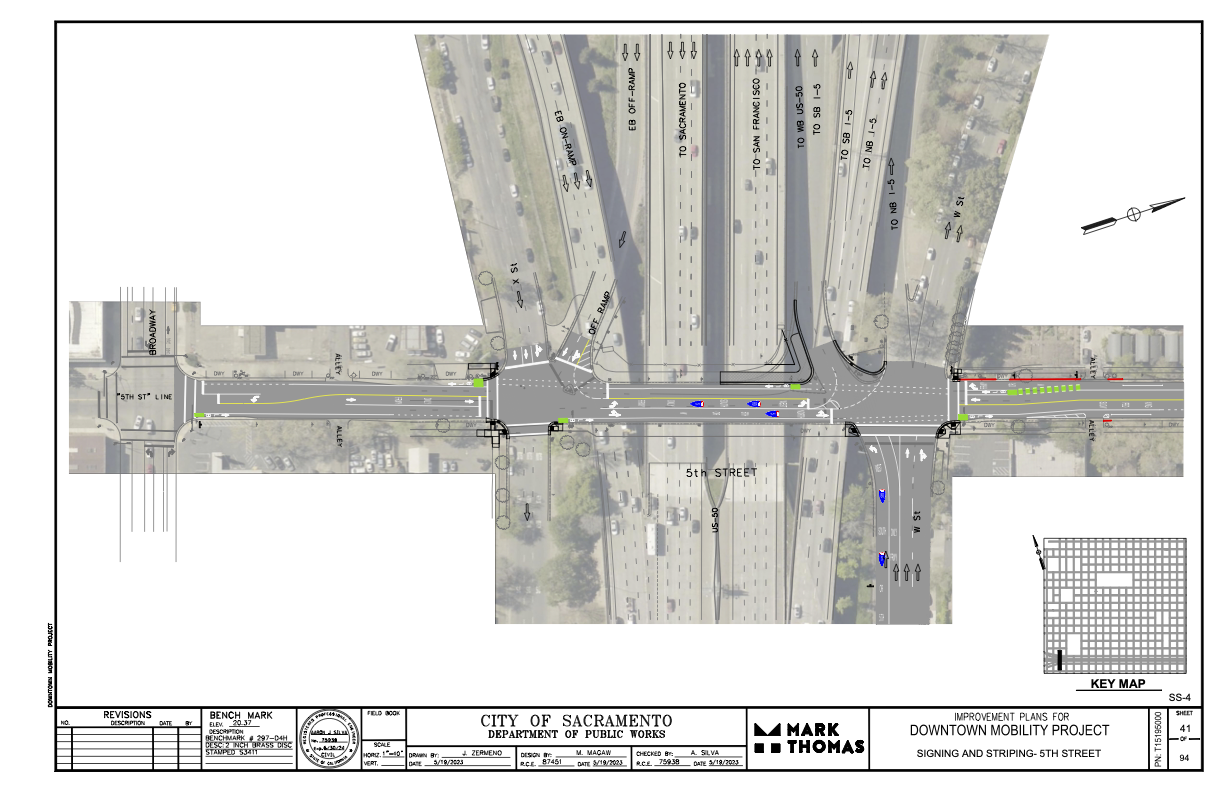
I had earlier expressed concern and lack of information about where the 5th Street one-way to two-way conversion will be handled where 5th Street passes under Hwy 50. (Yes, I know, that this is technically not Hwy 50, but everyone thinks it is, so…)
The following diagram was provided the the city and design firm (pdf). The configuration looks workable, and it probably not any less safe than the current mess. The merging of the two on-ramps into one narrower entrance will probably help to slow traffic entering the freeway, making 5th Street a bit safer. Same with the narrowing of the off-ramp. The curb line will need to be moved in a few locations to accommodate the entire street width with bike lanes, but the curbs here are already quite deteriorated, so that work would be needed in any case. It is not clear from the diagram whether the missing sidewalks in the block between Broadway and X Street will be corrected.
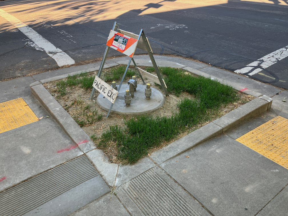
One of the elements of the Central City Mobility Project is the conversion of 5th Street from a one-way, two-lane street, to a two-way, one-lane each direction street. Some work is underway: wiring and signal bases have been installed for the signals necessary for two way traffic at the existing signal locations. Looking at the bases, photo below, I’m guessing that there will be new signal poles and mast arms, not re-use of the existing signals equipment. That seems like a waste of money to me, but the city loves to spend money on new signals, and signal controllers.
I am not sure that many of the current signal locations are even needed. After the conversion, 5th Street will be a lower speed and probably lower volume street. Four-way stops at some major cross streets (such as T Street) might work just fine. Again, the city loves to spend money on signals, and already has unneeded signals at a number of locations (too many traffic signals?).
5th St and T St new signal base
The Central City Mobility Project map shows the 5th Street conversion as extending from Broadway to I Street. The block between Broadway and X Street is already two-way, as are the two blocks between L Street and J Street (the DOCO underpass). It is also two-way north of I Street.
I wonder what, if anything, will be done for the block between X Street and W Street, under the Hwy 50 freeway. This is a very complex block, with a freeway onramp west of 5th Street and a freeway offramp west of 5th Street. The onramp and off-ramp have separate signal phases from X Street and W Street. Traffic westbound onto the ramp, if it makes the green light, is already traveling at freeway speeds, about 65 mph as it crosses 5th Street. Similarly, but not as egregious, the off-ramp traffic, if it makes the green light, is traveling a bit below freeway speeds. I am really not sure how this complex situation can be made safe for bicyclists. Northbound bicyclists only have to deal with drivers running the red light at 5th Street from W Street, but southbound bicyclists would have to deal with multiple turning vehicle movements. In general, the only way to make complex situations like this safe is to have exclusive bicycle phases in which only bicyclists and walkers are moving, no vehicle movement or turns are permitted. But the city is very unlikely to select that safe alternative because it would lengthen the signal cycles and therefore slow motor vehicle traffic to some degree. The city doesn’t want to slow motor vehicle traffic.
The diagram below, from Google Maps, indicates the complexity of this block, but the reality on the ground is even worse.
The City of Sacramento’s Central City Mobility Project is underway, and projected to finish by next May. The map below shows the major components of the project: new parking protected separated bikeways on 19th Street and 21st Street between W Street and I Street, extended parking protected separated bikeways on P Street and Q Street from 15th Street to 21st Street, a separated bikeway (not parking protected?) on I Street from 21st Street to 12th Street, and conversion of 5th Street from a one-way street to two-way from Broadway to I Street (the two-block section from L Street to J Street is already two-way). The project also includes upgrades of corner ramps to ADA compliance along 21St, 19th, P, Q and I streets. I notice that ramp upgrades are also occurring at some locations other than these streets, whether under this project or a separate initiative, I’m not sure.
Central City Mobility Project map
As far as it goes, this project looks to be great. The city is making an effort to create a grid of higher quality bicycle facilities in the central city, of a mile spacing, or less. But a bicycle network is only as good as it’s weakest spot, and this project leaves several weak spots in the grid. The map below highlights some of these, shown in cyan color:
P Street and Q Street parking protected separated bikeways should be extended west to 5th Street, which would include a reduction of lanes on those streets. Stopping the bikeways at 9th and 10th Street reduces access to Sacramento Valley Station, as well as many other destinations in this area, including using the Tower Bridge to access West Sacramento.
9th Street parking protected separated bikeways should be extended from Q Street south to Broadway, to provide access to the higher quality bikeway along Broadway, and points south of Broadway.
I Street separated bikeway should be extended from 12th Street west to 5th Street, created a complete bikeway from 21st Street to Sacramento Valley Station.
J Street parking protected separated bikeway should be extended east from 5th Street to 19th Street, to proved a complete bikeway from 5th Street to 28th Street.
A separated bikeway should be constructed on 28th Street to provide a high quality bike route parallel to the unsafe 29th Street one-way southbound traffic sewer and 30th Street one-way northbound traffic sewer.
Regular bike lanes, at a minimum, should be installed on 13th Street between P Street and Capitol Park. 13th Street is one of the most heavily bicycled north-south routes in the entire central city, but this two block gap makes that trip less safe.
It is also possible that the P Street and Q Street bikeways should be extended east at least to 28th Street, or beyond, but I haven’t looked closely at that yet.
Central City Mobility Project map with recommended additionsRead More »
H Street is commonly used by bicyclists leaving Sacramento Valley Station, and others as well. It has decent bicycle facilities except for some gaps.
H Street has a bike lane on the south side from 5th Street to 16th St, except one block, 7th Street to 8th Street. There is absolutely no reason for this gap. This is the section between the Sacramento County Administration Building on the south and a decked parking garage on the north. The parking seems to be there for the convenience of people working in the building, as there does not seem to be turnover of the parking spots. There is ample parking in the garage. This parking should be removed and a bike lane painted IMMEDIATELY. No excuses. A common quote in the bicyclist community is “sharrows are bullshit”, and this is the case here, where the city has preferenced motor vehicle drivers over bicyclist safety.
H St parking and sharrows from 7th St to 8th St
There is a bike lane on the north side between 7th Street and 13th Street. Bike lanes on the left side of one-way streets are much less used than right side bike lanes, but are useful.