One of the many reasons that I travel is to see transportation facilities in different places, ways in which cities have made active transportation and transit better, or worse. I’m in Philadelphia at the moment, and one of the features that has been implemented is…
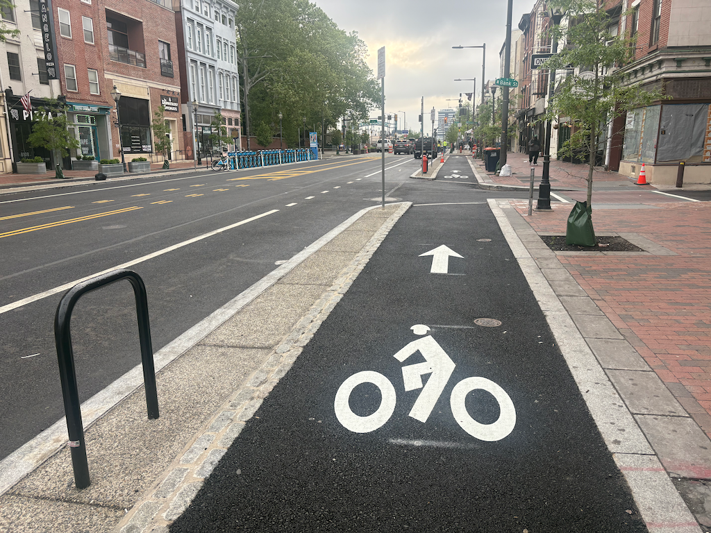
sidewalk-level bikeway on Market St in Philadelphia
These sidewalk-level separated/protected bikeways are on several blocks of Market Street, the main east-west street in Philadelphia. These are new, and were under construction during my last visit a year ago. NACTO calls these Raised Protected Bike Lanes, with designs on the Separating Protected Bike Lanes page (scroll down for this design section).
These bikeways are visually distinctive from the adjacent sidewalk, composed of different materials and colors, red brick for the sidewalk (many sidewalks in Philadelphia are brick), grey granite for the separation, and black asphalt for the bikeway. NACTO recommends a tactile warning delineator (TWD) between the sidewalk and bikeway. The granite separator and change of texture may or may not meet this criteria for visually impaired people. Though
Philadelphia downtown has a significant bicyclist mode share, but it mostly seems to be on the north-south arterials and collectors, not on east-west streets. But this may be an artifact of the time of day I observed. It has a wide variety of bike facilities: traditional bike lanes, vertical delineator ‘separated’ bikeways, two-way separated bikeways (cycle tracks), parking protected bikeways, bikeways along transit islands. I don’t know the criteria, but I suspect that available roadway width is a determinant.
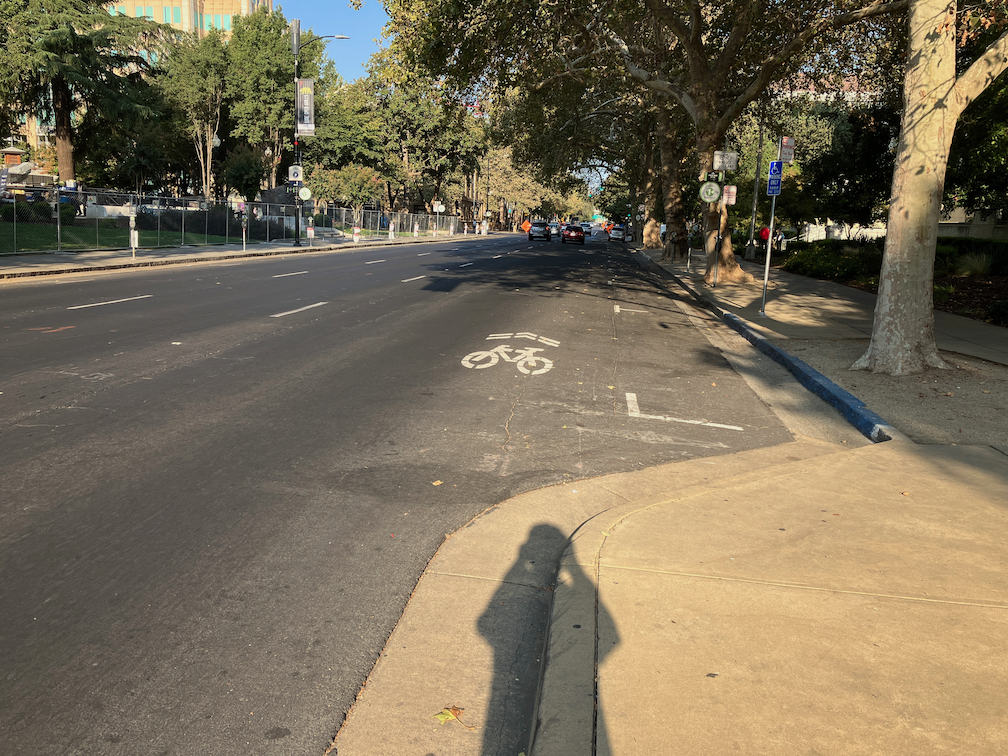
Sacramento is proposing a sidewalk-level bikeway (2-way cycle track) on H Street between 9th Street and 10th Street, at City Hall. I believe the design is for paint on the existing sidewalk, not reconstruction of that section. It will be interesting to see if this design works.
Prior posts on this project, and previous permutations, are available at category: StocktonBlvd.
The City of Sacramento (and partners SacRT and Sacramento County are hosting a public workshop on Thursday, April 15, on the Stockton Blvd Safety and Transit Enhancement Project (STEP). The workshop will start 5:30 PM at the Oak Park Community Center, 3425 Martin Luther King Junior Boulevard, Sacramento, CA 95817. Registration is available (Eventbrite) but not required.
There will probably be a slide presentation, and display boards showing in some detail aspects of the project. These workshops offer the public sticky notes that can be placed on the display boards, and comment cards. If you’d like to see these ahead of time to ponder, or to visit specific sites, tough luck. The city doesn’t do that.
Though the project is about the entire SacRT Route 51, the highest ridership of the system and one of only a few high-frequency (15 minute) routes, the roadway changes would almost entirely be on Stockton Blvd.
The project has three main aspects:
Create a transit priority street for Stockton Blvd between Florin Road and Broadway, or perhaps T Street. This will be a bus rapid transit (BRT)-light facility, with dedicated bus lanes (red) in part, and improved bus stops.
Add bike lanes, usually buffered but not separated, to Stockton Blvd.
Add and improve pedestrian crossings of Stockton Blvd, which current has few safe crossings.
Two bus route alignments are being considered, the existing Route 51, and an alternative 2 that would continue on Stockton north of Broadway to T Street, thereby serving Aggie Square/UC Davis Medical Center.
What the project neglects is:
Wider sidewalks. These should be a minimum of 8 feet. Existing sidewalks are often 4 to 6 feet, and are curb-attached, immediately adjacent to motor vehicle danger.
Trees, and the wide sidewalk buffers (8 feet minimum) necessary to host healthy trees without root heaves that buckle sidewalks over time.
Though the project benefits include “More inviting public spaces with improved lighting and landscaping”, there are so far no details on what that means. Lighting is often ‘motor vehicle scale’ on tall standards and illuminating the roadway, not ‘pedestrian scale’ and illuminating the sidewalk for safety and aesthetics. Though there are a few locations in Sacramento with pedestrian scale lighting, these were installed by developers long ago when people walking were considered more important than people driving.
What are your thoughts? Concerns? Ideas? If you aren’t able to make the workshop, there is also a survey. The survey asks for your use and interest pattern, but is not intended to gather detailed feedback.
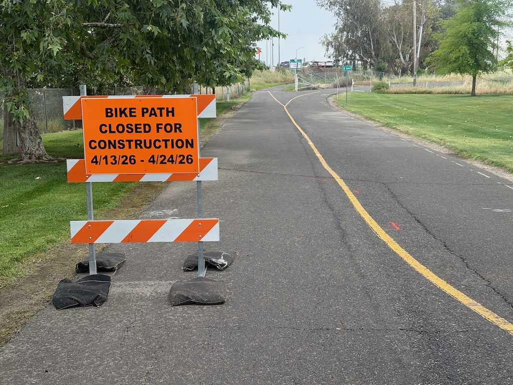
The Yolo causeway bike path will close for a week and a half starting Monday April 13 (tomorrow). The part that will close is actually very short, from the path rest area in West Sacramento to the beginning of the causeway bridge, but since there is no alternative route, the entire distance from West Sac to Davis is closed.
Presumably the closure will be to improve or replace the section of very deteriorated path as it ramps up to bridge level. This is a good thing. The problem is that most users of the path would have no way of knowing beforehand. It is not signed where the path departs West Capitol Avenue westbound, nor is it signed where the path departs County Road 32A eastbound.
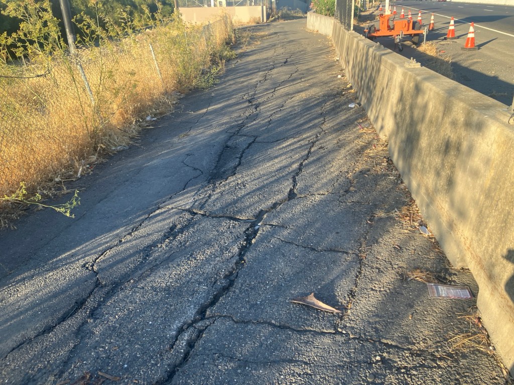
Yolo causeway bike path deteriorated pavement
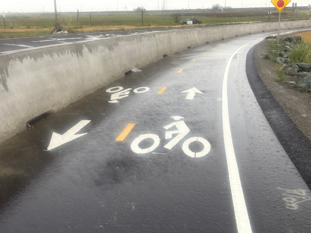
The west end has been improved. Rather than turning on to the levee, it follows the off-ramp from the freeway, protected from motor vehicles by concrete barrier ( sometimes called K-rail or Jersey barrier, but it isn’t clear if this is the term for permanent barriers). However, the junction with County Road 32A is not complete, and may have safety issues.
Yolo causeway bike path approaching County Road 32A
The drainage problems on the causeway portion of the path have not been solved, so there will be extensive puddles after rain, as yesterday. The path continues to collect debris from the highway, car and truck parts and trash. Caltrans passed on the opportunity to provide path lighting, even though electric was embedded in the new barrier. And of course noise from the highway is oppressive. As with all Caltrans projects, two steps forward and one step back.
Re-upping the Elvas Ave and Hornet Tunnel post from earlier this year. It has been reported to me by a number of bicyclists, and I have experienced it myself, that this section of Elvas between the Hornet Tunnel and the signal at 62nd Street has become significantly more hazardous due to the motor vehicle traffic generated by The Line (a collection of various food vendors, opened 2022) and Garden at the Line (an outdoor eating and drinking area adjacent to The Line, opened this December). There is a lot more come and go parking on Elvas, and a lot more motor vehicle traffic in and out of the parking lots. Most bicyclists ride on the sidewalk to avoid the fast-moving traffic, otherwise the crash rate would be higher. The M Street to Elvas Avenue to Hornet Tunnel route is probably the busiest in the city.
In addition to the previous post (reblog below) about the hazards for bicyclists, this area is now hazardous for walkers along and crossing Elvas.
I was there last night for the SABA social gathering, and the place was packed. People were parking along the west side of Elvas as well as on 63rd Avenue and 64th Avenue, and then trying to cross Elvas to Garden at the Line. It was nearly impossible to cross, as there are no marked crosswalks over Elvas at either street, drivers are going fast, and Elvas is not well lit. The speed limit in this section is 40 mph, which almost guarantees that walkers hit by cars will die. Sidewalks on both sides of Elvas are in poor condition, and rolled curbs are common, which are less safe for people walking than vertical curbs. There are no sidewalk buffers. While this section of Elvas is not one of the top 5 or top 10 Vision Zero corridors, it will quickly become so. In the last five years, there have been two injury crashes on this stretch, one bicyclist and one walker, both in the vicinity of Hornet Tunnel.
The city has no plans to improve safety for bicyclists or walkers on this stretch of Elvas.
The white line stripes that were added to the two blocks of P Street protected bikeway, 19th Street to 17th Street, are an attempt to keep leaf piles and trash cans out of the bikeway. I noted the added white stripes in Central City Mobility update #27, but wasn’t sure why they were added. The wording was added later. I have not yet observed this location on either a trash pickup day, or now that there are a lot more leaf piles. I have not seen the striping and marking on other blocks of the new bikeways, so this may be a pilot to see if it works. The practice of putting leaf piles in the regular Class 2 bike lanes in common, and the city has made no effort to reduce this practice.
On Wednesday afternoon, the sign below was on 21st Street approaching I Street. The sign was not there on Tuesday morning. If a bicycle signal was intended at this intersection in the design, why was it not signed earlier? Why wasn’t the signal already installed, since there was signal communications infrastructure installed at this intersection several weeks ago? Or was this a design oversight that the city decided to fix after being called out on it? And when is ‘coming soon’?
21st St at I St, sign for future bicycle signal
I observed bicyclist behavior at this location for a while on Tuesday. Every single bicyclist who was headed north on 21st Street crossed against the red light, so as to not be hit by left turning drivers who generally do not yield to anyone in the crosswalk, and then onto the sidewalk on the west side of the street, continuing through the area at Old Soul Weatherstone which is congested with tables and walkers. So the city has trained bicyclist to ride on the sidewalk. Those who have been so trained will be likely to continue sidewalk riding even after installation of the signal. Ouch!
Useless Turn Wedges
I have ridden 21st Street a number of times, to see how the project is progressing and to see how drivers are responding to the new layout. Most drivers are parking correctly in the parking that provides parking-protection for the bikeway, but a few continue to park against the curb. I’ve reported these to 311 for parking enforcement, but of course as always, parking enforcement reports that the vehicle is no longer there, whether it is or not.
Several times in a row drivers have turned across my path at high speed, left from 21st Street to L Street, over the green paint and the white turn wedge paint. At the times of day I was there, there were few to no parked cars, so I was clearly visible to the drivers, not in any way hidden. In both cases I had to slam on my brakes to avoid being hit by the drivers. They did not slow. The turn wedge diagram provided on the Central City Mobility Project page, shown below, clearly shows bumps and posts (vertical delineators) in the wedge. Without more detail, I can’t say whether these will actually affect driver behavior, but in general only hard curbs or real bollards (steel or concrete) actually affect driver behavior. In the meanwhile, drivers are being trained to turn across bicyclists, with impunity, and will not likely change their behavior when and if something is installed in the turn wedges.
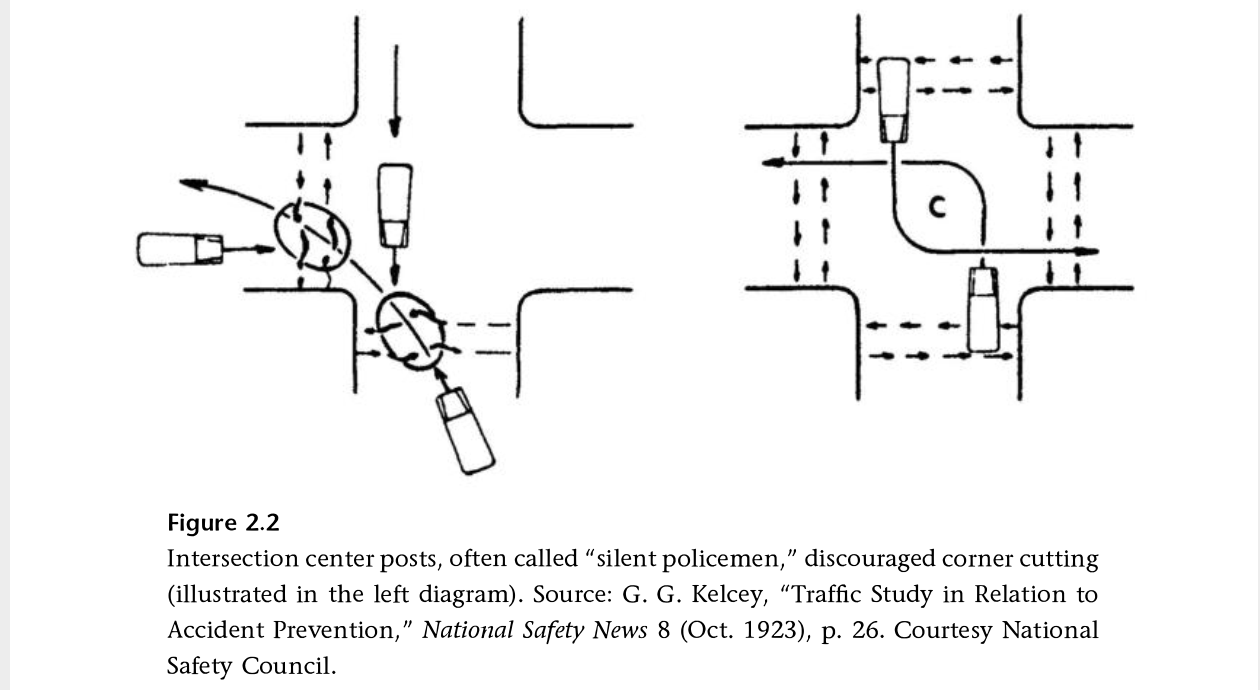
I have been reading Fighting Traffic by Peter Norton, and in Chapter 2 he introduces the concept of the outside left turn, which worked to prevent drivers from cutting the corner on left turns, and was later enforced with ‘silent policemen’, hard structures that provided serious consequences for drivers who insisted on cutting corners. Later, when motor vehicles were given dominance on the roadway, these were removed. It is time to bring these back!
Other
Striping and green paint is very nearly complete on 21st Street. 19th Street has been repaved and preliminary marking installed (the dashed white lines). P Street was just stripped for new pavement (I’m not sure what this process is called, removing 2 to 3 inches of old pavement so that new pavement can be laid), and is being repaved today (Thursday). Q Street has been patched but not stripped. I’m not noticing any active work on I Street, 5th Street, 9th Street, or 10th Street, though I Street has had ‘no parking’ signs up for some while.
The repaving is being done to the full width of the roadway, including the parking lane. This is a waste of materials and money. The parking lane does not need to be repaved, except in a few circumstances where it has been damaged. Nor does it need to be paved to the same standards as the general purpose travel lanes, which receive far more traffic and wear and tear. But the city loves pavement, and loves to add on unnecessary work to projects, ensuring that less is left for actual improvements to the street that would help walkers and bicyclists.
H Street is commonly used by bicyclists leaving Sacramento Valley Station, and others as well. It has decent bicycle facilities except for some gaps.
H Street has a bike lane on the south side from 5th Street to 16th St, except one block, 7th Street to 8th Street. There is absolutely no reason for this gap. This is the section between the Sacramento County Administration Building on the south and a decked parking garage on the north. The parking seems to be there for the convenience of people working in the building, as there does not seem to be turnover of the parking spots. There is ample parking in the garage. This parking should be removed and a bike lane painted IMMEDIATELY. No excuses. A common quote in the bicyclist community is “sharrows are bullshit”, and this is the case here, where the city has preferenced motor vehicle drivers over bicyclist safety.
H St parking and sharrows from 7th St to 8th St
There is a bike lane on the north side between 7th Street and 13th Street. Bike lanes on the left side of one-way streets are much less used than right side bike lanes, but are useful.
Next sharrows location to address is I Street between 10th Street and 9th Street. The bike lane present to the east disappears in this block, with Cesar Chavez Plaza on the south and Old City Hall on the north, before picking up again west of 9th Street. Not having my tape measure out (and I’d have to measure late night when there is no traffic), it isn’t clear why this one block does not have a bike lane. It may be that the curb extension is too wide, or it may be that the general purpose (car) lanes are not configured correctly. If lanes, then it is an easy problem to fix, just re-stripe the lanes and add a bike lane. If the curb extension, then that would require a bit of infrastructure work. I fully support curb extensions, nearly all intersections should have them, but in some places the city has installed them incorrectly and caused issues for bicycle facilities. This is not, as many places are, a case for removing parking, but for designing the street correctly. Of course ultimately there should be no three-lane one-way traffic sewers in the city, and right of way should be reallocated to a separated (protected) bikeway and wider sidewalks.
I St westbound at 10th St, Sacramento
Caveat: I post about issues in the central city because I live here, and see the problems every time I am out walking or bicycling. However, I strongly believe that the city should be focused on solving issues in lower income, disinvested neighborhoods, of which there are ample throughout the city. The central city has received more than its share of bike facilities.
City of Sacramento staff (Drew Hart) presented to the Sacramento Active Transportation Commission last Thursday on the Freeport Boulevard Emerging Design Concepts. The presentation slides are here. The city’s Freeport webpage has a lot of background material. A link to the virtual open house on April 28 (tomorrow!) is available. This project and the Northgate project are being supported by the same consultant, so you will notice similarities in the process and graphics.
The northern section, between Sutterville Road to the east and Sutterville Road to the west, should look exactly like the traffic-calmed, complete street to the north. This project on Freeport was successful. There is no reason for five lanes in this section. One lane northbound, one lane southbound, and one left turn lane southbound is all it needs. If traffic backs up at the Freeport and Sutterville Road to the east intersection, then shorten the signal cycle.
The emerging design document skips over the issue of whether four general purpose lanes are even needed. A concept should be presented that reduces general purpose lanes to two, and reallocates roadway width to other modes.
Dedicated right hand turn lanes should be removed everywhere. Dedicated left hand turn lanes should be provided only where traffic studies have shown a clear need, and should never reduce the roadway width for other uses.
Green lanes are shown behind protection for separated bikeways. Since the protection does or should prevent vehicle incursion, the paint is not needed.
Dedicated transit lanes should be considered. Though SacRT has not identified this as a high frequency route in the High Capacity Bus Service Study (Route 62 is 30-minute frequency), reconstruction of the roadway must consider the possibility of dedicated transit lanes and transit supporting infrastructure. Appendix A, available on the project webpage, provides a lot of detail about existing transit stops, which are mostly quite poor.
Some businesses along Freeport have multiple driveways, more than are justified by the amount of vehicle traffic access. Closure and narrowing of driveways should be considered. Since almost every business has parking fronting the street, no on-street parking is needed anywhere. This is poor urban design, but it is the nature of the corridor and could not be corrected without wholesale reconstruction of the corridor.
While separated bikeways are often a good solution, the frequency of driveways might make for poor quality infrastructure. Unless driveways can be closed or reconfigured, separated bikeways may not be the best solution.
Posted speed AND design speed should be considered for reduction. Posted speed is 30 mph from Sutterville Rd (to the east) to Arica Way, 35 mph from Arica Way to Fruitridge Rd, and 40 mph from Fruitridge Rd to Blair Ave. The section from Sutterville Rd (to the east) to Fruitridge Rd should be posted and designed for 25 mph, in recognition of the density of businesses and driveways. The section from Fruitridge to Blair Ave should be posted and designed for 30 mph, as it has a lower density of businesses and driveways, and is adjacent to the airport for a significant distance.
Prioritization of the modes for Sutterville (to the east) and Fruitridge Rd should be:
walking
bicycling
transit
motor vehicle
Prioritization of the modes for Fruitridge Rd to Blair Ave should be:
bicycling
transit
walking
motor vehicle
Crash/collision map of the Northgate Blvd corridor for pedestrians (walkers) and bicyclists. Data is from SWITRS for the years 2015-2019. (pdf)
Another classic mistake by the City of Sacramento. Re-striping was just done on several blocks of N Street. Eastbound on N Street 22nd Street, this is what it looks like.
N St eastbound at 22nd St
Take a close look. Extend the dashed line forward, and you’ll see the taper, from a regular bike lane adjacent to a parking lane, to just a bike lane. Look even closer. See where the no parking sign is? A vehicle can park that close to the intersection, completely blocking the bike lane, and in fact blocking part of the general purpose lane. Yesterday, when I rode by, but neglected to take a photo, there was a large pedestrian-killer pickup truck parked right up to the no parking sign, and it was actually covering up three of the dash marks. Riding a bicycle in the bike lane and expecting it to continue? In Sacramento, that is not a reasonable expectation.
I would hope that the striping crew, whether city or contractor (not sure which this was) would notice the problem and stop painting until this was clarified. But it is not really the responsibility of the stripers. This design was signed off on by a ‘professional’ engineer employed by the city. This is the quality of people the city employs.
Westbound on N Street, it is not as bad since the no parking sign is further from the intersection. See below.
N St westbound at 22nd St
It is still a poor design, but nowhere near as dangerous.
As I’ve said before (traffic calming in the central city), these median islands, when placed in this way, as a widening of the center line only at intersections, are a hazard to bicyclists, though they do provide some safety for pedestrians. The best traffic calming measure, and the one that should be used by the city, is traffic diverters.