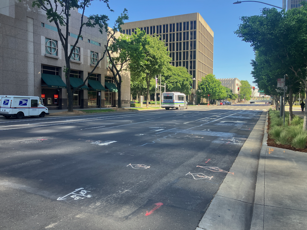
I noticed over a week ago that all striping has been removed from 5th Street, including crosswalks, so had presumed that the conversion from one-way to two-way was immanent. Nope. Nothing has happened since then. I guess the city thinks it is OK to remove striping from a street and then do nothing. In a sense, it might be OK, because drivers, without striping to guide them, will be uncertain, and slow down. Maybe.
This is Central City Mobility Project update #33. Note that 5th Street has not yet been converted from one-way to two-way.
When looking at 5th Street, part of the Central City Mobility Project to convert this from a one-way street to a two-way street, I was focused on the looking at the new signals and the mast arms. I failed to notice all the new beg buttons that have been installed. These are the ‘wave at’ variety. Installations are at Q Street, P Street, N Street and Capitol Mall. At Q, P, and N Streets, there are 8 new buttons per intersection. At Capitol Mall there are six, all on the east side of the intersection, because there is a pedestrian crossing prohibition on the west side. I don’t have documentation of what was here before these were installed, but I’m pretty sure that these intersections were on auto-recall, meaning that the button did not need to be pressed, or waved at. I have to admit I have been fooled again by City of Sacramento Public Works. I had been assuming that either things would remain the same, or things would get better. They have proved me wrong by making things worse.
5th St & Q St SE new wave beg button
There are beg button posts installed at R Street as well, but since this crossing of 5th St has not been activated, I don’t know how the beg buttons will be labeled.
I have written before about excess signals in the central city: too many traffic signals?. The fact that these exist is bad enough, but as part of the 5th Street conversion project, one-way to two-way, the city is replacing unnecessary old signals with very expensive and unnecessary new signals.
At 5th Street and S Street, a new signal is being installed. S Street is a low volume street that never needed and never should have had a traffic signal. A four-way stop sign, maybe, or maybe only stop signs for S Street. A fully signalized intersection, no way. There is nothing wrong with the existing signal for northbound traffic. Of course, a new signal is needed for southbound traffic. But the city is replacing northbound. Why?
Why is the city putting in a new signal here? Because there was one here before. If this intersection were studied for whether it needed a signal, the answer would be no. A warrant is a study indicating a need for a signal, as is simply explained at http://www.apsguide.org/chapter3_mutcd.cfm (this is much easier to read than the MUTCD). The 5th Street & S Street intersection does not meet any of these criteria. So, the city is putting in a new signal because they want to, not because it is necessary.
new and unnecessary signal at 5th St & S St
The current cost of a fully signalized intersection is $200K to $500K. Half a mil per. Your tax money. For intersections like 5th Street and P Street, a signal probably is necessary, particularly since the P Street and Q Street traffic sewers encourage high speeds.
It is likely that the signal at T Street is similarly unnecessary, however, T Street is busier than S Street, so might be justified by traffic volume. I’d like to see the city do a new traffic warrant study on this intersection. The city always uses warrants as an excuse for something it does not want to do, but seems to ignore these for things it wants to do. A typical traffic engineering misuse of MUTCD guidance.
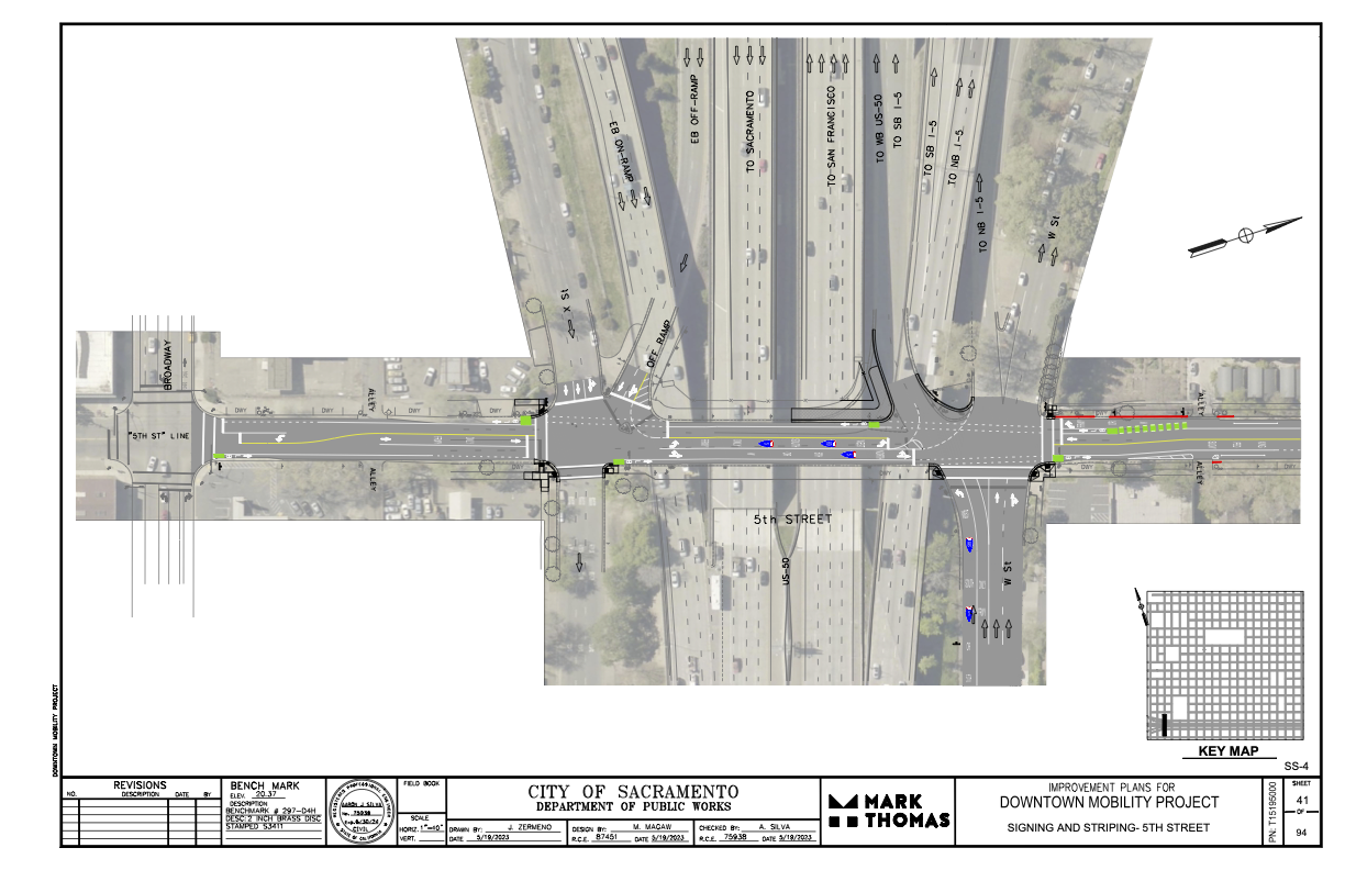
I had earlier expressed concern and lack of information about where the 5th Street one-way to two-way conversion will be handled where 5th Street passes under Hwy 50. (Yes, I know, that this is technically not Hwy 50, but everyone thinks it is, so…)
The following diagram was provided the the city and design firm (pdf). The configuration looks workable, and it probably not any less safe than the current mess. The merging of the two on-ramps into one narrower entrance will probably help to slow traffic entering the freeway, making 5th Street a bit safer. Same with the narrowing of the off-ramp. The curb line will need to be moved in a few locations to accommodate the entire street width with bike lanes, but the curbs here are already quite deteriorated, so that work would be needed in any case. It is not clear from the diagram whether the missing sidewalks in the block between Broadway and X Street will be corrected.
Note: Info on 9th Street and 10th Street added below.
For other posts on the City of Sacramento Central City Mobility Projects, see category: Central City Mobility Project. I’m not sure how interested readers are in my minor updates, but I think it is fascinating to see how the city is repurposing street right-of-way, solving problems (or not), and what is being prioritized in the overall project. I’ve not seen any signs of construction on P and Q streets, other than the ADA ramp work that has been going on for several weeks.
Turn Wedge
The project page has a diagram that I had not exactly seen anywhere before, the corner wedge, below.
Central City Mobility Project diagram turn wedge
I saw a location marked for a turn wedge yesterday, at 21st St and O Street, southwest corner, below. This is a little bit like a corner of a protected intersection.
Sac_21st-St-O-St-SW_turn-wedge
5th Street Two-Way Conversion
I looked at the length of 5th Street, from Broadway to I Street. I still have no insight into what will be done under Hwy 50 where there is a one-way block that is closely tied to the freeway onramps. I have requested clarification from the city but they have not answered yet. I’ll update when I hear.
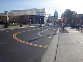
Signal bases have been installed for new signals from W Street to N Street, but not north of there. Active work was going on at N Street. At R Street, it looks like the existing pedestrian flashing light will be duplicated for the other direction. This is not a full signal, nor a user-activated signal, but always on.
Between Broadway and X Street, 5th Street is two-way, four lanes, with sharrows marked (and very faded) in the outside lane. Sharrows are no longer considered valid bikeway markings, so presumably there will be marked bike lanes here. There are three very-wide blocks for 5th Street, from N Street to L Street, and from J Street to I Street. From N to L, there are two through lanes and one or two left-turn lanes, plus parking and bike lanes. From J to I, there are two through lanes and two left-turn lanes, plus parking left and right and a bike lane on the right.
On the west side of the intersection of 5th Street and I Street, there is a crossing prohibition. I hope that the city removes this prohibition as part of the project. In most cases, freeways onramps and off-ramps being an exception, crossing prohibitions are an attempt by the transportation agency to prioritize motor vehicle volume and speed over all other considerations. They are morally wrong, and should be legally wrong.
Sac_5th-St-N-St_extra-wide
I Street Separated Bikeway (and lane reduction)
Some work has started on the I Street separated bikeway, which will run from 21st Street to 12th Street (see the importance of I Street for why it should continue west). Most corner ramps were already ADA compliant, but the few that were not have either been upgraded or are in progress. Fabric covers have been set up over drain inlets, and temporary no parking signs line the street, so I assume repaving will occur soon. I don’t see any indication of whether the separated bikeway will be on the right side or left side of the street. I Street does not have SacRT fixed route bus service, which engenders left side bikeways, though there is some commuter bus service on the street.
The project map indicates that I Street will be “lane reduction and separated bikeway”, not parking protected separated bikeway, so this will be a different configuration than 19th Street and 21st Street.
I will be interested to see if the city will address the lack of sidewalk on the south side of I Street between 16th and 15th, where the city installed a loading dock for Memorial Auditorium in place of the former sidewalk. I strongly believe that removal of sidewalks, as was done here, are criminal (Sac permanently closes sidewalk).
19th Street Repaving
It looks at though 19th Street is not going to be completely repaved in the way 21st Street was, rather, it is getting spot repaving. I don’t know whether there will be an overlay so that the new marking are on a fresh blank canvas.
9th & 10th Street Parking Protected Separated Bikeway
The 10th street parking protected separated bikeway will be extended from Broadway to Q Street. The block of Q Street to P Street has a buffered bike lane, outboard of parking in the south half, and without parking in the north half, and since that block has recently been changed, it will likely stay that way. There is a buffered bike lane from Q Street to L Street, and then a parking protected separated bikeway of variable quality from L Street to I Street. There is no bus service on 10th Street, so the right side configuration will probably be maintained throughout.
10th Street is relatively wide under Hwy 50, so no special treatment here will be needed.
On 10th Street there are ADA ramp upgrades at several locations, and several more haven’t started yet. The street has a lower rate of ADA compliance than many central city streets. There is no indication of roadwork yet.
The 9th Street parking protected separated bikeway is being extended south from L Street to Q Street. There is no indication of any sort of work here yet. Most corners already have compliant ADA ramps. There is construction on the east side of 9th (right side southbound) between L Street and Capitol Mall, and on the west side (right side southbound) between N Street and O Street, and between P Street and Q Street. All of these construction projects will probably be going on for quite some time, and this may be the last street to be modified. SacRT Bus Route 51 runs on 9th Street south of Q Street to Broadway, which is outside this project scope, but presumably argues for keeping the left side bikeway configuration throughout.
One of the elements of the Central City Mobility Project is the conversion of 5th Street from a one-way, two-lane street, to a two-way, one-lane each direction street. Some work is underway: wiring and signal bases have been installed for the signals necessary for two way traffic at the existing signal locations. Looking at the bases, photo below, I’m guessing that there will be new signal poles and mast arms, not re-use of the existing signals equipment. That seems like a waste of money to me, but the city loves to spend money on new signals, and signal controllers.
I am not sure that many of the current signal locations are even needed. After the conversion, 5th Street will be a lower speed and probably lower volume street. Four-way stops at some major cross streets (such as T Street) might work just fine. Again, the city loves to spend money on signals, and already has unneeded signals at a number of locations (too many traffic signals?).
5th St and T St new signal base
The Central City Mobility Project map shows the 5th Street conversion as extending from Broadway to I Street. The block between Broadway and X Street is already two-way, as are the two blocks between L Street and J Street (the DOCO underpass). It is also two-way north of I Street.
I wonder what, if anything, will be done for the block between X Street and W Street, under the Hwy 50 freeway. This is a very complex block, with a freeway onramp west of 5th Street and a freeway offramp west of 5th Street. The onramp and off-ramp have separate signal phases from X Street and W Street. Traffic westbound onto the ramp, if it makes the green light, is already traveling at freeway speeds, about 65 mph as it crosses 5th Street. Similarly, but not as egregious, the off-ramp traffic, if it makes the green light, is traveling a bit below freeway speeds. I am really not sure how this complex situation can be made safe for bicyclists. Northbound bicyclists only have to deal with drivers running the red light at 5th Street from W Street, but southbound bicyclists would have to deal with multiple turning vehicle movements. In general, the only way to make complex situations like this safe is to have exclusive bicycle phases in which only bicyclists and walkers are moving, no vehicle movement or turns are permitted. But the city is very unlikely to select that safe alternative because it would lengthen the signal cycles and therefore slow motor vehicle traffic to some degree. The city doesn’t want to slow motor vehicle traffic.
The diagram below, from Google Maps, indicates the complexity of this block, but the reality on the ground is even worse.
With this post, I’ve added a new category to my blog: re-gridding Sacramento. I’ll have more to say about that category, and many more posts, in the near future.
Sac Valley Station exit, forced right
5th St to I St, forced right turn
Let’s say one was driving and wanted to leave the Sacramento Valley Station (Amtrak and Capitol Corridor) to head southbound or eastbound. Tough luck. The exit at the east end of the parking lot forces you to turn right, to the south, onto 5th Street. I often see people turning across the double yellow line to go northbound on 5th Street, and to be honest, I don’t blame them, because this is the logical though illegal way to go south or east.
Thank you, Elle, for reminding me in your “transportation ‘planning’ downtown” that I wanted to write about I Street. Note: If you are looking at Google Maps, it does not show the current lane configuration on I Street since the repaving and re-striping project of last fall, nor the realignment of tracks and work on extending 5th and 6th streets over the tracks.
I Street from the 4th Street crosswalk; I have the walk signal but this is still scary
I Street in Sacramento approaching the train station is a mess. Starting with the confusing floating bike lane between 7th and 6th streets (subject of a future post), the street becomes worse and worse: five lanes wide, high speed, and completely unfriendly to bicyclists and pedestrians. For pedestrians, the crossing on the east side of the I/5th intersection is uncomfortable because westbound traffic is already moving at high speed and often runs the red light, and right turning cars from I to 5th often do not yield to pedestrians in the crosswalk. The west side is so unsafe due to traffic turning left off 5th Street, it is signed against pedestrian crossing, even though this is a logical walking route from downtown to the train station. A crosswalk has been added on the east side of the I/4th intersection, but it has the same challenges that drivers are moving too fast and often run the run light. When I used this new crosswalk, I was very concerned, and I have a much higher tolerance for danger than most people do.
The right-most two travel lanes lead to the high-speed northbound I-5 freeway onramp, so drivers passing 6th Street are already accelerating to freeway speeds, many times going 55 mph as they cross through the I/5th intersection. The next two lanes lead to a medium speed onramp to the I Street bridge over the Sacramento river, and to the southbound I-5 onramp. For pedestrians, the only way to go westbound towards Old Sacramento is to go through the parking lot for the train station and under the onramps along an ugly, dark, poorly marked pedestrian way.