- Sacramento just issued 1,744 late-night parking tickets. Here’s where … (SacBee 2016-12-17); wah, wah-wah-wah, wah
- Could Sacramento become the nation’s hub for testing of self-driving cars? (SacBee 2016-12-15); Business, civic leaders push for driverless-car testing in Sacramento (Sacramento Business Journal 2016-12-15)
- Sacramento eyes redesign of staid Capitol Mall (SacBee 2016-12-13)
- How fast should you drive in the carpool lane? CHP weighs in (SacBee 2016-12-12)
…or friendly to people…
“You can have a city that is friendly to cars, or friendly to people, but you cannot have both.” —Enrique Penalosa
Slow Transportation (part 4)
4. Tagline and Logo
I’m in search of a tag line for Slow Transportation. Something on the order of:
“Eat food. Not too much. Mostly plants.” ― Michael Pollan, In Defense of Food: An Eater’s Manifesto
“Short trips. Not too many. Mostly walking and bicycling.” Well, it’s a start.
 It also needs a logo, like the Slow Food snail. Maybe a tortoise, maybe a rabbit. Despite the fable, a rabbit is not a bad model, capable of speed when necessary, but mostly happy to much the grass and vegetables close to home, going only as far as necessary for the purpose of eating and living.
”Everywhere is walking distance if you have the time.” —Steven Wright
5. Sources for Slow Transportation
My thinking about Slow Transportation has been influenced by a variety of sources, most obviously Slow Food and Slow Money. Though I’d read it before, I skimmed: Tasch, Woody (2011-09-19). Inquiries into the Nature of Slow Money: Investing as if Food, Farms, and Fertility Mattered. Chelsea Green Publishing. Kindle Edition. It helped me frame my thinking about slow versus fast.
Some tidbits from the two websites and books:
- “To be worthy of the name, Homo Sapiens should rid himself of speed before it reduces him to a species in danger of extinction. A firm defense of quiet material pleasure is the only way to oppose the universal folly of Fast Life. May suitable doses of guaranteed sensual pleasure and slow, long-lasting enjoyment preserve us from the contagion of the multitude who mistake frenzy for efficiency.” – Slow Food Manifesto
- “The combination of fast and slow components makes the system resilient, along with the way the differently paced parts affect each other. Fast learns, slow remembers. Fast proposes, slow disposes. Fast is discontinuous, slow is continuous. . . . Fast gets all the attention, slow has all the power. . . .” – Stewart Brand, Clock of the Long Now
- “The public thought nothing of a car,” Ford wrote, “unless it made speed—unless it beat other racing cars. . . . I never thought anything of racing, but the public refused to consider the automobile in any light other than as a fast toy.” – from Inquires into the Nature of Slow Money
- Where we live is separate from where we work. Mobility takes precedence over responsibility. We become a nation of commuters and tourists. – Woody Tasch, Inquires into the Nature of Slow Money
My thinking is also strongly influenced by Strong Towns, which has so well documented the failure of stroads (the ineffective combination of a street and road, which serves neither livability or commerce) and the coming fiscal insolvency of our cities, counties and states, and Streetsblog, always a source of innovative thinking and solutions to the transportation problems that face us.
6. What Do You Think?
If you’ve gotten this far, you have probably found some resonance, found some things you disagree with, wanted clarification, or had ideas of your own.
Please, please comment. Though this has been useful to me to write it, it could be useful to others if you can help me improve it, maybe expand it, maybe simplify it.
The whole series, in one pdf.
Slow Transportation (part 3)
3. What Slow Transportation Isn’t
It isn’t flying in airplanes.
It isn’t driving over 25 mph except on roadways designed for higher speeds that connect places rather than go through places. For example, the highway to the mountains. But not the stroad arterial in your neighborhood, and never a residential street. In fact, 20 mph is a better number (see Twenty is Plenty).
It isn’t driving your kids to school.
When I ask people why they have a car, they most often answer one or more of three things:
- to get to work
- to buy groceries
- to get to the mountains or the beach
There are solutions for each of these. If one choses to live far from work, or work far from home, driving is almost inevitable. But people do change jobs and housing, much more often than they admit, and could make the choice to be closer. Work and car are a classic Catch 22: I work to pay for my car, I have a car to get to work. It need not be this way. One can choose a job/housing situation allows walking, bicycling, or transit.
People’s grocery shopping patterns lean towards two extremes: 1) driving a mile to pick up a quart of milk; or 2) buying so many groceries at a time that they could not possible be carried by walking, bicycling or transit. But there is a middle ground, making more trips to the store and buying quantities that are walkable, bikeable, transit-able. That is what most of the people in the world do, and it is what we can do. Sure, maybe you do need a car every once in a while for a particular item, but most of the time, no. No. No.
I understand getting to the mountains and beach. I travel to the mountains a number of times during the summer for backpacking. I travel to the bay area about once a month for the ocean and the culture. But for neither trip do I use a car (I don’t have one, don’t want one). I use public transportation, and some bicycling, and some walking. If you are going camping, perhaps you do need a vehicle. Rent one, or find a friend with one! You don’t need that large vehicle sitting in your driveway, or driving around town. And, to be honest, you don’t need to be running to the mountains every weekend during ski season or summer, or the beach every weekend during the summer. Slow down, enjoy the place you live a little more. Yes, Sacramento during the summer can be a little hard to take, but the river is close by, or a cool bar with cold beer.
“You can have a city that is friendly to cars, or friendly to people, but you cannot have both.” —Enrique Penalosa
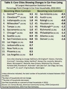
car-free Sacramento
It is amazing what one can find going through drafts of posts that were composed but never posted. Here is one from 2017.
Recently reported research on car-free households in states, major metropolitan areas, and major cities, Car-Free Living in the United States: What the Data Says, indicates that Sacramento metropolitan area increased its car-free households by 0.5%, and the core city (mostly the city of Sacramento) from 9.7% to 10.7%, from 2010 to 2015. Sacramento is #6 in the list at right, not bad
My previous post on car-free workers was Central city car-free workers (2016-04-24), which indicated a central city rate of 5% to 18%, depending on zip code. Since these statistics are workers rather than households, they are related but not directly comparable, since the number of workers per household is often more than one, but sometimes zero.

Slow Transportation (part 2)
2. Slow Transportation As a Solution
I have said for years that the two most important things we do in our lives are what we eat and how we get around (hence the name of this blog, Getting Around Sacramento). The what we eat ground (soil?) is well covered by Slow Food and all the responsible agriculture movements, and ultimately it is likely more important than how we get around, but this after all is a transportation blog, so Slow Transportation is what I’m writing about.
So, what is Slow Transportation?
It considers, for every trip:
- is this trip necessary at all?
- can I combine multiple purposes into one trip?
- what is the shortest distance I can travel for whatever purpose I have?
- am I using the most sustainable mode available?
- what trade-offs are acceptable to me between mode and time?
- how can I address the issue of transportation and food together? (more about this below)
A Slow Transportation approach would:
- reduce the number of trips
- reduce the length of trips
- shift trips from private motor vehicles to walking, bicycling, transit and trains
- almost eliminate the use of airplanes, the most impactful and irresponsible mode
- ensure that all externalities of a particular mode are recognized and either paid for by the user or acknowledged and paid for by society
- make transparent and equalize the subsidies we provide to different modes
Though I’m not sure that these two items are part of Slow Transportation, I’ll add them:
- No New Roads: It means what it says, we have all the roads we need, and more, and don’t need to build a single new one. Anywhere. If we stop greenfield development, we are unlikely to need any, in any case.
- No Net Pavement Increase: We have all the pavement we will ever need, and more. If someone wants to put in more pavement in one place, they can remove pavement in another place, returning that place to some natural state of value.
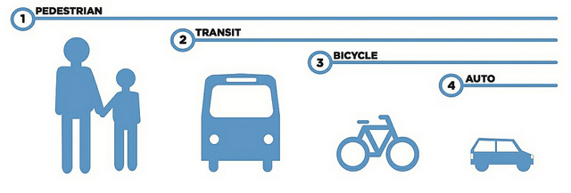
This graphic, from the Chicago Department of Transportation, which I’ve used a number of times before, captures the Slow Transportation even better than words do, though I’ve often wondered if bicycling and transit should be swapped.
“It is a mistake to think that moving fast is the same as actually going somewhere.” —Steve Goodier
…it collects traffic…
“When a road is once built, it is a strange thing how it collects traffic.” —Robert Louis Stevenson
…reduce those speeds…
“If traffic speeds and volumes are high, don’t mitigate with separated bikeways or whatever, try to reduce those speeds and volumes.” —Michael Ronkin
Slow Transportation (part 1)
Recently I was emailing a friend about a Slow Food gathering, and facetiously used the term “slow transportation” for getting there by train rather than flying. But the more I thought about it, the more the term resonated with what I believe in and what I work on. I have not heard, so far as I’m aware, the term used anywhere else, but I think readers of this blog will immediately resonate with it as well. What follows is a first attempt to pin down a working definition of Slow Transportation.
I am going to break this topic up into several posts, but at the end I’ll make it available as a single document in case that is of use to you.
1. What is wrong with our present transportation system?
I am going to keep the list short and succinct because I think most readers of this blog will either already be aware of the issues, and/or will agree that these are the problems. Entire books have been written about each of these issues!
Note: Don’t be depressed by the list of problems below. I promise I won’t leave you there for long.
- transportation accounts for a significant part of greenhouse gas emissions (37% in california, 26% in the US, and 14% worldwide) as is therefore a major driver of climate change
- we have emphasized mobility over access, the ability to get somewhere – anywhere, rather than the ability to get to places we want to go; there is an incredible amount of aimless driving, just for something to do, running a small errand to take up time and fill an empty life; only about 15% of car trips these day have anything to do with commuting to work
- the convenience and low cost of driving has encouraged the separation of functions, where we live, work, recreate and socialize, diminishing the value of each place; though this has started to reverse, we are so far down this road (literally) that it will be hard to bring these back together
- privately owned motor vehicles isolate people rather than bring them together
- traffic violence is inherent in a system based on private motor vehicles; even when people are not killed and injured by the drivers of motor vehicles, they are still intimidated out of the public space, knowing they are at risk there and are being actively discriminated against
- our cities, counties and states are either already insolvent or on their way to insolvency, in part due to the fact that we do not have and cannot ever have enough money to maintain the transportation infrastructure we have already built; though roadways are the worst of this, it is also true to some degree of transit systems, and most certainly our air transport system
- our current wars are in significant part about oil, oil wars; if you don’t think this is so, ponder the fact that the former head of Halliburton, an oil exploration and facilities company, got us into the Iraq war and Halliburton was the prime contractor for that war; it is not just the US with guilt and blood, most of the wars today are at least in part about oil
- we transport our food long distances, disconnecting us from the source, the soil, and the people who grow it; industrial agriculture is both dependent on and a driver (literally) of our unsustainable transportation system; again, this is starting to reverse, but we have lost much of the smaller farmer and small processor capacity of our country, and it will take time to rebuild
- the housing affordability crisis is in part due to a focus on housing costs without considering the transportation costs; the Center for Neighborhood Technology’s H+T calculations indicates that much of the current housing stock is unaffordable because it is located so far from jobs and amenities; it is not really the urban areas (so much in the news) where housing is unaffordable, since transportation costs there are so much lower, but the suburbs and exurbs
- our transportation system takes up too much of our wealth, particularly in the preference for mega-projects like new bridges and freeways, and inattention to small projects that would have greater benefits; there are plenty of things we could be spending transportation money on instead; I dont’ want to minimize the value of transportation investments, but to ask that they have the a similar social return to other things we could spend on
- our transportation system takes up too much of our space, not just with roadways and interchanges, but with parking garages and parking lots and on-street parking; as a result of all this space devoted to one mode of travel, the private vehicle, everything must be further apart, thereby requiring even more driving, in an ever-downward spiral
- our transportation system both encourages and depends upon greenfield development, which leads directly to loss of wildlife habitat and agricultural lands; we already have enough housing stock, but a preference for heavily subsidized greenfield development leads to abandonment and neglect of the sufficient housing stock we already have; greenfield development must stop, now and forever
- there are so many externalities to private car use, costs that are borne by other individuals and society as a whole, that it really amazes me that we even allow private car use
- we have reached peak car; peak does not necessarily mean the greatest number of cars or the greatest vehicle miles traveled, but it means the point of diminishing returns; the costs are now overwhelming the benefits and nothing we do can change that, except to walk away (literally) from dependence on motor vehicles
“The automobile has not merely taken over the street, it has dissolved the living tissue of the city. Its appetite for space is absolutely insatiable; moving and parked, it devours urban land, leaving the buildings as mere islands of habitable space in a sea of dangerous and ugly traffic.” —James Marston Fitch, New York Times, 1 May 1960
News summary 2016-12-11
- Volunteers build bikes for underserved children (SacBee 2016-12-09)
- Sacramento asks developers to open wallets to keep city streets from clogging (SacBee 2016-12-08)
- Are cheaper fares, more airlines headed Sacramento’s way? (SacBee 2016-12-07); I hope not: more flights = more carbon = faster climate change
- How Sacramento can rethink transportation, Chris Morfas (SacBee 2016-12-06)
- Back-Seat Driver: ‘Left-lane loons’ and other Sacramento freeway agitators (SacBee 2016-12-05); left lane loons who drive well over the speed limit and endanger themselves and others are “self-appointed visionaries who have decided what’s good for everyone.” What an idiot you are, Morris Erickson.
