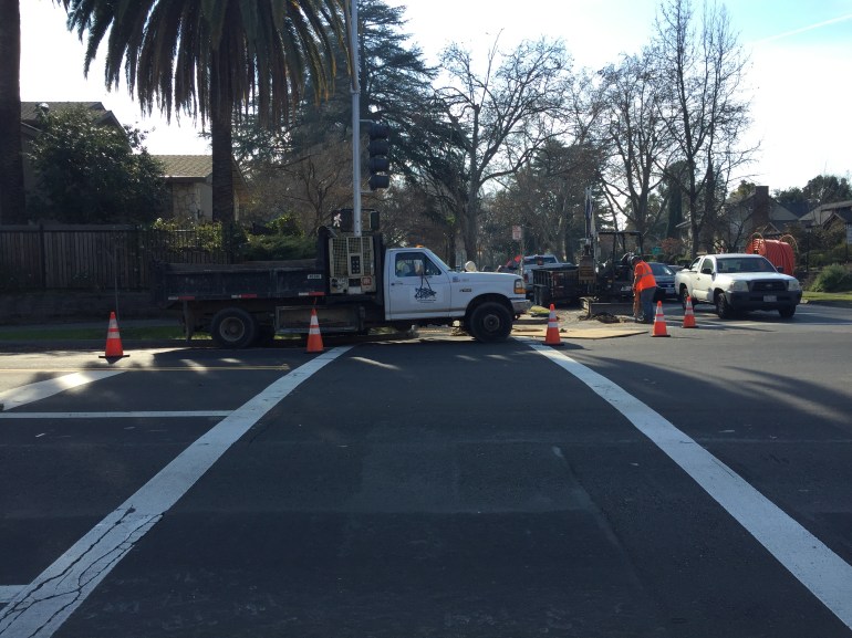
Last week I walked from the Arden Fair Mall area to REI. No, there is no bus that covers that route. There is a sidewalk on the north side of Exposition Blvd, not on the south side. At the I-80 Business onramp to to the freeway south, there is a pedestrian crossing of sorts, as shown in the photo below. There are ADA ramps on both sides of the onramp, but there is no marked crosswalk, there are not signs indicating that it is a pedestrian crossing (at a minimum, there should be a MUTCD W11-2 and W16-7 sign set, shown at bottom. But there is nothing. Drivers are accelerating onto the freeway at this point, not thinking in any way about someone crossing the ramp. Making it worse, the overpass leading to this point is convex, so that sight distances are limited and a driver would not see a pedestrian in time to make a graceful yield or stop. Note in the photo that the ramps are newer than the onramp; they were placed after initial construction, without any attention paid to their actual use. This is typical Caltrans engineering, doing what the law requires without thinking about it at all.

Just barely noticeable in the photo is a sign on the ground just on the other side of the onramp. This sign was knocked over by a vehicle (driver) who either was going to fast or decided at the last moment this was not the ramp wanted, and continued straight, jumping the curb, knocking down the sign, and continuing along the sidewalk before eventually returning to the street.
This location is a pedestrian killer, designed by Caltrans for that purpose.
This interchange needs to be completely redesigned. There should be no free onramps or off-ramps. All traffic should be required to make right-angle turns onto and off the freeway ramps, in order to slow drivers to a safe speed. A safe pedestrian route should be installed to that it is motor vehicles rather than walkers who need to go out of the way. All pedestrian crossings should have marked high-visibility crosswalks, with pedestrian signals that allow an exclusive phase for pedestrians.
I haven’t even mentioned bicyclist facilities here. They are just as bad, just as hazardous at the pedestrian facilities.
Caltrans engineers are directly responsible for any and all crashes involving pedestrians and bicyclists at this interchange. They have designed and promoted something that can and will kill pedestrians and bicyclists.