One of the elements of street design is the width of sidewalk buffers, and how these are presented in design standards. The sidewalk buffer is the area between the curb and the sidewalk. The city calls sidewalk buffers ‘planting strips’, and this is often how they are used, but it is not the only use, and in more urban areas, there are often multiple uses of the sidewalk buffer.
I did a sampling of sidewalk buffer widths in the central city, and a few other parts of Sacramento. I am not claiming any insight into the overall pattern. The city does not have a publicly available database or GIS layer of sidewalk locations and widths, let alone locations and widths of the buffers. I have heard rumors that they are developing one, but I have been hearing that rumor for the last ten years, so I’ve become doubtful.
Typical buffer widths in the central city range from six feet to nine feet, with seven feet being the most common. With huge mature trees, the narrower buffers are too narrow of the trees, and the sidewalks have had to be modified. The photo below shows an example, and these situations are everywhere.
sidewalk narrowed for tree roots, Q St near 14th StRead More »
As I am working on ideas about the City of Sacramento update of Street Design Standards, I am realizing that though details are important, the most important of all, and what should be completed before getting back down to the details, is a statement of values about our transportation system, which we do not have. And there should be a clear, concise graphic that the public can easily grasp, to go with that. So, some ideas.
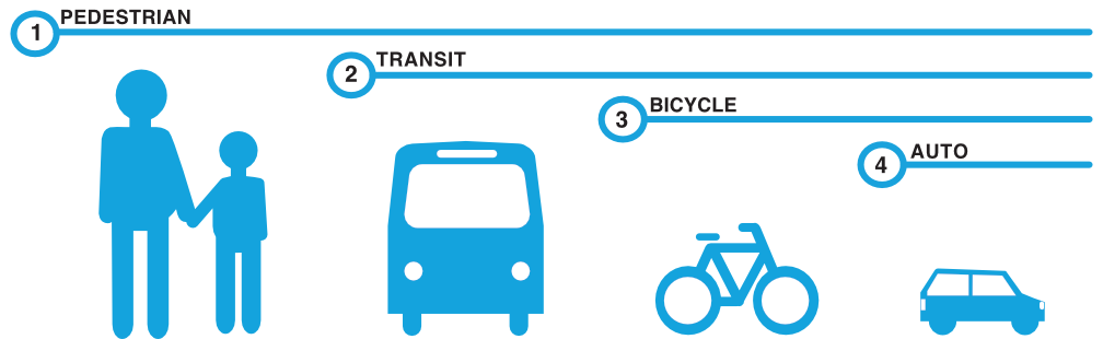
I’ll start with my favorite of all time, from Complete Streets Chicago. Finding this graphic a number of years ago gave me a framing for what I want to see in our transportation system, and really changed how I think about and communicate about transportation.
Chicago Complete Streets mode share graphic
I just modified this for Sacramento. Why the switch between transit and bicycling? Until the county and region fund transit at a level that allows it to be effective, it is not going to be number 2. I wish it were, but meanwhile, I think bicycling takes number 2.
Chicago Complete Streets mode share graphic modified for SacramentoRead More »
I reviewed the Sacramento City Council agendas for this calendar year, 12 meetings, looking for the word climate. One mention in three months, seeking authorization to submit a Climate Adaptation Planning Grant Program application. That’s it. Has there been a report on the Mayor Climate Change Commission (2020) recommendations and implementation strategies? No. Has there there been an update on the city’s declaration of a climate emergency (2019)? No. Has there been an update on the Preliminary Draft Climate Action Plan, and progress towards a final? No. Has there been an update on Climate Change Adaptation? No.
There have been quarterly climate reports (scroll down to Climate Workplan) to the council from the Office of Climate Action and Sustainability, which are provided to council, but without looking at each council meeting video, I don’t know whether these generated any significant council discussion, or any requests for followup action or information.
The city has said we are in a climate emergency. But it doesn’t seem to be acting like it. I realize that housing and homelessness are very high priorities, and should be, but ignoring climate can’t end well. Particularly since climate and transportation and housing are so closely linked.
Obviously there are different kinds of streets that serve different purposes. One of the simplest is street-stroad-road, the Strong Town concept that there should be only streets and roads, and the combination is a failure which they have labeled stroads. But a two-category classification is probably too simple.
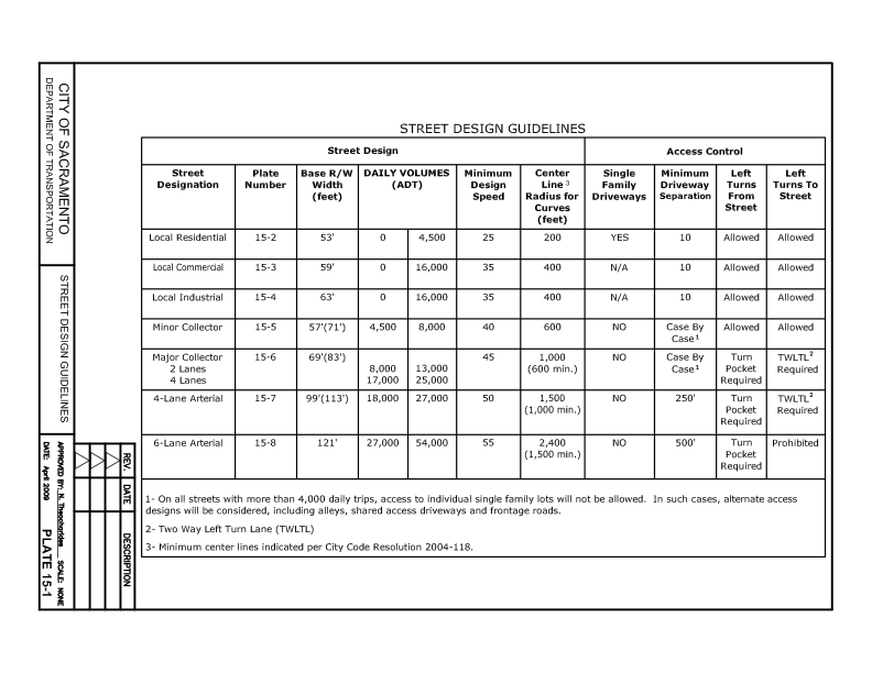
The existing City of Sacramento Street Design Standards (2009) offers the table below.
City of Sacramento street design classificationfunctional classification system
Both of these classification systems were developed for and reflect motor vehicle throughput. The more vehicles and the more speed, the higher the classification. This is the wrong way to go about designing roadways. It assumes that the primary purpose of roadways is to move motor vehicles. We know that is not true, or at least shouldn’t be true.
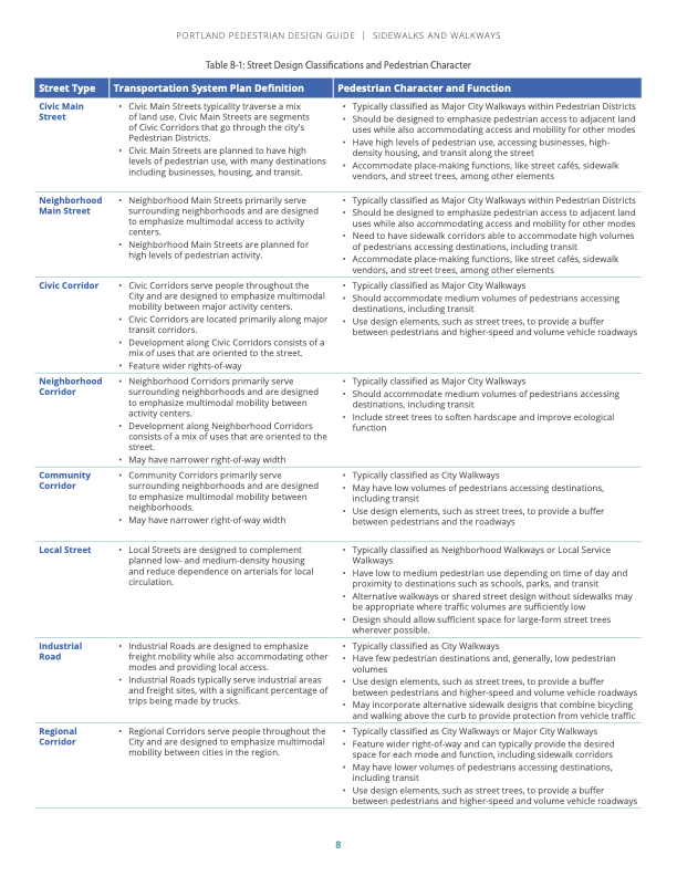
Portland (PBOT) uses a street classification system with eleven street designs, which are supplemented by five pedestrian classifications, four bicycle classifications, six transit classifications, and nine freight classifications. Yow! An advantage of the Portland system is that it includes details about each category, including land use, lanes, width, function, curb zone, separation, design elements, design treatment, and utilities. The Pedestrian Design Guide, simplifies down to eight classifications, shown below (pdf).
First, I believe that it is critically important that the city drop use of functional classification from its updated street design standards. Not only does the public not understand this classification system, it leads to roadways dominated by motor vehicles. That is not what we want in the city.
I don’t yet know what street classification system might work well for Sacramento, but I am certainly thinking about it, and researching for it. Probably not more than five classifications, for simplicity of understanding by the public, and so that the number of different designs are limited.
I have written about a three-classification system based on speed. That is a useful concept, and easy to understand, but it does not illuminate the surrounding land use nor the feeling and livability of the street. So rather than being a classification, speed limits (design and posted) should be set for each street classification, after the classification description is developed.
Streets should be designed from the outside in. They have traditionally and still are designed from the inside out, which means first deciding how much motor vehicle traffic to allow or encourage, and at what speed, then working outward to parking, transit, bike facilities, and sidewalks. This approach has given us the transportation system we have, which is rapidly changing the climate while not meeting the needs of most citizens.
If we plan outside in, we can have a better design, in every way. I don’t mean starting with the sidewalk, I mean starting with the land use. What land use is already there, or do we know will be there in 10-30 years, or most importantly, do we want to be there? What types of livable, economically vibrant places do we want? Then, and only then, what sort of design do we want to accommodate walkers (and rollers) who will access those land uses? What trees do we need to shade and shelter those walkers (and reduce utility bills for the buildings), and what other sidewalk-related amenities do we need for those walkers, and that land use? Benches, bioswales, dining, bike and scooter parking? What sort of bicycle facilities do we need to allow people using bicycles, bike-share, scooter-share, etc. to access that land use? What sort of transit facilities such as bus stops and dedicated transit lanes (bus or rail) do we need to serve those land uses? And lastly, what sort of motor vehicle facilities do we need? Do we need parking? What number and width and direction of general purpose travel lanes do we need? There may be some space left over for motor vehicles, once all the other needs have been met.
You might think I am being facetious, that motor vehicles should be accommodated in left over space. But I am serious. In most cases we don’t need motor vehicles on many streets. We think we do because we have designed streets that way, and encouraged people to think that way, that cars are the main mode of transportation. But there are examples of streets all over the world, and even a few in the US, that don’t allow motor vehicles at all, or if so, under very controlled circumstances. These include car-free or car-light boulevards, all the way down to woornefs, where motor vehicles are guest subservient to all other uses.
A Google search for ‘photos boulevards without cars’ interestingly produces hundreds of photos of streets with cars, and cars on streets, and mostly, car crashes. But Wikipedia has photos of woonerf, and Google did find one photo of a proposed street redesign for NYC produced by PAU architecture practice.
woonerf street in Utrecht, Netherlandsproposed people street design for NYC
Given the issues raised by the need for wider bikeways to accommodate wider devices and passing, the topic of my bike lane widths post, I am starting to think more and more about sidewalk-level bikeways, where the bikeway is at the same level as the sidewalk, and not at street level. The street-edge curb provides a good separation between motor vehicles and bicyclists and walkers (not perfect, drivers do ‘accidentally’ or intentional cross curbs). I am concerned that as street-level bikeways become wider, there will be more and more motor vehicle intrusions.
Here are are two diagrams from the Portland Bureau of Transportation (PBOT) Pedestrian Design Guide (2022), page 28. The first uses a tactile divider between the sidewalk and bikeway, the second a buffer similar to the regular sidewalk buffer, but with reduced width due to the greater separation from motor vehicle traffic as compared to regular sidewalks. Note that the street classification system that PBOT uses is interesting, but probably more than is needed in Sacramento for the Street Design Standards update.
I just came across the NACTO publication Designing for Small Things With Wheels, released February 2023. I’m still digesting the publication, which is available online for download. Already it has been eye-opening for me, a person who used to keep up with bikeway designs, but hasn’t paid much attention recently.
The working paper’s basic premise is that bikeways must be designed for the modern complement of devices, with widely varying widths, and also that bikeways must be designed so that people can safely and easily pass each other. Bike lanes have gradually evolved from 4 feet to 5 feet to 6 feet, but at least in Sacramento and the region, have not gone beyond that. But the working paper indicates that we need to start with 8 feet, to accommodate cargo bikes which are becoming much more common in the region, and go up from there. A chart from the working paper is below (page 11).
chart for bikeway width, NACTO Designing for Small Things with Wheelschart for two-way bikeway width, NACTO Designing for Small Things with Wheels
Given that I believe that motor vehicle design speeds over 30 mph require separate bikeways to keep riders of all ages and abilities safe, this means future separated bikeways should be a minimum of 8 feet. However, bikeways this wide encourage motor vehicle drivers to use them for travel, and to park in them, ‘for just a moment’ or longer. My take is that this means we must create bikeways that are at the sidewalk level, or if street level, that are completely protected by hard infrastructure such as curbs. Paint and vertical delineators (soft hit posts) will not do it. So, I need to throw out all the previous designs that I’ve suggested for streets with protected bikeways. I also need to give serious consideration to sidewalk-level bikeways that place a curb between any motor vehicle use and users of small wheels. Where does that leave parking protected bikeways that use parked cars as the buffer, at least when the parked cars are there? I’m not sure. Like I said, this is eye-opening and I’ll need to do a lot more thinking and research.
What I still do think is that bike facilities necessary depend on street design speeds (which are not currently but should be the same as posted speeds)
20 mph or less – no bicycle facilities needed
21 to 30 mph – standard bike lanes (Class 2 in California)
above 30 mph – separated bikeways (Class 4 in California)
Yes, this does affect what I was thinking about writing for bicycle facilities in my series on the City of Sacramento update of Street Design Standards.
Part of an ongoing series of posts to support better streets in the City of Sacramento during their 2023 update of Street Design Standards. New standards must be innovative, safe, and equitable, and it will take strong citizen involvement and advocacy to make them so.
The streets we have are largely for cars and car parking. In this, I include trucks and delivery vehicles. Streets are only incidentally for walkers, bicyclists, economic vitality, and urban life. We know that our urban environment must change, to meet the challenge of climate change, but also to create a place where people thrive.
SPUR, a San Francisco Bay Area education and advocacy organization, has done as good a job as I’ve found so far with the words to describe where we are going and how to get there. Their Transportation page includes:
Our Goal: Make walking, biking, taking transit and carpooling the default options for getting around
SPUR’s Five-Year Priorities:
Improve the region’s transit network, and the institutions that run it, so that all people have fast, reliable access to their city and region.
Make it faster, easier, more dignified and less expensive to get around without a car.
Leverage transportation investments to build great neighborhoods and connect people to opportunity.
As a point of comparison, the City of Sacramento, Department of Public Works, Transportation Division says:
The Transportation Division’s primary focus is maintaining and enhancing traffic operations, traffic safety and multimodal mobility for our citizens and customers.
Wake me up from my nap!
I have started working on transportation principles for Sacramento. I admit that the points and wording below are not yet succinct and powerful, but I’m offering them now so that you have an idea where I’m going. I will work on improving them, and post the improvements again at the end of the series.
Street Design Principles
Street design will ensure the safety of all street users; Vision Zero rejects any street design that allows fatalities or severe injuries for any street user
Street design will encourage walking, bicycling, and transit use, and will discourage unnecessary motor vehicle use
Street design will rank safety, livability and economic vitality above vehicle throughput or speed; congestion relief will not be a goal in street design
Street design will actively support the city’s goal of reducing greenhouse gas emissions (GHG) through reduction of vehicle miles traveled (VMT)
Streets can and will be redesigned to better serve current and future need; past design which may have met past need need not be retained
Interim solutions to safety or capacity issues will be identified for immediate implementation whenever permanent solutions are not yet budgeted; design diagrams for these interim solutions will be provided along with the permanent solution diagrams
My posts and city design standards should use these definitions:
‘Walking’ and ‘walkers’ includes mobility devices; the term pedestrian will not be used except in reference to laws or designs which use that term
‘Bicycling’ or ‘bicyclists’ includes any devices permitted by state law or city code to use bike facilities
‘Street’ includes all roadways which are not freeways or expressways, even if they do not currently meet standards for safe, equitable, or effective streets
Your suggestions on words and ideas are welcome! Comment below, or email me.
There are a few streets in Sacramento which are wide enough to host many activities and modes of travel, with reallocation of the roadway width to meet a new vision of a livable, walkable city. Two NACTO diagrams are below. The first, a downtown one-way street, is interesting to me because it shows a better use of space without having to change from one-way to two-way. I have always been opposed to one-way multiple lane streets because they present the multi-lane threat to people crossing the street, when one driver stops but others do not. This is one of the most common causes of fatalities for walkers, and why it must be eliminated. However, if the design is changed, the street becomes much safer, and the multi-lane threat is reduced or eliminated. Check the NACTO page for an alternate design.
NACTO downtown one-way street
I believe there should be high frequency bus service on J Street from 5th St to the university, and if J Street remains one-way, paired service on L St. This diagram would be a great model. Current service is 15-minute frequency on part of the route, but only 30-minute on part. Service should be at least 10-minute, maybe even more frequent. This would be a good design for that service and for those streets. Yes, L Street is not continuous, due to a broken street grid, so either H Street or Folsom Blvd could be used to connect.
Other streets that might remain one-way, but only with redesign, include the 9th-10th couplet, 15th-16th couplet, 19th-21st couplet, and P-Q couplet. The W-X couplet that bounds the Hwy 50 freeway would have to remain one-way due to freeway onramps and off ramps, but must be narrowed significantly. It is nothing but a traffic sewer as currently designed, and the motor vehicle capacity of the street is completely unneeded, even during rush hours.
The street has typical modes: motor vehicle lanes, bicycle lanes, parking areas, wide sidewalks. Features include curb extensions, short left turn lanes but long center medians, pedestrian scale and intersection lighting, planting strips with trees, but perhaps less than the yield street. The most important aspect is that there is only one general purpose travel lane per direction, meaning that the prudent driver controls the speed of other drivers. The design speed and posted speed might be as high as 30 mph, but would probably be less.