Bike Score

Bike Score for Minneapolis, with “heat map”

Walk Score/Bike Score offers an assessment of the bikeability of any location. It is available in any browser at https://www.redfin.com/how-walk-score-works. The Redfin app shows walk score, bike score and transit score for each listing (scroll way down). Walk Score is based on the distance to the places people want to go, such as grocery stores, restaurants, coffee shops, bars, movie theaters, schools, parks, libraries, bookstores, fitness locations, drug stores, hardware stores, and clothing & music.

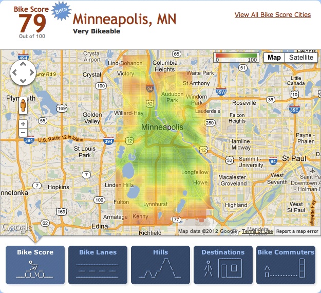
The next stage from the folks at Walk Score, Bike Score, is now available, for a select 10 cities. There aren’t any big surprises, Minneapolis, San Francisco, and Madison are at the top.

Sacramento is not on the list of 10. If you’d like to see it there, you can go to the Bike Score page and tweet a vote for it. Please do!

Walk Score also recently released Transit Score, where Sacramento is listed, as 22 out of the 25 largest cities with accessible transit data, at a score of 32. Both the Bike Score and Transit Score are created at a city-wide level, unlike the address-specific Walk Score. So these rankings are just first steps, but nevertheless interesting and useful.

You may have seen articles in the media recently about the high correlation between walkability and housing prices, with walkable communities in high demand and unworkable suburbs in the doldrums. This is good news for all of us. Walk Score was in fact designed as a tool for helping people find real estate and apartments in places that fit their desired lifestyle. As the correlation between walkable, bikeable, transit-dense communities and livability becomes more clear, resources (societal and personal) will be shifted away from the suburbs to urban areas.

Bike to School Day

Mariemont Elementary, full bike racks on Bike to School Day

Today, May 9, is the first official Bike to School Day (BTSD).

Mariemont ES in San Juan USD had 78 bicyclists, all wearing helmets.

I’ll be posting more local information as it becomes available, but here are some national posts to get started.

League of American Bicyclists blog: Happy Bike to School Day

Fastlane blog (US Department of Transportation Secretary Ray LaHood): First-ever National Bike to School Day gets kids on two wheels–safely

May Is Bike Month

The month has started, and I’m logging my miles at May Is Bike Month, which is for the greater Sacramento region. I’ll be out of town for 10 days this month, so my mileage will be lower than usual, first a trip to Arizona without my bike, and then a backpack trip without my bike, and maybe even a second backpack trip. Oh well.

I’m logging my miles under San Juan Unified School District, my employer, though there are several other connections I have. May is Bike Month also has a Facebook presence, which seems pretty active already.

Arena thoughts

The SacBee headlined Saturday, “Arena Deal Dead.” I never really cared that much about the idea of a new arena for the Kings. I’m not a big sports fan, and of all the sports, I think that professional basketball is the most boring of them all (not so for college ball). Whether the Kings play […]

Transit Score

Walk Score/Transit Score offers an assessment of the transit access of any location. It is available in any browser at https://www.redfin.com/how-walk-score-works. The Redfin app shows walk score, bike score and transit score for each listing (scroll way down). Walk Score is based on the distance to the places people want to go, such as grocery stores, restaurants, coffee shops, bars, movie theaters, schools, parks, libraries, bookstores, fitness locations, drug stores, hardware stores, and clothing & music.

I previously wrote about Walk Score and its use in Sacramento, and now the Walk Score company has released Transit Score. Sacramento ranks 22 out of 25 cities, with a Transit Score of 32 (of 100), in the category of “some transit.” The categories are rider’s paradise, excellent transit, good transit, some transit, and minimal transit. It is worth noting that if all the major cities had provided their transit information, Sacramento would probably have not been on the list at all, because with a population of just under a half million, it is not in the usual top 25 but would show up in a top 50.

Walk Score notes “The Transit Score algorithm calculates a score for a specific point by summing the relative ‘usefulness’ of nearby routes. We define usefulness as the distance to the nearest stop on the route, the frequency of the route, and type of route.” As pointed out in the recent Streetsblog post, it does not including information about where you can go once you’ve gotten onto the transit, which also of course affects the usefulness of the transit.

Read More »

Two-waying streets in SF

StreetsBlog San Francisco had an interesting article yesterday about the conversion of one-way streets to two-way streets, SFMTA Brings Humane, Two-Way Traffic Back to Ellis and Eddy. This is an idea I’ve mentioned before for midtown, but haven’t posted any details yet, and still am not ready yet. But this article builds the justification. The […]

SACOG transportation plan

An interesting SacBee editorial, SACOG sets high bar on transportation plan. SACOG is the Sacramento Area Council of Governments, responsible for overall planning and much of the distribution of transportation funds for the region. The plan funds transit, state highways and local roadways, and pedestrian/bicycle facilities. I’ve reviewed the Metropolitan Transportation Plan 2035 (MTP), and […]

Sprawl

This week’s Sacramento News and Review (Thursday, April 29, 2012) has a feature story titled “Onward, Sprawl,” highlighting the impacts of the passion for growth of Sacramento County, Folsom, Rancho Cordova, and Elk Grove. I highly recommend a read. The Sacramento Bee has a short article in the Wednesday, April 18 edition titled “County kicks […]