Floating bike lane on I Street

This is a follow-on to The I Street mess, and is another example of poor sharrow placement. Thank you, Elle, for reminding me to write about this.

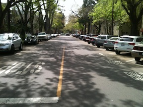
On I Street between 7th and 6th streets, there is a floating bike lane on the north side. A floating bike lane, also called a part-time bike lane, is one that is designed to be a parking lane for part of the day and a motor vehicle travel lane for part of the day.

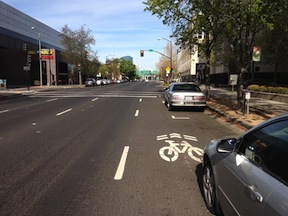
The first photo below is the lane when parking is prohibited, and it is a shared motor vehicle travel lane. The signing indicates that parking is prohibited from 4 to 6PM on weekdays. This is in order to provide more lanes for the flush of traffic heading to the freeway during the afternoon rush hour. There are sharrow markings at the beginning and near the end of the block, to reinforce the “bikes may use full lane” sign (MUTCD R4-11).

The next photo shows the same floating bike lane when parking is allowed, the rest of the time. As you can see, the sharrows are partly covered by parked cars. The remaining width of the lane, which forms a de-facto bike lane, is too narrow for a lane adjacent to parked cars and is unsafe. In this particular location in front of the county jail, it is doubly unsafe because frequent turnover in cars (one hour limit) and the type of people who park here, not the sort to be thinking of bicyclists before they open their car door. In fact, guidance on floating bike lanes recommends against their use in situations with high-turnover parking.

I Street floating bike lane during parking prohibition
I Street floating bike, parking prohibited
I Street floating bike lane, parking permitted (Elle Bustamante)

I never ride in this floating bike lane when there are parked cars, I always ride in the full travel lane to the left, but I often get honked at by drivers who think I should be in the “bike lane,” and don’t realize it is not a safe place to ride.

There is nothing inherently wrong with floating bike lanes. A number of cities use them in cases where they perceive a need to carry high volumes of motor vehicle traffic at certain times of day, but want to accommodate bicyclists at other times. They are always seen as a compromise that doesn’t make anyone completely happy. However, this is the only instance that I’m aware of in Sacramento, and it is not signed and marked in such a way as to communicate its purpose and use to either drivers or bicyclists. It needs to be crystal clear for everyone, or be removed. Maybe it is time for this floating bike lane to sink.

This section of I Street is the logical main access route for bicyclists to the train station. Rush hour for cars is also rush hour for bicyclists. What I see during this time of day (4-6PM) is a lot of bicyclists riding the wrong way, or on the light rail tracks, along H Street in order to access the train station. It is worrisome to me that that I Street was not designed with bicyclist safety in mind. Bicyclists feel that it is safer to ride against traffic on H Street than with traffic on I Street, despite the fact that wrong way riding is the leading cause of bicycle-motor vehicle crashes, or to risk spills getting caught in the light rail tracks, anything to avoid I Street. I have seen several bicyclists fall on the light rail tracks here.

I Street in this section could be made safe for bicyclists in two ways:

  1. Remove parking from the left side of I Street and shifting travel lanes to the south so that a full 6.5 foot bike lane could be installed. The sharrows would not then be needed. Or, 
  2. Make the right hand lane a full-time parking lane and move the sharrows into the next travel lane to the left.

Given that there are bike lanes both east and west of this block, option one is probably the best because it would create a continuous bike lane, but option two is workable.

The I Street mess

Thank you, Elle, for reminding me in your “transportation ‘planning’ downtown” that I wanted to write about I Street. Note: If you are looking at Google Maps, it does not show the current lane configuration on I Street since the repaving and re-striping project of last fall, nor the realignment of tracks and work on extending 5th and 6th streets over the tracks.

I Street from the 4th Street crosswalk
I Street from the 4th Street crosswalk; I have the walk signal but this is still scary

I Street in Sacramento approaching the train station is a mess. Starting with the confusing floating bike lane between 7th and 6th streets (subject of a future post), the street becomes worse and worse: five lanes wide, high speed, and completely unfriendly to bicyclists and pedestrians. For pedestrians, the crossing on the east side of the I/5th intersection is uncomfortable because westbound traffic is already moving at high speed and often runs the red light, and right turning cars from I to 5th often do not yield to pedestrians in the crosswalk. The west side is so unsafe due to traffic turning left off 5th Street, it is signed against pedestrian crossing, even though this is a logical walking route from downtown to the train station. A crosswalk has been added on the east side of the I/4th intersection, but it has the same challenges that drivers are moving too fast and often run the run light. When I used this new crosswalk, I was very concerned, and I have a much higher tolerance for danger than most people do.

The right-most two travel lanes lead to the high-speed northbound I-5 freeway onramp, so drivers passing 6th Street are already accelerating to freeway speeds, many times going 55 mph as they cross through the I/5th intersection. The next two lanes lead to a medium speed onramp to the I Street bridge over the Sacramento river, and to the southbound I-5 onramp. For pedestrians, the only way to go westbound towards Old Sacramento is to go through the parking lot for the train station and under the onramps along an ugly, dark, poorly marked pedestrian way.

Read More »

legislation update

There are several bills before the California Legislature that would affect bicycling, walking, and livability.

added: AB-184: Statute of limitations: lengthens statue of limitation for hit and run, probably a good bill

AB-206: Vehicles: length limitations: buses: bicycle transportation devices (SacRT): added complicating language, but still good

AB-417: Environmental quality: California Environmental Quality Act: bicycle transportation plan: no changes so far, a good bill

added: AB-666: Automated traffic enforcement systems: violations: red light cameras, it restarts the program, but with civil rather than criminal penalties, supported by CaliforniaWALKS and California Bicycle Coalition

AB-738 Public entity liability: bicycles: no changes so far, still a bad bill

AB-840: Vehicles: driver’s licenses: application requirements: stripped of all bicycling knowledge language, now only requires that drivers license applicants acknowledge the dangers of distracted driving

AB-956: Vehicle accidents: fleeing: no changes so far

AB-1002: Vehicles: registration fee: sustainable communities strategies: changed to remove urgency language and detail use for sustainable communities; still a good bill

AB-1179 Regional transportation plan: sustainable communities strategy: schoolsites: language slightly diluted, still a good bill

AB-1193 Bikeways: allows cities and counties to use industry standards rather than the requiring the use of the Highway Design Manual; language improved, a great bill

AB-1194: Safe Routes to School Program; maintains SRTS program at state level, added non-infrasture, statewide coordinator, and TARC; better

AB-1371: Vehicles: bicycles: passing distance: this bill originally had a different purpose, and was revised to be a three foot passing law, it looks to me to be good

Please let me know if you are aware of any other bills. I’ve signed up for tracking on these particular bills, but may not be keeping up to date.

sharrow problems

My post on the new downtown bike lanes, shortly after the work was completed in fall 2012, had some mild criticism of the placement of sharrows. After many months of riding on these particular streets, and observing how bicyclists and motor vehicle drivers respond to their placement on the roadway, I am now prepared to criticize the sharrow placement more strongly.

The California MUTCD section 9C.07 specifies that shared lane markings (commonly called sharrows) must be at least 11 feet from the curb where parking is present. Either traffic engineers or paint crews, not sure which, are taking this to mean that the sharrows should be placed exactly 11 feet from the curb, as many of those in the recent Sacramento project were. The NACTO Urban Bikeway Design Guide has a better recommendation, “On streets with posted 25 mph speeds or slower, preferred placement is in the center of the travel lane to minimize wear and encourage bicyclists to occupy the full travel lane.” However, the NACTO guide has not been recognized or adopted by either the state or Sacramento, and in fact some vehicular cyclists are opposed to the NACTO guide because it promotes separate facilities over riding in traffic, but that is a conversation for another post.

One of the purposes of the sharrows is to guide bicyclists about the best place to ride in situations where bike lanes are not present and the lane is too narrow to share, 14 feet or less. When sharrows are placed to the side of the travel lane, they are too close to parked vehicles and their car doors. Doors on some two-door vehicles come out an amazing 54 inches from the side of the car. So if the side of a parked car is 7 feet from the curb, the door comes out 11.5 feet, more than the minimum specified in the MUTCD, and that does not even count handlebar width and shy distance. Eleven feet is not a safe placement. Many bicyclists know that this is not safe, and therefore ride in the middle of the travel lane, but since they are no longer riding on the sharrows, motor vehicle drivers think that they are riding in an illegal fashion and do the typical immature driver things: yelling, honking, following too close, and intimidation through close passing. Yet if the bicyclist is riding on the sharrows, then many motor vehicle drivers feel that there is room to squeeze by in the same lane, thereby coming much too close to the bicyclist and endangering them. The only safe place for the bicyclist to be is in the middle of the travel lane, and that is where the sharrows should be.

Examples and solutions after the break…

Read More »

News summary March 31

Will Sacramento’s downtown grow in the whales’ wake? (SacBee 2013-03-31)

Pedestrian killed crossing Auburn Blvd. is identified (SacBee 2013-03-30)

The $250 Million Challenge: Downtown Streetcar Corridor (Sacramento Press, 2013-03-29); Opinion: What else could $250M buy us? (Sacramento Press, 2013-03-27)

Northwest Land Park Demonstrates Home of the Future (Sacramento Press, 2013-03-28); Northwest Land Park infill will feature green homes (Sacramento Business Journal, 2013-03-29); remember that the biggest carbon impact of a house is how the residents get around, not the house itself

After bypass, what now for Lincoln Boulevard? (Sacramento Business Journal, 2013-03-29); why is this part of the planning following the bypass, rather than having been part of planning from the beginning?

California to again crack down on distracted driving (SacBee 2013-03-27)

Arena Plan Puts the “King” in Parking (Sacramento Press, 2013-03-26)

Highway 99 interchange work to begin in May (Sacramento Business Journal, 2013-03-25); $31M to spur development in a greenfield area? What else could we be doing with this money?

New I-5 interchange may be start of first big housing project in years (Sacramento Business Journal, 2013-03-22); At least this $83M is private money, but it is still greenfield development.

And just to prove that I’m not against all development, here are two infill projects that make sense to me:

wrap-up of changing downtown/midtown

Nine posts (linked below) have outlined my thoughts about how to create a livable, walkable, bikeable and safe downtown/midtown Sacramento. These have been nearly all from a transportation perspective, how we change the way people get around. Though I will continue to post on these topics, I want to wrap up for the moment. I need to pay attention to some other things, and I need to finish my taxes!

Livability is not created merely by transportation changes – it takes a lot more than that. But it does provide fertile ground for the changes that are needed. I am pleased to know of and be a small part of efforts to transform downtown/midtown. I attended CivicMeet Sacramento on Wednesday, where the participant selected topics were save the bikes (bike theft), rooftop utilization, fresh fruit and veggies downtown, and human capital clearinghouse. I attended the Turn Downtown Around open forum two weeks ago. Good energy from (mostly) young people, directed towards creative solutions to making downtown/midtown a vibrant place. I’m sure there are many others working towards the same ends (many ends). It is sad that the city government is trailing, slowly, rather than leading, but it also an opportunity for creatives to step in and fill the gap.

Let me acknowledge that transportation is only a small part of the big picture, but I write about it because it is my small part.

and the freeways

I-5 separating Old Town from downtown Sacramento

Sometimes I catch a ride from a friend or take an Amtrak bus, and am on freeways in the Sacramento area, which most of the time I never see. I wonder why there are so many lanes for so few cars, so much expanse of empty concrete and expensive bridges. Of course I know the answer, the freeways have been built for two rush hours, morning and afternoon, on five days a week, perhaps 13 hours per week out of 168 hours in the week. Oh, and the Friday up to the snow or Tahoe and Sunday back home, that weekly migration of bay area people. The rest of the time they are largely empty.

Yet freeways take up a huge amount of space, have a huge carbon footprint for construction and maintenance even before fuel consumption comes into play, spew pollution into neighborhoods, and suck up the largest portion of our transportation funds. As an example of cost, the nine miles of the six-lane Capitol City Freeway (Business I-80) from Interstate 80 to Highway 50 is 54 lane-miles. Though the cost to construct a lane-mile varies widely, from $2M to $80 million, lets take a very conservative number of $5M and say that this section of freeway cost a quarter of a billion dollars. And this is not even an expensive highway, with its simple interchanges. Pretty amazing, huh? What else could we have done with that money?

Read More »

what to do with recovered street width

When 3-lane streets are narrowed to 2-lane streets, street width is recovered for other uses. Traffic lanes are commonly 12 feet wide, though they can be as narrow as 9 feet and as wide as 14 feet or more. Most streets in the downtown/midtown area that I’ve recommended for narrowing are really five lanes wide, three traffic lanes plus two parking lanes. Eight ways in which this recovered right-of-way width can be used:

  1. Widen sidewalks: In some areas, sidewalks are too narrow to carry the number of walkers using them. For example, on 16th Street between P Street and O Street, the sidewalk is much too narrow to handle the foot traffic. There are six businesses on the east side of the street: Pronto by Paesano’s and the associated Uncle Vito’s Pizza, Super Cuts, Nishki Sushi, and Starbucks, plus a storefront that is being refurbished to be Thai Canteen. These generate a lot of customers on foot and on bike, and the narrow sidewalk is frequently crowded.
  2. Add sidewalk buffers: In cases where the sidewalk is immediately adjacent to the street, or a there is a buffer but it is too narrow, width can be devoted to these buffers. Sidewalks with buffers are called detached sidewalks. These may not appropriate in commercial areas because the isolated high-turnover parking from the sidewalk, but are completely appropriate in residential areas and may be in mixed areas.
  3. Add bicycle lanes: Bicycle lanes take up five feet of width if adjacent to the curb, and six feet if adjacent to parking. (AASHTO standards are a minimum of four and five, but these widths are unsafe.) Normally a street will have bike lanes on both side, so two bike lanes will take about the same space as one traffic lane. If we were to otherwise leave the street system as it is, with high speed one-way streets, the protection of bike lanes is critical to making downtown/midtown more bikeable. However, if the recommendations I have made were implemented, streets would move more slowly with lower volumes of traffic, and bike lanes would be less necessary.
  4. Add protected bike lanes: A protected bike lane (cycle track) is a protected bike way, with some sort of physical protection from motor vehicle traffic. The protection can be a painted no-vehicle area, hit posts, curbs, parked cars, or a surface raised to a level between the roadway and the sidewalk. Because the protection takes up space, in many situations only a single protected bike lane can be gained from the removal on one traffic lane.
  5. Add dedicated transit lanes: Bus routes on streets with heavy traffic are often slowed by congestion and by turning vehicles. Both bus and light rail can be sped up by removing some of the conflict with dedicated transit lanes. Long distance dedicated lanes can be used to create bus rapid transit routes, but short segments of lanes can be useful for solving spot congestion problems. If light rail and buses run more freely, transit times are reduced and people will be more likely to choose transit over privately owned vehicles. It is not clear to me at the moment whether any of the 3-lane streets are logical locations for dedicated transit lanes, but I will look at this in the future.
  6. Create wide medians: Medians can be created along the middle of the street, separating the two travel directions. These medians can have plantings, artwork, rainwater basins, sitting areas, and a number of other amenities that may be absent along the street. These parkways or boulevards are probably not appropriate in commercial areas, but would be in residential or mixed areas.
  7. Convert from parallel to diagonal parking: Conversion from parallel parking to diagonal parking (60 degree reverse angled parking) uses up about 8 feet of street width, and roughly doubles the amount of parking. Because parking takes more of the street width, it is even more important to consider curb extensions (bulbouts) to increase pedestrian – driver visibility at intersections and mid-block crossings.
  8. Create center turn lanes: If the street is also being converted from one-way to two-way, the center lane can become a turn lane. I think that this is the least useful of the solutions because it serves a single and not very common need, left turns, with an entire dedicated lane. If the traffic on a street is so heavy that it is difficult to make left turns, a left turn pocket or a block-long center turn lane can be provided every four to eight blocks, but having a continuous lane is just a waste of precious right-of-way.

Certainly not every solution is right for every situation, and each roadway segment should be analyzed to determine the best overall use of the width recovered from 3-lane to 2-lane conversion.

diagonal parking

I’ve suggested using up excess street width with diagonal parking. Below are two photos of 17th Street in midtown, one of the section between N and O, which has parallel parking, and a much-too-wide street width. The second is between O and P, which has diagonal parking on the west side. Since these are right next to where I live, I get a regular chance to observe the behavior of drivers on these two sections. On the parallel parking section, drivers are almost always moving above the speed limit, about 30 mph, particularly since most of them have come from an overly-wide section of 17th north of N Street. On the diagonal parking section, drivers are almost always moving at less that the speed limit, about 20 mph. A more subtle difference is that northbound drivers, from the diagonal parking section, seems more willing to yield to pedestrians at the unmarked crosswalks at the intersection of 17th and O streets, whereas southbound drivers, from the parallel parking section, seems to be less willing to yield. Narrowing streets with diagonal parking really does make a difference!

17th St parallel parking
17th Street parallel parking
17th Street diagonal parking

more on conversion to two-way streets

A friend suggested that my streets change ideas were hardly new, and that is quite true. Some streets were converted in the past, some were identified for conversion but not completed, and many more have been suggested but not adopted by the city. Here are some additional references.

Some news articles about past and planned conversions in Sacramento:

References on past and planned conversions in Sacramento:

Articles and references on the one-way to two-conversion concept:

Note: There are a number of contrarian views available from the cars-first crowd. You can search for the Internet for “two-way conversion” if you want to find them.