- Plan to replace downtown’s Hotel Marshall moving forward (SacBee 2015-02-22)
- Keep the strong momentum going for streetcar line (SacBee 2015-02-19)
- State must spend smarter on roads and ‘fix it first’ (SacBee 2015-02-19)
- East Sacramento County expressway takes step forward (SacBee2015-02-19)
- Construction to improve Old Sacramento traffic access could begin this summer (Sacramento Business Journal 2015-02-19)
- Engineering work beginning for Capital Southeast Connector project (Sacramento Business Journal 2015-02-19)
- Property owners vote for Sacramento streetcars (SacBee 2015-02-19)
- McKinley Village gets approval for underpass (Sacramento Business Journal 2015-02-18)
- County to reduce sign clutter on American River Parkway (SacBee 2015-02-17)
- Placer County Subsidizes Bicycles To Get Cars Off The Road (CapRadio 2015-02-17)
- Helmet law isn’t only route to safety for bike riders (SacBee 2015-02-16)
- Sacramento overhauling vintage train station (SacBee 2015-02-16)
- An urban shift toward West Sacramento (SacBee 2015-02-16)
News summary 2015-02-15
- Bill would require helmets for adults cycling in California (SacBee 2015-02-13)
- Streetcar line is a strong investment (SacBee 2015-02-11)
- Senator calls for mandatory helmets for California cyclists (SacBee 2015-02-11)
- Railyards, K Street redesign at core of Downtown Sacramento Partnership agenda (Sacramento Business Journal 2015-02-10)
- How about honesty and transparency on road fees? (SacBee 2015-02-10)
- Sacramento considering half-cent county transportation sales tax (SacBee 2015-02-09); New Light Rail Extension to Sacramento Airport Proposed, Comes at a Cost (Fox40 2015-02-10)
- Home on the Range (Comstock’s 2015-02-06)
#StuckInTraffic
There was a Twitter townhall today hosted by Secretary of Transportation Anthony Foxx and House Transportation Infrastructure Committee Chair Bill Shuster, organized around the Twitter hashtag #StuckInTraffic. I was expecting the worst, given that the hashtag presupposes that the main issue is congestion, but was pleasantly surprised. The questions they answered were softball questions, but the cars-first, highways-only message was absent in their answers, and that has to be a good sign.
The #StuckInTraffic hashtag has all the related tweets and provides a wider range of opinions, but other than the Heritage Foundation cars-only fringe pushing their Transportation Empowerment Act, there was a surprising across-the-board support for a true multi-modal transportation system.
I believe that we should have a multi-modal system, but I also believe that we have already spent enough money on highways and stroads, and that we should now be spending money only on maintenance, walking, transit and bicycling. What multi-modal should mean going forward is that we make up for our past cars-only mistakes by not spending any more on that ultimately dead-end enterprise. One of my favorite transportation graphics of all time is below, showing Chicago’s transportation priorities. Though the mix may be different in different locations, it is good place from which to start discussions at all levels, federal, state and local.

SHSP Update
 This is one of the nerdier posts I’ve written in a while, and much of it probably won’t make sense to anyone who has not been involved in SHSP. Why is it important? Because all of the safety funds in California, some of the transportation budget, and much agency effort go to the priorities identified by SHSP. In the past, that has meant a focus on the safety of motor vehicles drivers, focus to issues such as distracted and drunk driving (which are important but not everything), and in a perversion of priorities, stings on pedestrians and bicyclist funded by OTS.
On November 14, 2015, the SHSP (Strategic Highway Safety Plan) Safety Summit was held on the CSU Sacramento campus, part of the SHSP Update process that seeks to revised the Strategic Highway Safety Plan for California. The summit was very well attended, nearly filling the ballroom. After some introductions from various agencies (Caltrans, Office of Traffic Safety, and California Highway Patrol are the main partners in the program, but several other agencies participate), there were six breakout sessions to provide input on different topics, and an opportunity to participate in two of the six.
I participated first in the Active Transportation (bicycling and walking) breakout, which was facilitated by Katherine Chen & Jill Cooper. Issues identified: we really don’t know why there has been an increase the last few years in bicyclist and pedestrian injury and fatality, whether due to increased mode share or some other reason; the CHP 555 form and SWITRS database do not offer all the information we need; there is almost no injury/fatality rate data available because agencies are not collecting counts; rather than transportation funds being allocated based on injury/fatality rates, bicycling and walking receives a tiny portion construction and safety funds. The session went well, with good discussion and a lot of good information gathered onto charts by Katherine.
I also attending the Infrastructure and Operations breakout session, which was facilitated by two individuals from Cambridge Systematics, the contractor being used for the update process. This session did not go well. The participants provided thoughtful input, but much of it was rejected by the facilitators, either not written onto charts, or crossed out because they didn’t agree with it. The group wanted to use rates rather than counts, education is needed to create a culture of safety, distracted driving is epidemic, automated enforcement of red lights and speed are critical to changing behavior, and we need to focus on intersections since that is where most problems occur. The facilitators wanted to hear none of it, and were disappointed that no one seemed interested in spending money on “improving safety” for motor vehicle drivers by building more highways.
We were promised at the summit that the breakout session notes would be tabulated and made available to participants “soon.” As of today, 11 weeks later, no information has shown up on the SHSP Update web page. I doubt that the information will show up before the process is complete. I would guess that the contractor and Caltrans didn’t like what they heard and decided to suppress the information.
Despite the lack of input from the SHSP Safety Summits (there was one northern and another in southern California), the SHSP Steering Committee has been pushing forward with updating the SHSP strategies. The SHSP Bicycling committee (formerly Improving Bicycle Safety) on which I serve, and the other committees, were given a very short deadline to provide a new short set of strategies (up to five). It seems as though we will be locked into these for several years. In the committee’s January meeting we made remarkable progress on coming up with strategies, coming to consensus on a number of issues that we’ve discussed for years and never quite come to common understanding or agreement. When we ask where the Safety Summit information was, we were told by Pamela Beer of Cambridge Systematics that she had all the information we needed, that the printed notes that we were given at the meeting but not beforehand where all we would get, and that we should not expect to see any outcomes from the summit before the strategies finalized. Somehow she had inserted herself into our committee meeting as a facilitator/controller, without the knowledge of anyone on the committee.
The strategies adopted by the Bicycling committee, pending some wordsmithing, are:
- Improve roadway and bikeway planning, design, and operations to enhance bicycling safety and mobility while supporting bicycling to and from all destinations.
- Improve data collection regarding bicyclist trips, injuries and fatalities on California roadways and bicycle paths.
- Improve education and enforcement based on the protection of everyone’s right to travel by lawful means.
- Encourage more bicycle travel by improving public attitudes about bicycling safety and the need for safe and courteous behavior toward all roadway users.
- Develop safe, direct, and connected routes on which bicycling is a priority mode of transportation.
update on I Street

I wrote previously about the The I Street Mess. A small change has taken place here, with a new sign that says “Bicycles Must Turn Right” on the bike lane midway between 6th and 5th. Basically, this is a warning to bicyclists who missed the “Thru Bikes Merge Left” sign at the beginning of the block that they are truly screwed. By this point, bicyclist will have a very hard time merging across four lanes of high speed traffic to reach the left side bike lane that takes one to Old Sacramento or 3rd Street. At a minimum, the warnings need to occur earlier, in the block between 7th and 6th. Better yet would be slowing the traffic on I Street so that a bicyclist could actually maneuver through the traffic lanes. Best would be an alternate route for bicyclists who don’t wish to ride vehicularly, that avoids the I Street Mess completely.
News summary 2015-02-08
- Brown seeks money for fixing roads as gas tax value plunges (SacBee 2015-02-08)
- Another View: Caltrans making progress, but funding lags (SacBee 2015-02-08)
- Opinion: California’s roads need costly repair (SacBee 2015-02-06)
- Should Sacramento’s streetcars be modern or vintage looking? (SacBee 2015-02-05)
- Road user fee drives California Assembly Speaker’s transportation plan (SacBee 2015-02-04)
- Sacramento police investigating possible hit-and-run after man found lying in street (SacBee 2015-02-03)
- Feds on board with Sacramento streetcar (SacBee 2015-02-02)
walking the streetcar route

Today I walked the route of the proposed Sacramento Riverfront Streetcar. No, this is not part of the argument about whether pedestrians or streetcars are faster, going around the Internet recently, but I just wanted to see it all from a walking viewpoint, not on my bicycle. There is a map of the probable route on the website above, though oddly it leaves out some streets.
I picked up the route at L and 16th, just two blocks from my home, and headed west between Capitol Park and the brutalist Community Center Theater. The route turns north on 13th Street and apparently goes through the pedestrian plaza over to 12th where is would then use the SacRT light rail tracks (light rail would be routed to the north along H Street). The further west on K Street, the more depressing things are, with most buildings not only empty but abandoned. But, this is part of the reason for the streetcar, to support the economic redevelopment of this area. At 6th it heads north along the existing light rail tracks to H, and then west to Sacramento Valley Station (Amtrak).
improving SacRT
The condition and future of Sacramento Regional Transit (SacRT), particularly the light rail system, has been much in the news recently:
- Back-seat Driver: Tug of war at Sacramento transit agency
- Regional Transit working on improvements, in response to business community
- Editorial: Arena provides spark for fixing Regional Transit
- Sacramento transit officials agree their light rail service needs improvement
- Sacramento business leaders challenge RT: Clean up your act
Everyone these days seems to want a better transit system. The problem is that no one wants to pay for a better transit system. The business leaders who suddenly want a modern, appealing, well-maintained light rail are the same ones that have worked over the years to suppress efforts at increasing the tax base for operation of the system.
14 foot lanes
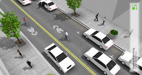
There has been a discussion on the Association for Pedestrian and Bicyclist Professionals (APBP) listserv for the last two weeks on what to do with an outside lane of 14 feet (without on-street parking), particularly when there is a seam between the asphalt pavement and the gutter pan. Several people encouraged the use of narrow, substandard bike lanes in an effort to get something on the street, rather than using sharrows in the wide lane, or just leaving the lane unmarked. I believe we need to be very careful to not create “bike lanes at any cost,” and to carefully consider the actual roadway conditions before specifying anything that does not meet or exceed standards. The diagrams below are from the NACTO Urban Bikeway Design Guide. The first shows a high quality bike lane adjacent to a curb; the second one shows sharrows rather than a bike lane where there is not sufficient roadways width.

Riverfront streetcar makes FTA budget list
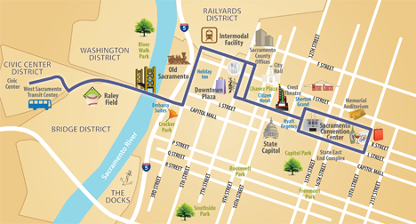 The list of transit projects put out by the Federal Transit Administration (FTA) as part of President Obama’s proposed 2016 budget includes $75,000,000 in Small Starts funding for the Sacramento Downtown Riverfront Streetcar. The FTA Project Profile is available with some detail that may be of interest.

