I often wonder if governments really focus on the issues rather than responding to incidents. In the case of pedestrians and the City of Sacramento, is the city really placing its attention, and its dollars, where they need to be to enhance the safety of pedestrians? I’ve created some maps to show where the problems lie (see note at bottom about data sources and how these were created).
The collisions mapped are:
Date: 01-01-2004 to 12-31-2012
Location: City of Sacramento only (no, I can’t explain why some are outside the city)
The first map, a point map of the entire city, shows:
the greatest density of collisions is in downtown/midtown, but there are certainly plenty in other areas
almost all collisions happen at intersections, not mid-block
almost all collisions are associated with major streets, called arterials and collectors, which are wide and high speed, intended to move motor vehicle traffic at speed rather than provide for multi-modal transportation
pedestrian collisions, killed or severe injury, point map
As mentioned in my recommendations for improving walkability in midtown/downtown, in response to the Sacramento Grid 2.0 program, I’ve developed more information including a map (at bottom) about the locations in the grid that are signed against pedestrian crossing. The signs at these locations may be the modern MUTCD R9-3a sign, shown at right, or the older text sign, shown below, or variety of non-standard signs. Update 2015-07-27: 37 locations.
There are a large number of other locations where crossing is discouraged by the lack of sidewalks, curb ramps, and crosswalks, but is not specifically prohibited.
As can be seen from the map below, the majority of the no pedestrian crossing locations are along the Capitol Expressway (Business 80) and US 50 freeways. These freeways, designed and constructed by Caltrans, are barriers to pedestrian use. In fact, they are a barrier to all use and livability because many of the grid streets do no continue under the freeways, making access more difficult for pedestrians, bicyclists, and motor vehicle drivers. In many cases there are no sidewalks on the freeway side of the adjacent surface street, so whether or not there is a safe or marked crossing doesn’t mean much without a sidewalk to connect to.
The City of Sacramento Grid 2.0 project is requesting specific input on ways to improve the pedestrian experience in midtown/downtown. I encourage you to go there and add your pins.
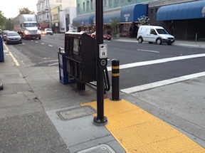
Pedestrian beg button on a commonly used crosswalk (K & 9th), this location should have a pedestrian signal on every cycle, not just when someone presses the button.
Dropping pins on a map, however, doesn’t allow some more general comments that I think are very important, and perhaps just as important as any of the corridor improvements shown. For me, these points are:
All signals and pedestrian signals in the grid should be set on automatic recall by default. That means that pedestrians get a walk signal on every cycle without having to find and press the beg button (many of which can’t be accessed by disabled people). If the city thinks that a particular crossing should require a button, they should have to do a traffic study to justify it, which includes both the requirements that 1) the level of pedestrian use if very low (unlikely in the grid, but possible), and 2) that there is a demonstrable delay in traffic due to automatic recall. This does not mean that pedestrian buttons will not be present, as there may be valid ADA benefits to having them, including the specific announcements now being included, but they should never be required.
In heavy pedestrian use area, if pedestrian buttons are present, pressing the button should actually shorten the signal cycle to provide for pedestrian crossing on demand, rather than just changing the pedestrian signal head when the signal goes through its regular slow cycle. No regular cycle should be longer than 90 seconds because long cycles unnecessarily delay pedestrian (and bicyclist) travel in favor of motor vehicle traffic.
All three-lane one-way roads should be reduced to two lanes. This will make street crossings safer (by about 1/3 – what other improvement could make such a difference!) and more comfortable. There is no excuse in a walkable urban environment for there to be three-lane one-way streets.
All no-pedestrian-crossing locations should be removed and replaced with regular high visibility crosswalks. Though these prohibitions are often justified by safety concerns, they are really just for the convenience of motor vehicle drivers, so that they don’t have to slow down or wait as long at signals. If a crosswalk is not safe, it means the roadway design is unsafe, and the correct solution is to change the roadway design, not to prohibit crossing.
The ability to safely and comfortably cross streets is just as important to people walking as the ability to walk along streets. I don’t know that this is the case here, but transportation agencies often get so focused on travel along corridors that they forget about the need to cross corridors. The grid pattern in midtown/downtown eases this problem, and is in fact one of the major benefits to a grid, but nevertheless, significant attention must be paid to crossing.
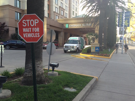
sign adjacent to Capitol Mall sidewalk at Embassy Suites
The sign at right is posted prominently at the eastern driveway of the Embassy Suites Sacramento, on Capitol Mall at Tower Bridge. The sign is illegal, as no sign on private property can direct people on public property what to do, particularly when the sign uses the standard red octagon which is reserved for official stop signs. But more importantly, it is offensive to anyone who walks. What is the hotel saying by posting this sign? That we welcome people who drive cars, who should not have to stop for pedestrians even on the sidewalk, and we reject people who walk, because they are second class citizens, not our customers? This sign has been here at least since December 2013, and I have talked to management at the hotel twice about it, and it is still there today. They really don’t care.
TransForm’s Transportation Choices Summit took place today at the Embassy Suites. I’m not sure how many participants approached from a direction that they would have seen this sign, but I would guess that everyone who saw it was offended. This sign directly works against the efforts of every single person who attended the summit.
I have to publicly ask that TransForm, and everyone else, boycott Embassy Suites until this sign is removed.
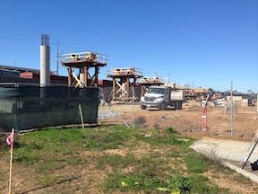
Work has started on the bridge that will connect Curtis Village to Sacramento City College over the Union Pacific railroad right-of-way. The bridge supports on the Curtis Village side have been installed. I did not see any signs of work yet on the section over the tracks nor on the west side at the light rail station and campus. The bridge will be usable by bicyclists, though I am not sure whether the design really addresses bicyclists. The paucity of east-west routes over the rail and light rail corridor means that both bicyclists and walkers have rather unpleasant routes to choose from, so this will be a great improvement. The Sutterville Road bridge, though it has sidewalks and even a narrow bike lane, is a very unpleasant place to be due to the high speed traffic and poor visibility.
California Walks, the statewide advocacy group, is hosted the Best Foot Forward Summit in Oakland on November 8th & 9th. I’m thinking of attending, but am unsure how exactly to make use of the summit to support efforts in the Sacramento region. If a critical mass of people from Sacramento attended, then we could have very useful discussions at the summit, and come to a consensus about how we can use the experience to move things forward here. However, there are only four people from the region registered at the moment. On the other hand, those who do attend could bring back a summary and skills for working on our regional issues, and share them locally with others. At the moment, it does not appear that WALKSacramento has the capacity to implement either of these ideas. But I’m asking that every reader here will consider the opportunity, and then share what they think, either by commenting here on the blog or by responding to the @GetAroundSac tweet and using the hash tag #BestFootForwardSummit.
What we know is that the transportation agencies in the region will move at a snail’s pace to improve walkability and livability, unless we exert strong public pressure on them. In fact, I believe that the harm they do will continue to outweigh the good they do, for some while, as they cling to outmoded ways of thinking and outmoded views of the kind of place that resident want. It will take a transformative experience to get advocates fired up and moving forward, together. I’m not sure if this is that experience, but I’d like to know what you think.
I am not minimizing the work of WALKSacramento and other advocates that have made a difference, particularly in the lower income South Sacramento area. This is all good work, and the priorities identified by community participants reflect the changing needs and desires of the region, but it is a drop in the bucket of what needs to take place.
Strong Towns issued a challenge to document your walk to the grocery store. Here is my contribution.
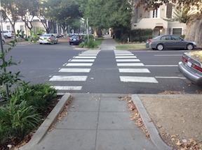
N Street, nice crosswalk, rude drivers
Grocery Outlet: One-and-a-half blocks. Out the apartment complex gate, through the alley, along and then across a quiet residential street (17th), across a two-lane one-way traffic sewer (N), and a block to the store. There are good sidewalks the entire way. Both crosswalks are clearly marked. The traffic on the larger street rarely yields to pedestrians, though that is the law in California, but most of the time it is not a long wait for a gap. I visit this store 2-3 times per week, almost always walking and carrying one large bag
Safeway: Nine blocks, 0.5 miles. Good sidewalks, nice streets, two semi-traffic sewer one-way streets (P, Q, same story, drivers seldom yield but gaps are available), one block without sidewalks but on a low traffic street (R). Sometimes I walk, sometimes I ride.
Sacramento Natural Foods Coop: 1.4 miles. Good sidewalks, mostly nice streets, several one-way traffic sewers (P,Q, 19th, 22nd, 29th, 30th). I occasionally walk this, but most often ride. I could take light rail, with a two block walk on both ends, but I seldom do. Depending on route, I can have quiet streets and/or bike lanes most of the way.
Trader Joes: 2.5 miles. Good sidewalks, mostly nice streets, two more traffic sewers than above. I have walked this, but rarely. I can take light rail, and sometimes do, two blocks walking on one end and three blocks on the other end. Mostly, I ride. Quiet streets part of the way (M Street, the closest we have to a bicycle boulevard), bike lanes available but on the less pleasant streets.
You might think, well how lucky to live close to a store, but luck has nothing to do with it. I chose this place to live primarily for its proximity to grocery stores. Other considerations were tree lined streets, close-by coffee shops, restaurants, bars, bike shops, breweries, etc. Walk score is 86, and yes, I did look at it before I moved here.
I have a bag on my bike that is perfect for carrying groceries, and I can carry quite a bit of weight that way. I am also willing to carry quite a bit of groceries when walking. I prefer to go to the store more frequently so that I can have more fresh food. No family, I’m just shopping for myself.
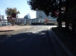
I Street entrance to Old Sacramento, from Envision Sacramento
The topic uses the photo at right to illustrate the question. What you can’t see in the photo is that behind the photographer and across 3rd Street (to the left), pedestrian access is on the south side, but to the west, it is on the north side.
Comments include a number about the aesthetics of this entrance to Old Sacramento, including the having a dark freeway under crossing as the main route into the one of the highlights of Sacramento, with poor signing for motor vehicle drivers, bicyclists, and pedestrians. A surprising (to me) number of comments, though, were about the transportation aspects, that it is really not safe for bicyclists or pedestrians to use this entrance, even if they know it is there, and the paucity of other options. I think it is clear that the commenters agreed that the way in which Interstate 5 severed the connections between downtown and Old Sacramento is a major issue.
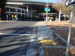
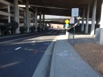
A gallery of photos shows some of the specific problems at this location.
These photos are of the I Street entrance to Old Sacramento, showing various problems and hazards that exist for pedestrians and bicyclists at this location. The crosswalks here are not really safe. All sorts of signing has been installed to try to make them safe, but that is a poor substitute for correct design. The […]
The City of Sacramento and CADA held a community meeting on November 23 on the R Street Phase III Streetscape project, presenting design alternatives for the section of R Street between 13th and 16th streets. Phase I is the already completed portion between 10th and 13th, and Phase II is the upcoming portion between 16th and 18th. Three alternatives were presented for each of the three blocks, basically representing three different levels of traffic calming and devotion of right-of-way width to pedestrians rather than vehicles. Alternative three for each block includes curb extensions or bulb-outs at most corners. All the alternatives include wider sidewalks.
I am glad to see the city moving forward on these improvements, with the already completed Phase I making a huge difference to the usability and appearance of the street. Though the most economically vibrant portion of the street currently is this section from 13th to 16th, it will unfortunately be the last to be completed.