With this post, I’ve added a new category to my blog: re-gridding Sacramento. I’ll have more to say about that category, and many more posts, in the near future.
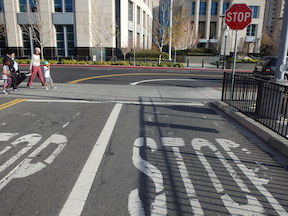
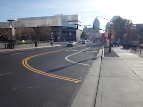
Sac Valley Station exit, forced right5th St to I St, forced right turn
Let’s say one was driving and wanted to leave the Sacramento Valley Station (Amtrak and Capitol Corridor) to head southbound or eastbound. Tough luck. The exit at the east end of the parking lot forces you to turn right, to the south, onto 5th Street. I often see people turning across the double yellow line to go northbound on 5th Street, and to be honest, I don’t blame them, because this is the logical though illegal way to go south or east.
SACOG in the 2013 funding round allocated $9M to the Riverfront Reconnection project in the City of Sacramento. This phase extends 2nd Street from Old Sacramento to Capitol Mall, providing an easier access to Old Sacramento, and also adds sidewalks to O Street and improves sidewalks and bike lanes on Capitol Mall between 3rd Street and the Tower Bridge. The overall purpose is to create or restore connections between downtown Sacramento and Old Sacramento which were severed by Interstate 5.
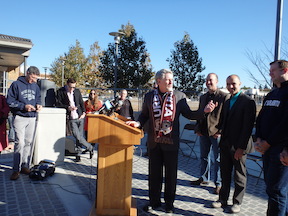
Steve Cohn, Christopher Cabaldon, Steve Hansen, and other streetcar supporters
The Downtown/Riverfront Streetcar is moving forward. Today there was a demonstration of a Siemens S70 streetcar (made in Sacramento, but unfortunately on its way to Atlanta) at the Township 9 (Richards & 7th St) SacRT light rail station. Mayor Christopher Cabaldon (West Sacramento), Councilmember Steve Cohn (Sacramento) and several others spoke about the future of the streetcar linking West Sacramento and downtown/midtown Sacramento. After the speeches, there was a ride downtown and back so people could see the streetcar in action, and informally discuss the project on the way.
Siemens S70 streetcar at Township 9 station
Yesterday the SACOG (Sacramento Area Council of Governments) board allocated $5M in funding for phase 1 of the project, which is the initial planning, route selection, and environmental review of the system. SACOG is one of the project partners, along with the City of Sacramento, the City of West Sacramento, Sacramento Regional Transit (SacRT), and Yolo County Transit (Yolobus). The remainder of the project costs totaling $12.3M are being provided by the partners. (Details of the SACOG application are at the bottom.)
A reference to the Abogo calculator from the Center for Neighborhood Technology (CNT) in Kaid Benfield’s post today sent me there. Abogo is based on CNT’s Housing + Transportation Affordability Index, which I was familiar with, so I’m surprised I’d not noticed Abogo, but now I have.
At right is the calculator result for where I live. Hard to read the legend, but the dark green is less than $1000 per month. Of course I spend a good deal less, $100 for a transit pass plus about $20 a month for bicycle maintenance, but the numbers seem reasonable for others who live in downtown/midtown.
I stumbled across a twitter feed about a week ago, and it is filling up my twitter timeline, by far the busiest thing I follow. It is Sac Traffic, which is a CHP feed of traffic alerts in the Sacramento region, at @sactraffic.
As a bicycle rider and walker I’m hyper aware of the risk out on the roadway, and assumed there were more incidents than I was aware of, but I had no idea there were so many in the Sacramento region. I follow the Sacto911 blog on the SacBee for the purpose of tracking carnage to pedestrians and bicyclists. It includes traffic and other crime, but it generally only has a few to no incidents per day. I’ve long suspected there were more, but never had any solid information.
In the last there days, Monday through Wednesday, at least four people died when struck by car drivers, and two others were injured. I know that the Sacramento Bee does not report all pedestrian and bicyclist fatalities and injuries, so there may have been more in the region, but this is an incredible level of slaughter.
The better of these articles describe the outcome and location in a factual manner. The poorer ones place the blame on the victim. This victim blaming is aided and abetted by the law enforcement officers who make the assumption that either a) it was a “tragic accident” that could not have been prevented or b) the driver was not drunk and remained at the scene, so clearly it is the pedestrian or bicyclist’s fault. Both are nonsensical statements and ideas.
As though I need something else to do, I have started another blog called Caltrans Watch, following a conversation with Jim Brown in which we realized that someone needs to be calling Caltrans to account on its sprawl-inducing and livability-killing approach to transportation. Please take a look and make suggestions for improving it, hopefully with your own contributions. There is a Twitter handle to go with it, @CaltransWatch.
William Burg started a wonderful conversation on Facebook about removing Business 80 from B Street to Hwy 50, returning the traffic to surface streets. The post is now up to 115 comments, and still going after two weeks. I believe that you have to be a member of Facebook to view this thread, but don’t need to be friends with William Burg (though you should). I agree with Jared that this topic should be amplified for Sacramento Press.
Some people think that this is crazy thinking, it will never happen. I think it will. Why? Not because it is a good idea, though it is, but because we will not be able to continue to keep these freeways open and in decent condition with future transportation funding. Caltrans and others have just spent or are spending $202 million on Hwy 50, basically just to keep in it usable condition. Not to improve it in any significant way, but just to keep it working. Where is the money going to come from to maintain Hwy 50, Interstate 80, Interstate 5, and Business 80 (Capital City Expressway)?
non-functioning water fountain at Sunrise light rail station
On Wednesday evening, I rode from Woodside K-8 School in Citrus Heights to the Sunrise SacRT light rail station, and then caught light rail home. As I passed Sunflower in Fair Oaks, I thought of stopping for a drink of water, but decided to just head on down the hill to the drinking fountain on the north side of the red Fair Oaks bridge. It was not working, covered with plastic. I continued on to the Sunrise station, where both water fountains are not working. I suspect these have not been working for years, they look abandoned. By this time, I was pretty darn thirsty, and the long wait in the evening for the next light rail train was not pleasant. Even if I’d wanted to go to a convenience store for something to drink, there aren’t any close to that station.
The lead article this week in the Sacramento News & Review is Sacramento’s report card. I can’t resist getting in on the fun.
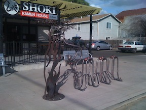
The article covers bicycle transportation in the “On two wheels” paragraph, and does it pretty well, giving a C grade. I’d add that art bike racks can be fun if they are also functional. The dragon at Shoki Ramen House and the bottle openers at New Helvetia Brewing are good examples. I think bicycling really works pretty well in the central city and some of east Sacramento, with people getting along in sharing the road most of the time. The further out you go, though, the worse things are, with belligerent drivers traveling at high speeds. I’d give central city a B and the far suburbs an D-. Does this average to a C?