Freeport Blvd to council today

The Freeport Blvd Transportation Plan is on the Sacramento City Council Agenda today. I failed to notice this, and submitted my comment late, so will have to attend in person or on Zoom. The item is on the consent calendar, so it is particularly important that people comment on the item so that the city recognizes there is significant opposition. You might also contact your council member to request that they remove the item (#6) from the consent calendar.

You may read my previous blog posts at https://gettingaroundsac.blog/category/city-of-sacramento/freeport-blvd/. You may read other’s comments on the agenda item at https://sacramento.granicusideas.com/meetings/4599-5pm-city-council-closed-session-begins-at-4-00-pm-updated-02-slash-21-slash-2023-at-1-30-p-dot-m/agenda_items/63eeca6df2b670376d010289-6-freeport-boulevard-transportation-plan-final-dr

H St bicycle fixes

H Street is commonly used by bicyclists leaving Sacramento Valley Station, and others as well. It has decent bicycle facilities except for some gaps.

H Street has a bike lane on the south side from 5th Street to 16th St, except one block, 7th Street to 8th Street. There is absolutely no reason for this gap. This is the section between the Sacramento County Administration Building on the south and a decked parking garage on the north. The parking seems to be there for the convenience of people working in the building, as there does not seem to be turnover of the parking spots. There is ample parking in the garage. This parking should be removed and a bike lane painted IMMEDIATELY. No excuses. A common quote in the bicyclist community is “sharrows are bullshit”, and this is the case here, where the city has preferenced motor vehicle drivers over bicyclist safety.

H St parking and sharrows from 7th St to 8th St

There is a bike lane on the north side between 7th Street and 13th Street. Bike lanes on the left side of one-way streets are much less used than right side bike lanes, but are useful.

Read More »

M Street to Hornet Tunnel

I have long been planning to write about the extremely poor bicyclist facilities from M Street to Hornet Tunnel, which is a major access point for Sac State.

M Street is a major east-west bicycle route, with some but not all of it marked as a bicycle route. If the city used the bicycle boulevard designation, it would be designated a bicycle boulevard. M Street forms an uncontrolled T-intersection with 62nd Street, which leads a short way left to a signalized T-intersection with Elvas Ave.

Hornet Tunnel is a major access point to Sac State campus, probably second only to the Guy West bridge access on the north side.

The map below shows M Street, 62nd Street, Elvas Ave, and Hornet Tunnel, as it exists.

The route from M Street to Hornet Tunnel is heavily used by bicyclists, both students and people passing through to the American River Parkway paths. It would be much more heavily used if it were safe, but it is not.

Eastbound to campus, one must cross over four lanes somewhere between 62nd Street and the median along Elvas Ave, and then ride on the wrong side of the street to reach Hornet Tunnel. Westbound, it is not bad, only having to merge over the northbound lanes to a dedicated left turn lane to 62nd Street. The signal here is surprisingly responsive to bicyclists, so the wait is usually short.

At the 62nd Street & Elvas Ave intersection, Elvas is 62 feet wide, 70 feet with sidewalks. There are shoulder stripes setting off unofficial parking, one southbound lane, one center turn lane, and two northbound lanes. At 64th Ave, Elvas is 68 feet wide, 76 feet with sideewalks. At Hornet Tunnel, Elvas is 63 feet wide, 77 feet with sidewalks, with two northbound lanes and three southbound lanes, two of which are dedicated right turn lanes to 65th Street. Elvas was formerly wider at Hornet Tunnel, but some sidewalk was added there to ease crowding at the tunnel entrance/exit. Given the city-preferred, though unnecessarily wide 11 foot travel lanes, there is room for six lanes of traffic here! That means there is ample room for bicycle facilities. But there are none present.

Some bicyclists take the striped shoulders to be bike lanes, but they are not. The city’s 2018 Bikeway Master Plan shows this section of Elvas between 65th Street and Hornet Tunnel as a Class 2 (on-street) bike lane, but this is false. It is not indicated as such with either pavement markings or signage. Though the shoulder stripe southbound has the dashed marking often used to indicate a bike lane approaching an intersection, this is a fake. It is NOT a bike lane. People park along this stretch, so even if it were a bike lane, it would not be safe nor meet minimal standards for a bike lane.

Solutions

What street redesign and reallocation would make is safer for bicyclists?

First, for northbound bicyclists, there should be a separated bikeway on the right side of the street. Along this section, there are four driveways and a stretch of street-oriented perpendicular parking (where vehicles enter directly into parking spaces from the street). There is a section of 270 feet with no existing buildings. Though there could be parking protected bikeway along here, I don’t think the parking is even needed. Instead, this is probably a good location for a curb separated bikeway, with hard curb to prevent encroachment on bicyclists. The curb would be cut only for driveways which are currently in use. The existing parking along this stretch is used mostly by students to avoid paying on-campus parking fees. All the businesses have onsite parking. The one business that might reasonably need short-term parking on Elvas is The Mill coffee shop. Separated bikeways work best with long stretches without driveways, but one here is workable.

Southbound is more complicated. If there were a bike lane or separated bikeway on the southbound side of Elvas, bicyclists would still need to cross to Hornet Tunnel, at a location where there is currently no way to do so. I see three options:

  1. First, have bicyclists ride south to the existing 65th Street & Elvas Ave intersection, and use the crosswalk on the north side to cross over and then go north to the tunnel. This is very awkward, out of the way, and encourages bicyclists to use a crosswalk, which is not illegal but poor practice.
  2. Second is to create a two-way separated bikeway (often called a cycletrack) on the east side of Elvas, from 62nd Street to the tunnel. A separate bicyclist signal phase would need to be created for northbound bicyclists to cross to 62nd Street, and southbound bicyclists to cross to the east side of Elvas Ave. An advantage to this solution is that parking on the west side of Elvas does not need to be changed, though it can be reasonably argued that there should be at least a regular bike lane here for bicyclists who are not going to the tunnel, but continuing south on Elvas or south on 65th Street.
  3. Third, have bicyclists continue southbound on Elvas, but create a clear zone for crossing to the tunnel by signalization. Northbound motor vehicles would be held by the existing signal at the intersection of 65th Street and Elvas Ave, while southbound motor vehicles would be held at a stop line just north of the tunnel by new signal heads. Bicyclists would cross to the tunnel during the red phase. There would need to be queuing area for southbound bicyclists, since they would exceed the stacking capacity of the bike lane during busy times. This option probably slows motor vehicle throughput more than the other options.

No matter which solution, the sidewalks along Elvas Ave should be repaired and widened, and street trees should be planted. And of course the street needs to be repaved.

Below is a Streetsmix diagram showing one possible configuration (looking north) with a two-way separated bikeway (cycletrack) on the east side, along with wider sidewalks and trees in a planing strip, and a southbound regular bike lane. And yes, all this fits in the existing over-wide Elvas Ave right-of-way!

SacCity should remove crossing at alleys prohibition

City of Sacramento code prohibits pedestrians from crossing streets at alleys.

10.20.030 Crossing at alleys.
     No pedestrian shall cross a through street at an intersection with an alley except within a marked crosswalk. (Prior code § 25.03.052)

https://library.qcode.us/lib/sacramento_ca/pub/city_code/item/title_10-chapter_10_20-10_20_030

While this code has always been an attempt to prioritize motor vehicle drivers over people walking, it is becoming increasing problematic as housing and businesses are now located along alleyways in the central city. ADUs and lot split housing are often accessed through alleys and not from the street. This code makes it so that anyone living or doing business in an alley must go out of the way to cross the street, and it prohibits people who just want to walk alleys to avoid busy streets.

The code should be excised.

slip lanes of death

Additional information added below.

Today I wandered around the edges of Sac State, looking at some of the access points. But the worst of the worst is this slip lane from 65th Street northbound to Folsom Blvd eastbound. More on access soon.

slip lane 65th St north to Folsom east

Is there a stop sign? No. Is there a signal to stop motor vehicle drivers when the crosswalk is being used, or the bike lane on Folsom? No. Is there a yield to pedestrians sign? No. Is there paint on the ground? Yes. It is well known, among traffic engineers, if no one else, that the word ‘yield’ painted on the ground slows drivers to a safe speed. This is bullshit.

The city recently did ADA ramp work on this corner. They could have fixed the issue, but did not.

This is the kind of transportation infrastructure the City of Sacramento builds to preference the convenience and time-saving of drivers over the lives of people walking and bicycling. This is criminal negligence. The next time someone is killed or injured here, I would be happy to testify that the city was aware of this hazard and chose not to do anything about it. Criminal negligence, as I said.

Additional Information

Solutions

  1. Install stop signs at every slip lane.
  2. Do NOT install signalization since this is an expensive alternative and would be wasted when the slip lane is removed.
  3. Place a prohibition on slip lanes in city code except under rare and defined circumstances. This would be where the crossing roadway presents an angle less than 75 degrees, a sharper than right angle turn. This skewed intersection does not quite meet that criteria, but even if it did, the slip lane as constructed is hazardous.
  4. Develop a program to close all slip lanes in the city within one year.
  5. Develop a program to replace the closed slip lanes with sidewalks, planting strips, or other useful infrastructure within five years.

reallocate N St to a separated bikeway

Note: Added information on proposed streetcar alignment below.

N Street in downtown Sacramento, from 3rd Street to 15th Street, is a three lane street with parking on both sides. There are no bicycle facilities. For part of the stretch, from 8th Street to 15th St, the sidewalk on the north side is a designated bike route, and is signed as such. Currently, this route alongside Capitol Park is closed due to annex construction, and not alternative has been provided. The city has made the choice to offer nearly unlimited capacity for motor vehicle drivers, but to dump walkers and bicyclists onto the same sidewalk. Some of the time this sharing works, but not when it is at all busy with either walkers or bicyclists.

N Street does not need, and has never needed, three motor vehicle lanes. Since the pandemic, the street is empty most of the day, with very short periods of heavier traffic, but it is never congested. Even before the pandemic, there was only about 20 minutes a weekday when the street could have, perhaps, be considered congested. Frequent construction projects, both before and during the pandemic, have narrowed N Street from three lanes to two, and even to one for shorter periods of time. When there was one lane, traffic was slow (a good thing!) but never really backed up.

The gallery of photos below was taken today, admittedly mid-day when there is almost no traffic at all, but ‘rush hour’ would not look much different. Motor vehicle traffic has come back to pre-pandemic levels on some city streets, but has not on N Street, and it is very unlikely that it ever will.

How should N Street right-of-way be reallocated? By installation of a parking protected separated bikeway on the north (left) side of the street, from 3rd Street to 15th Street. Separated bikeway is the official term, though protected bike lane or cycletrack are common alternative terms. Though in general left side or right side each have advantages and disadvantages, in this case left side (north side) works best because the of long stretch free of driveways on the Capitol Park side, from 10th Street to 15th Street.

Sacramento already has parking protected separated bikeways on P Street, Q Street, 10th Street, and J Street, though J Street in particular is a weak implementation. The NACTO diagram shows a high quality parking protected separated bikeway with a concrete curb, which retains all the benefits and safety even when there are no parked cars. For sections with driveways, protection with vertical delineators may be appropriate.

NACTO diagram one-way cycletrack with curb

The number of driveways in each block between intersections is:

  • 3rd-4th: one, parking garage
  • 4th-5th: zero
  • 5th-7th: two, parking garage, gated driveway
  • 7th-8th: zero
  • 8th-9th: one
  • 9th-10th: two, rarely used
  • 10th-15th: none

The advantages of this reallocation:

  • greatly reduces conflict between walkers and bicyclists on the north sidewalk between 8th St and 15th St
  • provides a safe east-west bicycle route
  • reallocates unneeded roadway width from motor vehicles to bicyclists

The city’s Central City Mobility Project will add 62 blocks of separated bikeways to the downtown area. All of these projects are great. But N Street is not among them. The lane reduction on I St, shown in purple, is particularly great. N Street would benefit from the same. Lane reductions not only slow motor vehicle traffic, but can shorten crossing distances for people walking. Three (or more) lanes in a direction are never safe, and never appropriate in an urban area. All of the three lane roadways in the city should be reallocated to other uses, and reduced to two lanes.

These type of projects are often called road diets, but I don’t like that term. The road is not on a diet, it is just being reallocated from unnecessary or unwanted motor vehicle capacity to more useful purposes such as walking, bicycling, or dining.

Read More »

support SacATC status on walking/biking (now!)

I encourage you to support the Sacramento Active Transportation Commission’s (SacATC) sending the Status of Walking/Biking committee report to city council. The report is on the agenda for SacATC on this Thursday, 6:00PM to about 8:00PM.

The report is the first attempt since the early days of the SacATC to actually address transportation policy. The SacATC has unfortunately become a rubber stamp for city grant applications, and has not delved into policy since the early days when an update of the city’s Bicycle Master Plan being completed, and the ATC was able to make some improvements to that. The commission was formed to advise council on policy (it is NOT advisory to staff, but to the council), but has not done so. Now is the time, and this status report should be supported because it finally starts to address policy.

The status report includes nine recommendations:

  1. Increase Funding for Active Transportation
  2. Expand Speed Management Program
  3. Develop a Citywide Safe Routes to School Program
  4. Finalize the Construction Detour Policy
  5. Develop an ATC Dashboard
  6. Create a Sacramento Quick-Build Bikeways Program
  7. Pilot an Electric Bike Library & Promote E-Bike Incentives
  8. Increase Bike Parking
  9. Re-establish Slow & Active Streets

I’m sure you can think of many other recommendations that might be made, but this is a great start. If the council pays attention to these recommendations, and takes action to create and fund programs, the status of walking and bicycling will have improved by next year, and more items can be added.

You an express your support in several ways:

Consult the agenda for more detail on making public comment. It used to be possible to submit email to the city clerk, but this option is no longer mentioned.

bike left turn Carlson Dr to H St

I was at a meeting last evening with transportation advocates when the subject of the turn left from Carlson Drive to H Street came up. Most people expressed discomfort about this turn, and most of the people were also experienced and skilled bicyclists. They felt that left turning motor vehicles, which go at the same time as left turning bicyclists, would encroach on the dashed green lane and hit bicyclists. They were also uncomfortable turning across the straight through lane, as they had seen people run this red light. This is a critical intersection and area for bicyclists, as it is one of four main routes onto and off the Sacramento State campus for bicyclists.

So today I went to take a look. I have not written about this intersection before, but two articles are of interest: SABA https://sacbike.org/carlson-corridor/ and City of Sacramento https://www.cityofsacramento.org/Public-Works/Engineering-Services/Projects/Completed-Projects/Carlson-Drive-Improvements.

So far as I know, this was the first use of green paint, and the first use of a bicycle signal head in the city. The installation was intended to be innovative, and it was, for its time, in Sacramento, but it hasn’t stood up to the test of time.

Here is what it looks like from above. As you can see, it is a complicated intersection with several features intended to ease and speed motor vehicles. The city attempted to make the intersection safer without really changing it at all, beyond the green paint. Green paint helps communicate, but it does not protect in any way, and it has no legal meaning under California Vehicle Code or city code.

Carlson Dr - H St intersection aerial
Carlson Dr – H St intersection aerial

The two photos below show the setting of the left turn. The bicycle lane on the right side of the street leads to a dashed (skip) green lane turning through the intersection. The bike lane stop line is somewhat in front of the motor vehicle stop line, and there is a button to trigger the bicycle signal. The bicycle signal face is mounted to the right of the motor vehicle signal face, and there are two, before the intersection and on the far side.

bicyclist pressing the button to trigger the bicycle signal
bicyclist turning left from Carlson to H St; bicycle signal face green

I was there at a low traffic (motor vehicles and bicyclists) time of day and was unable to capture a bicyclist and motor vehicle adjacent to each other on the turn.

I have to say that I was not uncomfortable with the left hand turn. I’m a strong bicyclist and good at anticipating and mitigating for driver misbehavior. But I’m not the person bicycle facilities should be designed and built for. They need to be comfortable and legible (understandable) for any bicyclist, of any age and skill level, including Sac State students who seem to be the majority of the bicyclists here. This left turn is not.

There has been only one reported bicyclist injury crashes at this intersection since the green paint was put in (as of December 2020), and one in the 6-1/2 years before, so it is not a high injury intersection. But intersections like this discourage bicyclists, and so fewer people are willing to bicycle here. The poor quality of most of the access points to the Sac State campus probably in large part explains why the school has a much lower bicycling rate than most universities.

I don’t have a ready solution for fixing this intersection so that it is safe and comfortable (low stress) for bicyclists. But I do believe it is the city’s responsibility to study it, design a safe and welcoming intersection, and install it.

Freeport Blvd as a failure of vision and possibility

Another post on the Freeport Blvd Transportation Plan. See the category Freeport Blvd for other posts.

It should be obvious, if you have been reading, that the City of Sacramento’s Freeport Blvd Transportation Plan is a failure of vision and possibility. How so?

The city removes from all planning efforts the possibility of reducing speed limits on streets that are reconstructed, usually complete streets projects. Whatever the speed limit is before the project will be the speed limit after the project. I’ve written about this before: lower speed limits on complete streets in Sac. I get that changing posted speed limits without changing roadway design has only limited effect in lowering speeds. But we are talking about reconstructing streets, the very design changes that are necessary to effectively lower motor vehicle speeds. Yet the city refuses to consider lowering speed limits when planning reconstructed roadways. Posted speed is like a rachet, it can only increase but never decrease. Some planners and engineers go so far as to claim that the law prevents lowering of speed limits on reconstructed streets. That is a lie.

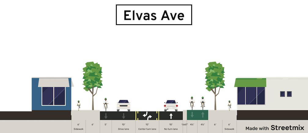
The city also refuses to consider lane reductions (also called road diets, roadway reallocation, or right-sizing) when average daily traffic counts (ADT) are above certain thresholds. It will not consider that ADT is above what it should be because the city earlier widened roadways and induced the travel that is now resulting in high ADT. Again, lane counts are like a rachet that goes only one direction. You can increase lanes, but you can’t decrease lanes, except in situations where the roadway is so obviously overbuilt that it would be ridiculous to suggest maintaining that number of lanes.

The city has a responsibility to reduce vehicle miles traveled (VMT) in the city, under state law, under SACOG guidance, and its own policy in the Mayor Climate Change Commission Report and Climate Emergency declaration. Yet in transportation planning, the city seems to be fully committed to maintaining the current levels of VMT by ensuring that the current levels of traffic are not reduced. This is climate arson.

Community input to the Freeport Blvd planning process provided high priorities: safety, economic vitality, and walkability. Yet the plan maintains motor vehicle capacity, ensuring that the community priorities will be only partially met. This is not a compromise between drivers and walkers and bicyclists. It is throwing crumbs to the walkers and bicyclists so that drivers may eat nearly the entire cake.

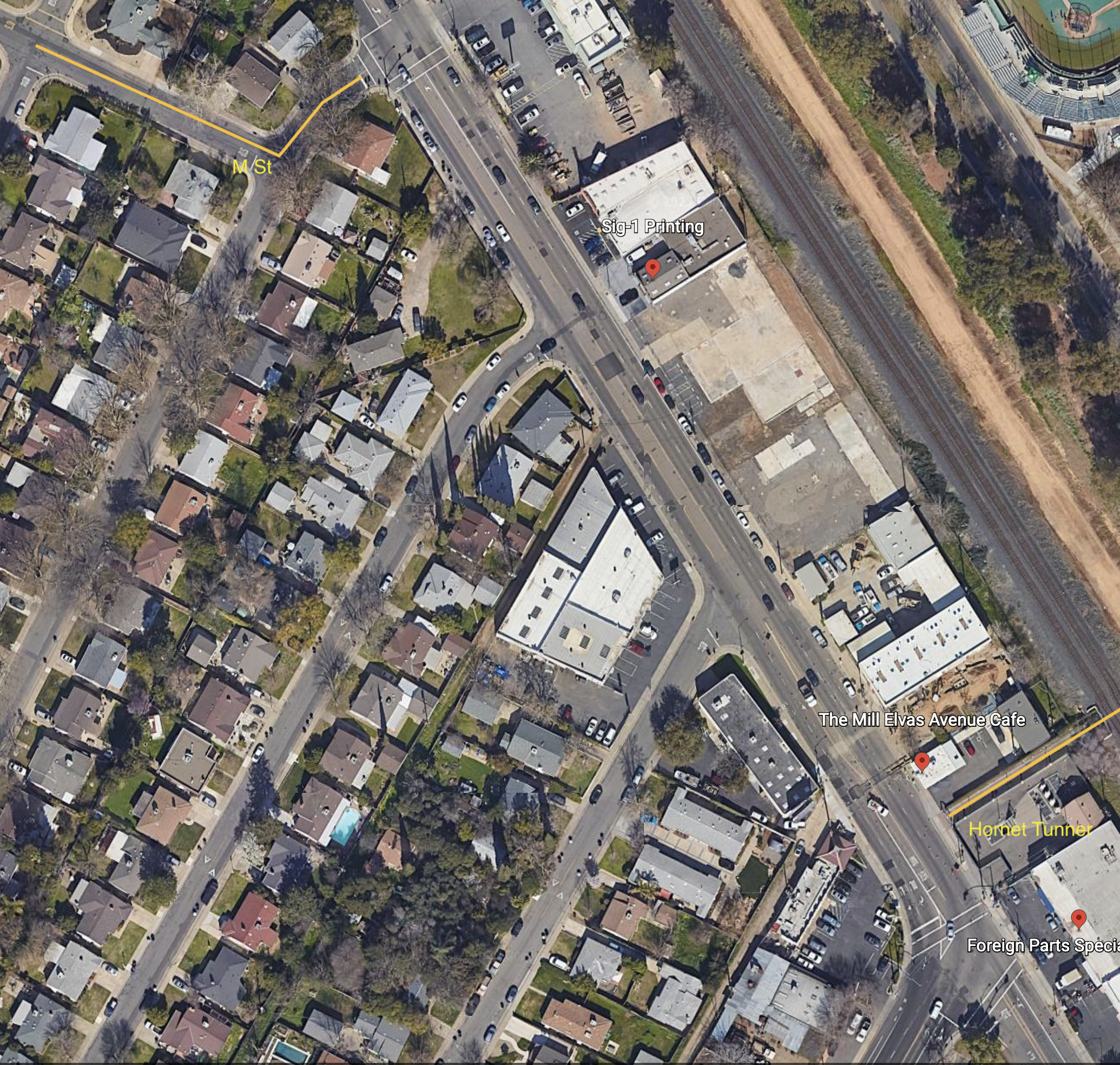
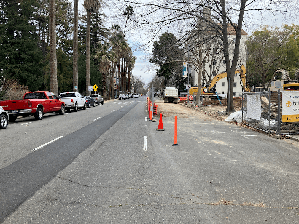
Freeport Blvd, today, is a suburban form. Uninviting streets, hostile walking and bicycling, many small businesses in strip malls and a few big box stores (some of them closed or failing). The built environment is an artifact of the time and way in which Sacramento grew in this direction. It is a fact. But the city, in its transportation plan, makes no effort to change or mitigate that fact. In no way does it even suggest transformation to a more vibrant and interesting place. At the simplest level, it just adds bike lanes and changes nothing else. I’m not against bike lanes, and certainly not against separated (protected) bikeways, but they are not transformative. What would be transformative is shifting Freeport towards a walking-first transportation corridor, a destination for people who live there and people who travel to there.

The city intends to add a number of new crosswalks to the corridor. That is good news, as distances between safe crossings are too great. The problem is, most of these will require extensive signalization to protect the people crossing there, because speed limits are such that a person hit by a motor vehicle will be seriously injured or killed. Lower speed limits, not just posted but enforced by design, would allow much less expensive crossings. Money matters. The city will put very little of its own funds toward these changes, depending mostly on regional, state and federal funds, which will always be too little and too slow.

This plan is only the first step in changing the roadway. Grants will be solicited for major project work. A few critical locations will be improved in the near term. But the plan as a whole is decades away from completion, particularly if the probably unnecessary section south of 35th St is included. The city has done pretty well obtaining grants for complete streets, but with an entire city full of streets needing improvement, Freeport Blvd can’t be and won’t be the only priority. Once the plan projects are complete, the street won’t likely be changed for 30 years. So 50 years from now, more or less, the roadway will look like what the city has planned today. Will it meet the needs of citizens at that time? Very, very unlikely. In the future, VMT will be and must be much lower than it is now. A much higher percentage of trips will be made by walking and bicycling. The built environment will densify, with more small businesses, though some stretches won’t make it and will fail. That’s OK. Properties with failed businesses are good candidates for infill housing, which will support those businesses remaining. But housing along a dangerous traffic sewer, as Freeport Blvd currently is and will largely remain under the city plan, is a disservice to everyone who lives there. Who wants to live on a busy arterials stroad, where you can’t let your kids outside because the risk of traffic violence is too great, and the air hazardous to breathe, and the noise of traffic is a constant psychological and health danger? Riding to the grocery store may be slightly more pleasant and somewhat more safe, but many people still won’t want to because they aren’t comfortable with regular bike lanes beside high speed traffic, and complicated intersections. People won’t want to walk during the summer because the city failed to plan for and install trees along the sidewalks.

Enough said for now. I may write some more or post others if people point out important issues that I have not addressed. Otherwise, the next post will be just before the plan goes to city council, in hopes that citizens will urge the council to reject this plan as too flawed for use. I was very disappointed that the City of Sacramento Active Transportation Commission rubber-stamped the plan and passed it along to council, but that is water under the bridge.

The city can do better, but only if a significant number of citizens press their council members to set a higher standard for transportation planning than is exhibited in the final draft plan.