The white line stripes that were added to the two blocks of P Street protected bikeway, 19th Street to 17th Street, are an attempt to keep leaf piles and trash cans out of the bikeway. I noted the added white stripes in Central City Mobility update #27, but wasn’t sure why they were added. The wording was added later. I have not yet observed this location on either a trash pickup day, or now that there are a lot more leaf piles. I have not seen the striping and marking on other blocks of the new bikeways, so this may be a pilot to see if it works. The practice of putting leaf piles in the regular Class 2 bike lanes in common, and the city has made no effort to reduce this practice.
The Sacramento City Council will hear tonight (Tuesday, November 28, 2023, 5:00PM) on a recommendation to increase the floor area ratio (FAR) from 1 to 2 in areas within a half mile of frequent transit, and other improvements. The Missing Middle Housing program is part of the 2040 General Plan update. In October, staff brought missing middle housing to the council. Housing advocates led by House Sacramento suggested several improvements, and several council members spoke strongly in favor of improvements. See Sac missing middle housing project for background. So at the council meeting tonight, staff will be back with some of the recommended improvements. The documents are here: body of the staff report; table of public comments (the comments account for most of the size of the document, so the body will download much faster).
Public support for improved missing middle housing program policies and areas is critical to ensure that it will end up strong in the general plan. Though people opposed to better housing availability (NIMBYs) have so far not shown up to speak against it, they have been using their political power behind the scenes to ensure that housing remains scarce (which increases their own property values) and that their neighborhood does not change nor include people who have been excluded from housing and opportunity. Of course these Missing Middle Housing program elements will only take effect if they are not weakened when the 2040 General Plan is adopted, perhaps late next year. So housing advocates will need to remain vigilant.
Please see the House Sacramento Take Action page for information about providing public comment on the issue, and suggestions for your comments.
I believe that the public should support these changes. The general plan could be even better, by removing zoning completely, but this represents a huge improvement over both existing conditions and the earlier proposal.
Floor area ratio (FAR) changed from 1 to 2 for all areas within a half mile of frequent transit service (which means if and when areas get better transit service, they can be similarly be allows greater housing density and variety). See map below (pdf). While the area changed is not huge, it represents a huge opportunity for more housing along light rail and SacRT bus route 1 along Stockton.
The cap on dwelling per parcel are removed. Use of FAR will provide the appropriate level of control without reference to number of units. The cap on dwelling is a continuation of the exclusionary housing policies of the past.
Creation of a sliding FAR scale. To be honest, I don’t quite understand this policy, but I trust to House Sacramento that it is useful.
I have written before about excess signals in the central city: too many traffic signals?. The fact that these exist is bad enough, but as part of the 5th Street conversion project, one-way to two-way, the city is replacing unnecessary old signals with very expensive and unnecessary new signals.
At 5th Street and S Street, a new signal is being installed. S Street is a low volume street that never needed and never should have had a traffic signal. A four-way stop sign, maybe, or maybe only stop signs for S Street. A fully signalized intersection, no way. There is nothing wrong with the existing signal for northbound traffic. Of course, a new signal is needed for southbound traffic. But the city is replacing northbound. Why?
Why is the city putting in a new signal here? Because there was one here before. If this intersection were studied for whether it needed a signal, the answer would be no. A warrant is a study indicating a need for a signal, as is simply explained at http://www.apsguide.org/chapter3_mutcd.cfm (this is much easier to read than the MUTCD). The 5th Street & S Street intersection does not meet any of these criteria. So, the city is putting in a new signal because they want to, not because it is necessary.
new and unnecessary signal at 5th St & S St
The current cost of a fully signalized intersection is $200K to $500K. Half a mil per. Your tax money. For intersections like 5th Street and P Street, a signal probably is necessary, particularly since the P Street and Q Street traffic sewers encourage high speeds.
It is likely that the signal at T Street is similarly unnecessary, however, T Street is busier than S Street, so might be justified by traffic volume. I’d like to see the city do a new traffic warrant study on this intersection. The city always uses warrants as an excuse for something it does not want to do, but seems to ignore these for things it wants to do. A typical traffic engineering misuse of MUTCD guidance.
The rubber speed bumps have finally been installed on most of the non-concrete turn wedges. These are marked by vertical delineators, as shown below. it is odd that most of these installations have both green K-71 vertical delineators in addition. These K-71s might have been installed temporarily, while waiting for the rubber speed bumps, and be removed later, or may be permanent. In some of the locations, the white vertical delineators have already been hit and bent by errant drivers. I have not visited all of the locations where the rubber speed bumps have been installed (or not), so don’t have any more information. More info about the rubber speed bumps is available from the vendor TreeTop Products.
turn wedge at 16th St & P St, with green K-71 delineators and rubber speed bumpsRead More »
“Missing Middle Housing (MMH) is a range of small multi-unit housing types that are similar in scale to a single-family house and are often found in walkable areas. This study focuses on duplexes, triplexes, fourplexes, ADUs, and bungalow courts. MMH types are ‘middle’ in form and scale between that of small single-family houses and larger apartment buildings, enabling them to blend into existing residential neighborhoods. With smaller units, MMH can provide housing at price points attainable to many middle-income households.”
If you would like to see what missing middle housing looks like, head to midtown Sacramento, where missing middle is mostly NOT missing. Midtown has a mix of building uses and housing types. There are corner grocery stores, single family houses, bungalow courts (cottage court, in the MMH documents), multi-unit apartments, and large apartment buildings, with clusters of commercial areas hosted small locally owned businesses.
Midtown was created before the city decided (along with most governments) that uses should be far separated, jobs downtown and housing in the far suburbs. It prohibited most of the kinds of buildings that exist today in midtown. Some of this was through exclusionary zoning, and some through parking mandates that made affordable housing almost impossible. Most, though not all, of midtown escaped the city and state’s urban renewal travesty of the 1960s and 1970s. The city and state replaced missing middle, and lower income, housing, and the people who lived there, with state buildings and parking lots throughout downtown Sacramento (west of 15th Street). But the urban renewal project had just bitten into the edge of midtown, to 17th Street, before urban renewal was stopped, and the housing that had been purchased and not yet torn down was transferred to Capitol Area Development Agency (CADA). And parking mandates were removed from the central city (midtown and downtown).
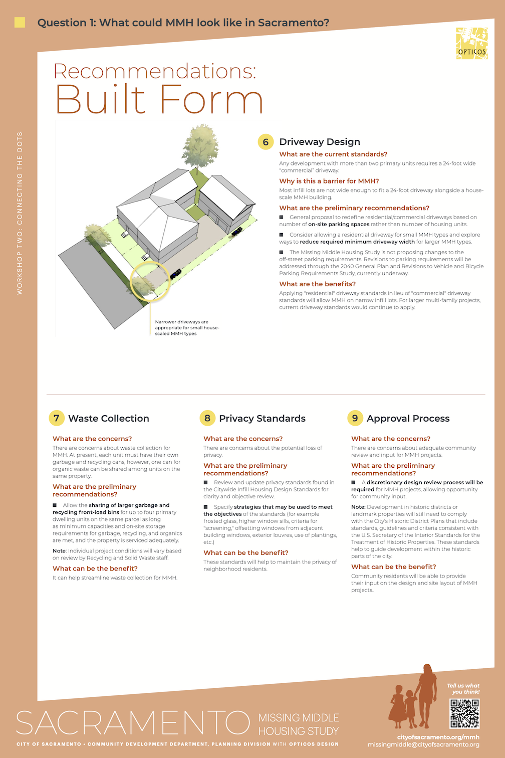
The Missing Middle Housing Project will become part of the 2020 General Plan update. Four reports will be produced, and the first two are done: MMH Informational Report, and MMH Attainability & Livability Analysis. The analysis was the topic in front of the city council on October 24. All the public comments were in favor of the concept, and requested strengthening the project by removing some of the remnants of the old zoning regime such as tiers matching existing zoning patterns, and unnecessary dwelling unit limits. Floor area ratio (FAR) should be the only built environment limit. The council was also very much in favor of a stronger program, and clearly favored removal of dwelling unit limits. All the attendees were pleased at the support of the council for a strong MMH plan.
My point of concern was recommendation 9, Approval Process – “A discretionary design review process will be required for MMH projects, allowing opportunity for community input.” in the staff presentation. This page is below, and pdf. This type of community review, where NIMBYs are able to kill housing of any density greater than current density, and housing for people of color and lower income, is what got us into this fix to begin with, it is largely the reason missing middle housing is missing. It included in the final proposal, this one item could potentially kill any new housing, by allowing the same exclusionary policies to continue.
City staff tried to clarify that design review would be by city staff, and not public hearings, but that is not what the text says. It says ‘community input’. I’m certainly not opposed to community input, but it should be up front, at the level of policy review, and not review of individual projects. Review of individual projects would force middle housing to continue to be missing.
It has been a long while since I’ve posted on the Central City Mobility Project. I’ve been traveling, and backpacking, and project implementation has slowed down.
I Street is largely complete, from 21st Street to 12th Street. Part of the route is pretty standard separated bikeway, as below, but of the new bike facilities, it is the most erratic, changing design almost every block. The bikeway, at 16th Street, second below, is not a bike facility at all, but a car facility, designed to not inconvenience drivers turning right from I Street to 16th Street.
I St at 21st St separated bikewayI St at 16th St separated bikeway across motor vehicle turn lane
The concrete turn wedges were being hit by drivers frequently (and some bicyclists), shortly after they were installed. Reflective strips were added, below, and most drivers have gotten accustomed to the turn wedges and are not hitting them, but it continues on a rarer basis. I believe that additional warning signing is going to be installed on the turn wedges, but I haven’t seen this yet.
reflective strips on concrete turn wedges
The concrete turn wedge at Q Street and 21st Street was never installed, so it may have been dropped from the plan.
The paint, not concrete, turn wedges have had K-71 green vertical delineators installed, making them somewhat more visible, and somewhat more respected by drivers. The promised rubber speed bumps have not been installed anywhere, probably a supply chain issue.
The promised bicycle signal at 21st Street and I Street is still not installed.
Though most of the separated bikeways have received green K-71 vertical delineators, a few have not.
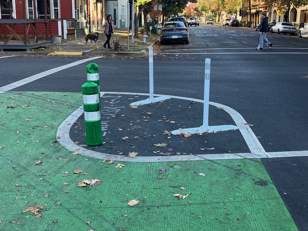
Along P Street an added double white line has been installed on some blocks, photo below. I don’t know why, but it must be to solve some issue that was not solved by the original design.
added double white line on P St
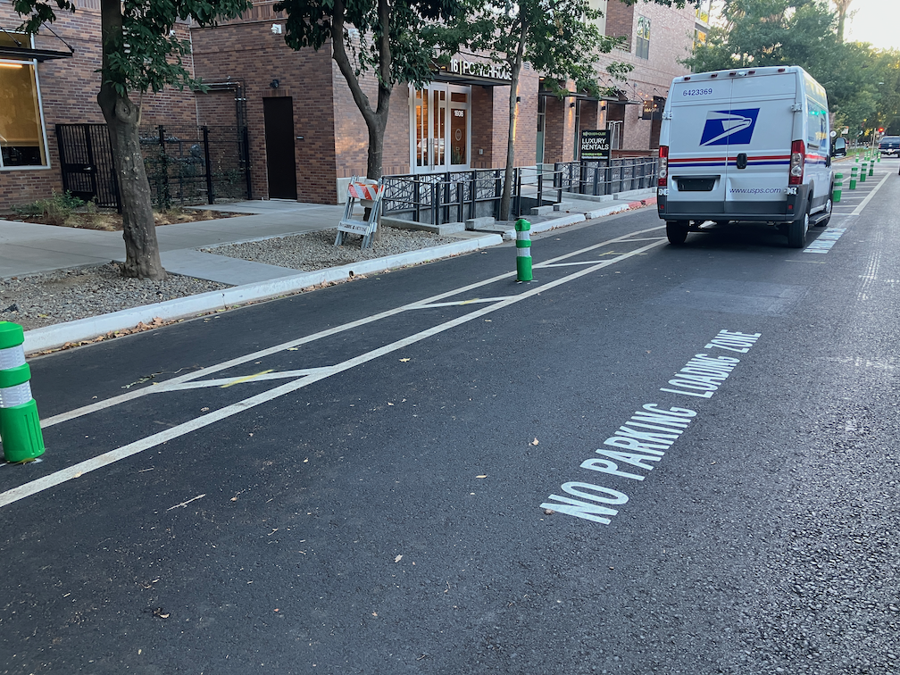
After being mostly neglected, curb designations for loading zones and short term parking have been installed in several places. The photo below shows the white curb with added pavement stencils for a loading zone on P Street approaching 16th Street. This is probably the location that was most being abused by both delivery drivers and private vehicle drivers, so this is good to see. White curb loading zones don’t have a designated time limit, and I have seen this location abused by private vehicle drivers, which should not be here at all since this designation is for commercial loading, but it is far better than before.
curb marking and pavement message for loading zone, P St
Lastly, there seems to be new activity on 5th Street, so that part of the project may be moving forward again. I’ll check it out and post.
I have not visited the south end of 19th Street, nor the south end of 21st Street, so I don’t know if those locations have been improved. Both were a mess. I’ll try to get there and report.
Work is occurring on I Street this week. The street has been marked from 21st Street to 12th Street, and some of the white striping has been completed. No green paint yet. This section is all right side of the street bikeways.
The design is rather erratic:
21st Street to 20th Street, parking protected separated bikeway
20th Street to 19th Street midblock, bike lane
19th Street midblock to 16th Street, buffered bike lane
16th Street to 13th Street, buffered bike lane
13th Street to 12th Street, parking protected separated bikeway
At the intersection of 21st Street and I Street, there are markings for dashed green bike lanes on the west, south, and east legs, adjacent to the crosswalks (not yet painted). No sign of the promised bike signal yet. The markings imply to me that bicyclists continuing north on 21st Street will have to make a two-stage crossing, first across 21st Street, and then across I Street. This is not what was advertised, which was that bicyclists would have an exclusive signal phase during which they could go to any of the three destinations without any moving motor vehicle traffic. To to seen.
21st St & I St intersection bike lane markings
At 20th Street, the street becomes three motor vehicle lanes (general purpose travel lanes) and a curb-side regular bike lane. I’m guessing this is to provide stacking area for motor vehicles when trains are crossing. Makes some sense, but it also makes the bikeway erratic, and will encourage poor behavior as drivers speed into the third lane, and then have to merge back into two lanes.
I St at 20th St, unprotected bike lane and three motor vehicle lanes
At 16th Street, the street design is two motor vehicle lanes and a buffered bike lane. The reason for this is that the Memorial Auditorium loading dock extends into the street, which was an earlier design mistake that the city made to choose auditorium convenience over people walking (Sac permanently closes sidewalk).
I St at 16th St, two vehicle lanes and buffered bike lane
12th Street is the end of the project, and I Street is again a three-lane traffic sewer towards the freeway. At 6th Street it becomes a five-lane traffic sewer.
Since work is actively going on today, I would guess that the white paint will be complete by the end of this week, and green paint added next week. There is still a national shortage of the green K-71 vertical delineators, so I would guess that only a few will be placed in the near future. There are a few places with gaps in the white stripes, which will be a designated color for parking or loading.
I have been getting questions from several people about how the turn wedges being installed as part of the Central City Mobility Project are supposed to work. In particular, this applies to all of the concrete wedges, which are at the intersection of the separated bikeways, but applies most of the other wedges as well.
First, the diagram from the Central City Mobility Project design document. This is turn wedge style 3, with concrete turn wedge. The other four styles have speed bumps and vertical delineators.
diagram, Central City Mobility Project, turn wedge style 3
Second, a photo of an actual concrete wedge in place.
photo, concrete turn wedge at 21st St & P St
The issue that has been pointed out by more than one reader is that a motor vehicle driver can also cut between the turn wedge and the curb, to the left of the turn wedge, rather than to the right, as was intended by the design. Wow! That is a flaw. How did this happen?
Well, the city has designed partially rather than fully protected intersections. Not only are these protections only on one corner, but they are not designed according to NACTO (National Organization of City Transportation Offices) guidance. Here is the NACTO diagram, from the Protected Intersections page.
NACTO Protection Intersection diagram
What is different? Look at the approach from the left side of the diagram. There is a concrete island, labeled 3, which prevents motor vehicle drivers from cutting through between the turn wedge (‘corner island’ is the NACTO term) and the curb. It is likely that the area labeled 1 would also be a concrete island. This island not only protects bicyclists, but more importantly, protects walkers and shortens the crossing distance. I will include text from the NACTO page below, because the details are really important.
So, how to fix the Sacramento problem? Concrete islands need to be installed in the upstream direction, before the crosswalk. In the case of the photo above, this would be where the photographer is standing. Without such protection, this cannot be considered in any way a protected intersection or separated bikeway (protected bikeway). The radius of the turn wedge is also much greater than the NACTO recommendation, 30 feet rather than less than 18 feet (see second bullet below). So we are back to ‘turn wedges of death‘. I have to say, this is typical of the city, to take a good idea and sort of implement it.
Thank you to the reader who pointed out this design flaw, and caused me to look more closely, and think more closely.
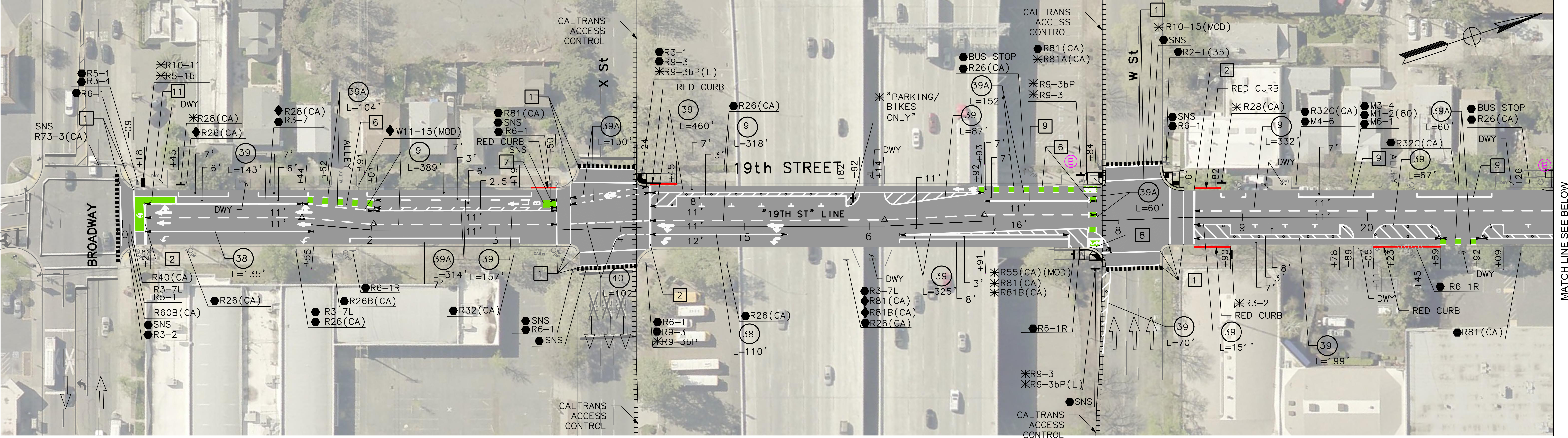
For quite some while, the project on 19th Street had stopped at Q Street, but it is now continuing south to W St. White striping is done, there is some green paint but incomplete, curb and line colors for special parking is not started, and there are no vertical delineators. The block from Q Street to the light rail tracks is a buffered bike lane, due to a street dining area at Midtown Spirits. At the tracks, there are some swooping lines, that I think are intended to encourage bicyclists to cross the tracks at a closer to perpendicular angle, but it is not finished so I can’t tell if it being properly marked. The remaining blocks to W Street are parking protection separated bikeway.
19th St at Q St, buffered bike lane
The section from W Street to Broadway has not been worked on. As is true of most of the separated bikeways, it is on the left side. South of Broadway, 19th Street becomes Freeport Blvd and is two way, with the southbound bike lane on the right side. At the moment, there is nothing to indicate how and where a bicyclist would transition from right side to left side. The two blocks are devoted to general purpose (motor vehicle) lanes, and is not a comfortable place for a bicyclist to be.
In the design diagrams, the transition appears to be at W Street, with no particular accommodation for bicyclists. Though the design diagrams do not indicate operations, just striping and signing, it looks as though bicyclists will cross W Street on the east side, with the regular signal, and then 19th Street on the south side, with the regular signal. There is no indication that the bicyclist crossing 19th Street will be protected from left turning motor vehicle traffic by an exclusive phase. Green paint is not sufficient communication for most drivers, hard physical control is required, such as no left turn during the bicyclist movement. I suspect, based on city implementation in other locations, that it was decided that an exclusive bicyclist phase was ‘not practical’ because it would slow motor vehicle drivers a bit.
19th Street from W Street to Broadway
I believe that the city should develop and install signing specifically for bicyclists on the transition points, where a bikeway either ends or transitions to the other side. There is no indication that the city has done or intends to do this. The diagram indicates a R55(CA) (MOD) sign on the southeast corner, which is a mystery, since the standard R55 sign is ‘yield to uphill traffic’. Of course neither the federal MUTCD nor the California CA-MUTCD, which is similar, has much in the way of guidance or signage for bicycle facilities, since in the mind of FHWA and Caltrans, bicyclists are an afterthought. There are several note references around this intersection, several of which I have been unable to locate in the design document, but they must exist somewhere. Be aware that the city has ‘invented’ a number of traffic control signs that are not compliant with CA-MUTCD, so the excuse that there isn’t an official sign is just stonewalling on the part of the city.
I Street
There has been no work on I Street in quite a while, since the resurfacing, but there are new ‘no parking’ signs posted with control starting today, 2023-09-19, so perhaps work is about to start again.
Concrete islands have been installed for the turn wedges at P & 21st, P & 19th, Q & 19th, and just today, at P & 9th and Q & 9th. The planned locations of these turn wedge islands are the intersections of the separated bikeways. The Q & 21st one is not installed yet, and I did not see any on 10th. The other intersections will have a different treatment, rubber speed bumps and vertical delineators.
The islands are centered by stamps red concrete. The curbs are four inches, and sloped at about 45 degree angle. Apparently these are poured on top of the pavement, I did not see any sign of excavation below the surface.
In a brief observation, about 20% of the turning drivers hit these islands. This is not surprising, as they are new, and drivers have gotten used to taking these corners at high speed, passing over what was just painted areas. I admit I almost hit one, as I had been riding straight through these intersections rather than swooping with the markings. But I pay more attention that most drivers, so I didn’t hit it.
Apparently the purpose of these is not to provide a wait area or bike box for bicyclists, but to slow drivers and have them pointing more perpendicularly to the bikeway and crosswalk, so they are more likely to see other people. But they do offer an area where bicyclists can get out ahead of and more visible to drivers.
concrete turn wedge island at P St and 21st St
Updates
P Street, Q Street, 21st Street: No significant changes.
19th St: Markings for the separated bikeway are marked from Q Street at least as far south as S Street. Not observed south of there.
I Street: No change, still just lane marking tabs. Paving was continued to 12th Street, so it is possible the project will be extended that far, but as designed, the separated bikeway and lane reduction ends at 15th Street.
10th Street: No significant change, is largely complete but some marking and delineators are still missing.
9th Street: I had speculated that the project would not be completed from L Street to Q Street, but it has been marked and partially painted now. There is a left side regular bike lane (two white lines but no buffer) from L Street to O Street, then mixed left side bike lane and separated from O Street to Q Street.