The SacBee published an article yesterday: After a deadly crash, Sacramento fixed a dangerous road. Why isn’t this the norm? Apologies for linking to a firewalled article; if you have a subscription or access to a printed newspaper, it is well worth reading.The article is quite in-depth, more like the investigative reporting that the SacBee used to do, but rarely does any more. The author is Ariane Lange.
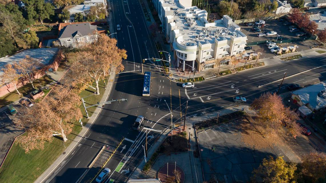
The article highlights changes made to the intersection of Broadway and Martin Luther King, Jr. Blvd (MLK) after a fatal crash single-vehicle crash in 2021. Though the article did not make clear, the driver was likely eastbound on Broadway and continued straight into the building. Google maps, below, does not show the changes, but a photo from the article does (second).
Broadway & MLK intersection, Google Maps (not up to date)Broadway & MLK, SacBee photo (more recent)Read More »
The Sacramento Active Transportation Commission (SacATC) will meet on Thursday, January 18, at 5:30PM. This meeting will be at Historic City Hall, hearing room 2nd floor, though it usually meets in council chambers in new city hall. You can watch in person or online via https://meetings.cityofsacramento.org. You can comment via the eComment function on the meetings page, and in person. eComments are placed in the meeting record, but if you want to be heard, you must attend. Apparently Zoom is no longer available.
Agenda
Commission Staff Report (Oral Report)
Consent Calendar
Approval of Active Transportation Commission Meeting Minutes
Active Transportation Commission Log
Discussion Calendar
Selection of Chair and Vice Chair for Calendar Year 2024
Draft Work Zone and Event Detour Policy
Log Item Report Back: Sacramento’s Alleys
Commissioner Comments – Ideas and Questions
Public Comments-Matters Not on the Agenda
Work Zone
The most important agenda item is 4, Draft Work Zone and Event Detour Policy. I have several prior posts on this. Please read if you want to make comments. Though there could be a number of improvements to the policy, it is overall very good, and far, far better than anything that exists today. The two critical improvements are that the policy must address PROWAG (Public Right of Way Accessibility Guidelines), which are now the law of the land (though not yet enforceable until adopted by US DOT and US DOJ), and that there must be monitoring of all projects that are more than one day duration. The city has claimed that they have contractors (not the construction companies, but separate compliance contractors) monitoring at least once, but clearly that is not happening, as there are violations of ADA on nearly every construction project, and corrections are either slow to occur or never occur.
STAR, Sacramento Transit Advocates and Riders, has created several posts on Truxel Bridge, the City of Sacramento effort to add a motor vehicle, transit, walking and bicycling bridge over the American River in alignment with Truxel Road. The STAR interest is that the original bridge proposal, approved by Sacramento County under the American River Parkway Plan and by SacRT, was for a bridge that carried light rail, walking and bicycling, not motor vehicles.
View these posts, and likely more to come in the future, on STAR at category ‘Truxel Bridge‘.
I attended the Work Zone and Event Detour Policy Roundtable on January 9, with city staff and various stakeholders. All present agreed that current practice was unacceptable. Two companies that provide construction signing for projects talked about the challenges, including signs and barricades being placed and then moved by the public. I pointed to the two most important issues not addressed in the draft policy: 1) the policy must be explicit about requirements in PROWAG, and 2) the policy is meaningless if there is no monitoring. A number of people had anecdotes about projects that failed to offer accommodation for walkers and bicyclists, in addition to the hundreds of 311 reports that I have filed.
Posts related to the work zone guidelines are linked via category ‘Work Zones‘ within City of Sacramento category. Posts about construction project issues, previous to and after the release of the draft guidelines, of which there are a huge number, are linked via tag ‘construction zone‘ within Active Transportation category.
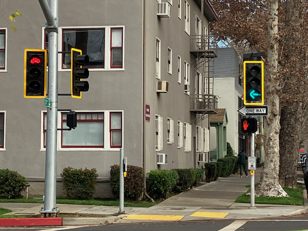
The 19th Street bikeway has been completed from W Street to Broadway. Only a half block of the two blocks is separated bikeway, and it is on the right side rather than left side as it is to the north. At W Street there is a bike box in line with the bikeway to the north, and a green dashed bikeway to carry the bikeway from the left or east side to the right or west side. The curved area shown in the photo does not have any sort of protection to reduce turn speeds, as is present on most turn wedges in the rest of the Central City Mobility Project.
The turn intersection involves a two stage turn for bicyclists, once to cross W Street to the south side, and then to cross 19th Street to the west side. There is no separate bicycle phase or bicycle signal face here. The pedestrian crossing phohibition here and lack of crosswalk indicates two things: there is no sidewalk on the south or freeway side of W Street, and that high speed turns from W Street to 19th Street are expected and encouraged. This project would have been a great time to add a crosswalk and pedestrian signaling here, and remove the prohibition, as both sides of 19th Street under the freeway have sidewalks, so a crosswalk would speed travel for walkers by offering two routes of travel. Bicyclists using the green dashed crossing of 19th Street have turning traffic at their back, which is somewhat unsafe but could have been made safer with an exclusive bicyclist phase or even a bicyclist signal phase. Since the signal timing favors W Street over 19th Street, it could have been possible to allow both a brief bicyclist phase and a turning phase.
19th St bikeway transition to right side
Crossing under the freeway, the bikeway is partly green painted and next to a travel lane, and partly parking protected bikeway to X Street. From X Street to Broadway, it is a regular door-zone bike lane. At Broadway, there a green bike box the full width of the street, allowing bicyclists to continue straight or turn left onto Broadway.
To summarize, the design is OK but could have been better.
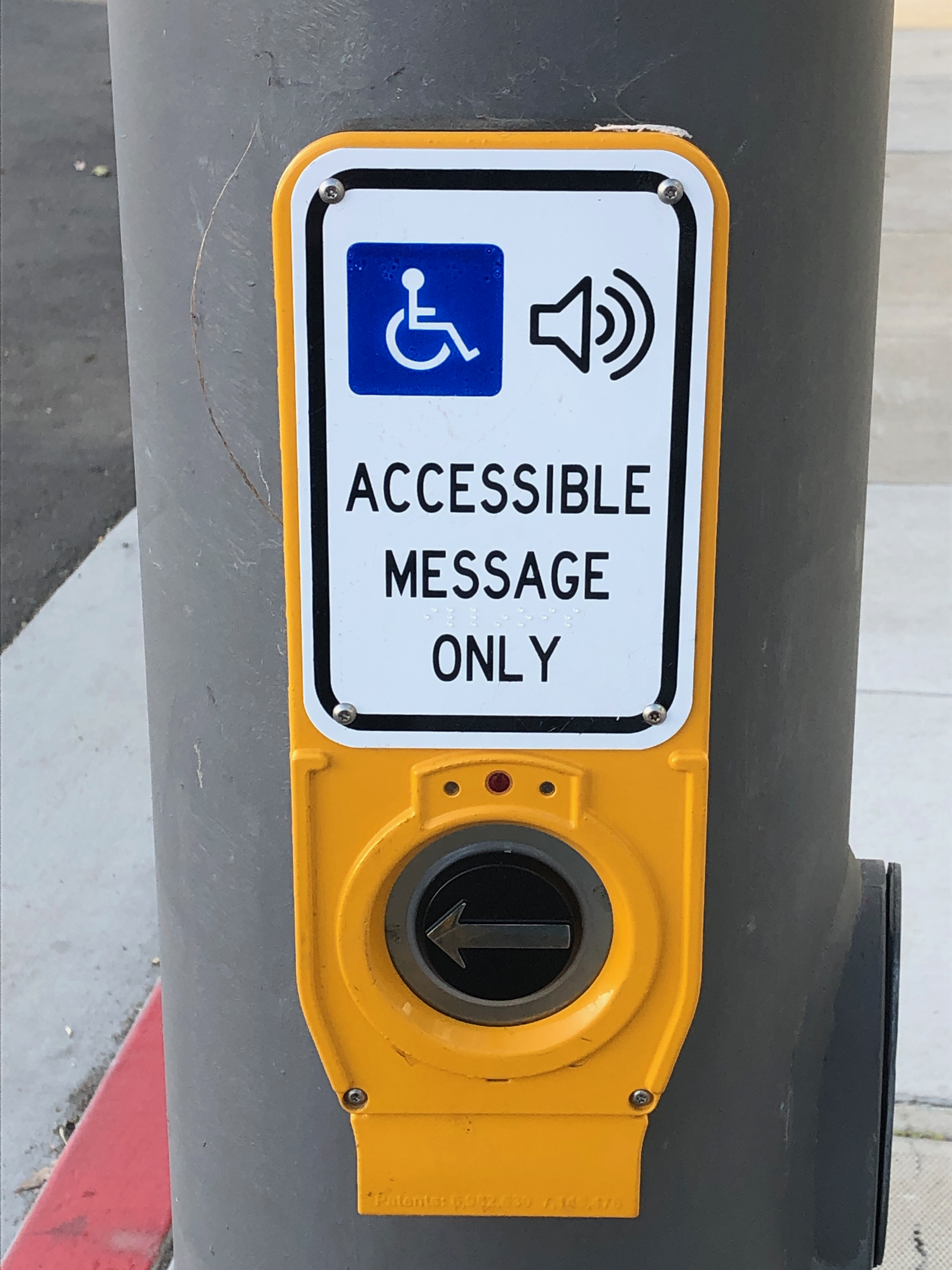
A previous post about new beg buttons on Alhambra Blvd noted that there are now beg buttons where there used to be auto-recall pedestrian crossings. I walked Alhambra this week, and noted that there are eight intersections with these new beg buttons (technically called pedestrian actuators or Accessible Pedestrian Signals APS). At auto-recall crosswalks, the pedestrian signal comes on at every signal cycle. At beg button crosswalks, the signal comes on only if requested by the pedestrian. The city has many of both types of crosswalks, but these particular locations are new. The intersections are Alhambra and: J Street, K Street, L Street, Capitol Avenue/Folsom Blvd, N Street, P Street/Stockton Blvd, Q Street, S Street. At each intersection there are eight of these new beg buttons on new posts, for a total of 64 new beg buttons.
No one seems to know who authorized this project, nor what funds were used to pay for it. I have confirmed that the project never came before the Active Transportation Commission (SacATC). All significant pedestrian projects are supposed to come before SacATC, and the fact that this one did not probably indicates that the staff in Public Works knows that this is a motor vehicle project, and not a pedestrian project. Though it is a good bet that pedestrian safety funds were used to pay for it.
Though these beg buttons are not signed with the ‘wave at’ sign R10-3j(CA) that the new ones at 21st Street and I Street, they do seem to have the same function, that they detect people, waving or not, up to about 18 inches. It seems odd that the city would have purchased these infrared detector actuators, which must be more expensive than plain touch buttons, but then did not indicate them as such. Installation of new accessible pedestrian signals is about $70K per intersection, though replacement of buttons at existing locations is only about $14K per intersection. I have been unable to find costs for passive detection systems (they all seem to require a quote process).
A reminder, if one is needed, that beg buttons have no safety benefit for people walking. They are a motor vehicle device, meant to reduce the length of signal cycles so that more cars can go faster.
The solution to this is to prohibit the use of pedestrian beg buttons throughout the city. Existing locations can be converted to the audible crossing signals that are now required by PROWAG. The relevant sections of PROWAG are R307 Pedestrian Push Buttons and Passive Pedestrian Detection and R308 Accessible Pedestrian Signal Walk Indications. Unfortunately PROWAG does not have a definition for ‘passive detection’ to specify what the detection radius or functionality is. It might be presumed this is the same at automated pedestrian detection, but not certain. Under PROWAG, new or changed locations require audible signals, but this can be met by audible/tactile push buttons or passive detection.
San Francisco is replacing the signing on their pedestrian actuator locations with the signing below.
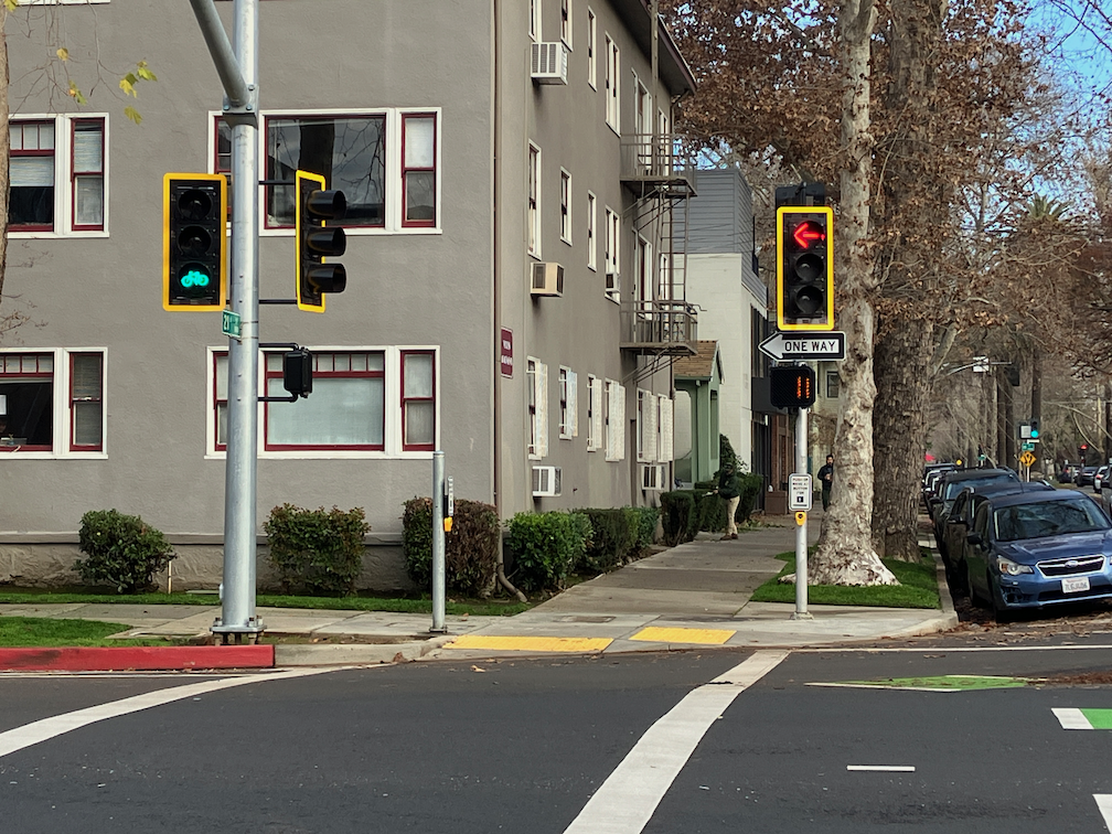
The bike signals and related signaling is now installed at the intersection of 21st Street and I Street, where the northbound 21st Street separated bikeway ends, and the westbound I Street separated bikeway begins. East of this intersection, I Street is two-way. The I Street bikeway is on the north side, right side, so bicyclists must transition from the southwest corner to the northwest corner. Bicyclists continuing north on 21st Street must also transition from the left side bikeway to the right side general purpose lane.
The city has attempted to solve this problem by installing bicycle signal faces on the northwest corner, for bicyclists turning left on I Street, and the northeast corner, for bicyclists going straight on 21st Street. The photos below show the northwest corner bicycle signal green and turn arrow red, bicycle signal red and turn arrow green, and the bike signal on the northeast corner.
21st & I St, bicycle signal green and turn arrow red21st St & I St, bicycle signal red and turn arrow green21st & I St, bike signal on the northeast corner
The signals are set up so that bicyclists, and walkers on the west leg of the intersection, have an exclusive phase, meaning that no cars are supposed to be moving when the pedestrian signal shows walk, or the bike signal is green. Actually, triggering the bike signal also triggers the pedestrian signal, and vice versa, they are ganged together.
The problem is that drivers are turning left from 21st Street to I Street against the red arrow, endangering bicyclists going west and north, and walkers in the crosswalk. In about 30 minutes of observation over the last few days, I saw drivers turning left against the red about half of all signal cycles. Once the front driver decides to turn, all other drivers follow. I did not see any drivers turning from the right hand left-turn-straight lane.
California Vehicle Code (CVC) 21453 says: (c) A driver facing a steady red arrow signal shall not enter the intersection to make the movement indicated by the arrow and, unless entering the intersection to make a movement permitted by another signal, shall stop at a clearly marked limit line, but if none, before entering the crosswalk on the near side of the intersection, or if none, then before entering the intersection, and shall remain stopped until an indication permitting movement is shown.
So, every single one of the drivers who turned left on the red arrow was breaking the law. Sadly, the city has designed an intersection that assumes drivers will not break the law, but as every bicyclist and walker knows, drivers do so pretty much continuously. I do not know what the solution is for this intersection. It is difficult to control driver behavior. In any other situation than roadways, the behavior of routinely breaking the law is called lawlessness.
Signal actuation (beg buttons)
In addition to the new signals, there are signal actuators, generally called beg buttons. Nothing here is on auto-recall, meaning there is not a bicyclist and pedestrian phase on every signal cycle, but only when requested.
The actuator for the pedestrian signal is shown below. This is first placement of this technology in the city, so far as I know. The sign is CA-MUTCD R10-3j (CA). The ‘wave at’ function is an infrared proximity detector, that works for up to about 15 inches, and also works for standing as well as waving. An example commercial product is WiAPPS Wave, though I don’t know what vendor the city used. It is not automated pedestrian detection, which would cover the full width of the sidewalk.
pedestrian actuator (beg button), 21st St & I St
Strangely, the bicyclist actuator (beg button) does not have this technology; the bicyclist must actually touch the button.
The Broadway Complete Streets project, to reallocate the street from 3rd Street to 24th Street, is underway. I have been walking this section recently, and I see several things that greatly concern me. To be honest, I was not paying much attention when this project went through public review, and attended only one meeting. I had not looked closely at the project documents. The page linked above confuses me. There are no final design documents, yet I have several documents more recent, including one that says final. Did the city unlink these newer documents? Lose them?
It appears from the work I see being done currently, that parking will be preserved along the entire length of the project. While this makes complete sense where there are small businesses, there are also several blocks where there are large buildings that provide off-street parking, or fast food chain restaurants that that have ample off-street parking. Parking can be a good thing, but not when it takes the place of wider sidewalks and sidewalk buffers.
One positive is that vertical curbs are being installed, replacing the rolled curbs that exist along much of the street at this time. But a negative is that apparently curb lines are not being moved as part of the project, meaning that under-width sidewalks and under-width sidewalk buffers will remain so. A diagram from the planning process shows eight foot sidewalks.
diagram of proposed roadway allocation
Here is an actual constructed section, north side between 18th and 19th Streets. The sidewalk is six feet, and a completely useless sidewalk buffer of about 18 inches is included. A sidewalk buffer this narrow cannot provide planting space, and does not provide any physical or visual separation from the street. The street width could have been reallocated to a wider sidewalk, and a sidewalk buffer wide enough to host trees, but it was not.
Broadway narrow sidewalk and narrow buffer new constructionRead More »
Posts related to the work zone guidelines are linked via category ‘Work Zones‘ within City of Sacramento category. Posts about construction project issues, previous to and after the release of the draft guidelines, of which there are a huge number, are linked via tag ‘construction zone‘ within Active Transportation category.
I walked a long section of Broadway today, and came across two construction projects that close sidewalks without proper and safe signing and barricades.
‘Dental Clinic Remodel’
I put this one in quotes because it is a building that has been abandoned for years, but is apparently now under construction. Construction for this half-block building on the north side of Broadway between 23rd and 22nd Streets has closed sidewalks on both 23rd and 22nd. For 23rd, there is some signing, but also a non-detectable chainlink fence and trips hazard folding barricade. As with many other construction projects, a sign on hand, the bicycle/pedestrian detour sign (MUTCD M4-9a), was used though it is not required or appropriate. The sidewalk closed ahead cross here (MUTCD R9-11) is a valid sign, but the wrong location. The sidewalk is closed HERE, not ahead, so the correct sign is sidewalk closed cross here (MUTCD R9-11a).
work zone violation at Broadway and 23rd St, wrong sign, non-detectable barricade
At the corner of Broadway and 22nd Street, there is no sign at all, and the same non-detectable chainlink fence used as a barricade.
work zone violation at Broadway and 22nd St, no sign, non-detectable barricade
I did not check on the north side of these sidewalk closures, but I would assume the signing and detectability is the same or worse.
There is a new development occurring on the southwest corner of 16th Street and E Street, 30 affordable apartments, apparently called Studio 30. This is something that I always support, more housing, more affordable housing.
apartment construction at 16th St & E St, southwest, called Studio 30Read More »