SacCity: Franklin Blvd Phase 3

The SacATC 2026-10-15 meeting will receive a information and comment update on the Franklin Blvd Complete Street Phase 3 project. The project is at the 60% design stage, meaning that plans have been drawn (see the SacATC 2026-10-15 post), but details can still be improved. I have had some time to review the presentation and design diagrams, so have some comments, based on these and on my previous post on the Phase 1 and 2 project which is complete. The Phase 1 and 2 project ended at Fruitridge Road. There have been various city and county projects on other segments of Franklin.

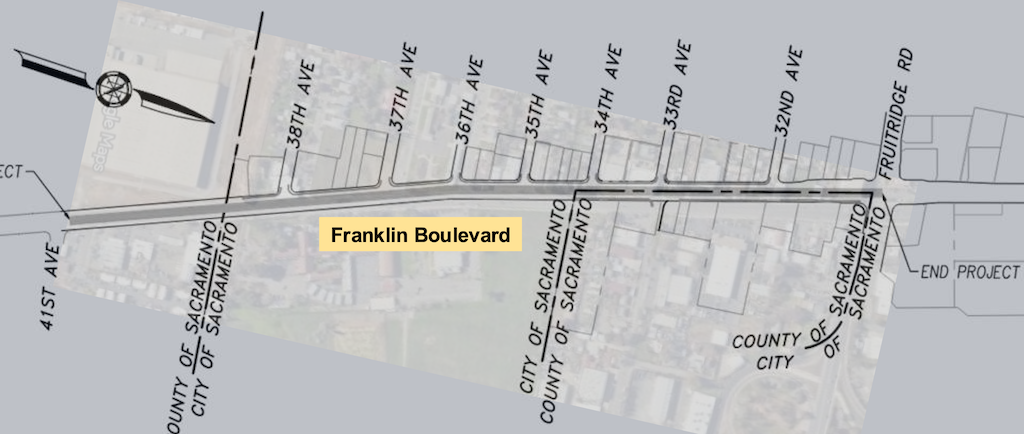
The extent of this Phase 3 project is Fruitridge Road to the county line just beyond 38th Avenue, shown below. The southern part of the project (to the left) is in the city, and the northern part (to the right) is shared city and county, but the city is taking responsibility for the entire project.
I note four areas of concern.

One: RRFB (Rectangular Rapid Flashing Beacon) at 33rd Street. RRFBs have a very low rate of compliance in the City of Sacramento, in part because we have among the worst drivers in the state. The installation here includes two beacons, one on the post, and another on an overhead mast arm. This format may slightly increase compliance, but the city has not demonstrated that it increases compliance enough to be safe for people crossing here. The city knows that existing RRFB locations are not safe, but continues to specify them, against the advice of transportation advocates. Either there should be a pedestrian hybrid signal at this location, or it should not be highlighted as a safe crossing, because it is not. Of course every intersection has a crosswalk, whether marked or unmarked, but the presence of a marked crosswalk with RRFB signal implies a level of safety that does not exist.

Two: Flared intersection at Fruitridge. The flared intersection of Franklin Blvd southbound at Fruitridge, which I criticized in my previous post as being unsafe for all users, is proposed to be duplicated south of the intersection in this Phase 3. The Google map overview is below. North of Fruitridge, the configuration has changed somewhat. South of Fruitridge, it is as shown, with two lanes southbound, two lanes northbound, a dedicated left turn lane, and a dedicated right turn lane which is a free-right with no traffic control whatsoever.
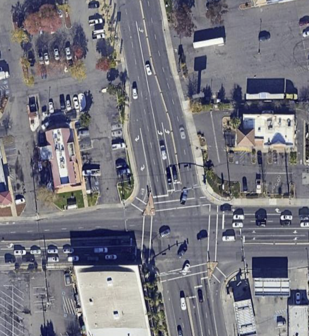
Google map of Franklin - Fruitridge intersection
Google map of Franklin – Fruitridge intersection

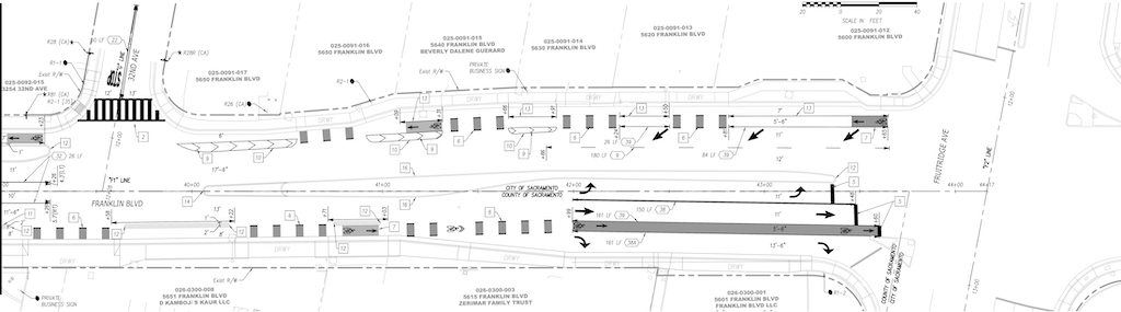
The design diagram for Franklin at Fruitridge is below. It shows some improvement, with only one lane northbound, but is otherwise the same. Two lanes southbound, requiring a merge that could be avoided by making it one lane, as it is on the approach from the north, and one of the lanes is 12 feet, unnecessarily wide. The southbound bike lane is 5.5 feet, too narrow, and does eventually have painted buffer ‘protection’. The dangerous dedicated right turn lane is retained, though it does add a stop sign, which would be widely ignored, and encourages the same driver behavior to look left and ignore anyone in the crosswalk. The lane is 13.5 feet wide, which is ridiculous. The marked northbound bike lane is 5.5 feet, too narrow, between two motor vehicle travel lanes, with no protection whatsoever.
Three: Trees and sidewalk buffers (planting strips). Though sidewalk buffers and trees are being added along about half of the segment, both are missing from the remainder. This is better than it was, but far from the tree canopy/shade that the public has requested. Though I could not find a diagram where the width of the sidewalk buffer was specified, I estimate that they are mostly five feet, but narrower in a few locations. Healthy trees require eight feet or more, so the trees along this section will always be less healthy than they could be. Tree information starts on page 61 of the design diagrams document, with Landscape Planting Legend (LP002), and includes six street sections. A total of 50 trees are indicated, though it is doubtful, given past projects, that all of these will be planted. The diagram below shows the 37th Street section, with more trees than any other.
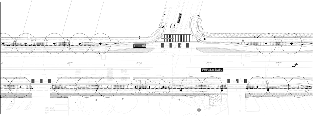
diagram of Franklin-37th Street section, Landscape Planting Plan LP102
Franklin-37th Street section, Landscape Planting Plan LP102

Four: Wide concrete bikeway medians. There are a number of locations with very wide concrete medians to separate the bikeway from travel lanes. I’m all in favor of concrete medians, which provide real protection rather than the visual protection of vertical delineators. But a narrow concrete median is just as effective in providing protection as a wide median. In many cases, these medians seem overly wide, as though to simply take up excess space. Though the stamped concrete specified for many of them is slightly better aesthetically than plain concrete, it is still an unnecessary expanse of heat generating and expensive infrastructure. If possible, this width should be reallocated to sidewalks and sidewalk buffers.
SacATC 2026-10-15

The Sacramento Active Transportation Commission (SacATC) will meet this Thursday, October 15, 2026, starting at 5:30 PM, at the city council chambers. People can comment on agenda items in person at the meeting, or by making an comment ahead of time online. Though comments up through the meeting become part of the record, commission members will not see comments unless they are submitted early the day of the meeting or before.

The method for speaking in person has changed. Go to the city’s Public Participation Hub page, and then select Sacramento Active Transportation Commission (note: this page works poorly on handheld devices), and then click on the ‘View Page’ button. Select ‘Register’ to register for the meeting and to speak on an agenda item. Select ‘Comments’ to make a comment, or view other’s comments. You may also use the meeting kiosk to register in person. There are no longer speaker cards available. Once an item has been announced by the chair, it is not possible to register to speak on that item.

Select ‘Files’ to download the agenda. Within that document are links to individual agenda item documents, and these can be downloaded. All of this is much more awkward that the previous meeting mechanism. Check it out ahead of time so you can figure it out. I have made the documents for the three primary agenda items available below, so you don’t have to go through the awkward interface.


Agenda (pdf)

Consent Calendar

  1. Approval of Active Transportation Commission Meeting Minutes
  2. Active Transportation Commission Log

Discussion Calendar

  1. North Natomas Community Trail Naming Effort
  2. Franklin Boulevard Complete Street Phase 3 Project (T15255600): staff report | presentation | diagrams
  3. Active Transportation Commission 2026 Annual Report Draft Recommendations: staff report | report | presentation

I do not have any comments to make at this time, but may tomorrow.

I have not had time to analyze Franklin Phase 3. My comments on the earlier and complete phase are at SacCity: Franklin Blvd complete street, and may be of use.

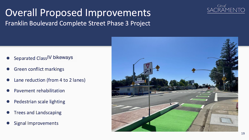
Franklin Blvd Phase 3, overall proposed improvements, slide from SacATC presentation

I have not had time to look at the SacATC annual report in detail. Meanwhile, the recent email from Slow Down Sacramento/Isaac Gonzalez is of interest. Of course, I recommend that you join the Slow Down Sacramento email list yourself.

SacCity: Franklin Blvd complete street

The Franklin Blvd complete streets project is… complete, with a ribbon cutting that occurred on Tuesday morning. This is a project that I have not been paying attention to, but I visited it to see what it is like. It spans Sutterville Road on the north to Fruitridge Road on the south, with the part south of Fruitridge to the county line not constructed. It is about 1.1 miles. Franklin Blvd runs from Broadway 25 miles to well south of Elk Grove, including the crossroads of Franklin, for which it was named. This section of Franklin is largely commercial, with small remnants of residential. The section north of here, to Broadway, is largely residential with some commercial, and is a much slower and calmer street.

The only publicly available document is the initial October 2019 plan. This plan included three similar but not same options. No information is available on what was actually built.

Though this project is complete, an analysis of what worked and what didn’t could help improve future complete streets projects that the city might undertake.

Bikeway: A separated bikeway was created along the corridor. It is protected by concrete curbs or medians for about half of its length, but some paint only sections remain, and the bikeway is interrupted by frequent driveways. Still, it was fairly well done. The initial diagrams show protected intersections with high quality bicycle facilities, but the actual construction at intersections is only slightly protected. OK.

Trees: The initial plan includes this sentence: “Plant trees along street at approximately 30 feet apart, on-center, to provide shade and cooler temperatures.” If implemented, this would result in about 350 trees along the segment. There are 30. Failure. In addition, the trees are mostly in 5.5 foot wide sidewalk buffers (which the city calls planting strips), whereas trees need at least 8 feet to remain healthy and reduce sidewalk heaving. Failure.

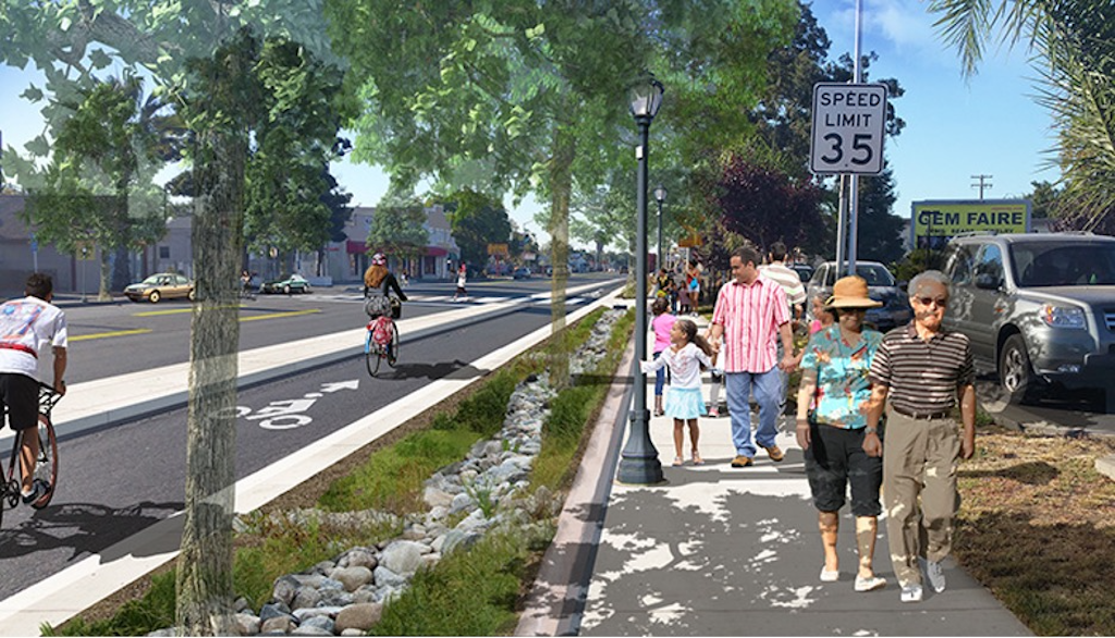
The photo below is a mock-up from the initial plan. It is standard practice for city projects to show more trees than they intend to install. Gaslighting the public.

mock-up photo from initial complete streets plan

Other plantings: The initial plan indicated there would be bioswales throughout the project, but I saw only one small one. The plantings in sidewalk buffers are aesthetically pleasing, but not environmentally significant.

Sidewalks: Some sidewalks were upgraded to 6 feet, which is the modern minimum. Ramps were installed at intersections. Driveway crossings are a mix of acceptable and illegal, with cross-slopes in the sidewalk. Other sidewalks were left in their original condition of 4.5 to 5 feet. Falls short.

Sidewalk amenities: There are some trash cans provided by Franklin Blvd Business District. I did not see any other amenities. Weak.

Lighting: Pedestrian-scale lighting, with traditional poles, was installed along the length. The old motor-vehicle scale lighting was left in place. Though I did not visit the street at night, lighting looks to be a great improvement.

Driveways: There are a huge number of driveways in this section, largely due to the traditional development pattern of small business buildings on small parcels, with parking between the street and the building. This is an unfortunate pattern, but not something that can easily be fixed. Most driveways were replaced with a slope in the sidewalk buffer, or more commonly, dip down and back up, which is legal but not ideal. There are several driveways for long abandoned businesses and empty parcels, which should have been closed under the city’s driveway closure policy.

Safe crossings: There are existing signals at Sutterville Road/12th Avenue, 21st Avenue, Atlas Avenue (full pedestrian signal), 26th Avenue (to the west), and Fruitridge Road. At 18th Avenue, there is a new enhanced RRFB (Rectangular Rapid Flashing Beacon). There are RRFBs on a signal mast arm, in addition to at the side, perhaps safer than a standard RRFB, but given driver behavior in Sacramento, not safe. The distance from 26th Avenue to Fruitridge is just over a quarter mile, though there may not be a good location for a crossing in this stretch. The distance from Sutterville/12th Avenue to 18th Avenue is well over a quarter mile, which is an unacceptable distance between safe crossings.

Curb extensions: There was an opportunity to shorten crossing distances and slow drivers by providing curb extensions on the side streets. This was not done.

Bus: SacRT Route 67 runs on Franklin from Broadway to 21st Avenue. There is a pull-out bus stop just south of Sutterville/12th Avenue, which is a timepoint and may be appropriate, though pulling out of traffic, and back in, is poor practice. The other bus stops are in shared bus/bicycle areas, which is probably fine for a low frequency route (30 minutes). It occurs to me that it might be better to run service south on Franklin to Fruitridge Road, to consistently serve the commercial area. The route on Martin Luther King Jr Blvd does serve residential areas, but those are constrained by Hwy 99 to the west and a poor street grid, and the route misses Christian Brothers High School.

Franklin Blvd & Fruitridge Road intersection: This wide flared intersection is hazardous for all users, and nothing was done to improve it. Southbound, Franklin flares from one travel lane to two dedicated left turn lanes (unnecessary and unsafe), one uncontrolled dedicated right hand turn slip lane (highly dangerous for bicyclists and walkers), and one through lane. Everything that was good about the complete streets project gets tossed out the window at this intersection. I realize that it might have only been possible to fix the north leg of the intersection with this project, but no effort was made to do so. Complete failure.

photo of Franklin Blvd southbound at Fruitridge Rd, uncontrolled slip lane
Franklin Blvd southbound at Fruitridge Rd, uncontrolled slip lane
overhead of Franklin Blvd & Fruitridge Road intersection
overhead of Franklin Blvd & Fruitridge Road intersection (only one southbound lane now)