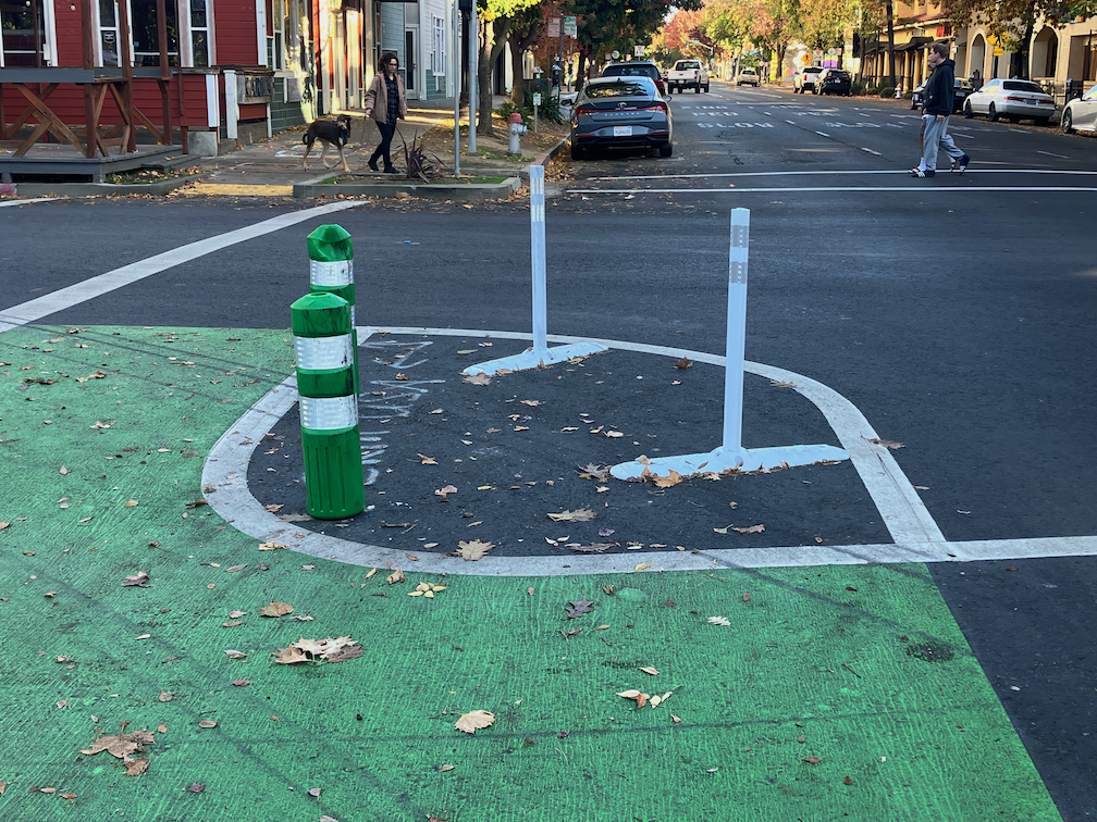
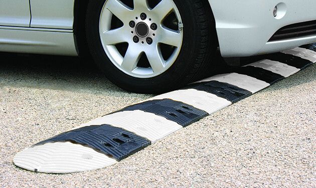
The rubber speed bumps have finally been installed on most of the non-concrete turn wedges. These are marked by vertical delineators, as shown below. it is odd that most of these installations have both green K-71 vertical delineators in addition. These K-71s might have been installed temporarily, while waiting for the rubber speed bumps, and be removed later, or may be permanent. In some of the locations, the white vertical delineators have already been hit and bent by errant drivers. I have not visited all of the locations where the rubber speed bumps have been installed (or not), so don’t have any more information. More info about the rubber speed bumps is available from the vendor TreeTop Products.
turn wedge at 16th St & P St, with green K-71 delineators and rubber speed bumpsRead More »
It has been a long while since I’ve posted on the Central City Mobility Project. I’ve been traveling, and backpacking, and project implementation has slowed down.
I Street is largely complete, from 21st Street to 12th Street. Part of the route is pretty standard separated bikeway, as below, but of the new bike facilities, it is the most erratic, changing design almost every block. The bikeway, at 16th Street, second below, is not a bike facility at all, but a car facility, designed to not inconvenience drivers turning right from I Street to 16th Street.
I St at 21st St separated bikewayI St at 16th St separated bikeway across motor vehicle turn lane
The concrete turn wedges were being hit by drivers frequently (and some bicyclists), shortly after they were installed. Reflective strips were added, below, and most drivers have gotten accustomed to the turn wedges and are not hitting them, but it continues on a rarer basis. I believe that additional warning signing is going to be installed on the turn wedges, but I haven’t seen this yet.
reflective strips on concrete turn wedges
The concrete turn wedge at Q Street and 21st Street was never installed, so it may have been dropped from the plan.
The paint, not concrete, turn wedges have had K-71 green vertical delineators installed, making them somewhat more visible, and somewhat more respected by drivers. The promised rubber speed bumps have not been installed anywhere, probably a supply chain issue.
The promised bicycle signal at 21st Street and I Street is still not installed.
Though most of the separated bikeways have received green K-71 vertical delineators, a few have not.
Along P Street an added double white line has been installed on some blocks, photo below. I don’t know why, but it must be to solve some issue that was not solved by the original design.
added double white line on P St
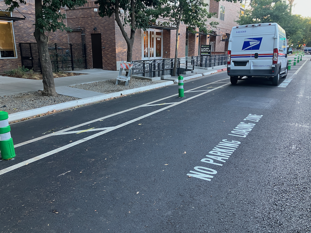
After being mostly neglected, curb designations for loading zones and short term parking have been installed in several places. The photo below shows the white curb with added pavement stencils for a loading zone on P Street approaching 16th Street. This is probably the location that was most being abused by both delivery drivers and private vehicle drivers, so this is good to see. White curb loading zones don’t have a designated time limit, and I have seen this location abused by private vehicle drivers, which should not be here at all since this designation is for commercial loading, but it is far better than before.
curb marking and pavement message for loading zone, P St
Lastly, there seems to be new activity on 5th Street, so that part of the project may be moving forward again. I’ll check it out and post.
I have not visited the south end of 19th Street, nor the south end of 21st Street, so I don’t know if those locations have been improved. Both were a mess. I’ll try to get there and report.
Work is occurring on I Street this week. The street has been marked from 21st Street to 12th Street, and some of the white striping has been completed. No green paint yet. This section is all right side of the street bikeways.
The design is rather erratic:
21st Street to 20th Street, parking protected separated bikeway
20th Street to 19th Street midblock, bike lane
19th Street midblock to 16th Street, buffered bike lane
16th Street to 13th Street, buffered bike lane
13th Street to 12th Street, parking protected separated bikeway
At the intersection of 21st Street and I Street, there are markings for dashed green bike lanes on the west, south, and east legs, adjacent to the crosswalks (not yet painted). No sign of the promised bike signal yet. The markings imply to me that bicyclists continuing north on 21st Street will have to make a two-stage crossing, first across 21st Street, and then across I Street. This is not what was advertised, which was that bicyclists would have an exclusive signal phase during which they could go to any of the three destinations without any moving motor vehicle traffic. To to seen.
21st St & I St intersection bike lane markings
At 20th Street, the street becomes three motor vehicle lanes (general purpose travel lanes) and a curb-side regular bike lane. I’m guessing this is to provide stacking area for motor vehicles when trains are crossing. Makes some sense, but it also makes the bikeway erratic, and will encourage poor behavior as drivers speed into the third lane, and then have to merge back into two lanes.
I St at 20th St, unprotected bike lane and three motor vehicle lanes
At 16th Street, the street design is two motor vehicle lanes and a buffered bike lane. The reason for this is that the Memorial Auditorium loading dock extends into the street, which was an earlier design mistake that the city made to choose auditorium convenience over people walking (Sac permanently closes sidewalk).
I St at 16th St, two vehicle lanes and buffered bike lane
12th Street is the end of the project, and I Street is again a three-lane traffic sewer towards the freeway. At 6th Street it becomes a five-lane traffic sewer.
Since work is actively going on today, I would guess that the white paint will be complete by the end of this week, and green paint added next week. There is still a national shortage of the green K-71 vertical delineators, so I would guess that only a few will be placed in the near future. There are a few places with gaps in the white stripes, which will be a designated color for parking or loading.
I have been getting questions from several people about how the turn wedges being installed as part of the Central City Mobility Project are supposed to work. In particular, this applies to all of the concrete wedges, which are at the intersection of the separated bikeways, but applies most of the other wedges as well.
First, the diagram from the Central City Mobility Project design document. This is turn wedge style 3, with concrete turn wedge. The other four styles have speed bumps and vertical delineators.
diagram, Central City Mobility Project, turn wedge style 3
Second, a photo of an actual concrete wedge in place.
photo, concrete turn wedge at 21st St & P St
The issue that has been pointed out by more than one reader is that a motor vehicle driver can also cut between the turn wedge and the curb, to the left of the turn wedge, rather than to the right, as was intended by the design. Wow! That is a flaw. How did this happen?
Well, the city has designed partially rather than fully protected intersections. Not only are these protections only on one corner, but they are not designed according to NACTO (National Organization of City Transportation Offices) guidance. Here is the NACTO diagram, from the Protected Intersections page.
NACTO Protection Intersection diagram
What is different? Look at the approach from the left side of the diagram. There is a concrete island, labeled 3, which prevents motor vehicle drivers from cutting through between the turn wedge (‘corner island’ is the NACTO term) and the curb. It is likely that the area labeled 1 would also be a concrete island. This island not only protects bicyclists, but more importantly, protects walkers and shortens the crossing distance. I will include text from the NACTO page below, because the details are really important.
So, how to fix the Sacramento problem? Concrete islands need to be installed in the upstream direction, before the crosswalk. In the case of the photo above, this would be where the photographer is standing. Without such protection, this cannot be considered in any way a protected intersection or separated bikeway (protected bikeway). The radius of the turn wedge is also much greater than the NACTO recommendation, 30 feet rather than less than 18 feet (see second bullet below). So we are back to ‘turn wedges of death‘. I have to say, this is typical of the city, to take a good idea and sort of implement it.
Thank you to the reader who pointed out this design flaw, and caused me to look more closely, and think more closely.
For quite some while, the project on 19th Street had stopped at Q Street, but it is now continuing south to W St. White striping is done, there is some green paint but incomplete, curb and line colors for special parking is not started, and there are no vertical delineators. The block from Q Street to the light rail tracks is a buffered bike lane, due to a street dining area at Midtown Spirits. At the tracks, there are some swooping lines, that I think are intended to encourage bicyclists to cross the tracks at a closer to perpendicular angle, but it is not finished so I can’t tell if it being properly marked. The remaining blocks to W Street are parking protection separated bikeway.
19th St at Q St, buffered bike lane
The section from W Street to Broadway has not been worked on. As is true of most of the separated bikeways, it is on the left side. South of Broadway, 19th Street becomes Freeport Blvd and is two way, with the southbound bike lane on the right side. At the moment, there is nothing to indicate how and where a bicyclist would transition from right side to left side. The two blocks are devoted to general purpose (motor vehicle) lanes, and is not a comfortable place for a bicyclist to be.
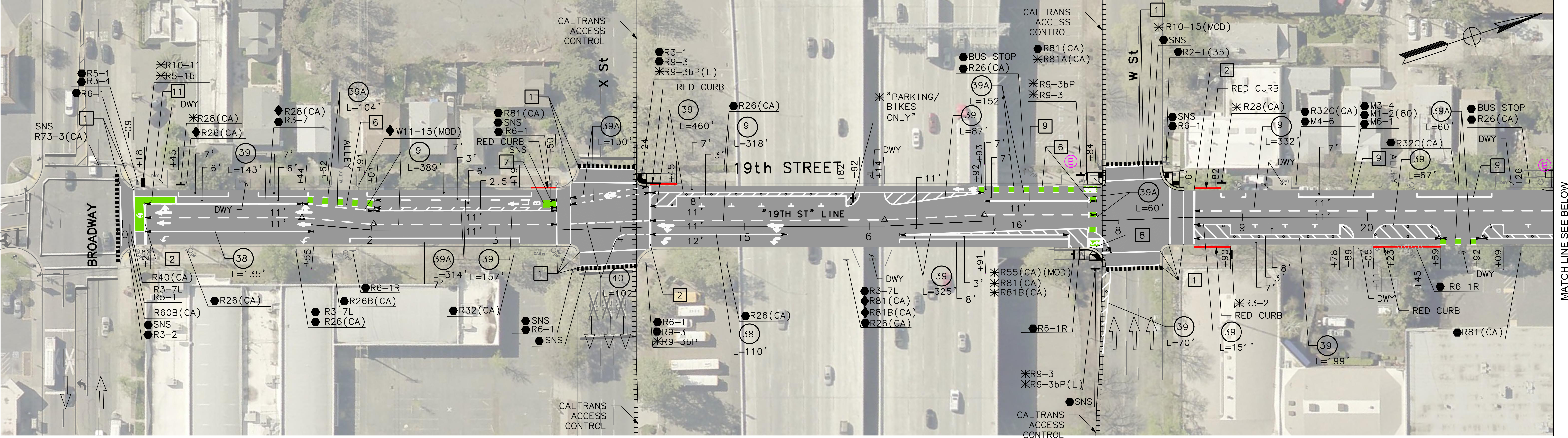
In the design diagrams, the transition appears to be at W Street, with no particular accommodation for bicyclists. Though the design diagrams do not indicate operations, just striping and signing, it looks as though bicyclists will cross W Street on the east side, with the regular signal, and then 19th Street on the south side, with the regular signal. There is no indication that the bicyclist crossing 19th Street will be protected from left turning motor vehicle traffic by an exclusive phase. Green paint is not sufficient communication for most drivers, hard physical control is required, such as no left turn during the bicyclist movement. I suspect, based on city implementation in other locations, that it was decided that an exclusive bicyclist phase was ‘not practical’ because it would slow motor vehicle drivers a bit.
19th Street from W Street to Broadway
I believe that the city should develop and install signing specifically for bicyclists on the transition points, where a bikeway either ends or transitions to the other side. There is no indication that the city has done or intends to do this. The diagram indicates a R55(CA) (MOD) sign on the southeast corner, which is a mystery, since the standard R55 sign is ‘yield to uphill traffic’. Of course neither the federal MUTCD nor the California CA-MUTCD, which is similar, has much in the way of guidance or signage for bicycle facilities, since in the mind of FHWA and Caltrans, bicyclists are an afterthought. There are several note references around this intersection, several of which I have been unable to locate in the design document, but they must exist somewhere. Be aware that the city has ‘invented’ a number of traffic control signs that are not compliant with CA-MUTCD, so the excuse that there isn’t an official sign is just stonewalling on the part of the city.
I Street
There has been no work on I Street in quite a while, since the resurfacing, but there are new ‘no parking’ signs posted with control starting today, 2023-09-19, so perhaps work is about to start again.
Concrete islands have been installed for the turn wedges at P & 21st, P & 19th, Q & 19th, and just today, at P & 9th and Q & 9th. The planned locations of these turn wedge islands are the intersections of the separated bikeways. The Q & 21st one is not installed yet, and I did not see any on 10th. The other intersections will have a different treatment, rubber speed bumps and vertical delineators.
The islands are centered by stamps red concrete. The curbs are four inches, and sloped at about 45 degree angle. Apparently these are poured on top of the pavement, I did not see any sign of excavation below the surface.
In a brief observation, about 20% of the turning drivers hit these islands. This is not surprising, as they are new, and drivers have gotten used to taking these corners at high speed, passing over what was just painted areas. I admit I almost hit one, as I had been riding straight through these intersections rather than swooping with the markings. But I pay more attention that most drivers, so I didn’t hit it.
Apparently the purpose of these is not to provide a wait area or bike box for bicyclists, but to slow drivers and have them pointing more perpendicularly to the bikeway and crosswalk, so they are more likely to see other people. But they do offer an area where bicyclists can get out ahead of and more visible to drivers.
concrete turn wedge island at P St and 21st St
Updates
P Street, Q Street, 21st Street: No significant changes.
19th St: Markings for the separated bikeway are marked from Q Street at least as far south as S Street. Not observed south of there.
I Street: No change, still just lane marking tabs. Paving was continued to 12th Street, so it is possible the project will be extended that far, but as designed, the separated bikeway and lane reduction ends at 15th Street.
10th Street: No significant change, is largely complete but some marking and delineators are still missing.
9th Street: I had speculated that the project would not be completed from L Street to Q Street, but it has been marked and partially painted now. There is a left side regular bike lane (two white lines but no buffer) from L Street to O Street, then mixed left side bike lane and separated from O Street to Q Street.
9th Street: 9th Street has a pavement overlay from L Street to Q Street. This is not repaving, removing old pavement and placing new, as has been done on many of the streets in the Central City Mobility Project, but a thin overlay. This was done very recently and there is no marking of any sort on the street. I had guessed that this section of 9th Street would not receive any treatment until the construction projects were complete, but I was wrong. I don’t know what kind of roadway allocation will be done in these five blocks. The left side is constrained by construction from L to Capitol Mall, and the right side from N Street to O Street and from P Street to Q Street. Note that in the photo below, there is a bus stop on the right hand side, which is why the city has designed the separated bikeway design on the left side.
9th St at L St, overlay and no markings
10th Street: 10th Street is largely complete from W Street to Q Street, where a pre-existing separated bikeway continues north, but a few things are left unfinished and not all of the green vertical delineators have been installed. The block from Broadway to X Street has been marked. It does not appear that anything will be done with the block from X Street to W Street, under the freeway.
10th Street from Broadway to X St, new markings for separated bikeway
I Street: Nothing has been done on I Street since the pavement patching. There are lane marker tabs for three general purpose lanes and no bicycle facilities.
19th Street: Work south of Q Street is now underway, with repaving complete and the beginnings or markings for the left side separated bikeway. I have not ridden south on 19th to see what is being done beyond this point.
19th St at Q St, initial markings for separated bikeway
There is no change to the ‘turn wedges of death‘. The bicycle signal at 21st Street and I Street has not been installed. No further work is in evidence on 5th Street.
I have been backpacking and traveling, so not keeping up as much with the Central City Mobility Project. I may do updates on my days back in town, about once a week.
19th St: Paint and vertical delineators are mostly complete from H St to W St. Nothing has happened in the two blocks from W St to Broadway. Though pavement has been patched from Q St to W St, no other work has occurred.
21st St: Paint and vertical delineators are complete from W St to I St. No bicycle signal at I St, so the intersection of 21st St and I St remains extremely hazardous to bicyclists (and walkers).
P St: Paint and vertical delineators are complete from 21st St to 15th St.
Q St: Paint is mostly complete from 14th St to 21st St. Vertical delineators have been installed on some blocks but not others, probably due to materials shortages. Some crosswalks are missing.
10th St: Paint is mostly complete from W St to Q St (Q St to I St was already ‘complete’ before this project). No vertical delineators yet. The block from Broadway to X St has a traditional bike lane on the right, but no changes. The block from X St to W St, under the freeway, has a wide right side shoulder, but it is not a bike lane, nor is it marked as such. The parking-protected separated bikeway on 10th St is on the right side, because 10th St does not have bus service to be accommodated by a left-side bikeway.
9th St: Other than some patching, nothing has happened on 9th St. The new bikeway from L St to Q St will be on the left side. A construction project from L St to Capitol Ave closes the left side bike lane, and there is no accommodation for bicyclists. Though there is a bus area on the right, followed by a parking lane, it is not marked as a bike lane, nor is it safe as a bike lane. There is no signed on 9th St approaching L St to indicate that the bikeway ends, nor how to ride south. See photo below.
9th St at L St, no bicycle accommodation
Another construction project from O St to P St closes the right side of the roadway, but the existing bike lane on the left hand side is still open. As previously noted, it is unlikely that the bikeway on 9th St will be installed until both construction projects are complete.
I St: Other than pavement patches, no other work has taken place. No-parking signs continue to be up even though no active work is occurring. Most blocks from 21st St to 12th St will be reduced from three general purpose travel lanes to two, but from 20th St to 19th St, and part way to 18th St, the three lanes will be retained. It is not clear why.
5th St: No further work has occurred.
Nothing has changed about the ‘turn wedges of death‘. A closer look at the design diagrams (thanks to the person who provided them) shows that the wedges at intersections of the separated bikeways are intended to have hard curbs, 4 inches with sloped sides (regular curbs are six inches or more) with stamped concrete interiors (style 3), but the other intersections will have ‘rubber speed bumps’, and vertical delineators. The bumps are apparently as shown in the photo below, though the photo shows a bump in the travel lane, and these are in the turn wedges. The bumps are 2.25 inches high, which won’t be even noticed by trucks and SUVs, though might be noticed and respected by passenger car drivers.
Apparently it does help to complain, at least sometimes. The city is fixing the root heave and gutter on 19th Street between Matsui Alley and N Street, which I posted on recently (hazardous bikeway on 19th St). I had submitted several 311 reports on this issue, and so had other people, and it seems we got through to Public Works.
The gutter is being replaced at the root heave, and other deteriorated locations in that half block. The photo below shows a night-time view, and I’ll add a daytime view and a view when the project is complete. Note that the bikeway is being appropriately diverted into the parking lane. It is unusual for the city to provide an equivalent accommodation for bicyclists.
gutter fix work on 19th St bikeway between Matsui Alley and N St
Of course there are several more blocks on 19th Street where the gutter pan is deteriorated enough that it doesn’t provide a bikeway surface and the bikeway therefore does not meet standards. However, this was the worst and most dangerous location, so there is progress.
I have mentioned the problems with the gutter pan on several blocks of the new bikeway on 19th Street being so deteriorated that the effective width of the bikeway is only about two feet. It is clear that the city did not look at the existing conditions of the gutter before deciding to place the bikeway in this gutter. But, this is not an easy thing to fix. There are at least four blocks that are unacceptable, but it will probably require reconstruction of the gutter pan to fix it.
What can be fixed, but has not been, is the root heave in the 19th Street bikeway at Matsui Alley (note that Matsui is discontinuous, and is present only on the west side of 19th Street; the alley does not exist on the east side.) The photo below shows the root heave, but doesn’t really emphasize how big it is. There is a four inch displacement. This is a pavement flaw that could easily cause a bicyclist to crash. I don’t know whether the orange paint marking is from the city or bicyclists, but orange paint is not visible at night, and even in daytime it doesn’t make clear what the rider should do to avoid the hazard.
19th St bikeway at Matsui Alley root heave
I have reported this issue to the city 311 app several times. I know of at least two other bicyclists who have reported it multiple times. The city 311 incident map shows only my latest report (230805-1907594), which means that the city has closed all the other reports without any action.
Allowing this type of hazard to exist, when it is a known hazard, particularly in a location designed to attract bicyclists, is criminally negligent. Let me repeat that for the idiots in Public Works, who seem to be hard of hearing – CRIMINALLY NEGLIGENT.
If you are a bicyclist who is using 19th Street, I encourage you to NOT use the bikeway in this block between Capitol Avenue and N Street. Ride in the middle of the general purpose travel lane instead. And if you have the time, file a 311 report on the hazard. It will become increasingly difficult for the city to claim it didn’t know about this problem (by closing the reports without action), the more people report it.