I live close to Fremont Park in Sacramento’s central city. I walk through the park every day I’m in town, often multiple times. That means I’m crossing through the bounding intersections of P Street & 15th Street, Q Street & 15th Street, Q Street & 16th Street, and P Street and 16th Street, multiple times a day. I also spend a lot of time at Naked Lounge on the southeast corner of Q Street and 15th Street, and some time at Karma Brew on the northwest corner of P Street and 16th Street. That gives me a front row seat to watching the behavior of drivers at these intersections. On nearly every signal cycle, I seem a driver running the red light at each of these intersections. This is not a the exception, it is the rule. By running the red light, I don’t mean entering the intersection on yellow and finishing on red, I mean entering the intersection on red. I mean drivers that are intentionally endangering themselves, other drivers, bicyclists, and walkers. Every signal cycle.
Though I’m an able-bodied and aware walker, Fremont Park is also used by a lot of homeless individuals, families using the playground, people sitting on the benches and reading, people lying on the grass and enjoying the sun (finally) and enjoying the shade (now), people participating in a number of organized recreation activities such as yoga, and of course the festivals such as Chalk It Up. This is a place that should be safe to get to for everyone. It is not currently.
I wrote about a crash at P Street and 15th Street. I’ve written multiple times about red light cameras, pandemic of red light running, red-light-running bullies, and SacCity red light cameras and crashes.
Let me state up front that I am NOT in favor of the enforcement of traffic laws by armed police officers. I have seen first-hand the way in which traffic stops are used to harass and oppress people of color and low income. I have read and seen innumerable accounts of officers murdering the people they stop on pretext. Armed law enforcement is the problem, not the solution. On the other hand, I am strongly in favor of automated enforcement. It is my theory that most serious traffic violations are by a small number of egregious drivers. Automated enforcement can ticket these drivers, which will change the behavior of some of them, but not of many of them who are high income drivers of high end vehicles. It does, however, allow law enforcement to identify repeat offenders and hold them accountable with vehicle confiscation and drivers license suspension.
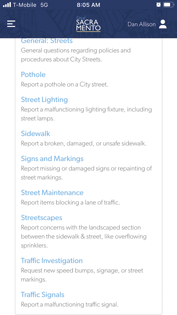
I want there to be red light enforcement cameras installed on at least one of the four intersections at Fremont Park. My observations indicate that the intersection of Q Street and 15th Street is the worst. I looked on the city’s Red Light Running Program page to see if there was a mechanism for submitting requests. No. I looked at the city’s 311 app to see if there was a place to submit a request. Not really. The closest I could find was to select Streets > Traffic Investigation, and then Signals (see screenshots below). I’ll update this when I get a response (though these days most 311 reports get no response at all).

The other way of request that might be effective is to directly contact city council members.