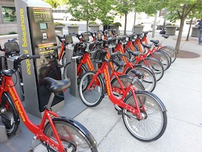
Another major happening this last week in Sacramento was the announcement of progress in bringing bike sharing to Sacramento.
Chris Morfas presented to the SACOG Bicycle and Pedestrian Advisory Committee on progress in bike share. Fehr & Peers is writing a business plan for the Sacramento Metropolitan Air Quality Management District. The business plan will include solutions for serving low income people and those without access to credit cards or smartphones (most systems depend on one or both of these to operate).
Participants in the annual Cap-to-Cap trip to Washington DC, hosted by Sacramento Metro Chamber, experienced the new and highly successful bike share program there.
The bike share business plan should be completed by mid-summer, and the partners will then seek capital funding from SACOG and possibly private investors. The Sacramento system might be integrated with the bay area systems now being designed, with the Amtrak Capitol Corridor being a logical connection between the two.
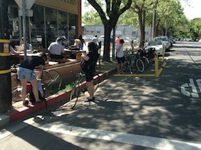
The bike parking corral at Insight Coffee on 8th Street is a great service to customers, but on nice days like we have been having, it is far too little. On Sunday morning, there were almost three times the bicycles parked around Insight Coffee as the 10-space bike corral could handle. There were bikes locked to parking meters and sign posts on both sides of the streets, and some bicycles simply unlocked for lack of a place.
We need more bike parking! Most customers are arriving by bike, few by car, at least when the weather is nice. It is a little hard to judge the number of customers by car on Sunday in this neighborhood, because car parking is filled with churchgoers for the churches to the south, and customers cannot park close to the business, but while sitting and watching for over an hour I saw only a few customers who seemed to be arriving by car. In contrast, there was a continuous turnover in the bicyclists, representing more than fifty customers in just an hour. And a lot of people arrived on foot, walking in from the neighborhood.
I am not being critical of Insight Coffee. They deserve praise for welcoming the Park-A-Bike demonstration bike corral, and for keeping it. I am pointing out that we have too little bike parking and too much car parking in downtown/midtown. Customers are coming by bike!
The other bike corral is at Pangaea Two Brews on Franklin.
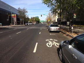
On I Street between 7th and 6th streets, there is a floating bike lane on the north side. A floating bike lane, also called a part-time bike lane, is one that is designed to be a parking lane for part of the day and a motor vehicle travel lane for part of the day.
The first photo below is the lane when parking is prohibited, and it is a shared motor vehicle travel lane. The signing indicates that parking is prohibited from 4 to 6PM on weekdays. This is in order to provide more lanes for the flush of traffic heading to the freeway during the afternoon rush hour. There are sharrow markings at the beginning and near the end of the block, to reinforce the “bikes may use full lane” sign (MUTCD R4-11).
The next photo shows the same floating bike lane when parking is allowed, the rest of the time. As you can see, the sharrows are partly covered by parked cars. The remaining width of the lane, which forms a de-facto bike lane, is too narrow for a lane adjacent to parked cars and is unsafe. In this particular location in front of the county jail, it is doubly unsafe because frequent turnover in cars (one hour limit) and the type of people who park here, not the sort to be thinking of bicyclists before they open their car door. In fact, guidance on floating bike lanes recommends against their use in situations with high-turnover parking.
I Street floating bike, parking prohibitedI Street floating bike lane, parking permitted (Elle Bustamante)
I never ride in this floating bike lane when there are parked cars, I always ride in the full travel lane to the left, but I often get honked at by drivers who think I should be in the “bike lane,” and don’t realize it is not a safe place to ride.
There is nothing inherently wrong with floating bike lanes. A number of cities use them in cases where they perceive a need to carry high volumes of motor vehicle traffic at certain times of day, but want to accommodate bicyclists at other times. They are always seen as a compromise that doesn’t make anyone completely happy. However, this is the only instance that I’m aware of in Sacramento, and it is not signed and marked in such a way as to communicate its purpose and use to either drivers or bicyclists. It needs to be crystal clear for everyone, or be removed. Maybe it is time for this floating bike lane to sink.
This section of I Street is the logical main access route for bicyclists to the train station. Rush hour for cars is also rush hour for bicyclists. What I see during this time of day (4-6PM) is a lot of bicyclists riding the wrong way, or on the light rail tracks, along H Street in order to access the train station. It is worrisome to me that that I Street was not designed with bicyclist safety in mind. Bicyclists feel that it is safer to ride against traffic on H Street than with traffic on I Street, despite the fact that wrong way riding is the leading cause of bicycle-motor vehicle crashes, or to risk spills getting caught in the light rail tracks, anything to avoid I Street. I have seen several bicyclists fall on the light rail tracks here.
I Street in this section could be made safe for bicyclists in two ways:
Remove parking from the left side of I Street and shifting travel lanes to the south so that a full 6.5 foot bike lane could be installed. The sharrows would not then be needed. Or,
Make the right hand lane a full-time parking lane and move the sharrows into the next travel lane to the left.
Given that there are bike lanes both east and west of this block, option one is probably the best because it would create a continuous bike lane, but option two is workable.
Thank you, Elle, for reminding me in your “transportation ‘planning’ downtown” that I wanted to write about I Street. Note: If you are looking at Google Maps, it does not show the current lane configuration on I Street since the repaving and re-striping project of last fall, nor the realignment of tracks and work on extending 5th and 6th streets over the tracks.
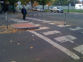
I Street from the 4th Street crosswalk; I have the walk signal but this is still scary
I Street in Sacramento approaching the train station is a mess. Starting with the confusing floating bike lane between 7th and 6th streets (subject of a future post), the street becomes worse and worse: five lanes wide, high speed, and completely unfriendly to bicyclists and pedestrians. For pedestrians, the crossing on the east side of the I/5th intersection is uncomfortable because westbound traffic is already moving at high speed and often runs the red light, and right turning cars from I to 5th often do not yield to pedestrians in the crosswalk. The west side is so unsafe due to traffic turning left off 5th Street, it is signed against pedestrian crossing, even though this is a logical walking route from downtown to the train station. A crosswalk has been added on the east side of the I/4th intersection, but it has the same challenges that drivers are moving too fast and often run the run light. When I used this new crosswalk, I was very concerned, and I have a much higher tolerance for danger than most people do.
The right-most two travel lanes lead to the high-speed northbound I-5 freeway onramp, so drivers passing 6th Street are already accelerating to freeway speeds, many times going 55 mph as they cross through the I/5th intersection. The next two lanes lead to a medium speed onramp to the I Street bridge over the Sacramento river, and to the southbound I-5 onramp. For pedestrians, the only way to go westbound towards Old Sacramento is to go through the parking lot for the train station and under the onramps along an ugly, dark, poorly marked pedestrian way.
My post on the new downtown bike lanes, shortly after the work was completed in fall 2012, had some mild criticism of the placement of sharrows. After many months of riding on these particular streets, and observing how bicyclists and motor vehicle drivers respond to their placement on the roadway, I am now prepared to criticize the sharrow placement more strongly.
The California MUTCD section 9C.07 specifies that shared lane markings (commonly called sharrows) must be at least 11 feet from the curb where parking is present. Either traffic engineers or paint crews, not sure which, are taking this to mean that the sharrows should be placed exactly 11 feet from the curb, as many of those in the recent Sacramento project were. The NACTO Urban Bikeway Design Guide has a better recommendation, “On streets with posted 25 mph speeds or slower, preferred placement is in the center of the travel lane to minimize wear and encourage bicyclists to occupy the full travel lane.” However, the NACTO guide has not been recognized or adopted by either the state or Sacramento, and in fact some vehicular cyclists are opposed to the NACTO guide because it promotes separate facilities over riding in traffic, but that is a conversation for another post.
One of the purposes of the sharrows is to guide bicyclists about the best place to ride in situations where bike lanes are not present and the lane is too narrow to share, 14 feet or less. When sharrows are placed to the side of the travel lane, they are too close to parked vehicles and their car doors. Doors on some two-door vehicles come out an amazing 54 inches from the side of the car. So if the side of a parked car is 7 feet from the curb, the door comes out 11.5 feet, more than the minimum specified in the MUTCD, and that does not even count handlebar width and shy distance. Eleven feet is not a safe placement. Many bicyclists know that this is not safe, and therefore ride in the middle of the travel lane, but since they are no longer riding on the sharrows, motor vehicle drivers think that they are riding in an illegal fashion and do the typical immature driver things: yelling, honking, following too close, and intimidation through close passing. Yet if the bicyclist is riding on the sharrows, then many motor vehicle drivers feel that there is room to squeeze by in the same lane, thereby coming much too close to the bicyclist and endangering them. The only safe place for the bicyclist to be is in the middle of the travel lane, and that is where the sharrows should be.
The first weekend in April is shaping up to be great fun for people like me who love themed slow rides.
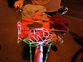
Friday, April 5th will be the next edition of BikeParty Sacramento, somewhere in the Land Park neighborhood. I participated in the March ride, whose theme was Massive Mural March, and it was a hoot. Many people came with highly decorated bikes, twinkly and sparkly and flashy, with fuzzy stuffed animals and fuzzy wild clothing. The murals scattered through midtown, some of which I’d seen before and many of which I had not, were entertainment enough, but the people themselves and their bikes were even better entertainment. Electroluminescent (EL) wired was common. EL is popular with the Burning Man crowd, and it is so cool, I just have to get some of my own. The photo is an EL rose designed and built freehand by the owner (whose name I’ve forgotten). The event is coordinated by Conrad, who rides and designs crazy art bikes.
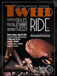
Saturday, April 6th will be the Tweed Ride, starting at Fremont Community Garden in midtown. Last year after a successful run, Rick Houston retired from sponsorship of the Sacramento Tweed rides, but Brian and Sarah have taken on the mantle are continuing under Sacramento Tweed Ride 2.0 (Facebook) and Sacramento Tweed (blog). Some people come dressed to the nines in 1920’s fashion, with tweed prominent, some people come with vintage bikes older than almost any of us, some people come with both, and many people come just because it’s fun and they want to find out more about it. For the last ride I went on, I rode my Brompton, which is not truly vintage but has a vintage British flavor, and wore my Victorian clothing, which is quite pre-1920’s, and was accepted in just fine. I hope to have some real tweed by the next ride.
These themed slow rides are a great way to socialize with the non-spandex crowd. They often include stops for coffee or beer or chocolate, and visit interesting places that you might not otherwise know about. Though I have an innate reluctance to ride in groups, as they introduce hazards that don’t exist for individual riders, these rides are so fun and such a positive experience that I’m willing to overcome my reluctance. The pace is such that anyone can keep up, on any kind of bike.
Unfortunately, the first weekend in April I am in the bay area for the Epicenter contra dance weekend in Mill Valley, and so will miss both rides. Hope you don’t miss them!
This weekend I was in the east bay. I normally switch over from Amtrak to BART at Richmond, and from BART back to Amtrak at Richmond at the end of my trip, but this weekend I had a much less tight schedule, so decided to pedal my way around. From the station, I headed south to the waterfront, looking for the San Francisco Bay Trail. Many of the streets in Richmond are seriously deteriorated, just as is true in all of the east bay, but some have been renewed. I picked up the trail, which winds for quite some ways along the edge of the bay, sometimes far from the freeway and city and quite pleasant. At Golden Gate Fields, the racing stadium, the trail seemed to disappear, or at least I couldn’t find it. Today I found some good maps online that would have gotten me around this gap, but not having them, I reverted to surface streets. Since this was also the point at which I noticed that the slow tire leak had turned into a fast leak, I pulled out my phone and located a bike shop to get it fixed.
Blue Heron Bikes on Gilman in Berkeley is a Brompton dealer, and turned out to be the perfect place to go. I got the tube replaced, and then decided to get my other tire replaced, as it was two plus years old and had been punctured so many times I could see daylight through it. The work was done with professionalism. Better yet, I had great conversations with shop manager Jeremy and owner Rob, about Bromptons and all kinds of other biking. A couple was also in, waiting patiently for Jeremy to finish with my bike, one a Brompton owner and the other soon-to-be Brompton owner, and it was fun talking to them as well.Read More »
Last night I used my BikeLink membership to store my bike at the Berkeley BikeStation, which is just two blocks from the Downtown Berkeley BART station. I was wandering around downtown in the late afternoon and early evening before going to a concert, and it was more convenient to be without my bike while walking, and then not having to negotiate to bring it inside at the concert. The BikeStation is a self-service setup, so you can put your bike in and get it out again at any time of day. The adjacent staffed BikeStation has weekday hours, but it doesn’t have to be open to use the storage.
BikeLink is a membership system. Storage costs about 3-5 cents per hour, often less at low-use times, so it is a very reasonable deal. To get started, you have to purchase the card for $20, though, and there is a $5 identification charge on first use. At any rate, $20 buys a lot of bike storage time.
I first wanted to use BikeLink one Sunday in San Francisco when I needed air for my tires and couldn’t find an open bike shop in the part of town I was in. I remembered that there was some sort of bike place at Embarcadero BART station, and so went there, but found it required that I have a card ahead of time. So I signed up and was mailed a card. I used it several weeks later to store my bike there at Embarcadero while attending the Climate Forward SF rally.
BikeLink also has storage lockers at a number of BART stations, other transit locations, and bike-heavy places throughout the bay area. I’ve not used these lockers yet.
BikeLink uses the same sort of electronic card as the ClipperCard transit system card which is now in use throughout nearly all of the bay area. Apparently there are discussions about merging the systems, or at least letting BikeLink credit be stored on the ClipperCard, but at the moment, they are separate.
I asked SACOG about whether the new ConnectCard (similar to the ClipperCard), which is being planned for the Sacramento region, would be able to use BikeLink as well. The answer was that the systems are theoretically compatible, but no plans for interoperability are in the works. I’ve heard that just getting all the transportation entities in the Sacramento region to agree on a common card has been a challenge enough.
I participated in the Walkable City live chat sponsored by Sacramento Press today, which featured Jeff Speck, author of Walkable City: How Downtown Can Save America, One Step at a Time, William Burg, and host Jared Goyette, which I advertised yesterday. I enjoyed hearing from both Speck and Burg. Burg is sort of the historian laureate of Sacramento, and his local perspective really added a lot.
You can review the recorded live chat by following the link from the live chat link above, and I highly recommend that you do. My take-aways from the conversation are:
Jeff Speck reiterated his “General Theory of Walkability” which defines a favored walk as including the elements of useful, safe, comfortable and interesting.
Speck said that in order to be walkable, a place must have “good bones”, short blocks in a grid pattern, with squares. Nearly always, these are pre-war neighborhoods. Burg pointed out that Sacramento downtown and midtown does have this, though our blocks are longer than many highly walkable cities, but our grid has been broken severely by the freeways and to some degree by the downtown mall and the convention center.
Speck said that many cities that have a great reputation for walkability started with just one great street, or even one great block, such as LoDo (lower downtown) in Denver. The one great place increased the draw for young creatives, which led to more widespread changes.Read More »
Sacramento Press is sponsoring a live chat with Jeff Speck, the author of Walkable City: How Downtown Can Save America One Step At A Time. The live chat is tomorrow, January 3, at 12:30PM. The offline chat is already going on, if you want to check it out. I am currently reading the book, in the Kindle version, but am only part way through.
Many of the online comments so far have focused on creating a livable city, and it is wonderful to see so many positive ideas and accurate identification of challenges. Intelligent conversation like this is rare in the Sacramento news blogs. I’ll make some comments specifically on the walkability safety aspects. I’ve written about this before, but it is worth writing about again and again, because the problems still exist.
Traffic sewers: Multiple lane and one way streets are traffic sewers. This epithet is used to describe streets designed to flush traffic in and out of employment centers (and to homes in the suburbs) twice a day. They serve no other reasonable purpose, and they make a place very much less walkable. Three (or more) lane roadways are incompatible with walkability. They encourage high speed traffic, and provide too long a crossing distance to pedestrians to be comfortable with. They don’t meet the “8-80” criteria, of being safe and comfortable for people of all ages.Solutions:
Therefore, I think that all three-lane roadways in Sacramento must be narrowed to two lanes. If a true refuge median is provided between two directions of travel, at least three feet wide, so that a person can cross each direction of traffic separately, then roadways with a total of four lanes are acceptable. If not, then only a total of two lanes. Six lane or more roadways, common in the northern and southern suburbs of the City of Sacramento, are not acceptable.
One way streets also encourage high speed travel. I think that all of our one way streets should be converted to two way streets. This can be done over time as streets are repaved, it is not as high a priority as the narrowing of streets, above.