Additional posts on Broadway Complete Streets are available at category ‘Broadway Complete Streets‘.
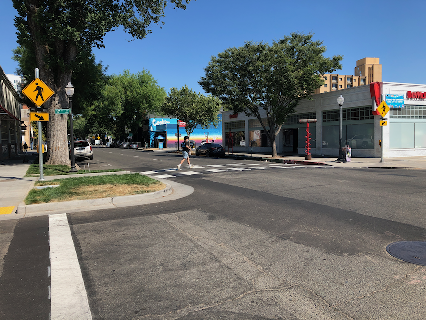
On Broadway eastbound at Land Park Drive, there is a bicycle signal face, shown below. The signal is permanently red, it never changes to green. The presence or absence of bicyclists makes no difference; it does not change from red. This is confusing both motor vehicle drivers and bicyclists. Bicyclists wait for it to change, and it never does. Drivers wonder why bicyclists are proceeded along Broadway with the green ‘car’ light when the signal clearly says that they should not be proceeding. I have seen drivers yelling at bicyclists for going when it is not their turn, and this has been reported to me by a number of people.
This issue has been reported to the city, twice by myself, and multiple times by other people. It has been this way for at least two weeks, perhaps longer. The city has decided to ignore these reports and to not fix the issue. The city is endangering bicyclists, and is in fact legally liable for knowing that a safety hazard exists and doing nothing to respond. This is criminal behavior on the part of the city. Sorry to be so blunt, but when city employees, or contractors acting on behalf of the city, ignore a known and easily solvable safety problem, that is criminal behavior. Period.
This would be so easy for the city to temporarily solve, by covering the bicycle signal face so that it is not visible. The pedestrian crossing sign over Broadway at the east side of the intersection is covered, due to the construction on the corner closing the crosswalk. Beyond a temporary fix, the city needs to determine why the bicycle signal face is not working, and make it work.
Yesterday a local politician spoke about how adding bicycle facilities to our roadways is what got us into the pavement condition crisis, implying that if we made bicyclists ride on sidewalks, everything would be fine.
My alternate title for this post is: ‘the pernicious arrogance of car drivers’.
There is a common belief that people driving cars are doing something important, and that people walking and bicycling are not doing anything important. It is true that this attitude is most prevalent in upper income white males, but it certainly exists to some degree with others. A related idea is that if you aren’t driving, you are poor, and its your fault, a very common bias against people who use transit. Bicyclists are most likely to come in for criticism because a common view is that bicycling is just for recreation, or for kids. All of this is wrong. It is not factual, and it is arrogant.
I do not drive. I haven’t owned a car in 13 years. When I started this blog, my tag line was (and still is) ‘BY FOOT, BICYCLE, AND PUBLIC TRANSIT (CAR-FREE!)’. I get everywhere by walking, bicycling and transit. I prefer walking, but bicycling and transit are useful when I need to get somewhere faster or a longer distance. It is true that I walk for pleasure most mornings, and ride for pleasure on occasion, but nearly all of my trips are purposeful. Yesterday I walked to the Chavez Plaza farmers market for some produce, then rode my bike to a public meeting, and then walked to have a beer. Today I’m walking to a meeting, and then riding my bike to Davis for the Davis Music Fest, and then taking the Capitol Corridor train home. When I do my grocery shopping, I walk or bicycle. When I go to medical appointments, I walk or bicycle. When I travel, I take the train, often with my bicycle, and then walk or bicycle or transit at the other end.
My trips are just as important as anyone driving a car. I am just as important as anyone driving a car.
Though I don’t want to overstate the case, my trips are actually more important in several ways. I am supporting a dense urban environment (I live in the central city) and the businesses and organizations located here. I am not endangering other people by my mode of travel. I’m a respectful bicyclist who always yields to walkers, which irritates the hell out of many drivers who have to wait while I wait for someone to cross the street. My walking and bicycling trips have almost zero carbon footprint, and my transit and train trips have a very low carbon footprint. I have never injured another person while walking or bicycling (though occasionally myself). I rarely take single-purpose trips, rather I chain errands.
I worked in the suburbs for many years. Three frequent driver behaviors I observed there that irritate me:
People drive from their work or house to get coffee, and back again. Just for a cup of coffee. It is true that the suburbs are a coffee desert, with few coffee shops and even fewer locally owned coffee shops. There are 12 local coffee shops within walking distance of where I live, and about 30 within bicycling distance.
People shopping at Trader Joe’s, and coming out with a small bag of groceries to their car. The groeries could easily be carried on a bike, and in many cases by walking. People seem to think that are doing good by shopping at Trader Joe’s, or Whole Foods, or Spouts, but the carbon impact of their driving trip undoes all the good of shopping there.
Parents driving their kids to school, and often pickup, when they live within easy walking or bicycling distance of school. I realize that it is not safe to cross many arterials, but rather than working to make things safe, or taking the time to go with their children, parents just default to driving without thinking about it.
This list could be very long, but the point is that people driving are NOT doing something more important than people walking and bicycling.
So why do people drive? Because we have built low-density places with destinations far away, so for many people driving seems the logical solution. Did we force people to prefer driving by making everything so far apart? Yes. Are people happy with this situation? Mostly not. Is there another way? Yes! Urban areas with moderate density allow people to make many trips by walking, bicycling and transit. It is time to stop the insanity, stop investing in long distance driving and commuting, and create places where everyone making trips will be seen as equal.
I was a strong supporter of RRFBs (rectangular rapid flashing beacon), where a safer crossing of the street is intended mid-block. I worked with transportation agencies in a number of locations to get them installed, and was very happy to see them go in.
They are used where multi-use trails cross roadways, and at intersections where additional traffic calming and safety are needed, but where the transportation agency does not want to add stop signs, or is unwilling or financially unable to install a traffic signal. The cost savings of an RRFB over a traffic signal are significant, about $25K for a RRFB, and upwards of $1M for a full traffic signal.
But…
Driver behavior has rendered RRFBs untenable for protecting people walking. I have observed a number of RRFB locations over the last few months. All of them are failing. Between 25% and 50% of drivers are failing to yield to people using these crossings, bicyclists or walkers. I have seen several people almost get hit by car drivers. Some drivers are slowing but failing to stop, or yield, and some drivers are not even slowing. Apparently the attitude of many drivers is that the RRFBs are only advisory and do not require yield to people in the street. Of course the law requires yielding to people crossing the street in a crosswalk, whether there is any type of signing or signaling, or not. But drivers don’t see it that way.
So, I find myself having to withdraw support for RRFBs. I will not support them as freestanding safety improvements, not as part of project. It is sad that driver behavior has erased the benefit of a safety enhancement, but it is a fact, and driver behavior gets continuously worse, never better.
Civic Thread has posted a petition to Caltrans, SACOG, City of Sacramento, and others in the region asking for immediate action to eliminate pedestrian and bicyclist fatalities. I encourage you to sign the petition, and to follow the efforts of Civic Thread and many other advocacy organization in holding government and particularly transportation agencies accountable for the traffic violence that impacts us all. As with everything that Civic Thread does, action is through an equity lens. It would be a great first step if every agency adopted the list of five commitments that Civic Thread says is required, though of course it is action and not language that will make the difference.
A commitment to work collaboratively and cross-sectorally at the City, County, and regional level to prioritize a consistent focus on equity and racial justice for project planning, funding, and implementation, particularly since evidence continues to show the majority of pedestrian and cyclist fatalities occur in low-income, communities of color, with Black residents disproportionately experience the highest risk of death while walking, in addition to a high risk of being killed by police in routine traffic stops.
A commitment to prioritize funding mechanisms and set aside funding within the city, county, regional, and state budget for active transportation programs, Safe Routes to School, and matching funds for state and federal funding programs at the local jurisdiction level.
A commitment to thoroughly vet community proposed infrastructure recommendations and to work closely with neighborhood groups and residents to identify solutions and ideas the community supports, including roaddiets, speed reduction, and quick builds along High Injury Networks.
A commitment to analyze current roadway conditions, transportation design policies, and guidelines and develop a plan to address design flaws equitably and immediately.
A commitment to building a comprehensive, seamless, low-stress network of active transportation corridors that is centered on equity and prioritizes investment in low-income and environmental justice communities.
Note: I’ve added text and a photo of the approach from the north.
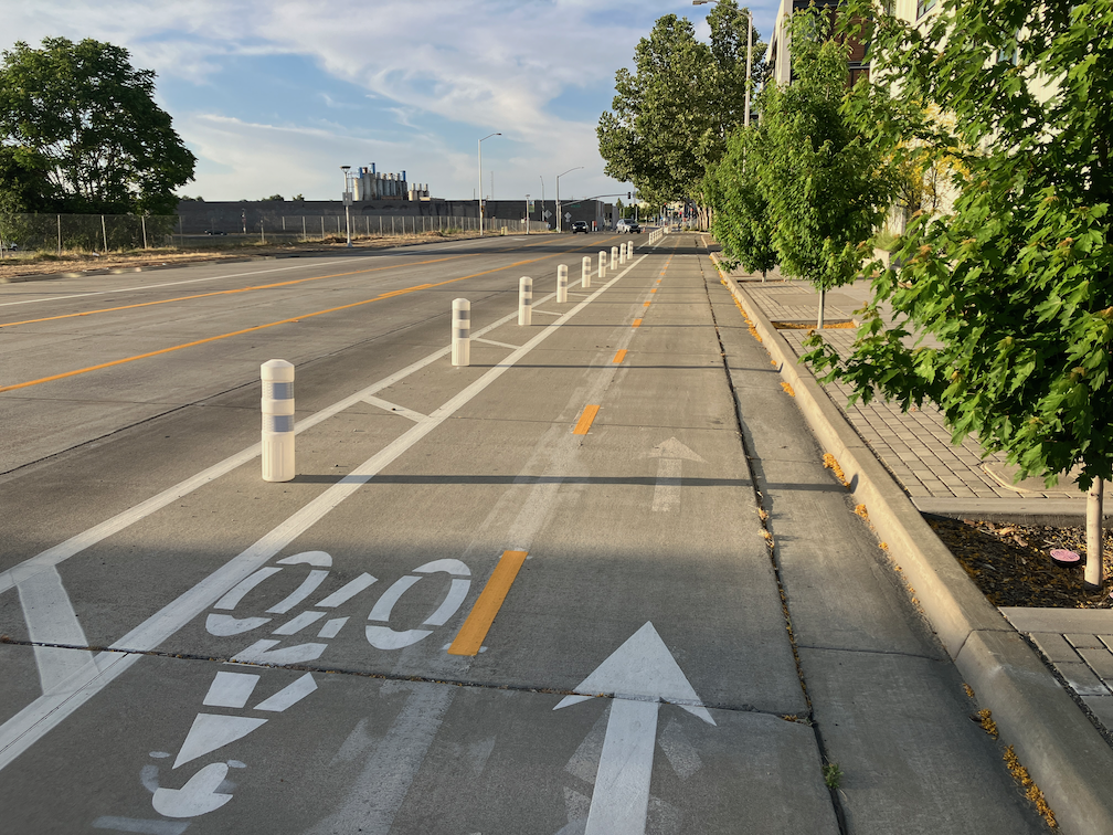
The City of West Sacramento has installed a section of cycletrack (a two-way Class 4 separated bikeway) on South River Road and 5th Street in the Bridge District. Apparently completed late 2023 (shows how long since I’ve ridden that way), it is part of the Riverfront Street Extension and 5th Street Widening Project.
From 15th Street (the connection to Jefferson Blvd) north to almost Mill Street, the bikeway is separated from motor vehicles by a hard curb divider. The on-street bike lane southbound still exists, but this bikeway provides a much safer alternative. The onramp to Hwy 50 east (or Business 80 as it is designated), was an extreme hazard for bicyclists due to drivers turning at high speeds. See two photos below.
South River Rd cycletrack / separated bikeway at 15th StSouth River Rd cycletrack / separated bikeway
From Mill Street north to Bridge Street, the cycletrack is separated by a buffer and vertical delineators (K-71). At Bridge Street and north, the roadways returns to traditional Class 2 unprotected bike lanes. Though it would have been great to extend the curb-protected cycletrack all the way north to West Capitol Avenue, at least the truly dangerous section at the freeway onramp was fixed.
To the south of 15th Street, South River Road has more traditional bike lanes, with buffers in a few locations, as it crosses the ship channel and goes through two roundabouts.
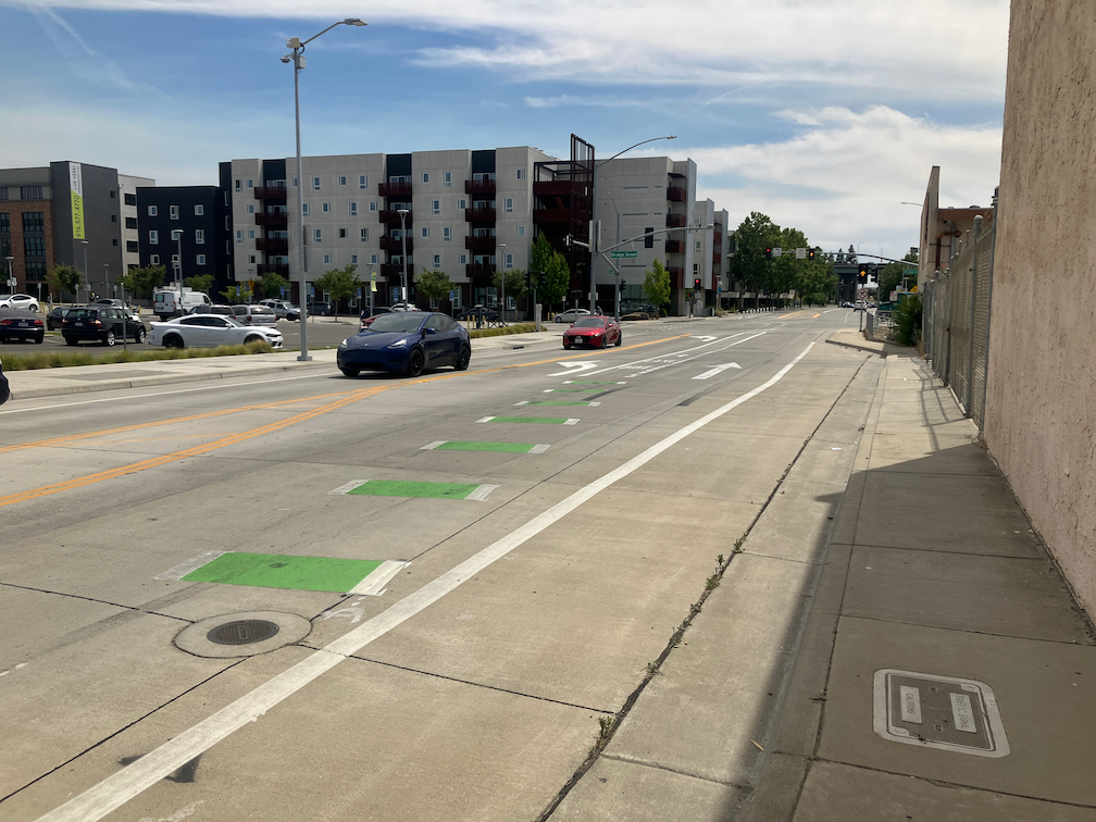
The transitions to and from the bikeway seem a little awkward as they swoop through the intersection, but are probably not unsafe. I observed several bicyclists heading westbound to 15th Street who were not following the skip green bicycle markings, but the maneuver was not unsafe. I did not observe any bicyclists at the Bridge Street intersection.
Approaching the cycletrack from the north, the southbound traditional bike lane on the west side of 5th Street transitions to the cycletrack on the east side of 5th Street at Bridge St. Though the transition does not feel safe, I think it actually is, with signals preventing inappropriate motor vehicle movements.
5th St bike lane transitioning to cycletrack approaching Bridge St signs and signals for bicyclist on 5th St at Bridge St
The city has proposed a Folsom Blvd Safety Project. See previous post on that project. I would like to present an alternative to the bicycle facilities aspect of this project, improvement of the M Street corridor. M Street, and related streets including Elvas Ave, provide an alternative route. This route is already used by hundreds of bicyclists per day, students at Sacramento State, other commuters, and recreational bicyclists accessing the American River Parkway. Folsom, on the other hand, sees very little bicycle use. This is because it feels dangerous for most bicyclists, and because it is not the most direct route for many destinations.
The lack of bicyclists does not indicate that the street does not deserve bicycle facilities. Folsom has no bicycle facilities in the section to be revised, does not feel safe for bicyclists, and is not safe for bicyclists. The classic saying is that you can’t judge the need for a bridge by the number of people swimming the river. Bicyclists deserve safety on every street.
However, since bicycle facilities are a primary feature of the project, so it is worth asking: ‘Is this the best investment of limited funds?’ I’d suggest that upgrades to the M Street corridor might be a better investment.
Neither route actually offers safe access to and through Sacramento State. M Street is a low volume, mostly low speed street, from Alhambra Blvd to Elvas Blvd, However, the section along Elvas to the Hornet Tunnel that goes under the railroad tracks, is hazardous and intimidating for bicyclists. Folsom Blvd, with this project, would provide basic bicyclist facilities from Alhambra to 65th Street. However, access to and through Sacramento State beyond 65th Street is poor. The ‘safer’ crossing of Folsom at 69th Street and Elvas Avenue is awkward, was designed for walkers and not bicyclists, and not really safe. I have observed a number of drivers blowing the red light at this crossing. After crossing Folsom, a bicyclist can jog west to Elvas Avenue, and ride that to Hornet Tunnel, though the street is very deteriorated, of widely variable width, and the entrance to the tunnel is awkward.
The map below shows both routes, M Street from Alhambra Blvd to Elvas Avenue, in orange, and Folsom Blvd from Alhambra Blvd to 65th Street. Both are of equal length. Folsom Blvd has bike lanes from Alhambra to 47th Street, and discontinuously from 49th Street to 57th Street, with nothing to the east. M Street does not have bike lanes, but is is a low volume, low speed roadway along which most bicyclists feel comfortable riding. It is a ‘low stress bikeway’. Some of the route is marked with bike sharrows. Though improvements could certainly be made to M Street, it is functional as is, as a bicycle route.
Folsom Blvd has a posted speed limit of 35 mph, and much higher speeds are routinely observed. The fatal crash was in fact due in part to egregious speed violation by a driver. The proposed project would reduce speeds somewhat due to prudent drivers, but will probably encourage passing in the center turn lane. The project would leave the posted speed limit unchanged. M Street has a posted speed limit of 25 mph throughout, and speeds above 30 mph are rare. Would bicyclists rather ride on a non-bicyclist facilities roadway with 30 mph traffic, or on a buffered and un-buffered bike lane with 50 mph traffic?
Both of these routes are unacceptable because they don’t create a safe corridor all the way to Sacramento State. However, I feel that an investment in improving the M Street corridor section along Elvas would be a better investment than bicycle facilities along Folsom Blvd which end at 65th Street.
I wrote about improving the section of the M Street corridor between 62nd Street and Hornet Tunnel earlier this year: Elvas Ave and Hornet Tunnel. I don’t have a cost estimate for this project.
I am not saying the the Folsom Blvd Safety Project is a bad idea, just raising the question of where funds can be best invested to improve safety and comfort for bicyclists.
The section of Elvas Avenue between 62nd Street and Hornet Tunnel which leads to Sac State is very dangerous for bicyclists. Bicyclists have to transition across four lanes of traffic (three travel lanes and a center turn lane), without any protection whatsoever. The pavement quality is low, particularly on the east side where the ‘bike lane’ (not a real bike lane) is. Despite this, it is a high-use bicycle route from Sacramento to Sac State and the American River Parkway trail. M Street, this section of Elvas, and the Hornet Tunnel serve as a bicycle boulevard (though not designated) between the central city, Sac State, and beyond.
Since the day I arrived in Sacramento and rode my bike to work in the eastern suburbs, I have known that this section needs to be fixed. It took me 12 years to get around to writing about it. I hope that it will take the city less to fix it. The solution presented here is not the only solution, so I encourage others to comment, point out flaws, and suggest optimal solutions.
Elvas Avenue is a high-speed, moderately high-volume roadway that acts in many ways as an expressway due primarily to the turns from Elvas Avenue to 65th Street, and from 65th Street to Elvas that encourage high speeds. The roadway is dangerous for motor vehicle drivers and passengers as well as bicyclists. North of 62nd Street, St. Francis High School (about 1100 students) suffers from traffic risk created by Elvas Avenue, so traffic calming to the south will benefit the high school as well as bicyclists. It might be appropriate to extend the separated bikeway north to the signalized crosswalk over Elvas to the school.
The City of Sacramento does not make available to the public an inventory of sidewalks. The city does make available on the Transportation & Infrastructure page: Bike Master Plan, EV Chargers, Off-Street Parking, Signs, Street Lights, Traffic Counts, and Traffic Signals, and other datasets. Sacramento County makes available on the Transportation page: Posted Speed Limits. SACOG makes available on the Transportation page several other transportation datasets. None have sidewalk inventories.
I have heard, unofficially, that the city has a partial dataset of sidewalks, but it is not spatially complete. It may be that it has only more recent installations, or that it focuses on some parts of the city. I have done a PRA for sidewalk inventory, but the city couldn’t figure out what I was asking for, so I will have to determine how to describe the dataset in a way they will understand.
What would a good sidewalk inventory contain?
total width
unobstructed width
sidewalk buffer (planting strip) width
available right-of-way
condition
year of installation, or reconstruction
gaps
intersection corner design
ramps (compliant or not)
The soon to be adopted 2040 General Plan 8-Mobility Element mentions sidewalks a number of times, suggesting widening or improving. Probably the most important are:
M-1.9 Equitable Processes and Outcomes. The City shall ensure that the transportation system is planned and implemented with an equitable process to achieve equitable outcomes and investments so that all neighborhoods one day will have similar levels of transportation infrastructure such as sidewalks, marked low stress crossings, and bikeways.
M-1.14 Walking Facilities. The City shall work to complete the network of tree-shaded sidewalks throughout the city, to the greatest extent feasible, through development project improvements and grant funding to build new sidewalks and crossings, especially within the high-injury network, in disadvantaged communities, near highridership transit stops, and near important destinations, such as schools, parks, and commercial areas. Walking facilities should incorporate shade trees.
However, there is no mention of how locations needing improvement will be identified. Is this guesswork on the part of city staff, or is there a dataset being used but not shared with the public?
My request is that the city make available to the public whatever sidewalk inventory it has, even if it is not spatially complete nor has all the elements a sidewalk inventory should have.
A sidewalk inventory is the first step in meeting the city’s goal of a continuous, high quality sidewalk network. More about that soon.
deteriorated sidewalk on 24th St, near Capitol Ave
And while we are at it, a crosswalk inventory:
marked or unmarked
width
length
design
median island
material: paint or thermoplastic
condition
date of placement or refresh
traffic control (yield, stop, signal, actuated crossing)
crossing prohibition
It should be said that sidewalks and crosswalks in the City of Sacramento are in better condition than many similar sized cities in California, but that does not mean that there isn’t a need for great improvement. Every city and county neglects its sidewalks.
The League of Women Voters Sacramento sponsored an online Climate Justice Mayoral Candidates Forum on Monday, January 22. Thirteen local climate and transportation advocacy organizations co-sponsored. Seven questions were asked of the five candidates (Jose Avina, Flo Cofer, Steven Hansen, Kevin McCarty, and Richard Pan). You can view the forum on YouTube.
Questions asked:
In 2019, the city council adopted a resolution declaring a climate emergency, committing to carbon neutrality by 2045 and to accomplishing as much action as feasible by 2030. Would you modify these dates, and if so, how would you do it?
Sacramento is getting hotter each summer, with more and longer heat waves. Other extreme impacts of climate change include flooding and stronger winter storms. These conditions impact our residents and especially our most vulnerable communities and the unhoused. How can the city do better in addressing these impacts for all residents of Sacramento?
Mayor Steinberg has proposed a countywide ballot measure that would establish a one and a half cent sales tax (incorrect) for an integrated approach to housing, safe and complete streets, transit, and climate innovations. Would you support such a measure in 2026? Why or why not?
Transportation is by far the greatest contributor to greenhouse gas emissions in our region. It is critical that we improve our public transit system and increase ridership. What role do you see the city and mayor playing in making this happen. What type of innovative transit projects would you seek to prioritize, and please include in your answer, the last time you used public transit.
The Mayors Climate Commission completed its work in 2020, and provided comprehensive recommendations for achieving carbon zero by 2045. Many of these recommendations are included in the city’s proposed Climate Action and Adaptation Plan which is scheduled for adoption this spring. The proposed plan has a price tag of over $3 billion, yet the city does not have funding set aside for this purpose. What would you do to ensure that funding and financing are addressed in a meaningful way so that the plan does not sit on the shelf?
Sprawl development continues throughout the region and contributes to increased vehicle miles traveled and greenhouse gas emissions. For example, massive development is proposed for the Natomas basin north of downtown. What is your view on annexing city and county boundaries to facilitate this type of development? How do you balance the arguments that these developments would create new jobs and bring in revenue with the need to prevent further emissions-producing sprawl and encourage infill and urban development?
Active transportation options, walking, cycling and rolling, play an important role in reducing greenhouse gas emissions as well as improving health and quality of life. Safety is a reason often cited for not using these options. What can the city do to improve safety, provide additional opportunities, and encourage and incentivize active transportation?
As a strong believer in bike share, I note Steve Hansen’s reply that promoted bike share.
“I helped work with the city of Davis, West Sacramento, and the City of Sacramento through SACOG to launch our shared mobility program. Our JUMP system before the pandemic before the pandemic hit was as successful as the City of Paris, and what happened, though, is after it was sold to Uber and then Lime, disinvestment happened. We need to get back to likely a publicly owned system where we have connectivity.“
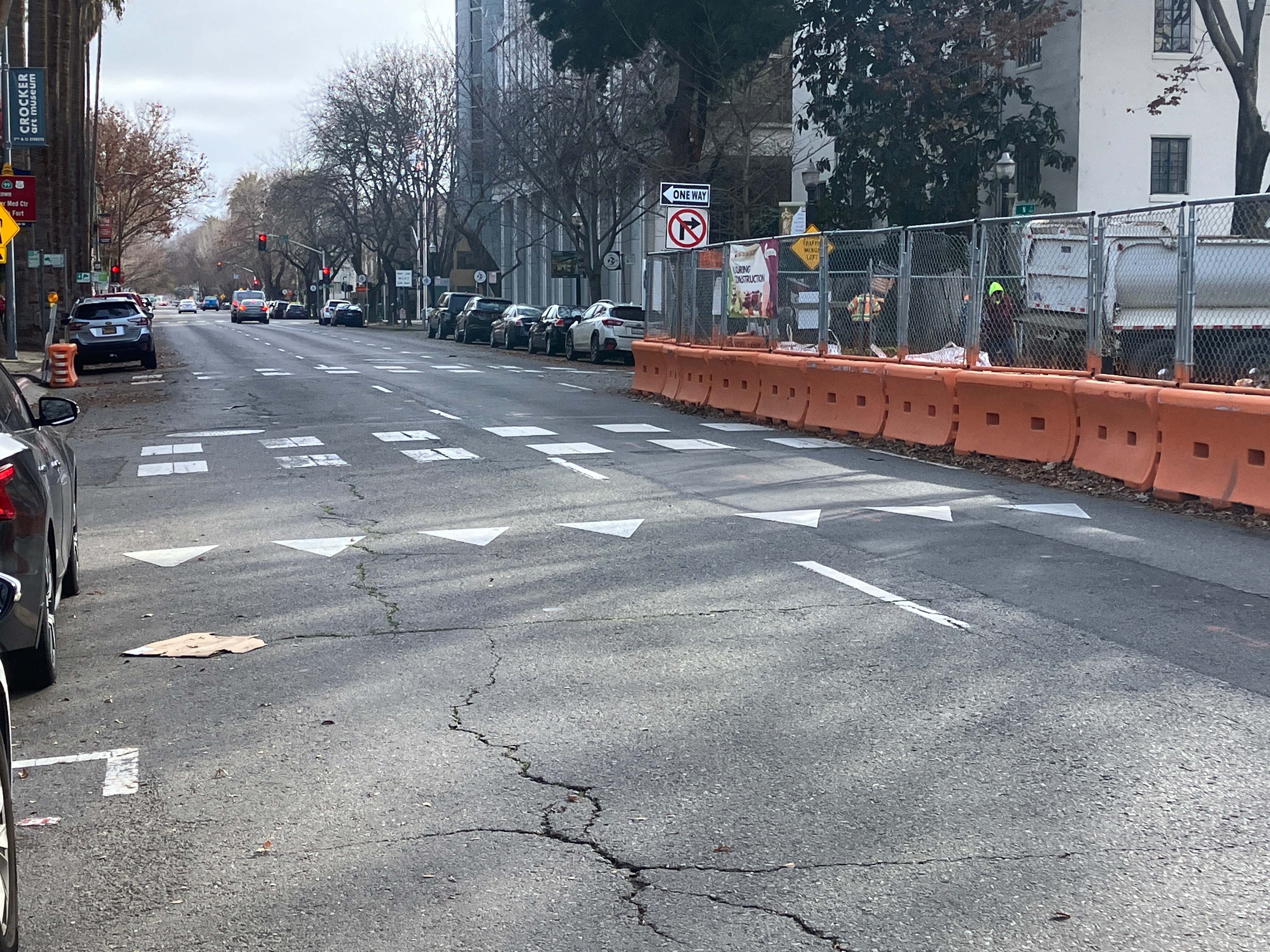
At a recent meeting, people asked me about the crossing of N Street at 14th Street, what I thought of the pedestrian prohibition, and why I hadn’t reported it as I do most other construction related issues.
N Street is a three lane one-way street, reduced to two lanes by construction at the state capitol, and the CADA construction project on the southwest corner of N Street and 14th Street. At this construction project, the parking lane and rightmost lane are closed, with a barrier and fence along N Street. The barrier and fence block driver view of the crosswalk on the east side of the N Street/14th Street crosswalk, until just before the crosswalk. This is a situation not addressed by CA-MUTCD, nor the proposed city Draft Criteria and Guidance to Accommodate Active Transportation in Work Zones and at Events, or work zone guide for short.
There are probably ways of safely handling this limited visibility situation, but it is not immediately obvious to me how. So I have not reported the closure of this crosswalk. It is a low volume crosswalk, I believe. Any detour for walkers is an issue, and this one requires a detour of a block to the east or west, because both the east crosswalk and the west crosswalk are closed.
While it is true that this crosswalk closure is no absolutely necessary, it is also true that it would take some sort of traffic control at this location to make it safe for walkers.
N St approaching 14th St, poor visibilityclosed crosswalk over N St at 14th St, east leg, northeast cornercrosswalk closed over N St at 14th St, east leg, southeast corner