Central City Mobility update

This is Central City Mobility Project update #21.

I have been backpacking and traveling, so not keeping up as much with the Central City Mobility Project. I may do updates on my days back in town, about once a week.

19th St: Paint and vertical delineators are mostly complete from H St to W St. Nothing has happened in the two blocks from W St to Broadway. Though pavement has been patched from Q St to W St, no other work has occurred.

21st St: Paint and vertical delineators are complete from W St to I St. No bicycle signal at I St, so the intersection of 21st St and I St remains extremely hazardous to bicyclists (and walkers).

P St: Paint and vertical delineators are complete from 21st St to 15th St.

Q St: Paint is mostly complete from 14th St to 21st St. Vertical delineators have been installed on some blocks but not others, probably due to materials shortages. Some crosswalks are missing.

10th St: Paint is mostly complete from W St to Q St (Q St to I St was already ‘complete’ before this project). No vertical delineators yet. The block from Broadway to X St has a traditional bike lane on the right, but no changes. The block from X St to W St, under the freeway, has a wide right side shoulder, but it is not a bike lane, nor is it marked as such. The parking-protected separated bikeway on 10th St is on the right side, because 10th St does not have bus service to be accommodated by a left-side bikeway.

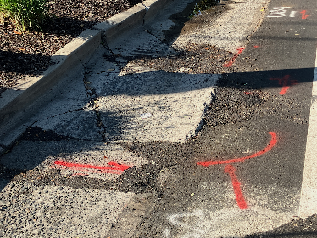
9th St: Other than some patching, nothing has happened on 9th St. The new bikeway from L St to Q St will be on the left side. A construction project from L St to Capitol Ave closes the left side bike lane, and there is no accommodation for bicyclists. Though there is a bus area on the right, followed by a parking lane, it is not marked as a bike lane, nor is it safe as a bike lane. There is no signed on 9th St approaching L St to indicate that the bikeway ends, nor how to ride south. See photo below.

9th St at L St, no bicycle accommodation

Another construction project from O St to P St closes the right side of the roadway, but the existing bike lane on the left hand side is still open. As previously noted, it is unlikely that the bikeway on 9th St will be installed until both construction projects are complete.

I St: Other than pavement patches, no other work has taken place. No-parking signs continue to be up even though no active work is occurring. Most blocks from 21st St to 12th St will be reduced from three general purpose travel lanes to two, but from 20th St to 19th St, and part way to 18th St, the three lanes will be retained. It is not clear why.

5th St: No further work has occurred.

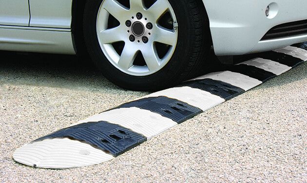
Nothing has changed about the ‘turn wedges of death‘. A closer look at the design diagrams (thanks to the person who provided them) shows that the wedges at intersections of the separated bikeways are intended to have hard curbs, 4 inches with sloped sides (regular curbs are six inches or more) with stamped concrete interiors (style 3), but the other intersections will have ‘rubber speed bumps’, and vertical delineators. The bumps are apparently as shown in the photo below, though the photo shows a bump in the travel lane, and these are in the turn wedges. The bumps are 2.25 inches high, which won’t be even noticed by trucks and SUVs, though might be noticed and respected by passenger car drivers.

9th St bikeway finally open again

The parking-protected, separated bikeway on 9th Street between K Street and L Street is finally open again, 2-1/2 years after it was closed for construction conversion of the Capitol Park Hotel by Mercy Housing. Though the area was occasionally used for active construction, mostly it was used for long-term storage of construction materials.

The sidewalk is still not open.

9th St separated bikeway K to L reopened

19th St gutter fix

This is Central City Mobility Project update #20.

Apparently it does help to complain, at least sometimes. The city is fixing the root heave and gutter on 19th Street between Matsui Alley and N Street, which I posted on recently (hazardous bikeway on 19th St). I had submitted several 311 reports on this issue, and so had other people, and it seems we got through to Public Works.

The gutter is being replaced at the root heave, and other deteriorated locations in that half block. The photo below shows a night-time view, and I’ll add a daytime view and a view when the project is complete. Note that the bikeway is being appropriately diverted into the parking lane. It is unusual for the city to provide an equivalent accommodation for bicyclists.

gutter fix work on 19th St bikeway between Matsui Alley and N St

Of course there are several more blocks on 19th Street where the gutter pan is deteriorated enough that it doesn’t provide a bikeway surface and the bikeway therefore does not meet standards. However, this was the worst and most dangerous location, so there is progress.

hazardous bikeway on 19th St

This is Central City Mobility Project update #19.

I have mentioned the problems with the gutter pan on several blocks of the new bikeway on 19th Street being so deteriorated that the effective width of the bikeway is only about two feet. It is clear that the city did not look at the existing conditions of the gutter before deciding to place the bikeway in this gutter. But, this is not an easy thing to fix. There are at least four blocks that are unacceptable, but it will probably require reconstruction of the gutter pan to fix it.

What can be fixed, but has not been, is the root heave in the 19th Street bikeway at Matsui Alley (note that Matsui is discontinuous, and is present only on the west side of 19th Street; the alley does not exist on the east side.) The photo below shows the root heave, but doesn’t really emphasize how big it is. There is a four inch displacement. This is a pavement flaw that could easily cause a bicyclist to crash. I don’t know whether the orange paint marking is from the city or bicyclists, but orange paint is not visible at night, and even in daytime it doesn’t make clear what the rider should do to avoid the hazard.

19th St bikeway at Matsui-Alley root heave
19th St bikeway at Matsui Alley root heave

I have reported this issue to the city 311 app several times. I know of at least two other bicyclists who have reported it multiple times. The city 311 incident map shows only my latest report (230805-1907594), which means that the city has closed all the other reports without any action.

Allowing this type of hazard to exist, when it is a known hazard, particularly in a location designed to attract bicyclists, is criminally negligent. Let me repeat that for the idiots in Public Works, who seem to be hard of hearing – CRIMINALLY NEGLIGENT.

If you are a bicyclist who is using 19th Street, I encourage you to NOT use the bikeway in this block between Capitol Avenue and N Street. Ride in the middle of the general purpose travel lane instead. And if you have the time, file a 311 report on the hazard. It will become increasingly difficult for the city to claim it didn’t know about this problem (by closing the reports without action), the more people report it.

parking and bikeways

A number of people have commented, here and other places, that my idea of converting parallel parking to diagonal parking is wrong. There should be bike lanes instead. These comments come from a misunderstanding of context. I’ve written some while ago about diagonal parking, and it is mentioned in many of my posts about parking and street design, particularly sidewalk-level bikeways and bike lane widths.

What I intend is a transportation system where:

  1. Streets designed for 20 mph and under don’t need any bike facilities, as they are naturally traffic calmed. Bike lanes would be a waste of space. Where these streets are too wide, diagonal parking is a great solution for narrowing the street.
  2. Streets from 21 to 30 mph need standard Class 2 bike lanes. Visual separation from motor vehicles is needed.
  3. Streets from 31 to 40 mp need separated bikeways. In most cases these should be at sidewalk level, not at street level, but street level bikeways can be a temporary measure until the street is redesigned. These bikeways need to be sufficiently wide to accommodate passing and all types (widths) of bicycles and mobility devices.
  4. Streets 41 mph and above are NOT streets, they are roads, and should be designed as such. No driveways, no street facing retail or commercial, few intersections. These are for getting someplace fast. These roads do not need bicycle facilities at the edge of the road. What is needed is a completely separate transportation system that keeps bicyclist safe and completely separated from motor vehicle traffic.

Is any of this real right now? No. Nothing like this exists in the Sacramento region. But I strongly believe it is the goal we should be moving towards, with haste. And diagonal parking on slow but overly wide streets provides traffic calming and more efficient use of space.

real turn wedges

This is Central City Mobility Project update #16.

A post today on Streetsblog LA (Santa Monica’s New 17th Street Curb-Protected Bike Lanes are Amazing) is about new bicycle facilities on 17th Street in Santa Monica. I think you will find some of the photos interesting. At first glance, it looks like some of the ones being installed as part of the Central City Mobility Project, but looking more closely, two differences really stand out. Most of the separated bikeways in Santa Monica are curb-protected. Bikeways that are solely parking protected only are protected when cars are parked. Otherwise, they are really just buffered bike lanes. And the turn wedges are hard curbs with additional markers, not paint-only, and definitely superior to the Sacramento’s suggested turn wedges which might have vertical delineators or other markers, but won’t have curbs.

curb turn wedges in Santa Monica (from Streetsblog LA)

To illustrate the problem these curb turn wedges solve, see the photo below of a motor vehicle making a high speed dangerous turn over a painted parking wedge at P Street and 15th Street.

16th St & P St, Sacramento, high speed turn across painted turn wedge

Other

  • P Street markings including green paint are nearly complete. In two blocks, the green paint is nearly the entire block, for unknown reasons. There is nothing unique about these blocks. While green paint is useful to mark conflict areas, excessive use will just lead to maintenance expense over time.
  • Q Street has preliminary markings, but the temporary lane tabs still indicate overly wide and dangerous general purpose lanes.
  • 19th Street is nearly complete from H Street to Q Street, but there is no marking south of Q Street. South of Q Street, the old bike lanes show in some places, but otherwise have been erased in favor of overly wide and dangerous general purpose lanes. Several blocks of the new bikeway are in the gutter pan, making an unacceptable rough and dangerous surface.
  • 21st Street is complete except for a few spots that were missed and have not been picked up. The confusing arrow at 21st Street and W Street has been corrected. There is still accommodation or signal for bicyclists at 21st Street and I Street.
  • I Street work has begun, with the last few ADA ramps complete and some repaving.
  • 10th Street has the last few ADA ramps complete.
  • 9th Street doesn’t have any work in evidence.
  • 5th Street has not progresses past installation of signal bases.
  • Overall, no vertical delineators have been installed at any locations.
  • Delivery vehicles are parking in and blocking the separated bikeway on P Street approaching 16th Street. The city did not mark any of the parking spaces for delivery use. Cones and barricades have been placed in the buffer to reduce this hazardous driver behavior, and have been removed by someone, and replaced by citizens, and removed by someone, and …

bikeways in Seattle

I was in Seattle in May, for Northwest Folklife, and am back again at the moment, reminded that I had not posted about transformations happening in Seattle. Seattle is, on the whole, a very traffic-y city with sparse bike facilities, but what is interesting is what they are doing with re-allocating roadway space to better use than motor vehicles. Bus lanes, wider sidewalks, protected bikeways, removal of parking. It is inspirational.

I have not been able to pin down whether it is official policy, but I can say for certain that the city is no longer installing paint-only door-zone bike lanes. Anywhere. All of the bike facilities are separated, some by car parking, some with planters, some with substantial vertical delineators. Almost all the new ones are either at roadway level and protected by hard curbs, or raised to sidewalk level and therefore separated from the roadway by curb and buffer strip.

Read More »

turn wedges of death

This is Central City Mobility Project update #15.

I have been following the progress of the Central City Mobility Project which has now mostly completed separated bikeways on 21st Street, half of 19th Street (H to Q), most of P Street, and now going to Q Street. One of the features of the design is ‘turn wedges’ which I have written about before: where the bike lane ends – update, where the bike lane ends, Central City Mobility update. I have spent a lot of time observing driver and bicyclist behavior at the intersections which have these turn wedges installed. The wedges are marked only by white paint, though city diagrams show them having some sort of physical barrier installed in them.

Drivers are using the turn wedges, and the buffer areas of the separated bikeway, to make very high speed, very wide turns at these corners, cutting the corner where a bicyclist might be riding. The prior configuration of a regular intersection did not allow such wide and high speed turns. I have seen a number of close calls between motor vehicles and bicyclists, and walkers, for that matter, since these high speed turns cross the crosswalk as well as the bikeway. These turn wedge corners are also encouraging drivers to run red lights, even more so than the usual red light running. I saw three drivers run the red on a single signal cycle, and a driver on the cross street had to slam on their brakes to avoid a collision. I’ve seen a large number of near-misses for motor vehicles.

It is not clear whether these turn wedges are complete or not. Will the city actually install something here that prevents or at least discourages these high speed dangerous turns? I don’t know. What I do know is that in the meanwhile, these turn wedges are a clear and present danger to bicyclists.

I spent time this afternoon watching left turns from P Street westbound to 15th Street southbound. Drivers were using the buffer area and the bikeway to form two lines of left turning traffic, where there should be only one. The block of P Street was completely devoid of parked cars, so drivers were queuing into two lines way back near 16th Street. Since the intersection is in no way marked for a double left turn lane, there were motor vehicle conflicts on every signal cycle.

Sorry to be the doom-sayer, but I have to recommend that bicyclists simply not ride on these streets until the projects are truly complete, with as full a protection for bicyclist as can be achieved with these less than international best practice designs.

The city’s attitude seems to be that since the bikeways will eventually be safer, we just have to put up with the unsafe situation in the meanwhile. I completely disagree. This may be criminal behavior on the part of the city, to remove moderately safe bike lanes and replace them with unsafe bikeways. If bicyclists (or walkers or drivers) die before the project is complete, is this just a ‘whoopsie’? Professional engineers designed this project, signed off on this project, and should be inspecting the project as it goes along. Why do we then have these unsafe situations? Is is intentional? Is it indifference to bicyclists and walkers? Is it professional incompetence?

It is imperative that all construction projects accommodate walkers and bicyclists, who are even more vulnerable at these projects than normally. The attitude of ‘it will be safer later’ is completely unacceptable.

The construction company for this project is McGuire and Hester. Though many people might blame these problems on the construction company, I don’t. It is the city’s responsibility to design safe projects, during and after construction, and it is the city’s responsibility to inspect projects to see if they are complying with the design, and to fix things if not. But I strongly suspect that the construction company is doing exactly what the city told it to do.

21st St and T St turn wedge

bicycling at 21st St & I St

This is Central City Mobility Project update #14.

When bicyclists using the separated bikeway on 21st Street come to I Street, they are left without any bicyclist facilities at all, in a hazardous situation. The city intends to install a bikes-only signal here to allow bicyclists to proceed when motor vehicle traffic is not moving, but until at least late July, bicyclists are on their own. See the previous posts where the bike lane ends – update and where the bike lane ends for background.

The city has recommended, in the information sign on 21st St approaching I St, that bicyclists cross I Street using the pedestrian signal. I recommend otherwise. The double left turn general purpose (motor vehicle) lanes from 21st Street northbound to I Street westbound encourage drivers to make high speed turns, with no attention to other roadway users, while the pedestrian signal shows the white walker. This was a serious problem before the reconfiguration of 21st Street, but now is worse because not only are walkers are endangered, but now bicyclists as well.

I recommend looking for gaps in traffic from 21st Street southbound (21st is two-way north of I Street with much less traffic and much lower speeds) and I Street westbound (I Street to the east is a two-way street with much less traffic and much lower speeds), and cross against the red light. Illegal, yes. But safer to be making an illegal move than competing with drivers turning left on the green light.

This intersection could be made safer in the meanwhile by two city actions: 1) Create a separate phase for walkers crossing I Street on the west leg, where the signal remains red; and 2) Prohibit left turns on red at the signal. Since this is a one-way street to one-way street turn, it is legal to turn on red, unless posted otherwise. The advantage to prohibiting left turn on red is that it will allow bicyclists to only pay attention to two opposing traffic movements rather than three. It will be necessary to prohibit left turns on red when the bike signals are installed, so why not do that now? There is a ‘left turn yield to pedestrians’ sign here, but it is small and mounted high up, so unlikely seen by drivers. Drivers may reasonably expect walkers crossing at slow speed, but are not expecting bicyclists crossing at much higher speed. It’s why bicyclists are discouraged from riding crosswalks, and why the city is wrong to be encouraging such behavior here.

21st St & I St bicyclist crossing sign

Sac Public Works enemy of safe streets

At the June 15, 2023 meeting of the City of Sacramento Active Transportation Commission meeting, agenda item 5 was ‘Stone Beetland Planned Unit Development – Amendments to the Bicycle Master Plan’. The topic was about modifying the bicycle master plan so that the new bicycle facilities in this development connected with other facilities already in the master plan. But since it is the purview of the commission is to address all active transportation topics, several members of the public and of the commission asked questions and commented on the transportation aspects of the overall development plan.

I asked why the streets were so wide, ranging from 42 feet to 74 feet, with the most common being 59 feet. Wide streets encourage drivers to speed, and so are significantly less safe than narrow streets. Another commenter and two commission members also asked about this. A 42 foot right of way should be the upper limit of street width, not the lower limit. When asked, the developer said that they had wanted narrower streets, but City of Sacramento Public Works forced the wider streets. The excuse from Public Works was apparently that as the area developed, there would be more traffic and wider streets were necessary. This is a self-fulfilling prophecy: building wider streets induces more traffic, and so the wider streets are needed to handle the motor vehicle traffic that the wider streets induced.

There were other questions about this development, including whether streets will have sidewalk buffers of sufficient width to host trees as they mature, and whether bicyclists will be able to leave the neighborhood since Cosumnes River Blvd is a high speed (55 mph!), high volume arterial that has paint-only bike lanes (which should not even be legal on a road with 55 mph posted speed limit), that very few bicyclists feel comfortable riding on. No matter what bicycle facilities the developer provides, people will be trapped in their neighborhood, unless they can drive and want to drive.

Public Works is the enemy of safe streets. Again and again the safer streets proposed by city planners and developers are nixed by someone in Public Works. There are car-brained engineers in Public Works that think the sole purpose of streets is to carry the maximum number of motor vehicles at the maximum possible speed. Despite the world changing around it, and the clearly documented hazard of wide fast streets, Public Works is living in the past, dedicated to a cars-first transportation system. I am not denying that there are progressive people in Public Works, and in Community Development as well, but somehow the outcome is always worse and less safe than the public wants.

Stone Beetland development 74 foot wide street