Is law enforcement the answer?

From my post on Vision Zero and law enforcement, it might be assumed that I think increased enforcement is the answer. I’m not so sure. The problem is that law enforcement in general, and traffic enforcement specifically, has long been used as a tool by law enforcement to harass and oppress people of color, low income people, and the homeless. As a white male, or course, I don’t experience this, but I certainly observe it happening to others. I see it in Sacramento, I see it everywhere I travel. It is part of the purpose of law enforcement to maintain privilege for those in power. And it can, and does, also protect people. But the privilege function seems to me to overwhelm the protection function. It is certainly true that people of color and low income, and the homeless, do not trust law enforcement officers, because they have long been victims. Having a tail light out, which results in a stop, and frequently a search, and sometimes brutality, and sometimes even death, does not lead anyone including me to think that simple enforcement is a solution to traffic violence. And yet, ignoring the real threat of traffic violence, which affects people of color, low income, and homeless, far more than people of privilege, is not a solution either.

So, what to do?

Automated speed enforcement (ASE) is part of the answer. Cameras don’t racially profile, and assuming that there is no bias in sending tickets, does not oppress. The city has included a recommendation for ASE in the Vision Zero Action Plan: 3.4 Support state Automated Speed Enforcement legislation. Of course speeding is much better controlled by street design, but ASE can contribute to a reduction in the number and severity of collisions, particularly during the long period of time it will take to fix our unsafe streets.

I have a theory that most traffic violations, at least the ones likely to result in fatality and severe injury (KSI), are the result of what I call egregious violators, those who continuously and flagrantly violate the law. These are the ones that are not going 30 in. 25 mph zone, but going 50 in a 25. If ASE can catch these drivers, and eventually remove them from the road, I would expect a great decrease in KSI.

Another solution is to prevent law enforcement from using stops as a pretext, for the purpose of racial profiling. A stop should be just a stop, dealing with the violation and no more. That will take a change in law enforcement policies and attitudes, and probably changes in law that restrict officers in what they can do on traffic stops. When traffic stops shift from low riders to Escalade drivers, we will have made some progress.

Another solution, one implemented in some European countries, is that a traffic violations of safety significance results in a ticket whose amount depends on either the value of the vehicle or the income of the driver, and is not a flat rate. Standard violation fees, with court and processing costs added on, are a huge burden to many lower income people, while high income people hardly notice. If you don’t think that income matters, look at parking violations. Many higher income people routinely get parking tickets, every day, but it does not change their behavior, they see it just as part of the cost of getting the best parking spot and keeping it.

To implement Vision Zero in Sacramento, the community is going to have to talk about how law enforcement has long affected people of color, and continues to. We are going to have to come up with solutions that reduce and eliminate the effects of profiling based on race, income, and housing status, and the disparate impact of tickets on different income levels. I don’t have the answers, but I have faith that the WHOLE community does.

What do you think?

Vision Zero and traffic enforcement

Sacramento essentially has no traffic enforcement currently, which has led to significant increase in:

  1. running stop signs (not talking about illegal failure to come to a complete stop, but running at full speed or slowing only slightly)
  2. failure by drivers to yield to pedestrians in the crosswalk (actually in the crosswalk, not just waiting to cross).

If these issues of non-enforcement and encouragement of unsafe behaviors is not addressed, the Vision Zero effort will fail, no matter what other actions are undertaken.

I have been watching patterns of driver violation in the central city for seven years, as my profession provides me the interest and skills, while my sense of preservation as a pedestrian gives me the motivation. I can state unequivocally that both violations have increased significantly over that time. While it once felt safe and even a bit welcoming to walk in the central city, it does no longer. Why? That is harder to say, but I think that the lack of enforcement of these laws by the Sacramento Police Department has contributed to the problem. Drivers know they won’t be held accountable for failure to yield, and so they don’t. Of course a few do, but with drivers in the other lanes on multi-lane one way streets failing to yield, pedestrians are at just as much risk as if no one yielded.

I have been wanting to delve into traffic enforcement data for the City of Sacramento and all other locales in the region, but that is a major undertaking I haven’t gotten to. A sampling of data below will provide some context. Traffic stop data for years prior to 2016 is not available online, so I can’t speculate about trends in the data.

California Vehicle Code (CVC) “22450. (a) The driver of any vehicle approaching a stop sign at the entrance to, or within, an intersection shall stop at a limit line, if marked, otherwise before entering the crosswalk on the near side of the intersection.”

Using data from Sacramento Traffic Stops, 2016 had 30001 stops, 2432 of which were for 22450, 8.1%. 2017 had 32267 stops, 2642 of which were 21950, 8.2%. Stand on any single corner in the central city, and you could see this many violations in a day. Clearly, this law is being only lightly enforced.

CVC “21950: (a) The driver of a vehicle shall yield the right-of-way to a pedestrian crossing the roadway within any marked crosswalk or within any unmarked crosswalk at an intersection, except as otherwise provided in this chapter.”

Using data from Sacramento Traffic Stops, 2016 had 30001 stops, 66 of which were for 21950, 0.22%. 2017 had 32267 stops, 43 of which were 21950, 0.13%. Stand on any single corner in the central city, and you could see this many violations in an hour. Clearly, this law is not being enforced.

Vision Zero comments

Here are my comments on the draft Vision Zero Action Plan for Sacramento. Most of these were posted on the boards at the 2018-01-31 meeting, and in email to the city.

  • Sacramento essentially has no traffic enforcement currently. More about this tomorrow.
  • I was concerned by the prominence of the bicyclist fatalities increasing 150% without any contextual information. As with any data point with small numbers, as bicyclist KSI (killed and severely injured) is with respect to pedestrian and vehicular KSI, noise can lead to apparently huge changes that may not indicate a pattern. It would be sad if that one statistic were used to argue that changes to protect bicyclists should be prioritized, when it is clear from all the other data in the plan that pedestrians are at the greatest risk.
  • If 78% of KSI occurred at intersections, issues can be addressed more quickly and cheaply by focusing on intersections rather than corridors.

Profiles

All profiles should have the DAC/CES overlay, not just profile 3.

  • Profile 1: unsafe speed and profile 3: 35+ streets: Street Narrowing should say Street Narrowing and Speed Limit Reduction
  • Profile 4: 30+ streets should include lane narrowing
  • Profile 5: broadside: is there evidence that adding signals reduces crashes, anecdotal evidence would argue that it increases crashes
  • What does no bullets for efficacy mean, that there is no benefit, or that there is insufficient research?

I asked about why there was a 30+ and a 35+ profile. The answer is that collision characteristics change considerably between 25 and 35, with 30+ being an issue for bicyclists, and 35+ being an issue for all modes.

Vision Zero Actions (p. 45-50)

  • 1.5 Launch online, interactive crash data map and website. > short-term
  • 2.2 Install 10 low-cost safety improvements, including new road markings, signs, and minor signal modifications per year. > 10 locations
  • 2.3 Develop prioritized list and deliver half of engineering safety projects on the HIN in Disadvantaged Communities (commensurate with share of fatal collisions). > separate so that list is short-term, deliver is long-term
  • 4.4 Install school zones at all schools. > what about reductions at qualified locations?
  • 5.4 Update City signal timing policy to improve safety for all modes (e.g. all red time, pedestrian crossing times). > should include specific mention of LPI at high-pedestrian or high-collision intersections

Bike share…

I can’t believe that governments are allowing and even encouraging use of these for transportation, without regard to local communities and the damages they suffer. Problems include:

  • parking in inappropriate places
  • parking for free with no regard for other people’s use of the public domain
  • blocking pedestrian right-of-way
  • terrorizing pedestrians on the sidewalk
  • leaving them in yards where they are an unsightly mess
  • abandoning them to collect dust and spider webs
  • they routinely get vandalized and stolen
  • lazy people use them for ridiculously short trips
  • there are far, far more of them than can be justified by the number of users
  • the environmental impacts of production and end-of-life cycle are being ignored
  • huge corporations with deep pockets, particularly from the Far East, are largely responsible for this mess
  • they are completely out of reach for many low-income people
  • a clear sign of rich people invading historic neighborhoods – gentrification!

No, no bike share, cars!

Yes, snark. These are all criticisms that that being routinely made of bike share systems, with no apparent sense of irony.

Sacramento Vision Zero and Bicycle Plan meeting January 31

You might have thought you had other plans for the evening, but…

The City of Sacramento is holding the last of four public meetings on Vision Zero and Bicycle Master Plan implementation tonight, January 31, 5:00 to 7:00PM at city hall.

You can see the new Bicycle Master Plan and draft implementation plan at http://bit.ly/SacBicyclingProgram. You can see the Vision Zero Draft Action Plan and other documents at http://bit.ly/VisionZeroSac.

Just one of these would be reason to attend, but both! Hope to see you there.

Driving a stake through LOS

The Governor’s Office of Planning and Research has completed the first step in replacing level of service (LOS) with vehicle miles traveled (VMT) as the primary measurement for determining the CEQA impact of development on roadways by drafting the replacement language. This process was specified in In the second step, the Natural Resources Agency is holding a public process to implement the changes, and you can participate. Two meetings have been scheduled:

Sacramento
Date: March 15, 2018
Time: 1:30-4:30pm
Location: California Energy Commission, Rosenfeld Hearing Room
1516 9th Street, Sacramento, CA 95814

Los Angeles
Date: March 14, 2018
Time: 1:30-4:30pm
Location: California Science Center, Annenberg Building, Muses Room
700 Exposition Park Dr, Los Angeles, CA 90037

You can also comment by email at CEQA.Guidelines@resources.ca.gov.

I hope that you will support the changes either in person or by email. The use of LOS has caused incalculable damage to roadways and to livability throughout California. CEQA, originally intended to protect the environment, as been used instead as a weapon to harm the environment and encourage sprawl. Urban infill could rarely meet the requirements of LOS in CEQA, but suburban development almost always could, so what we got is square miles of suburban and exurban sprawl, and very little infill. This change to VMT will at least level the playing field, and may make sprawl more difficult. I don’t know how much opposition there will be, but there are several interests that would like thing to stay just the way they are: engineers who want to build highways instead of transportation systems, greenfield developers who make huge profits while shifting costs to society, and cities and counties (you, Sacramento county, and others) who want to preserve their ability to encourage and subsidize far-flung development. If you like cities, if you like livability, if you like infill, this is one of the most important things that can happen.

Of course, this is only the second step in driving a stake through the heart of LOS. The third step is to ensure that all cities, counties, and regional agencies remove LOS as a tool in planning development and transportation. The legislation and these regulations will prevent exclusive use of LOS by any entity, but it does not preclude use of LOS as a additional criteria. LOS must be eliminated completely. The most important question in transportation and development is what kind of world we want to live in, and though VMT is only a tool for achieving that, it is far far better than the tools we currently use.

For all the details of the Natural Resources Agency process and regulation, see the CEQA page and the notice of rulemaking.

Curb extensions 16th & N

Curb extensions, also called bulb-outs, have been installed on all four corners at the intersection of 16th Street and N Street in midtown Sacramento. The extensions are the width of the parking lanes along both these streets. N Street has bikes lanes, which are not restricted by the extensions, while 16th Street does not have bike lanes, and won’t until the street is reconstructed into a more complete street at some unknown point in the future.

The primary beneficiaries of curb extensions are pedestrians, who have a shorter distance to cross, with every crossing being about six feet less distance for every parking lane, so in this case, 12 feet less. There is also much better visibility of cars by walkers, and of walkers by car drivers. Sometimes they also provide an opportunity for beautification, with rainwater swales and/or planting, as can be seen in the photo.

Every street with parking lanes should have curb extensions, so almost every intersection, but implementation will be slow because they are moderately expensive to construct (curbs sidewalks, detectable warning strips, better located ped buttons), and sometimes require drainage changes and occasionally even utility relocation. These particular extensions are certainly not the first in Sacramento, in fact there are extensions on the west corners of the intersection of 16th and O, just to the south, but are notable for being installed in a high pedestrian use area along two heavily trafficked streets.

J Street Safety Improvments

The City of Sacramento is going to use street rehabilitation funds (from SB-1) to create a separated bikeway on J Street between 19th and 30th, starting this summer. The city held a public meeting last night (January 25) to gather public comments on the design elements, which have not been finalized.

I like the proposal, and see it as a significant improvement over what is there now. The general purpose travel lanes would be reduced by one, from three to two, while bike facilities would be increased from zero to one. The separated bikeway, also called a cycle track or protected bike lane (separated bikeway is the correct term in California) would be installed along the right side of the one-way street. The project will improve pedestrians safety by shortening the crossing distance over general purpose lanes, but this is more a traffic calming and bike facility project than a pedestrian project. This project is intended to be a “paint only” project that fits with the funds available. Improvements needing concrete would come later, if at all. The separated bikeways would be “protected” with flexible delineator posts between the parking lane and the bikeway, which provides increased safety but not full protection.

Though the diagrams shown last night indicate that bus stops would be at the existing curb, and the bikeway with green paint would swing around the bus stop to the left, it appears that the city is rethinking that and will use a shared bus/bike lane for the length of the bus stop. There is talk of moving bus stops to better locations, and perhaps reducing the number of stops for better service times. The only bus currently using J Street is SacRT Route 30, which has a 15 minute frequency on weekday day times, 30 minute evenings and Saturdays, and 60 minute Sundays. This is a route whose ridership probably justifies 10 minute frequency day times.

The intersections will be daylighted by removing the parking spaces that currently are right up against the crosswalks and reduce visibility between drivers and pedestrians. I completely support that and feel that the safety benefits make the loss of a few parking spaces worthwhile. I’m not against on-street parking, in fact I like it because it slows traffic, but safety is even more important.

I would like to recommend some improvements to the project as presented:

  • Reduce lane widths from 11 feet to 10 feet. This is the most important action that could be taken to enhance safety. The best action for pedestrian and bicyclist safety is to #SlowTheCars (@StrongTowns). The narrower the lanes, the slower the traffic, and the slower the traffic, the less severe collisions that do occur, and the less collisions. The city currently has an 11 foot standard they don’t seem ready to change, but what better time than now to create a significant project with narrower lanes, so we can directly experience the safety benefits.
  • Reduce the speed limit to 20 mph, and stripe the street in a way that encourages this actual speed. Again, the city is reluctant to go below 25, but there is a growing national movement to 20 mph in urban areas. Goes hand-in-hand with the lane width reduction, and is very inexpensive to implement.
  • Stripe the separated bikeway and street in such a way that the shared bus/bike lane at bus stops can be converted to floating bus islands with the bike lane at the curb. This configuration keeps the bus in the flow of traffic, which greatly speeds bus times as they don’t have to wait for a gap in traffic to continue. I do not know how wide the islands need to be to accommodate bus shelters, but am looking into that and will report. Another advantage of the lane width narrowing is that it would provide another two feet for the islands. The separated bikeway “lane” is seven feet, and that seems fine to me. Since this is a “paint only” project, concrete bus islands would delay it for additional finding, which I don’t want to see, but the design should be ready for bus islands as soon as they can be funded.
  • Reduce the number of bus stops to one every three or four blocks. The increase in service speed makes the greater walking distance worthwhile, and since the walking environment will be more appealing and safer, this is a good trade-off.

The meeting last night was the only formal opportunity to have input to this project, but I encourage you to email Jennifer Donlon-Wyant with support for the project, for these improvements I’ve presented, or you own ideas. You can also comment here, but emailing Jennifer is the first step.

Bike share and bike racks

The announced JUMP bike share coming to Sacramento (Sacramento, West Sacramento and Davis) is fuzzy on details. The announcement says “SACOG and the cities of Davis, Sacramento, and West Sacramento are currently permitting the bike share hub locations and are beginning public engagement.” The implication is that the system will be dock-optional, with hubs located in common areas and a small fee for not parking the bike at a hub, just like the existing SoBi Tower Bridge Bike Share Preview. However, the two existing JUMP systems, in Washington DC and San Francisco, are truly dockless, not dock-optional. There are no hubs, at least so far, though SF is considering some hubs to encourage people to leave the bikes at charging stations.

The JUMP bikes are of the same basic design as the SoBi bikes, they have a GPS unit and a locking U-bar that is meant to lock to bike racks or other fixed objects. Many other bike share systems such as LimeBike have a self-locking wheel lock (like European bikes), and cannot be locked to a rack. The Zagster system I used in Ashland is a hybrid: there is a cable for locking to a hub, which the bike must eventually be returned to, and another cable for locking to racks or other objects when stopping off as part of an errand trip.

When I used JUMP bikes in SF last weekend, one end of my trips had ample bike racks, but the other end did not. At the far northern edge of the geofenced system area, in a residential neighborhood, I searched four blocks without finding a bike rack, and finally used a post that was not a good location as it may have partially blocked access to a building and to parking spots. It was only there for about 20 minutes, so I felt OK, but it really brought home that a dockless system that requires bike rack use, as does the JUMP system, needs ample bike racks to work.

In the Sacramento central city, some areas have ample bike racks, but many areas, particularly neighborhoods to the east, and state building and office building areas, do not. So if the Sacramento system is to be dockless, and if it is to be successful, the city will have to install many more bike racks, in a hurry. West Sacramento and Davis probably have a similar need, but I’m less familiar with them.

My suggested criteria for bike racks is that one or more be visible when standing on a corner at any intersection, anywhere within the service area. I think electric bikes can be a great substitute for ride hailing (Lyft and the company that shall not be named), and a great complement to transit, but only if a person can find a bike close to their origin, and leave it close to their destination.

Jumping ahead (bike share update)

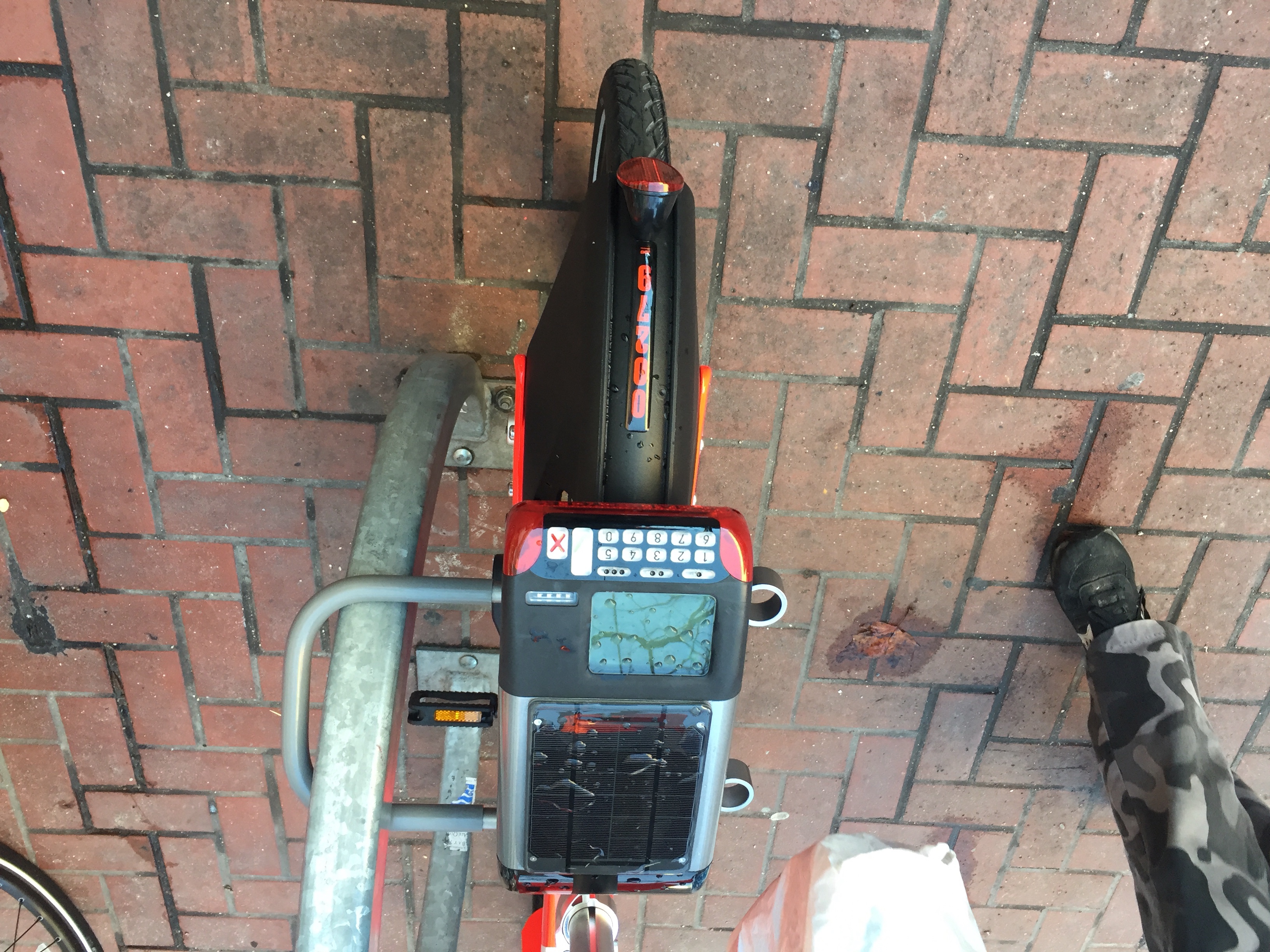
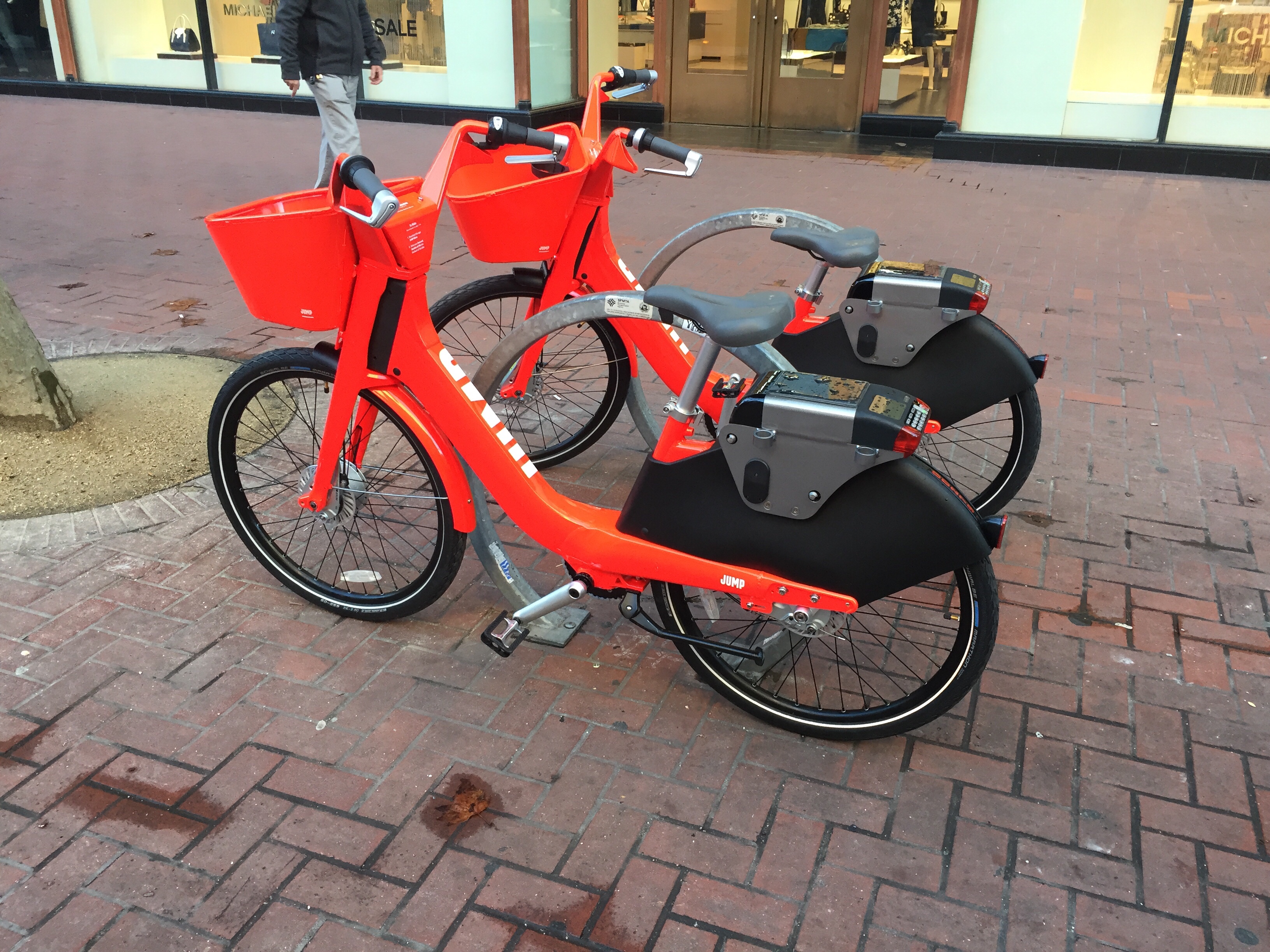
I rode a Jump e-bike in San Francisco yesterday. This was the first day that the program was open to the public, though there had been a low-income pilot going on for several months previously. The bright red (vermillion) bikes are pedal-assist. If you don’t pedal, they don’t go anywhere. But if you do, they really jump out. Though I haven’t ridden any really steep SF hills yet, the bike handled moderate hills with ease. I did ride most of the way across SF and back, and a chose a somewhat more hilly route than I normally would have.

Jump is operated by the company formerly known as Social Bicycles, so the GPS units and locking bar will be familiar to anyone that has used the Tower Bridge Preview bikes in Sacramento. The brakes are different, much stronger, as they should be for a bike that will go 25 mph. There are “gears,” but theses feel different with the pedal assist. The Jump system in SF is truly dockless, unlike the existing Sacramento system which is dock optional. There are no hubs or stations, the bikes can be locked at any bike rack within the system area. On the first day, the bikes were in clusters, with large areas uncovered, but they may become more dispersed over time. The coverage includes two of the lower income neighborhoods in SF, Bayview and Mission, so the user profile may be different than in Sacramento and for the existing Ford GoBike dock system in SF. There is a good article about Jump on SFgate: Jump rolls out San Francisco’s first stationless e-bike system.

The bikes must be recharged every few days, depending on use, and there are no charging stations at least so far, so rebalancing will probably be done as part of recharging. The company reported to me that they are considering hubs, but haven’t located any yet, pending data about use patterns. There seems to be a charging port on the right side of the bike below the handlebars, but it doesn’t look to me as though it was designed for docking/charging stations.

So, back to Sacramento. SACOG and partners have announced that the expanded system in the Sacramento region will use Jump e-bikes rather than the pedal bikes in the Tower Bridge pilot. It is not clear in the announcement whether the Sacramento system will be dockless or dock-optional. I think I prefer dock optional as more of the bikes will be in known locations, but with active rebalancing and recharging, dockless probably works.

The additional hubs (racks with geofences) that we were promised back in September are still not online yet, though most or all of the locations are installed. The most prominent lack is that there is still no hub at Sacramento Valley Station, even though that is the most common non-hub location where bikes get parked. With a May 15 promised opening of the different Jump system, I’m wondering if these other hubs will ever be online.

The 50 additional bikes arrived, though. They have black fenders and baskets. Unfortunately, the practical effect of the additional bikes has not been large. Before the new bikes, the Sacramento side had 20-25 bikes, and it now has 25-30 bikes, though it should have about 50. The bikes are often out of service, mostly due to gearing problems. If you have ridden the bikes, you’ve noticed that the gears slip on many of them. Sometimes this is just irritating, but sometimes it makes the bike unridable. Though this might be a maintenance issue, I suspect it is a design flaw.


The email I got when I joined Jump SF is below:

Hi Dan,

Thanks for joining JUMP SF!

Your account is now active!

Your account number is XXXXXX. Please store this number in a safe place as you will use it to access our e-bikes.

IMPORTANT SAFETY INFORMATION

JUMP is bike share–electrified. When riding the e-bike, start slowly to get familiar with its boost. You’ll feel motor assistance as you pedal. The harder you pedal the more boost you’ll feel. Be sure to try out the brakes to get a feel for stopping.

• JUMP brakes are powerful! Brake early – brake gradually.

• Ride slowly down steep hills.

• Use both brakes together at all times.

• Do not bike one-handed! Do not text while biking!

• Braking hard while riding one-handed is dangerous.

• If you are a heavier rider, ride cautiously down steep or long hills and keep your speed low. Weight limit: 210lbs.

STARTING YOUR RIDE

When you’re ready to take your first ride, enter your account number and PIN using the keypad on the back of the bike. Remove the gray U-bar and place it in the holster loops on the back left of the bike. Adjust the seat height and test your brakes.

PAYING FOR YOUR RIDE

JUMP bike rides cost $2 for the first 30 minutes and just $0.07/minute after that (plus applicable taxes). Your ride begins when you book a bike and ends when you lock a bike.

ENDING YOUR RIDE

At the end of your ride, lock the bike to a public bicycle rack within the designated system area. Bikes should always be visible from the street, and never parked on private property, in parking garages, or in parks. Improper bike locking fees may apply. If you’re ever unsure, check the system area map. Locking the bike outside of the SF system area will result in a $25 fee.

OUR BOOST

On a full charge our bikes can travel around 30 miles with pedal assist. While we do have teams regularly servicing our fleet, please understand that the bike you rent might not be at full charge. If you are riding a bike and the pedal assist runs out, please press the repair button on the bike’s keypad when ending your rental, and lock the bike to a bicycle rack. We will take care of it from there.

Please do not travel outside of the system area unless you are comfortable pedaling without the electric assist should the battery run out. Fees for retrieval of bikes due to low battery outside the system area may still apply.

RESERVING YOUR RIDE

You can walk up to a bike and check it out, or reserve one through the app. The clock starts ticking once the reservation is made. Bikes reserved in advance can be held for up to 10 minutes. Reservations will be canceled automatically if the bike is not unlocked within that time.

HOLD FEATURE

Need to make a short stop on your trip? The HOLD function guarantees that the e-bike is yours for up to 60 minutes. Press the “HOLD” button and lock the bike to a rack. Please note that reservation and hold time count toward your total minutes of riding time.

LINK CLIPPER CARD

You can link your Clipper card after unlocking the bike for the first time. Once unlocked, click Menu > Link Card > Start. Now hold the card directly up against the keypad buttons and wait for the screen to say “Success.” Next time you want to rent the bike, hold the card to the keypad to reserve.

For riding tips and safety information, please see our FAQ. We encourage all JUMP members to wear a helmet while riding. Don’t have one? Visit one of San Francisco’s many bike shops to pick one up, and if you’re a San Francisco Bicycle Coalition member, you can get 10-15% off!

You can learn more about our system and policies by reading our Rental Policy

Thank you again for joining. We think you will enjoy JUMP!

The JUMP SF Team

support@jumpbikes.com