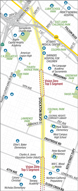
The City of Sacramento is undertaking a Stockton Blvd Corridor Study, covering the section between Alhambra Blvd and 47th Ave / Elder Creek Rd, but focused on the two high injury segments around Broadway to 14th Ave and north of Lemon Hill Ave to south of 47th Ave / Elder Creek Rd. Map below.
Tomorrow, Thursday June 25, there will be a virtual open house at 6:00 pm. There is also a survey which is open through Tuesday, June 30. The survey offers existing conditions information for each of several segments, and then presents two options are asks the user to select one of the other, and make comments if they wish. The options were developed as a result of a community engagement process which was partially led by Jackie Cole of VG Consulting. I attended one of the meetings in February, which had more actual community members than most such meetings, but was only moderately attended. I did not attend any of the other events.
I would encourage anyone who travels on Stockton Blvd, and particularly people who live on or do business on the corridor to take the survey and attend the virtual open house. Please use the comment boxes to tell stories of your personal experiences and concerns using the corridor, as they make a huge difference in the design ultimately selected (we hope).
The nature and width of Stockton (both the street and the right of way) varies considerably over the length of the section, so there is not a single roadway design that can be used throughout.
The survey and background documents do not address the number of driveways along several sections of the road. In some places there are more driveways than not driveways, with each commercial property having one or more driveways. The density of driveways mean that most measures taken to make the street safer for walkers and bicyclists, and faster for transit, will fail. The city must reduce the number of driveways, whereever consolidation is possible. A key question which the survey never asks is what should be the priority of the different travel modes along the corridor. I would argue for:
transit
walking
bicycling …..
private motor vehicles
But your priorities may be different. The reason I place transit at the top is that SacRT Route 51, when highest ridership route in the entire system, runs on Stockton from Broadway to 47th Ave and beyond. This is the sort of ridership that would justify bus rapid transit (BRT) in most cities, and some of the options do ease bus travel but fall short of BRT. And of course people must either walk or bicycle to the bus, and so these two modes must come next. High quality sidewalks and bike facilities can ease these ‘first mile’ trips, and make it possible to reduce somewhat the frequency of bus stops, further speeding the bus.
JUMP unceremoniously pulled out of Sacramento (the Sacramento region program that included West Sacramento and Davis) in the very early days of the pandemic. The bike and scooters disappeared, except for those few that are still out there, abandoned and never picked up. Though the company claimed that the devices weren’t being used, that is not true. Despite people not commuting to work (the stay at home was not yet clearly defined), they were still getting used, at perhaps half the rate as before. I’ve suspected that Uber/JUMP was already planning a pull-out, and saw the pandemic as a convenient excuse. Sacramento had been the most successful JUMP system in the US, in terms of rides per bike per day. Some argue that means they would not have pulled out unless they had to. But I see exactly the opposite reason, that they pulled the bikes and scooters because they were so successfully competing with what Uber considers (and has now demonstrated) to be its core business, ride hailing.
Lime also had scooters here for a while, but they disappeared as well. Spin had a program based on the campus of Sacramento State, and I saw a few of the scooters off campus, but they were never widespread. I’ve heard rumors of other scooter companies, but never saw any of the scooters. There were also some short-lived or planned but not implemented bike and scooter share programs in other cities around the region.
JUMP is now out of the bike and scooter business altogether. They sold the business, and apparently some of the bikes, to Lime. There are stories on the Internet from locations all around the US about Uber recycling the batteries and scrapping the bikes, so this is apparently widespread, and either already has or will shortly erase most of the bike fleet from existence.
Lime had an electric bike share bike for a while, though never in Sacramento. I saw them but never rode one, as the places they were available had alternative vendors that I was already using. The reviews I read said they were much better than the pedal bikes Lime was famous/infamous for, but nowhere near as good as JUMP bikes.
So, what does this have to do with re-opening from the pandemic? I have not heard anything from any of the agencies involved in the bike share program about how bike share can be brought back. SACOG (Sacramento Area Council of Governments), the original sponsor of the Tower Bridge pilot program (remember the white SoBi bikes?), SMAQMD (Sacramento Metropolitan Air Quality Management District), which provided some of the start-up funds, the City of Sacramento, the City of West Sacramento, and the City of Davis. Not a peep. There may be discussions going on, just not public, or there may not be.
This region, not just the area covered by the JUMP program, must have a bike share program. I am less certain that scooters must be part of the program, but I’m sure many feel they should. As people who were using transit but are not willing to right now, for an unknown but hopefully not too long period of time, search for alternatives, the choice to drive, and often to purchase a vehicle in order to drive, would be disastrous for the region. Our air quality has been wonderful for three months, but has already returned to the ‘unhealthy for sensitive individuals’ level even with only a fraction of the pre-pandemic traffic levels. If 80% of those who were using transit now drive, air quality will likely be in the ‘unhealthy’ for all category for much of the summer, and jump into the ‘very unhealthy’ category from time to time. We can’t let this happen. We must provide alternatives for people who cannot and will not drive, and that must include bike share. Of course the impact of motor vehicles, more than 40% of carbon emissions in the state, go far beyond current air quality to civilization-changing climate change, but my biggest concern right now is the short term impact on air quality.
Beyond air quality and climate, there are equity concerns about how we re-open. Yes, I know the JUMP system was not perfect. Even after expansion, it covered only part of the low income communities in Sacramento. JUMP had a low income uer discount program, but it was almost a state secret, and they never solved the issue for unbanked people.
We know that most transit users right now are essential workers and people who have no other way of getting to essential destinations. Those who can have been driving, but many can’t. They are not of a driving age (too old or too young), the have valid reasons they are unable to drive, and they simply do not want to be a part of the planet-destroying car obsession. What are we doing to do for these people? Are we going to put all our transportation eggs (funding and projects) into the cars-first basket, as we have done for too long, or are we going to change our futile ways and provide real alternatives? Are we going to commit low income people to a descending spiral of debt as they try to keep old cars running, or buy cars that barely run, just so they can get where they need to go?
The solution is bike share. Here is what I think needs to happen:
Equity concerns must be predominant in rolling out the new bike share system. Who really needs this option? How can we make sure it works for them? As one of my favorite people, Tamika Butler (and many others) has said, we don’t want to return to normal, because normal was never acceptable. High income state office workers are not the people the new system should be designed for, though certainly it should work for them too.
We must discard the idea that a privately owned and operated system can work to meet the transportation needs of the region. It could be a public system, or it could be a public/private system, but it cannot ever again be solely private.
Bike share is identified as a critical transportation service, and as a logical part of the transit system. This does not mean that it is operated by transit agencies, though it could be, but that transit agencies are a core partner in the program.
Major traffic attractors will not reopen until a bike share system is in place to handle the additional car traffic that might otherwise be generated. This most definitely includes shopping malls, and probably includes government offices in downtown Sacramento. Universities and colleges are not an issue, for now, as they will be online and not the trip generators they usually are.
Funding for bike share infrastructure (bikes and bike racks) will be diverted from road building projects. If the emergency powers of the state and county have any meaning at all, this is well within their power to do. When transportation agencies talk about the ‘color of money’, what they generally mean is that they don’t want to make the effort to justify different uses, and they are happy with the current mode share. Time to end that malfeasance.
Sacramento has implemented changes to the streets along 18th Street and along Capitol Avenue and L Street near the intersection of the three. There may be other locations in Sacramento, but I’m not aware of them.
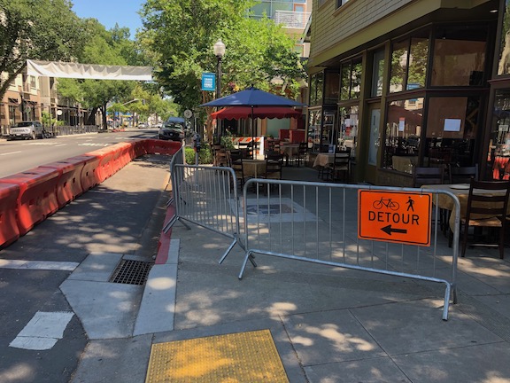
L St at 18th St restaurant space
The first example, along L Street at 18th Street, is for Aïoli | Bodega Española. The sidewalk has been closed and an alternate sidewalk provided in what was the parking lane on the south side of the street. There are a few widely spaced tables.
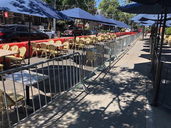
18th St at Capitol Ave, restaurant space
The second example, along 18th Street just north of Capitol Avenue, is for Zocalo Restaurant. It could also be used for the adjacent business, but doesn’t seem to be. The sidewalk was retained (more or less, there is a slight narrowing), and the angled parking on the east side of the street was converted into seating area.
The ADA ramps which go around the sidewalk closures look sketchy to me, but I don’t have expertise in that aspect of ADA, so I’ll leave that to others who do.
I think this is a great use of street space to help restaurants meet the challenge of physical spacing while reopening. I prefer the situation where the outdoor seating in in the parking space, rather than the sidewalk being diverted to the parking space, but each situation is unique, and it should work for the business and the walking public.
Of course with any of the ‘temporary’ COVID-19 measures, the question is, should this be a permanent solution? I think this needs to be a negotiation between the city, the business owners, and the public, but I do think in many cases, the answer is yes.
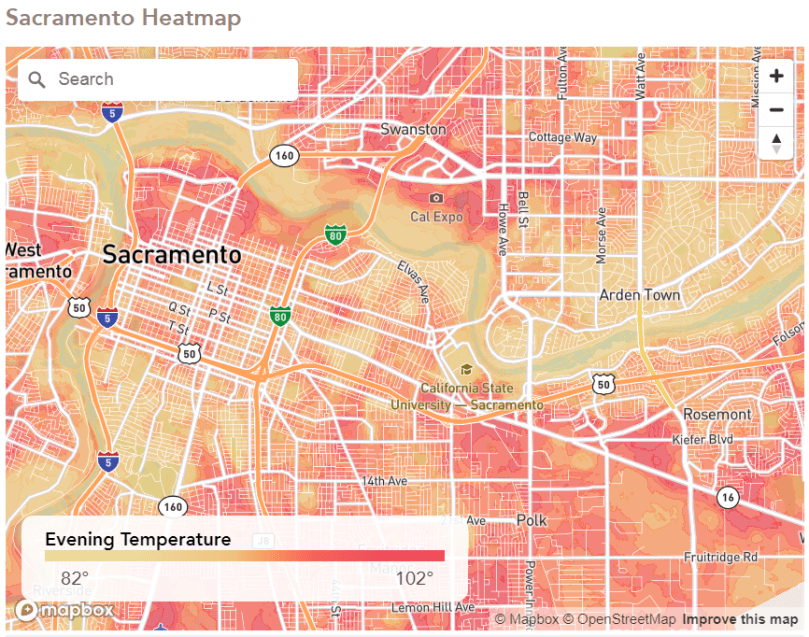
The lower temperatures along the river corridor are of course expected. And so is the pattern, almost universally seen here, that lower income locations have higher temperatures. One could speculate that these areas never had as many trees, but I don’t think that is the explanation. It has to do with sidewalks, and city neglect.
I walk a lot, and to the degree possible, walk throughout the city. What I see in the lower income neighborhoods is a decline in trees. Many have been removed, and many of the ones remaining are declining in health. I do not think it is because people who live there don’t care about trees, quite the opposite. It is because there are more renters in lower income neighborhoods, with landlords who do not care much about trees, or other things. For those who do own their homes, it is a struggle to pay the bills and take care of trees.
When these neighborhoods were built, they probably had just as many trees as any of the leafy neighborhoods in midtown or east Sacramento or Arden Park. But these neighborhoods are old enough that many of the trees are dying out (maybe for lack of care, more probably because they were not the right tree for the context), and not being replaced. The homeowners or renters don’t have the money to replace them, and the landlords don’t care.
So why are there still trees other places? Because the design of streets in many higher income neighborhoods feature detached sidewalks, with a buffer in between the street and the sidewalk. This is the standard design for livability in all but intensive retail areas, and adds significant safety and comfort for walkers. But in the second ring and beyond suburbs, most streets are either without sidewalks or have attached sidewalks, with no buffers. So the trees were in people’s yards, not in the buffer. When they die or are taken out, the city has no responsibility. When there are buffers, the city replaces the trees. Yes, they are incredible slow about doing so, but it does eventually happen. And it happens for the most obvious of reasons, that richer (white) people get what they ask for in this city.
The city also repairs sidewalks when the buffer tree roots systems begin to crack and heave the sidewalk (many buffers were too small for the trees planted in them). Not with alacrity, but they do it. When a yard tree cracks and heaves a sidewalk, the city sends the owner a notice to repair.
tree in sidewalk buffer, with city repaira typical lower income neighborhood, no buffer, no city maintenanceno buffer, rolled curb, no yard trees (though there were at one time)
A person posted in reply to the CapRadio article that the Sacramento Metropolitan Air Quality Management District did a Urban Heat Island Project to assess the issue and solutions. Good for the air district, and good for the study, but what about action? What about the city? What is the city doing, proactively, to get trees back into low income neighborhoods?
Tree redling also relates to the issue of sidewalk responsibility. Sidewalks are a part of the city’s transportation system, and are legally and morally the responsibility of the city to maintain. The idea that we provide for cars and car drivers, while leaving walkers to the vagaries of private property owners is an idea whose time has passed. In fact, I think that the city should establish a program of repairing and installing sidewalks before ANY road repairs are done. It will take many years to undo the damage of our cars-first transportation system and funding, but the time to start is now. Where sufficient public right of way exists, and sidewalks are in need of significant repair, existing sidewalks should be replaced by detached sidewalks, with buffers and street trees.
The City of Sacramento is not taking the failures of its construction zone signing and maintenance seriously. I have forwarded a number of issues to the city, both via email and via the 311 service. Nothing seems to have come of any of this. I have not seen a single location corrected. The 311 requests are being closed without being corrected. It is not clear to me whether the city staff are incompetent, or simply don’t care, but I’m going to list some resources I’ve found useful. These may be useful to readers, so that you can recognize failures and report them as well.
The Manual of Uniform Traffic Control Devices (MUTCD) addresses construction zones in Part 6: Temporary Traffic Control Devices. California has its own version, similar but not identical, the CA-MUTCD Part 6. Don’t misunderstand me, the MUTCD/CA-MUTCD is very weak on pedestrian and bicyclist accommodation. If you randomly threw a dart at the manual, 999 times out of 1000, you would see text or signs or diagrams that assume that pedestrians and bicyclists don’t exist. Nevertheless, the manual has the force of law, for any agency that uses federal funding, and it is what most agencies use as the gospel.
pedestrian barricade, with detectable edge (National Work Zone Safety Info Clearinghouse)
Note that the MUTCD prohibits the use of tape, rope, or plastic chain strung between devices because they are not detectable and do not comply with the design standards in the ADAAG; therefore, they may not be used as a control for pedestrian movements (MUTCD 6D.01).
National Work Zone Safety Information Clearinghouse
The safety justification doesn’t hold water. The interchange itself has no fatal collisions and no severe injuries during the period of time analyzed (safety starts at about 9:56 in the video). The severe injury collisions are all outside the project area. The city is definitely trying to gaslight people on the safety issue. If the city were actually concerned about safety, they would be doing projects at the severe injury locations. But they are not. In fact, unnecessary projects like this one gobble up the funds that could be used to solve real safety issues. It is worth pointing out that this area is not a high priority in the city’s Vision Zero program. There are many, many areas in the city with far higher collision rates.
The information on bicycle and pedestrian improvements is very fuzzy. Nothing is indicated that to me makes is seem safer for either. More traffic means less safety, unless the safety improvements are substantial, and I just do not see that here. See DDI comment below.
The project points out rightly there there will be increased demand for travel as a result of residential, commercial, and public development in the Railyards and River District areas. But it makes no mention of other ways of solving the issue. Demand management? Never heard of it. The project simply accepts that traffic congestion will get worse if no infrastructure is built, so infrastructure must be built. Of course the EIR has to consider the no-build alternative to be legal, but the city is certainly not presenting that option to the public.
The project uses traffic delay through the interchange (on the interstate) to justify the project. The current traffic delay is due to the fact that commuter traffic has been encouraged by the provision of additional capacity on Interstate 5 to the south of the city, and on Interstate 80 east and west of the city. Of course things will get worse at this location, as more people commute and travel on this increased capacity. This is called induced travel, and is to be expected. Induced travel is increased by capacity expansion projects.
The city wants to spend $46 to $100 million of your tax money to ‘solve’ this problem. If we let them do that, they will be back in a few years with another project to ‘solve’ the problem at some other nearby pinch point, and the new project will be even more expensive because they have induced more travel by ‘solving’ the perceived congestion problem here.
It is time for us to demand that highways engineers be cut off from building new capacity. They see the taxpayer pockets as their piggy bank. Fix what we have, and invest the remaining transportation funds in supporting walking, bicycling, and transit.
The projects proposes making the interchange into a diverging diamond interchange (DDI), where the travel lanes switch sides under the freeway so as to reduce the number of intersections, and to ease common vehicle movements. Some people hate DDIs. Traffic and highway engineers love them. I’m pretty indifferent. I have spent a lot of time observing DDIs, before and after. They do offer some improvement in traffic flow, and they do offer minor improvement in safety for drivers. They are not any better or worse for bicyclist and pedestrian comfort and safety, IF they are designed properly (I’ve seen some very poor installations, some of which won awards from AASHTO, the highway lobby entity, that never saw an expensive project it did not love). It does take a period of a year or two for people to adjust to the different feeling of a DDI, but that is not necessarily bad. So my opposition to this project is not due to the DDI, but other issues. Others may feel differently.
The City of Sacramento recently release a new 311 app. I have been using this app (iOS version), mostly to report issues with construction signing. The app is broken!
What are the issues?
If you switch away from the app to some other app, the app logs you out, and you have to log in again.
Once you’ve logged in again, it asks you to confirm your contact details. Even though it asked you to do that moments ago – it doesn’t keep track.
It will not allow you to upload photos. Usually it give an error message, photo could not be uploaded, but sometimes it hangs the entire app. If you are wondering, it makes no difference whether you take the photo then or try to use an existing photo, nor what size you attempt to upload.
The app (and the website) is happy to show you requests you’ve made, but the only information on the request is the cross streets or address that you reported. It doesn’t show what the request was, so if you’ve made more than one request on the same location, or simply don’t remember what the request was, you won’t get any help from the app (or the website).
An ongoing problem, not specific to the app, is that the city closes requests without saying whether they did anything or not. The only way for you to know whether they did anything is to go back to the same location, and look to see. That’s if you remember what your request was.
Thanks for the website Mapping Inequality: Redlining in New Deal America, I have better copies of the Sacramento redlining map, which was produced in 1937 by the Federal Home Loan Bank Board and the Home Owners Loan Corporation (HOLC). These were government sanctioned zonings meant to guide banks to only loan to certain kinds of people in certain areas. Specifically, higher income white people.Though the official endorsement of the federal government eventually ended, the practice continued into the 1970s, and is with us still today. The best book on it is The Color of Law: A Forgotten History of How Our Government Segregated America by Richard Rothstein, which I highly recommend.
I had seen this map before, most likely from the posts of Bill Burg, but had not seen a high quality version, and had never found the GIS data. In 1937, Sacramento was a pretty small city, not going south past Land Park or north past Del Paso Heights, so the maps only cover a tiny part of what is today Sacramento. But as the city grew into other areas, the same practice redlining continued.
The first map below is the ArcGIS version, the second a scan of the original 1937 map.
Sacramento HOLC redlining map 1937 (click for pdf)original map, scanned (click for high resolution)
The 2017 video, Why We Cycle, was offered for free streaming for one day, yesterday. Though the freebie is over, I highly recommend you watch the video; at $4.99 it is still a great deal. This video has brought joy to me in ways that I haven’t felt in a while, and I think it will do the same for you.
So if you can push the car out of the city grid, leave it at the edges, and go walking further, it’s an enormous advantage for health, for clear air, for interaction.
Sjoerd Soeters
Though the bicycling infrastructure in the Netherlands has received the greatest notice in the US, this video is only secondarily about the infrastructure, instead focusing on cultural capital and transformation.
My own commute is cycling, that’s because I live cycling distance from work, but that is not a coincidence, that is why I live there.
Erik Verhoef
The video demonstrates the long list of benefits to a cycling culture (note that the video unapologetically uses the term cycling, without the cultural baggage of spandex and Strava and high priced bikes that the term carries in the US):
convenience: the bike is often the quickest way to get somewhere
economics: the bike is far less expensive than private motor vehicles, and even than transit
health: an active life brings measurable and significant benefits to the individual and to society in health care costs
cognitive: because bicycling requires people to be aware and interact with a large amount of information, there are clear benefits to cognitive development and maintenance
creativity: bicycling increase creativity, while on the bike and in life
reduced absenteeism: work absenteeism is lower for people who bicycle, and presumably for school as well
freedom to move: people are much freer to go where they want to go, when they want to go, on a bike
diversity: bicycling exposes people to diversity that they would not be if driving, to meet the ‘other’, to actively negotiate the flow with others
It’s the story of living in a city that is human scaled, that allows me to engage with the social/spatial environment… the intangible effects…
Marco te Brommelstroet
Data on bicycling trips clearly pointed to the conclusion that choices were often governed much more by the senses than the coldly logical plans of traffic designers, even causing people to leave the safe but sometimes boring cycle-ways for more interesting routes.
I noticed in the video, and it was commented on by one interviewee, that some signals have all ways for bicyclists at the same time, a bicycle scramble, so to speak. Because bicyclists have so much experience with negotiating with each other, it just works!
… it relates to the culture of mutual shared respect, but also the culture of trust; instead of infrastructure, by the users of infrastructure
Fariya Sharmeen
The adolescent social area can be the whole city, not a limited area close to the home. It’s about fun, being together. The video highlighted schools where nearly every student walks or bicycles, such a huge contrast to the US.
Dutch children are the happiest children in the world, just because they can go farther and farther from their homes…
Cycling is a good metaphor for a good education.
… to put the priority in relationships between people, then we support the cycling, we support freedom for children. Priorities for children and for bikes are good priorities for a happy politics.
Leo Bormans
A better world is possible, and we can achieve it if we work together and insist that each decision we makes moves us towards that end, and away from the car supremacy under which we have suffered, and died.
The last month has brought an awareness to many people about what essential is. I doubt if you asked people in January who the essential workers are, you would have gotten an answer that matched who turned out to be essential. I probably would have missed most of them. It is not the rich, or the techies, or the entertainers, or the politicians. It is the lower paid workers, the people who pick, harvest and prepare food, the people who staff grocery stores and pharmacies, teachers, and of course the medical profession. I am not in any of those categories, and the fact that I am not, and am still working and getting paid, means our society has been valuing the wrong people for the wrong reasons.
With our new understanding of essential, I am wondering how we apply this to driving. What is essential driving? Streetlight VMT Monitor indicates that driving in Sacramento County is down 66% (2020-04-14). What were those trips that were formerly being made? Well, some of them were commuting to work trips, but those would account for no more than 2 one-way trips per day, for some people. Nationally, commute trips are down below 25% of total trips. So that can’t explain a 66% decline, even if no one were going to work, which we know is not true. I suspect people who are doing what could be considered essential trips – to essential jobs, and to the grocery store and medical services – are about the same rate as before, so that doesn’t account for the decline either. The only conclusion I can come to is that a significant portion of those trips not now being made were non-essential.
I know that when I am out walking and bicycling for physical activity, I see a lot of people who are probably just driving for pleasure. Obviously those speeding egregiously, which is at least 20%, are driving for the pleasure of doing what they want on the mostly empty roads, other people be damned. And a lot of the other people do not seem to be heading towards or away from work, or the grocery store. A lot of people are just out driving around. If we eliminated these non-essential trips, I suspect VMT would be down at least 80%.
Even the grocery store is problematic. I see people coming out of grocery stores with a small purchase, an amount that could easily be carried on a bike, or even walking. Of course I don’t know how far these people are going, and what their specific situation is. It true that many, many people have chosen to live in places where the distance to a grocery store is not walkable or bikeable, the sprawling suburbs. Conversely, some people don’t have much choice about where they live, and end up in food deserts, because they can’t afford to live in places with grocery stores. And there are a few people whose only reasonable transportation mode is a car, due to physical disability, but those are very few in number. I am going to say that many trips to the grocery store also fall into the non-essential driving category. (Note: this was going on long before the pandemic, with Trader Joe’s being the poster child for people who drive to the store and leave with small amounts of groceries not requiring a multi-ton motorized vehicle to transport.)
Let me say up front that I have no data to back up what I’m going to say. But it does fit the data about VMT reduction, and what we know about travel modes, and what I observe on the street.
At least half the car trips formerly being made were non-essential. Probably much more.
So what? Well, we know, unless we are ideologically opposed to knowing, that motor vehicle travel is 40% of all carbon emissions in California, and it is the portion of our emissions that we have made no progress in reducing. So, every non-essential car trip is a crime against the climate, a crime against people’s health, a crime against livability of cities.
I am not sure how to best eliminate all these non-essential trips. Pricing fuel, or travel, or parking, is part of the solution. This is often called congestion pricing, but the point is not to reduce congestion but to eliminate unnecessary travel. We need to stop subsidizing non-essential travel, we need to make it hard for people to make this choice. Obviously the controls cannot be primarily economic, as that would hurt the people the most, who have the least choice. But it must be in part economic, because middle and upper income people make choices based on money.
Some suggestions:
Convert areas of the city that are and look urban (downtown, primarily, but other areas as well) into superblock areas, a la Barcelona, where many of the streets become car-free or car-light. This is easiest to do where there is a grid street network, harder but not impossible to do other places.
Reduce street parking significantly, starting with streets where the right-of-way is needed for other purposes, such as sidewalks, sidewalk buffers, and bicycle facilities. I am not against street parking, as it does serve somewhat to slow traffic, but where the space has a higher use, it should be eliminated and reallocated. At the same time, we should never build another structured parking deck (parking garage). These structures NEVER pay for themselves in parking revenue, and so they are a subsidy from everyone to drivers (whether they are public or private, makes no difference, they are an inefficient use of capital). I would suggest we eliminate 10% of all parking in the central city, within one year, and then evaluate the impact on non-essential travel. If it has not decreased significantly, then eliminate another 10%, and on until non-essential travel becomes rare.
Charge the real cost of parking, on street and decks. The city only charges enough, roughly, to cover the cost of the program, meaning enforcement and administration. The land used by parking comes free, as a subsidy to those parking. The cost of repaving the parking lane (which we should not be doing anyway) comes free, another subsidy. The difficulty the city has in converting parking space to other uses, such as bike corrals, parklets, delivery zones, and drop-off/pick-up areas, which are often higher uses than parking, is another give-away to drivers, and residents and businesses who think they own the parking spaces.
Shift transportation expenditures away from private vehicle transportation, in favor of necessary freight, transit, walking and bicycling. That means #NoNewRoads and #NoNewLaneMiles. We maintain what we have but we don’t build any more. We stop paving parking lanes to the same standards as streets, and let them deteriorate. And we let low-traffic streets that serve very few people (cul-de-sacs, primarily, though some semi-rural roads, as well) go back to a natural surface, unless the users of that street want to pay the full, unsubsidized, cost of paving.
There are a lot of reforms that must happen at the state and federal level, and I’m not addressing those here. These are ideas that can be implemented locally, at the city and county level.