9th St fixed, sort of

Following on to the post 9th St blocked by construction, the city has partially fixed the issue.

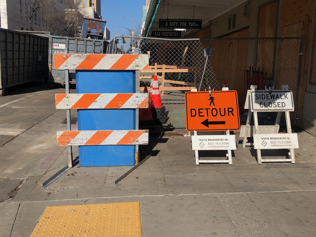
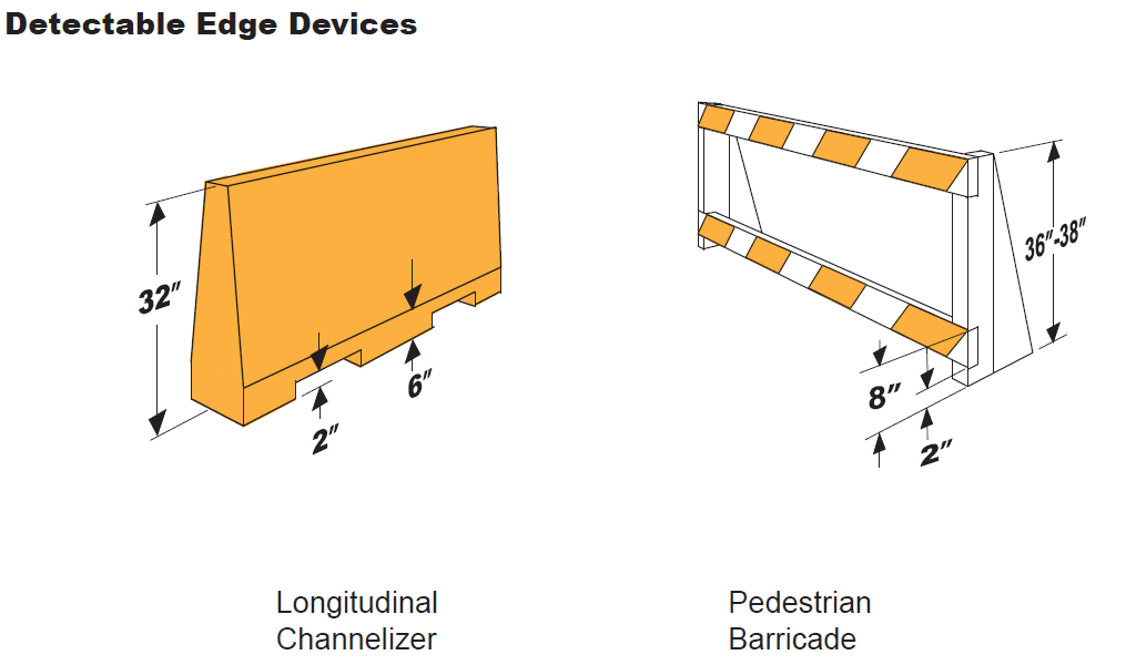
At the south edge of the sidewalk and bikeway closure, at L Street, there is now some signing, below. However, the signing and fencing do not meet ADA detectability requirements. Though there is more than one way of meeting detectability, an example graphic follows, showing a low bar across the entire width, detectable by canes used by vision impaired people. See my earlier post signs and diagrams for construction zones and construction zone solutions for more information on signing and barriers.

9th St at L St sidewalk closure signing

What would otherwise be a reasonable route and signing for northbound pedestrians is blocked by an open construction gate. This open gate was not being actively used in any way, it had just been left open. A person walking is forced to walk outside the crosswalk to get to the bypass.

9th St at L St bypass entrance and signing, blocked by construction gate

For southbound bicyclists on 9th Street at K Street, the diversion starts suddenly, pushing bicyclists into the traffic lane without warning. This is not necessary, the construction cone placed blocking the separated bikeway should not be there. This is just plain sloppiness. The bikeway could remain open, with a half block available to place signing that explains there will be a diversion and bypass ahead.

9th St blocked separated bikeway

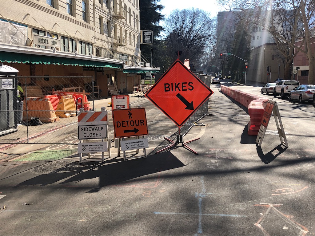
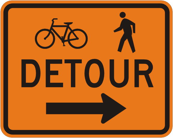
Then there is the entrance to the walking and bicycling bypass, below. The same lack of detectable barriers as in the first item also exists here. If a vision limited walker encountered the construction fencing across the sidewalk, they would have no idea where the bypass is. The ‘sidewalk closed’ and ‘pedestrian detour’ signs are MUTCD compliant signs, MUTCD R9-9 and MUTCD M9-4b respectively, but they need to be placed on or above a detectable barrier, not on sawhorses which do not meet detectability requirements. The ‘bikes’ sign is a made-up sign, and because of its size, it intrudes into the shared bike and pedestrian space. I can imagine bicyclists hitting the sign on their way into the bypass. The correct sign for the location is actually MUTCD M9-4a, shown below.

9th St pedestrian and bicyclist bypass
MUTCD M4-9a right

It took about four weeks for the city and construction company to come up with and implement a new traffic control plan, which is ridiculous. If there had been a problem with motor vehicle traffic instead of for walkers and bicyclists, it would have been solved in less than a week. And it would have been done right. Either the new traffic control plan does not really meet ADA requirements, or the signing and barricades placed do not follow the traffic control plan. Remember, this is a city project, reconstruction of Capitol Park Hotel, so not only is the city responsible for managing streets, but also for managing the construction project. Take a look at the photos, or go walk or bicycle the section of 9th Street between K Street and L Street. The sloppiness of the work is glaring. As I’ve said before, the city does not care about walkers and bicyclists, and is not fulfilling its legal responsibilities.

Why is that I, a private citizen, continually have to tell the city when they are doing things wrong, and how to do it right?

pandemic of red light running

There is a pandemic of red light running in Sacramento, and probably everywhere else. There have always been some red light runners. But since the pandemic emptied many streets of prudent drivers and left them wide open to egregious violators, the problem is much worse now. I am not talking about drivers who ignore or speed up on yellow, and are still in the intersection when the light turns red, I am talking about drivers who enter the intersection when the signal is already red. Often, they speed up approaching the intersection, guaranteeing that any crash will be more serious.

I know many people will not believe this, or will offer up one of many windshield perspectives on why this is not really a problem: bicyclists run red lights all the time and pedestrians jump into the street, so that crashes are their fault and not the fault of the driver. Bullshit. This is an intentional behavior by people who know that they are driving in a dangerous manner, but think they’ll get away with it. And they often do, since other drivers and walkers and bicyclists mostly know not to enter an intersection without looking to see if any of these criminals are coming.

So, if you are a doubter, I ask that you spend time observing a busy or moderately busy intersection. It probably won’t take more than 10 minutes before you see someone run a red light. This behavior truly is pandemic.

One of my observations is that about 2/3 of these are drivers of high value cars, BMWs and huge pickup trucks being the worst offenders. These people, in the unlikely event that they get a ticket for their violation, probably just see this as a minor expense for driving the way they want to. If you don’t believe that the drivers of different kinds of vehicles behave differently, please see Driving Drunk: Car Models with the Most DUIs.

A walker who steps off the curb when the pedestrian signal gives them the right of way are significantly more likely to be hit, or narrowly avoiding being hit, by these criminal red light runners. Same for a bicyclists or other drivers who enter the intersection when the light tells them it is their turn. The situation is slightly different for walkers, who do have the right of way, and bicyclists and drivers, who can enter the intersection when it is safe to do so. But in all cases, the violator is endangering the lives of others.

Red light running is a behavior that is certain to result, sooner or later, in serious injury or fatality. As such, it should be a high priority for enforcement. Both red light cameras and on-the-ground enforcement are needed, and must continue until this criminal behavior recedes at least to pre-pandemic levels, and then beyond that, until it is eliminated.

Some specifics:

  • red light running tickets should be based on the value of the vehicle, so that high income people with high value cars are penalized at a level that will actually change their behavior, and conversely that low income people are not penalized in a way that leads to a downward spiral
  • all red light tickets, whether camera or on-the-ground, must require an appearance before a judge; short-term suspension of the drivers license should be the default punishment meted out; repeated violations should result in permanent revocation of the drivers license and confiscation of the vehicle
  • law enforcement should prioritize observation of and enforcement of driver behaviors that are most likely to result in serious injury or fatality; these behaviors in my mind include egregious speeding (more than 20% over speed limit), failure to yield to pedestrians in the crosswalk, and of course red light running; CHP really only cars about speeding, but this must change. Other law enforcement agencies are more likely to pay attention to other violations, but still not enough.

Some places have red light cameras to catch red light runners, but many places do not. The City of Sacramento has eleven locations with red light cameras, out of about 900 intersections. Sacramento County and the City of Citrus Heights have cameras, but I’ve been unable to find locations or numbers. Rancho Cordova has four locations. The City of Folsom apparently has none.

corner retail

I have been thinking about the value of corner retail for a while, and gradually collecting photographs of corner retail in Sacramento. A Twitter reference also brought me to an article from last year by the Congress for New Urbanism, Public Square “Corner stores can anchor a neighborhood“. What moved me to post now, though, is the recent death of Calvin Yang, owner of the Sacramento midtown market, DJ Market. See Sacramento celebrates life of beloved midtown store owner Calvin Yang with vigil, memories. It really brought home to me how important these neighborhood, locally owned, small businesses can be to the community. They are a key part of livability.

DJ Market, midtown Sacramento, memorial offerings

Using the term corner retail, I’m not just referring to corner markets, but to any public-facing business on a corner. In the Sacramento central city, these include frame shops, child care, laundromats, barbers, coffee shops, bakeries, restaurants, bars, record stores, and many more. Though grocery stores or markets are probably the most important, it is the variety of small businesses that make it work. And I am going to claim that much of the livability of the central city comes from these having these businesses close to hand. It is part of the 15-minute city that I will post on soon. The main point of 15-minute cities is that everything you need on a day-to-day basis is within a walking or bicycling distance of where you live.

One of the things I will never understand is people driving to get coffee, and even worse, drive-through coffee. I’m not a coffee drinker, but I do go out often for tea. My favorite location is The Mill on I Street, not because it is the closest to where I live, but it is walkable and easily bikeable, and I really like the owners. I have said for years, long before coffee places became more commonplace, that the single greatest determinant of livability is the density of coffee shops. It doesn’t matter whether you go out for coffee, or make it at home, or don’t drink coffee at all, having one or more coffee shops in your neighborhood means you are in a livable, walkable place. Coffee places are not just places to get coffee, but what are called third places, where people can socialize and get to know their neighbors.

It is also relevant to me that these corner lots and small, often quite old, buildings cannot host a chain business, except in some cases what I’d call local chains, of which coffee places are probably the most common. A national or regional chain simply cannot compete in this local environment.

I’m not referring here to modern mixed use buildings that contain ground-floor retail, nor am I referring to commercial/retail blocks or clusters where there are a number of businesses. These are businesses on the corner, adjacent to largely residential. Though I certainly support those as well, they are not what I’m calling corner retail.

My apologies for the central city focus in the post and the gallery of photos. I live downtown, so it has been easy to get to these locations for photos. When I have the chance to get to the other important parts of the city, I will post again. I have probably missed a number businesses that should be in this central city gallery.

What is your favorite corner retail? How often do you go there? How important is it to you that these places exist? What other businesses would you like to see within walking distance of your home?

East Sac Hardware closing

I read with sadness in a Sacramento Business Journal article (https://www.bizjournals.com/sacramento/news/2021/01/29/east-sac-hardware-closing-permanently.html; paywalled, but there is a not-paywalled article at https://insidesacramento.com/farewell-neighbor/) that East Sac Hardware on Folsom Blvd is closing soon.

East Sac Hardware

I don’t question the business and property owners right to do what they want with the business and property, but the closure is nevertheless a big loss to the community. Locally owned businesses are almost always better in my opinion than national chains. Local stores and staff know their customers, and their customers often know them. Yes, I will admit that big box stores often have lower prices, but despite their huge floor area almost never have a better selection. I’d rather get exactly what I need from a local hardware store than something that sort-of-might-do from a big store.

The biggest losses here are the staff expertise, quantities, and location:

  • Expertise: In a local hardware store, the staff almost always knows what you need, or don’t need, and how to install it or use it. Home Depot and Lowe’s, not so. Though I rarely go into these big box national chain stores, when I do, I can’t get good help. Every once in a while I do find someone, but it always turns out they are retired from a real hardware store and just picking up some income and wanting to still serve the public.
  • Quantities: Another issue with the big stores is that you can’t buy just what you need. Need a screw or a bolt? They have them in packs of 25 or 50 or 100. In a real hardware store, you can buy just that one screw or bolt.
  • Location: Another big issue with the loss of hardware stores is that a person has to drive further and further to the big box store. Fortunately there are still two real hardware stores that I can access, Capitol Hardware on I Street in midtown Sacramento, and Emigh’s Hardware in Arden-Arcade. Emigh’s has expanded and diversified, so will probably survive, but I am concerned for Capitol.

And when was the last time you saw a mural on a big box store?

I believe that local businesses both create and support livability in a community. Big box stores do not. Though their employees may be local, their owners are not, and decisions are made by a corporate headquarters that knows little, and probably cares less, about the local community. Home Depot is headquartered in Atlanta, Georgia and Lowe’s is headquartered in Mooresville, North Carolina, though you’d be hard pressed to find that information on either of their websites.

Sac one-way to two-way

The City of Sacramento Downtown Mobility Project includes the conversion of two one-way street segments to two-way. Specifically, I Street from 15th St to 21st St, and 5th Street from I St to X St. The time frame for these changes was projected to be 2021.

Note that 5th Street is already two-way from L St to J St, and from I St to Railyards Blvd. One-way 5th Street significantly handicaps access from the south to and from Sacramento Valley Station.

Downtown Mobility Plan

The 2040 Sacramento General Plan mobility element Proposed Roadway Changes map (10MB; this is from the City Council agenda item 15 for January 19, 2021, I’ve not found it on the city website) indicates additional one-way to two-way conversions in the central city. On the clip of the city-wide map showing the central city, below in pinkish, these are small sections of 3rd St, sections of 7th St and 8th St, one block of 16th St, small sections of 19th St and 21st St, sections of G St and H St, some additional sections of I St, a long section of N St, and small sections of L St and P St under the Business 80/Capital City freeway. There is no indication of sequencing of these conversions in documents available so far, but since the plan is a 20 year plan, I would hope that these conversion are prioritized for the next five years.

2040 Sacramento General Plan, Proposed Roadway Changes, excerpt

I’ve written a number of times about the safety hazards of one-way streets and recommendations for converting them in Sacramento: One-way streets, again; 5th Street mess at Sac Valley Station; more on conversion to two-way streets; street changes. When these additional conversions are implemented, the central city will be closer to my ideal of no one-way streets except when there is a separated (protected) bikeway on the street. An even this is questionable, as it increases safety for bicyclists but does little to increase safety for walkers.

Someone recently asked when the streets in the central city were converted to one-way, and I don’t know. Anyone out there have information?

Reform NHTSA? Hmm…

Congratulations to Californian Steven Cliff on his appointment as interim administrator the National Highway Traffic Safety Administration (NHTSA). See StreetsblogCal post Steven Cliff, from California Air Resources Board, Appointed Acting Head of National Highway and Traffic Safety for more information.

The agency has many areas of responsibility including vehicle safety and education. The agency mission is: “The National Highway Traffic Safety Administration is responsible for keeping people safe on America’s roadways.” The agency has for years (long predating Trump) seen its mission as making it safe for people inside vehicles, and has ignored any issues of safety for people outside vehicles. People have repeatedly asked that the agency address vehicle design that would make it safer for people outside, making it less likely that they would be hit by a driver, and more likely to survive if they were hit. Its education programs are rife with victim blaming and bias against walkers and bicyclists. Nearly everyone who is active in the walker and bicyclist safety profession rejects out of hand their educational materials as being so biased as to be unusable. Even though they have officially stopped using the discredited claim that driver behavior is responsible for 94% of crashes, they are still relaying and cheering on this garbage when other agencies and organizations use it.

NHTSA has promoted the ‘shared responsibility’ mythology, that all users of the road are equally responsible for safety, frequently seen along with the message that walkers and bicyclist must wear high visibility clothing, must carry lights, must never use cell phones, must be aware at all times of the hazard presented by motor vehicles and are responsible for avoiding those hazards. This is bullshit. Drivers of vehicles which are designed to be unsafe for people outside them, who think they own the road and that pedestrians and bicyclists should be somewhere else, should be responsible. These drivers are traveling along roadways that were designed to be unsafe for walkers and bicyclists by transportation agency engineers, who also should be responsible.

NHTSA does not have responsibility for roadway design, that lies with the Federal Highway Administration (FHWA). However, NHTSA has made no effort to work with FHWA to bring together concerns about the safety of vehicle design with the safety of roadway design. The agency view seems to be ‘not our problem’.

I encourage you to read Don Kostelec, who has been one of strongest voices highlighting the victim-blaming of agencies like NHTSA and the mis-design of roadways by engineers. He does a better job of this than I ever could.

20% of roadway fatalities in 2019 were what NHTSA calls ‘nonoccupant fatalities’, meaning people walking and bicycling. Or eating in cafes, or sleeping in their beds, or shopping in stores, or any number of other ways in which drivers kill people when departing the roadway. During the pandemic there has been a huge increase in poor (criminal) driver behavior, and after the pandemic there will be a large increase in vehicle miles traveled (VMT). In some places, vehicles miles traveled (VMT) has already increased nearly back to where it was before the pandemic, even though many people are taking few or no trips. Those who are taking trips have increased their motor vehicle use. This does not bode well. NHTSA does not directly contribute to this problem, but it has had a central role in absolving drivers of responsibility for crashes that kill and maim walkers and bicyclists, and for that, I hold them responsible.

7,338 walkers and bicyclist died on the roadways in 2019. The numbers will probably be similar in 2020, though some cities have seen huge increases. Ironically, the percentage of total fatalities may decrease since there has been such a huge increase, of about 1.5 times, in single vehicle crashes, mostly due to speeding. (https://crashstats.nhtsa.dot.gov/Api/Public/Publication/813054)

I don’t think that NHTSA can be reformed. The culture of windshield perspective and victim blaming is so deeply ingrained in the agency that, short of casting off all the administrators, department heads, and much of the employee base, no reform is possible. While other agencies and organizations at all government levels have shifted away from victim blaming and windshield bias, many kicking and screaming, NHTSA has not shifted. It is still stuck in the 1970s mindset that plagues transportation agencies, that the purpose of roadways is to move the maximum number of motor vehicles at the maximum possible speed.

So, Steven, I wish you the best of luck and professional success in this position, but I’m not holding my breath. The anti-safety culture is just too deeply embedded in NHTSA. Of that 7,338 people who died in 2019, I would guess that half of them would be alive today if NHTSA actually took its stated mission of roadway safety seriously.

pavement condition in Sac City, part 2

I started wondering about other variables that might affect pavement condition index (PCI) in the council districts, so here is a little more exploration. See the previous post: pavement condition in Sac City.

First, the council district map, for those who may not be familiar with boundaries.

I wondered about the relationship between population density (people per square mile) and PCI. There isn’t any correlation, though again, the district 1 and 8 outliers may be interesting. I did not realize that district 8 has the highest population density of the districts.

I wondered about the relationship between lanes miles and PCI. There is a weak correlation.

And finally, here is my current data table, in case you want to play with data or suggest insights. Note that the population of each district is roughly the same, as it should be. The unfunded column is the amount (millions of dollars) of backlog, to bring roadways up to PCI 75, but it does not include the ongoing yearly expense of maintaining them at that level.

pavement condition in Sac City

In the search for other information, I came across the City of Sacramento Pavement Condition Report, dated March 2020, and it has some interesting things to ponder. The city has 3000 lane miles of streets. The county reports road miles instead of lane miles, so I can’t directly compare the city and county, but the city does say it has the fifth largest roadways network in California.

The report has maps for each council district, showing the PCI for each (PCI = pavement condition index, a measure of how well the roadway has been maintained, higher is better). I wondered whether the PCI correlated with income, as many things do, so I plotted 2020 median household income of each district against PCI, table and chart below.

There is not a strong correlation between income and PCI, R = .42, but district 1 and 2 are clear outliers, with 1 being the highest income and highest PCI, and 2 being the lowest income and lowest PCI. The city report says that the reason district 1 has a high PCI is that the roads there are newer, but I’m a little doubtful this explains it all, since many of the roads in that area are now old enough to need maintenance.

The target score for ‘roads in good condition’ is at least PCI 75, so Sacramento is falling far short of that because it is not spending enough on roadway maintenance. Part of the reason for this is that money is spent on building new roadways and widening roadways instead of maintaining roadways. But the underlying reason is that the city has allowed to be constructed, and then taken on maintenance responsibility for, roadways which it does not have the income to maintain. In new developments, construction of internal roadways is paid by the developer, but arterials and collectors, which often must be upgraded to handle increased traffic, and the interchanges with freeways, are largely paid by the city, or grants, and are maintained by the city. But low density development, of which the city was formerly very fond and still has some attachment to, cannot ever generate enough income in property or sales taxes to maintain the roadways. This is one of the great suburban subsidies that so hurts our cities and counties.

The report lays out three funding level scenarios:

  1. current funding levels: The PCI will deteriorate over 10 years to 42, which is rated ‘poor’, and if ever corrected, would cost about ten times as much to correct as it would to maintain. I doubt that most people in the city would find this in any way acceptable.
  2. maintain current conditions: To keep the PCI level at 60, the city would need to spend $35.7 million per year, but it is currently only spending $9.7 million per year. This is 3.7 times current expenditures. Though the PCI would be stable, there would be a continuous increasing backlog of maintenance because the PCI would not be improved to the desired 75.
  3. improve conditions to state of good repair: To bring PCI to 75 would cost $58.5 million per year. This is 6.0 times current expenditures.

What to do? I’m sure if the city knew, it might never have gotten into this bind. This is a pattern with nearly all cities, that they cannot under any reasonable current taxation scheme hope to maintain their infrastructure. This post is about roadways, but the same is true of water supply and sewer and electric and gas. And services such as fire and police, for that matter. And it doesn’t even touch on the need for sidewalk maintenance, which is only addressed in terms of adding ADA structures at intersections. For much greater insight on the problem and possible solutions, I refer you to Strong Towns and the book Strong Towns: A Bottom-Up Revolution to Rebuild American Prosperity (from your local bookstore or library).

But I will suggest some things:

  • a moratorium on accepting any new roadways into the city, until the city has identified a mechanism for maintaining them, which would probably entail the developer paying into a trust fund for maintenance
  • paving of parking lanes to a lower level of maintenance than travel lanes; adjacent areas do not need the load bearing capacity of travel lanes nor receive as much wear and tear; the city has already done this in a few locations
  • reducing excess travel lanes; for most roadways in the city, three travel lanes per direction are excess capacity, rarely needed except for brief periods of time or in uncommon circumstances; though re-allocation to bike lanes, separated bikeways, or sidewalks (or in a few cases, parking) should be the ultimate fate of these excess areas, in the meanwhile they can just be blocked off from use and therefore remove the need for maintenance; in many cases two lanes per direction are also excess
  • evaluate whether a lower PCI than 75 might be just fine for residential streets and collector streets; after all, poor pavement does have a traffic calming effect, and we need traffic calming everywhere, so maybe PCI 60 is OK for many roadways

I believe that funding to maintain local streets, most of which are residential streets, and probably collector streets, should come from the city or county level, not from the state or federal government. The closer to the roadway the funding is, the more likely the city or county is to make rational and sustainable decisions about roadway maintenance responsibilities and funding. I think an argument could be made that arterial maintenance should be funded by the state since these roadways serve traffic beyond the city and county boundaries.

As a car-free person, you might assume that I don’t care much about pavement condition, but buses and bikes operate on the same streets as private motor vehicles and commercial vehicles, so acceptable pavement condition is important to me as well.

value capture for transit funding

Common Ground California has produced a white paper Transit Value Capture for California, by Derek Sagehorn and Joshua Hawn. In my previous posts about funding transit and transportation (how to fund transit in Sac county, transportation funding ideas, no Measure A in 2020, Against Measure A, etc.), I had not really looked at this option because I didn’t understand it very well. But the white paper and additional research has given me a better understanding.

“Regressive consumption taxes instituted by local and state governments to fund public transit investment are approaching legal and political limits.”

Transit Value Capture for California, December 2020, Derek Sagehorn & Joshua Hawn, Common Ground California

The first of the tax options is a Land Gain Tax, basically a capital gains tax on sales of property, applied through the capital gains section of California’s personal income tax. The paper presents some models, based on the distance from rail stations and major bus hubs, with Transit Value Capture Districts, and the type of property (commercial or owner-occupied). This tax would be implemented at the state rather than local level, because it is an income tax which counties and cities in California are not permitted to levy, so the funds would be redistributed to the transit agencies. This option would require some legislation, but not anything on the level of a constitutional amendment.

The second option is a Regional Real Estate Transfer Tax, a tax on the transactions like a county or city level tax, but intended to fund large infrastructure projects of regional significance. For the Sacramento region, that might be enhancements to Capitol Corridor and San Joaquins train service, and bringing high speed rail to Sacramento. This option would also require some legislation.

…windfall gains due to increased development potential to affected landowners.

Transit Value Capture for California, December 2020, Derek Sagehorn & Joshua Hawn, Common Ground California

Several other options are mentioned in the paper. Regular real estate transfer tax (RETT), implemented at the county or city level in some but not all locations (City of Sacramento is one), though the percentages are generally low except in a few cases. But counties can set their levels, and could allocate the increase to transit. It is not clear to me whether any transit agencies have the authority to levy this tax, but of course funds could still be used for transit. The state documentary transfer tax is an insignificant source of income, and it appears to go into the general fund.

2020 Proposition 15 would have removed the Proposition 13 property tax reductions for commercial property, resulting in $billions of dollars in state income, much of which would have gone to education but some to other uses such as transit. It did not pass, but it will be back on the ballot in the future.

Mello Roos community facilities taxation districts can be established around specific projects, as was attempted for the Sacramento Riverfront Streetcar. I don’t know enough about these to say whether they are useful or appropriate.

The other major mechanism the paper presents is development value capture, where the transit agency is directly involved in development, the profits of which can go to transit capital and operations. Since in the Sacramento region almost all transit agency owned property is associated with SacRT’s light rail system, the use of existing properties would be limited to those properties that are excess or are currently used for underutilized parking lots. SacRT has preferred to sell off properties, which has a one-time income impact, but can’t lead to ongoing income. They have been encouraged to become involved as leads or partners in development, but have so far resisted. The transit agency most involved in development in California has been BART in the bay area. Legislation has allowed them more flexibility and types of involvement than most transit agencies have, though even they have some unfortunate restrictions. To be effective, additional legislation would be required.

Of these options, the one over which people at the local level have significant control is the Real Estate Transfer Tax. But having transit agencies, cities and counties getting behind legislation necessary to ease or implement the other value capture ideas would be very worthwhile.

As with all my posts on transit and transportation funding, I am not presenting myself as an expert. If you have corrections to fact or implication, please let me know.

BikeLink in Sacramento

The City of Sacramento has installed some BikeLink bike storage lockers in parking garages. These are the first city-sponsored lockers, though Sacramento Valley Station (Capitol Corridor) has an extensive locker installation, Folsom has had lockers at the three light rail stations for several years, and Roseville has a few locations.

The new city locations are mostly parking garages: Memorial Garage, 805 14th St, City Hall Garage, 1000 I St, Capitol Garage, 1126 11th St, and Tower Bridge Garage, 135 Neasham Cir, with one additional location in the K St pedestrian tunnel to Old Town Sacramento/Sacramento Riverfront. I’m not overly fond of parking garage locations, as they are out of sight and not a place most bicyclists would think of to seek out bike parking, but they are certainly better than nothing, and people will eventually discover and use them.

BikeLink lockers in Sacramento Memorial Garage

I hope that the next set of BikeLink lockers in Sacramento are located centrally and visibly at high bicyclist traffic areas, for example DoCo, and the new convention center and community center. They are particularly important where bicycles will be parked for longer time periods, such as attending events, and where parking is needed at night. For short-term, day-time parking, regular bike racks will serve most users. However, employees who bike to work often do not have safe storage, I see a lot of bikes parked out behind buildings, locked to whatever can be found, and I suspect most of these are low-income employees of service businesses, who deserve better security for their bikes. So high retail locations like restaurant areas and malls should also have them, for the use of employees if not others.

I wrote about BikeLink in earlier posts: BikeLink, on-demand bike lockers at Sacramento Valley Station, and bike storage at light rail (note that the Folsom Pedal Stop is no longer there, but there are still 8 lockers at the Historic Folsom light rail station adjacent).