Stockton Blvd Corridor Plan review

I have finally gotten to reviewing the Stockton Blvd Corridor Plan, following my post noticing the draft plan: Stockton Blvd draft available.

Overall, the plan is great, and when someday implemented, will result in a much safer and livable Stockton Blvd. The plan addresses major concerns raised by the community, including safer and more frequent crossings, better lighting, more trees, more effective transit service, and others. However…

  • The plan is still too oriented to the throughput of motor vehicle traffic. Better, but not as good as it could be. Maintaining the five lane configuration for significant parts of the corridor is unnecessary.
  • The plan does not even mention speed limits. When any street is reconfigured/reallocated, it removes any obligation to the unsafe and outmoded 85% rule, so the city should have considered speed limit changes for the corridor.
  • The plan recommends two-way cycle tracks in some locations. These are great for traveling along, but the problem comes in transitioning into and out of them at the beginning and end. Unless very clear guidance and priority is provided, these transitions can be very unsafe, particularly for less experienced bicyclists. In most cases, a bicycle signal head with exclusive bicyclist phase is required at beginning and end.
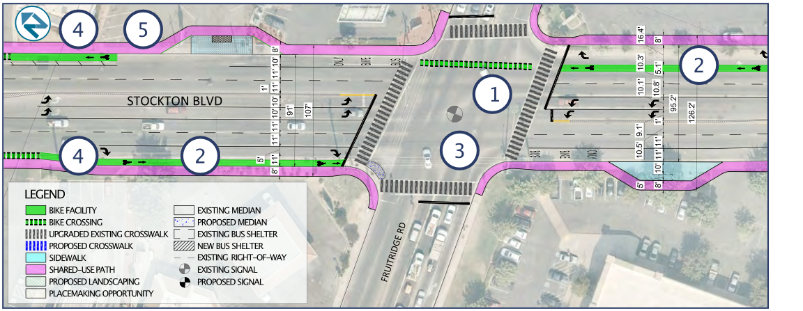
  • The plan acknowledges the challenging intersection of Stockton Blvd/34th Street/R Street as a “unique challenge” (page 13), but doesn’t even suggest solutions. I believe that the only way to make this intersection safe is to either restrict R Street or 34th Street, or to construct a flyover for light rail, similar to that for 19th Street, Watt Ave, and Sunrise Blvd. Yes, the expense of any of these might be beyond the scope of this plan, but eliminating this issue from the plan makes it difficult to compare the relative cost and benefit of other solutions.
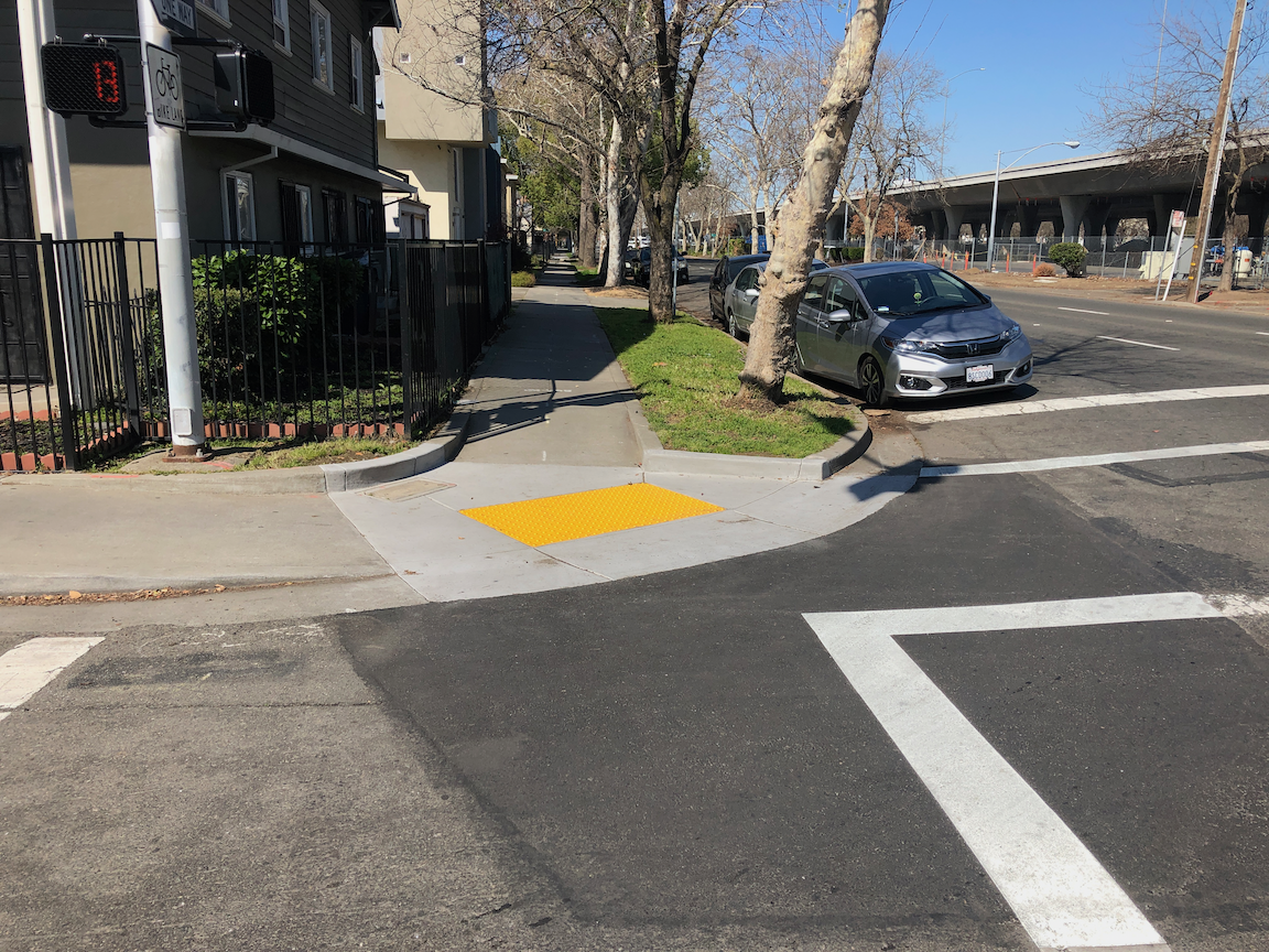
  • On page 36, a diagram shows a bike lane eastbound on T Street to the right of a dedicated right hand turn lane. Bike lanes should never be to the right of dedicated turn lanes unless there is a bicycle signal head to create an exclusive bicyclist phase, which the plan does not propose. This must be fixed.
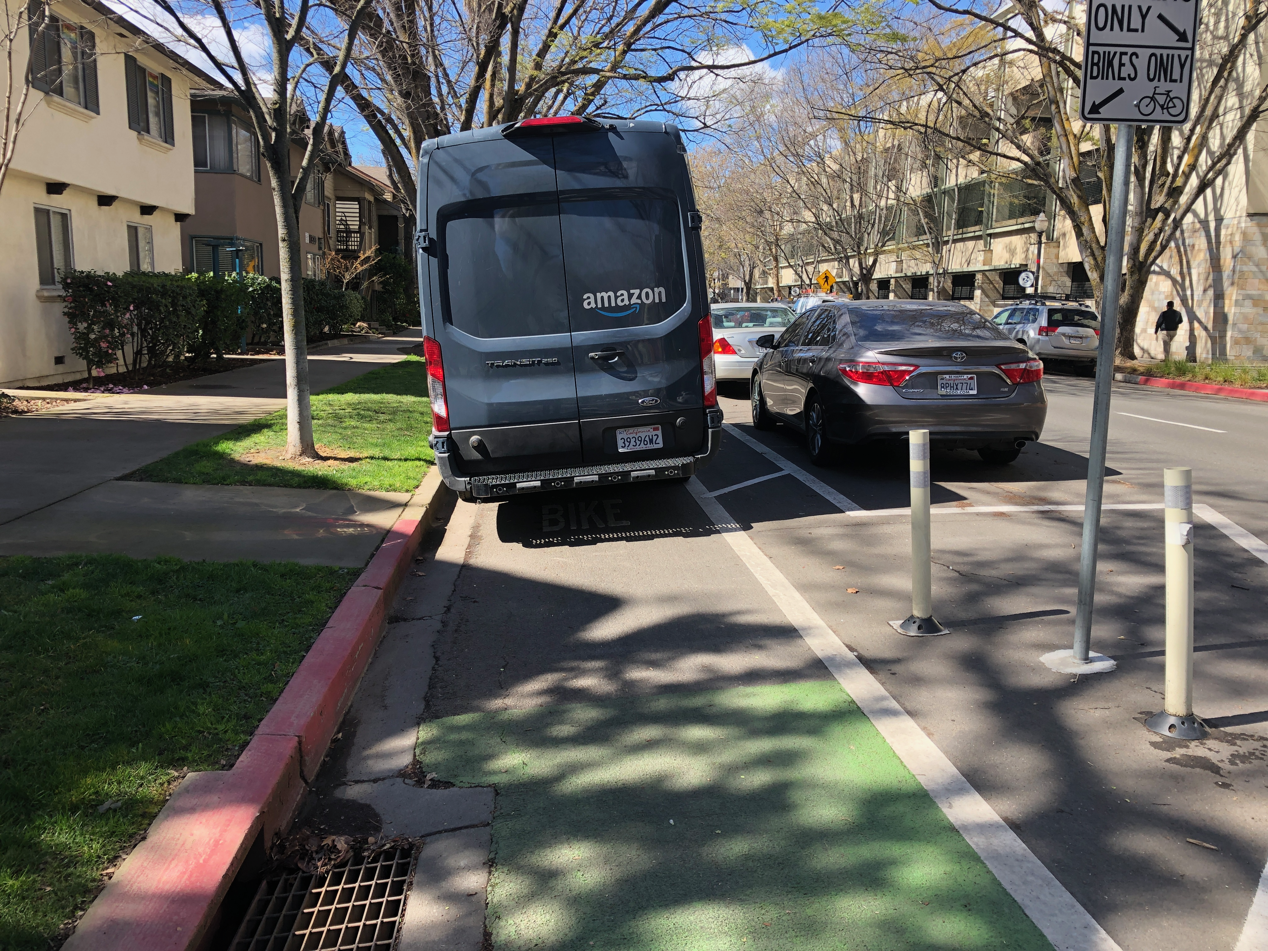
  • Shared bus and bike lanes will be a new concept for the city, and region. I support the implementation of these, and have used them in several other cities where transit frequency is not high. But they should be considered a pilot. If they don’t work out for bicyclists, and bus drivers, in this region, how do we fix it?
  • The flared intersection at Stockton Blvd and Fruitridge Road is preserved in the plan, but this is completely inappropriate. Flared intersections are always more dangerous for people crossing the street. The roadway width at the intersection, shown on page 41, is 90 feet. Crossings of this length cannot be safe, no matter what the length of the pedestrian cycle, without a pedestrian refuge median (with push buttons unless the pedestrian crossing is already on auto-recall). Double left hand turn lanes are dangerous for drivers and everyone else, as driver attention is focused on the vehicle beside, and not the roadway ahead, so these should be reduced to single left turn lanes. The right hand turns lanes should probably be eliminated, unless a traffic study shows conclusively that traffic would not clear during a signal cycle without them. The upshot is that this intersection should be completely reconfigured, not just tinkered with.
  • The plan does not indicate which intersection signals and signalized pedestrian crossings will be on auto-recall, or not. There is probably no justification for pedestrians activation buttons at any location on the corridor (pedestrian crossings should have auto-detection), but if there is, these should be called out clearly in the plan.
  • The plan shows most intersections as having skipped (dotted) green bike lanes striped through the intersection, but a few do not. They should be used everywhere. For the protected legs of partially protected intersections, the striping should be continuous rather than skipped (dotted). MUTCD frowns on this, but it has been installed many places with positive safety outcomes.
  • Added item: No right turn on red prohibitions should never be used without leading pedestrian intervals (LPI). Otherwise, drivers turning will immediately come into conflict with walkers in the crosswalk. I don’t think this is being proposed in this plan, but just want to make sure.

The City of Sacramento Active Transportation Commission will consider the plan this evening (2021-03-18). I apologize for not posting this in time for you to consider my suggestions, and relay them to the commission, if you agree.

Stockton Blvd & Fruitridge Road intersection

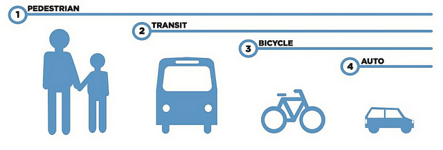
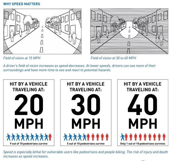
Added info: There was a discussion about the prioritization of different travel modes during the SacATC meeting this evening. It reminded me of one of my favorite graphics about transportation modes, from Chicago Department of Transportation. I think this is the right answer for Stockton Blvd, and for nearly every other roadway.

Vacant buildings

I find it interesting when something I’ve been thinking about but not written about suddenly shows up in Twitter and news media. Specifically, vacant buildings. Not talking about buildings that have been vacated during the pandemic, which may or may not see future use, but buildings that were vacant pre-pandemic, oftentime for years. The Sacramento central city has a lot of vacant buildings, most of them commercial spaces such as offices and warehouses, but some housing and retail as well.

The CityLab article The Case for a Duty to the City raises the issue and possible solutions to empty and underutilized buildings. It was highlighted in a Strong Towns UpZoned podcast “If you have a property in the city, you should not leave it empty.”, which brought me to it. And then today an article in the Sacramento Business Journal Cassadyne plans 50-unit apartment project in Midtown Sacramento (sorry about the firewall), about replacing empty parking lot with housing and an unused warehouse with parking.

I don’t have a solution for unused/underused/vacant buildings. Certainly the city should do everything it can to encourage adaptive reuse of functional buildings, or replacement when the building is no longer functional or can’t be repurposed for any use that is economically viable. But I’m also mostly a libertarian about property use, believing that people should do what they want with their property (while still not believing in the whole concept of private property). So I don’t think the city should force any particular development or use on a property owner, but sending economic signals that letting a building sit vacant is not in the best interest of the city, that is a valid function of a city.

Vacancy taxes or fees are one of the actions that has been proposed in other cities, particularly cities in Europe. I have mixed feelings. These might turn a project that is barely viable for a property owner into a decision to sell the land to a bigger developer who might be even less likely to move forward with productive use. So if there were to be a vacancy tax in Sacramento, I’d want an exclusion for any property that is owned by an individual rather than a corporation, or properties that are only a single traditional parcel (that has not been aggregated into a large parcel). That might actually encourage corporations to shed their small properties back to the market, so they could be picked up by smaller infill developers. More about small versus large developers, and preservation of traditional parcels, in a future posts.

Not knowing much specifically about this development proposal, I tend to think that the developer is providing too much parking, which will be underutilized, and which will promote vehicle ownership and use. But… I don’t think the city should prohibit that. It should, however, send a message that unproductive uses such as unneeded parking will have a cost, some sort of tax or fee on land used as parking. Or requiring that parking be unbundled from rent. Or requiring that the parking be available to the public through metering. Some policy that sends a message that excess parking is a societal harm rather than something to be promoted.

What about mass murder?

I will pause for a moment my mission to publicize and formulate ideas that make for a more livable place, more walkable, more bikeable, with effective transit, a diverse range of people, and jobs close to home.

The city, and the streets, are not safe for many people, not just because of traffic violence, but because of all types of violence. The last two years have seen a rising awareness that Blacks are not safe in public space, subject to oppression by law enforcement and violence in the places they live, and on the streets they use. What was once the problem of ‘driving while Black’ is now obviously the problem of ‘walking while Black’, ‘bicycling while Black’, and ‘existing while Black’. The same is true, to perhaps a slightly lesser degree, for Latinx. Hatred of trans people is growing, and they are unusually subject to violence. And now it is becoming clear that it is also not safe for Asian American Pacific Islanders (AAPI).

The incident in Georgia was probably a racial hate crime, but whether it was or not, it was a crime against those who died, and against society. Misogyny is also a hate crime. White supremacy is also a hate crime.

We have become a society where many people encourage the arming of everyone including mentally unstable individuals (usually white males, but not always), and they then try to absolve them when they act out. The former president encouraged hatred of ‘others’, meaning anyone not a white male, but focusing on people of color. The Republican party has long been the defender of the idea that the 2nd Amendment and the ‘right to bear arms’ is more important than all other amendments, and the rest of the constitution, and life itself. If people are not safe from gun violence, particularly white supremacy-fueled gun violence (by individuals and under the color of law), then all other freedoms are moot. The former president has blood on his hands on this one, and so do all his supporters, and so do all of the people who have opposed restrictions on gun ownership. Gun ownership in urban places is a pox on our humanity.

I will continue to be a voice for livable places. I appreciate every day the work of people to make those place safe and welcoming for everyone. I often think that I should join those voices in a more active way, but I also see that there are now many such voices, but still only a few voices for more livable places, and I feel like I need to continue to be one of those voices. We must adapt places and build places where the transportation network supports affordable housing for everyone, and affordable housing supports an effective and equitable transportation network. That is my mission. But I know that my work is for naught if people are not safe in those places.

more housing, less parking, part 2 central city SE

This is the second of the four quadrants of Sacramento central city, bounded by Capitol Ave on the north, Broadway on the south, 16th Street on the west, and Alhambra Blvd on the east.

Please see my previous post, more housing, less parking, for background information, and the southwest quadrant.

The graphic is below, but more useful will be the ArcGIS Online WebApp Sacramento parking & empty. Red is surface parking, orange is empty parcels.

The slideshow below shows many of the surface parking lots in this quadrant of the central city. It may include photos of parcels that contain a building but also have excess parking.

The next slideshow shows many of the empty lots in this quadrant of the central city.

It turns out that compiling the data, including parcels and photos, it quite time consuming, so the other two quadrants of the central city will be a while in coming, but I’ll be adding several posts about what I’ve learned, and the opportunities.

AB 550 allows speed cameras

AB 550, by Assemblyman David Chui, would allow the use of Automated Speed Enforcement (ASE, or speed cameras) in certain circumstances. I can’t point you to the language for specifics, since the legislative website has not been updated yet. You might call this a gut and amend bill, but since the original subject was ‘pedestrian safety’ it is really more of an amend.

The bill would establish a pilot program, which local transportation agencies could participate in. It would not start until July 2022, more than a year from now, in order for CalSTA (California State Transportation Agency) to develop an implementation plan. The program would rest with Caltrans and local transportation agencies, not with law enforcement agencies, which is a critical distinction to reduce the use of discriminatory pretext stops by law enforcement.

This legislation for ASE is a key component of the Vision Zero movement: “Managing speed to safe levels.”

It has long been my theory that most fatal crashes, whether the victim is a driver, passenger, walker or bicyclist, are caused by egregious speeders, drivers who travel more than 10 mph over the speed limit, the sort of people that CHP occasionally catches going 120 mph on the freeway, and is the same person driving 50 mph on a residential street. If that person is getting repeated automated speeding tickets, then they (he) can be targeted for more serious consequences like loss of freedom and loss of vehicle. Of course loss of vehicle probably requires other law changes, but this bill is at least a start.

When the bill language is available and hearing scheduled, I’ll post again. Keep an eye out here, or Streetsblog, or Twitter.

Streetsblog SF: Lawmaker Tries Again on Automated Speed Enforcement

from Streetsblog SF, original source unknown

9th St update

Things have changed again. The construction zone on the east side of 9th Street between K Street and L Street has changed again. The east parking lane and east travel lane are now dedicated to the construction project, the general purpose lane has been shifted right into the west parking lane, and the combined pedestrian/bicyclist bypass is now in what was the right hand general purpose lane.

One the plus side, detectable strips have been added to the left side of the bypass, which are required to provide protection from trip and crash hazards presented by the fence bases. Photo below.

detectable strips along bypass on 9th St

The entrance to the bypass is still awkward, too narrow and poorly signed. There are still corrections to be made.

entrance to pedestrian/bicyclist bypass on 9th St

Previous posts: 9th Street update, 9th St fixed, sort of, and 9th St blocked by construction.

curb ramps

While walking in the central city today, I saw this brand new curb ramp on the southwest corner of X Street and 24th Street.

new curb ramp, southwest corner of X Street & 24th Street

Why, why, why, did the city put in a diagonal curb ramp when they should have put in a two perpendicular ramps? Though I’ve searched in vain through city documents looking to see what the criteria is for a single ramp per corner versus two ramps per corner, I have heard it said by city staff that the single ramps are for residential neighborhoods and the two ramps are for urban neighborhoods. This is definitely an urban neighborhood setting, with both 24th Street and X Street being arterials. Yet the city put in a single ramp. They call this a ‘single flare curb ramp’. What should have been installed here is a ‘standard curb ramp’. The city diagrams do not show exactly this situation, where there is a sidewalk buffer (planter strip) on X Street, with an attached sidewalk on 24th Street, but the diagram below is the closest to the situation.

If the city development code does not specify that single, diagonal ramps should be used only in purely residential situations (if even there), it should be modified to be so.

2021-03-12: Adding a photo that better shows the context for this diagonal ramp. This is the southwest corner, X Street to the right and 24th Street to the left. There is space for perpendicular ramps. Of course this would have been a great location for a curb extension (bulb out) on both 24th Street and X Street, but yes, that would be significantly more expensive and might involve drainage issues.

curb ramp at southwest corner of 24th St & X St

2021-03-17: Adding a photo of a new curb ramp in the same area of town, at 22nd Street and W Street, showing the correct perpendicular curb ramps. It isn’t that the city doesn’t know how to do it right, it is that they chose not to at the intersection of X Street and 24th Street.

perpendicular curb ramps at 22nd Street & W Street

use Amazon? – support this!

This afternoon I was walking along P Street, not riding my bicycle, when I saw this Amazon delivery van parked in the separated bikeway (cycletrack) just past 13th Street.

When I asked the driver why he was in the bike lane, he said there was nowhere else to park. But in fact there is a cross-hatched, implied no-parking, area just behind the photo on 14th Street, not more than 30 feet from where the van is parked. I can’t show you an aerial of this because the parking has been reconfigured since the last historical Google Earth imagery without leaves on trees, but tomorrow I’ll take a ground photo and add it here. There were also several empty parking spots on 13th Street both north and south of P Street, but apparently this was too far for the driver to walk.

Once making several deliveries, the driver finally left, traveling down the separated bikeway all the way to 13th Street. I reported the parking violation to the city’s 311 app, but of course the van was gone before they could respond. However, I think it is important for everyone to report these violations, otherwise the city can claim it was not aware of the situation.

This is the Amazon attitude, that our deliveries are more important than public safety, and if we actually get caught, the ticket is a small price for our way of doing business, which is raking in the big bucks. So, please think about this photo the next time your order from Amazon. I am not saying Amazon is the only guilty party, other delivery services do similar things, though Amazon seems to be the most brazen. And it is partly the city’s fault. When they repaved and restriped P Street to create the separated bikeway, they could have created delivery spots on both the 15th-14th block and the 14th-13th block, but they did not.

2021-03-12: Adding photo better showing context for the illegal Amazon parking. On the right is the separated bikeway that was being blocked by the Amazon driver. On the left is the crosshatched area that sets off diagonal parking on 14th Street. This morning it was being used by an exempt vehicle, perhaps CADA, but when the Amazon van was there, this was empty and available for delivery.

the VZ solution we won’t talk about

The one thing that no one in the transportation advocacy community wants to talk about is speed-limiting vehicles. Speed-limiting means that vehicles cannot operate over the speed limit selected for a section of roadway. The technology for doing this is largely already in place on modern motor vehicles, as they already monitor their speed and already have available information about the speed limit on the street they are on. Older vehicles of course don’t, and would need to be retrofitted.

Why speed limiting? Because it is a simple solution that cuts through all the other discussion and contortions and expense of other solutions. Some people think education is the solution, as though all the education to date has done any good. Some people don’t want any traffic laws enforced, because ‘freedom’, meaning of course the freedom to operate a vehicle recklessly and kill people. Some people think that the solution is to redesign roads so as to prevent speeding. I’m not against that solution, but our mis-designed transportation system has a value of trillions of dollars, and fixing it will require trillions of dollars. We could spend our money that way, but why when we have so many other good causes to spend on. Vision Zero efforts are admirable, at least when they don’t have the involvement of law enforcement, but there has been very slow progress or regression in the United States because the engineering profession and law enforcement really don’t believe in the idea, giving it lip service while trying to subvert it.

Speed kills. It increase the severity of crashes, making severe injury and fatality more likely. It also increase the frequency of crashes, because drivers have less time to react and avoid, or slow before impact. You have all seen a version of the graph below, and it is important to remember that at every speed, speed is a contributing factor.

Speed limited does not mean changing posting speed limits, though it turns out that reducing speed limits does indeed reduce traffic speeds and reduce crashes and injury severity. However, speed limits are not set to the design speed of the road, but lower than than. As a result, drivers are encouraged by road design to speed, while fingers are wagged and tickets are written. But the problem is not solved. Crashes and severe injuries and death continue apace, or increase in the case of this last year.

With speed-limiting, no vehicle goes faster than the speed limit. If there are no crashes, maybe it gets increased a bit. If there are crashes with severe injury or fatality, then it gets reduced. We don’t need to change speed limit signs, we just change the permissible speed which vehicles respond to and follow.

Of course we should redesign streets to make them friendlier and safer for walkers, bicyclists, transit users, and drivers for that matter. But in the meanwhile, I want no one to die or be seriously injured on the streets and roads we have. Speed-limiting is the solution.

It is worth pointing out that designers and manufacturers of autonomous vehicles don’t want this to happen. They are assuming they will be allowed to violate speed limits, because they know that their primary target driver audience, young aggressive males, won’t buy vehicles that go the speed limit. They are just hoping no one notices that they are going to bypass this, and probably will get away with it.

more housing, less parking

I have been gradually compiling data on two types of properties that could be developed into housing, or mixed use, removing unproductive uses such as surface parking and empty lots. The data at the moment is just the southwest portion of the Sacramento central city, bounded by Capitol Mall/Ave on the north, Broadway on the south, Sacramento River on the west, and 16th Street on the east.

I am not claiming high accuracy. The polygons are parcels from the Sacramento County parcel layer, selected using ArcGIS Imagery basemap, with consultations to Google Maps and Google Earth (the historical imagery allows selection of views without leaves on the trees, making it much easier to see what is on a parcel). I am sure I have missed some parcels, and included some that should not be. Nevertheless, I think the pattern is worth thinking about. Parcels that contain significant parking but also contain a building are not included, though obviously when counting parking, it is important. And, the map does not include street parking or structured parking. If those were included, the map would be a mass of red. There is a remarkable amount of structured parking (often called parking decks), both freestanding, and layered into other buildings.

I have not distinguished who owns these parcels. Probably about half the parking is owned by the state, and the rest by private parking companies. Of the empty parcels, it is less clear, but there is a mix of public (state and city) and private. It would take a great deal of time to determine ownership in order to code these differently. Maybe in the future, but I’m not sure this is a significant issue.

The graphic is below, but more useful will be the ArcGIS Online WebApp Sacramento parking & empty. This is my first experiment with presenting information through a WebApp map, but I realized that people would otherwise be ruining their eyes trying to parse out the polygons of surface parking and empty lots in the static map. Red is surface parking, orange is empty parcels.

So, why the data compilation. There are a significant number of empty parcels in the central city, all of which could be housing instead of empty. And every surface parking lot could be and should be developed into a more productive use. By productive, I mean something of direct use to humans instead of cars, and more productive of sales tax and property tax. Our property tax system values empty lots and parking lots are virtually zero, meaning they contribute little to our tax base needed to provide services. I’ll say more about this shortly.

The slideshow below shows many of the surface parking lots in the southwest quadrant of the central city. It may include photos of parcels that contain a building but also have excess parking.

The next slideshow shows many of the empty lots in the southwest quadrant of the central city.