- Sustainable Communities (KVIE Studio Sacramento 2013-08-31); with Mayor Christopher Cabaldon of West Sacramento and Bruce Starkweather
- Authorities announce DUI crackdown in Sacramento area for Labor Day weekend (SacBee 2013-08-30)
- Rancho Cordova wants to make sidewalks problem of property owners (Sacramento Business Journal 2013-08-30)
- Vision for 16 Powerhouse: ‘Sustainable, green, luxurious’ (Sacramento Business Journal 2013-08-28); note inclusion of bike racks
- Opinion: On the merits, McKinley Village deserves our support (Sacramento Press 2013-08-28)
- More older drivers, fewer teens behind the wheel in California (SacBee 2013-08-26)
Author: Dan Allison
Dan Allison is a transportation advocate in Sacramento, CA. Dan dances and backpacks, as much as possible.
removing Business 80?
William Burg started a wonderful conversation on Facebook about removing Business 80 from B Street to Hwy 50, returning the traffic to surface streets. The post is now up to 115 comments, and still going after two weeks. I believe that you have to be a member of Facebook to view this thread, but don’t need to be friends with William Burg (though you should). I agree with Jared that this topic should be amplified for Sacramento Press.
Some people think that this is crazy thinking, it will never happen. I think it will. Why? Not because it is a good idea, though it is, but because we will not be able to continue to keep these freeways open and in decent condition with future transportation funding. Caltrans and others have just spent or are spending $202 million on Hwy 50, basically just to keep in it usable condition. Not to improve it in any significant way, but just to keep it working. Where is the money going to come from to maintain Hwy 50, Interstate 80, Interstate 5, and Business 80 (Capital City Expressway)?
the magic water fountain on M Street

In my previous post, I complained about the non-functional water fountains at SacRT light rail stations, but in doing so, I remembered that I’d never posted about the water fountain on M Street in Sacramento. Herewith is my paean to the M Street water fountain.
In a tiny triangle park at M Street and 48th Street in East Sacramento is a wonderful thing, a public drinking fountain. Not only is there a drinking fountain, but also a decorative fountain, and benches, and flowers, and shrubs, and a patch of grass. I stop here on every trip, whether I’m thirsty or not, just to celebrate this little corner. Sometimes I’ll stop and lie on the grass, or sit on the bench and enjoy the fountain. Other times, it is just a quick drink and on with my trip. I’ve seen mothers here letting their kids play, and retired folks just passing the time. There is always a bowl beside the fountain for dogs to have a drink as well.
a thirst for working water fountains

On Wednesday evening, I rode from Woodside K-8 School in Citrus Heights to the Sunrise SacRT light rail station, and then caught light rail home. As I passed Sunflower in Fair Oaks, I thought of stopping for a drink of water, but decided to just head on down the hill to the drinking fountain on the north side of the red Fair Oaks bridge. It was not working, covered with plastic. I continued on to the Sunrise station, where both water fountains are not working. I suspect these have not been working for years, they look abandoned. By this time, I was pretty darn thirsty, and the long wait in the evening for the next light rail train was not pleasant. Even if I’d wanted to go to a convenience store for something to drink, there aren’t any close to that station.

green wave
A “green wave” is a traffic signal sequence set so that vehicles will encounter green lights for some distance, so long as they are traveling at the selected speed. A green wave can also be set for bicycle speeds, though it very rarely has been, and never in Sacramento.
To some degree, all signals are set this way, though the degree and distance of sequencing varies widely. Many of the east-west streets in the Sacramento grid have signals set for motor vehicles, and when traffic is not congested, it may be possible to go all the way across downtown and midtown on green lights, for example on J Street. Very few north-south streets are set this way, I can think of only the 15th & 16th couplet, and the 9th & 10th couplet. At intersections with the east-west couplets, these north-south couplets seem to have their green wave broken. Only if the grid spacing and the selected speed calculate out is it possible to have a green wave in all directions. Sadly, many signal sequences in the Sacramento region are set above the posted speed limit, encouraging drivers to speed so that they make all lights.
bike storage at light rail
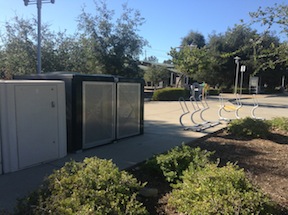
If you are a light rail user, you may have noticed bike storage lockers at some of the stations. Two types of lockers exist:
- rental lockers at 19 SacRT light rail stations, which are listed on the SacRT “Biking with RT” webpage
- on-demand lockers at 3 SacRT light rail stations in Folsom, plus the Folsom Pedal Stop bike station
The rental lockers work well for people who routinely commute the same route to and from work, and are leased for 6 months or 13 months at pretty reasonable rates. The downside to rental lockers is that they can be used by only one person, and are empty when not in use by that person. Mike Mattos, SacRT Chief of Facilities & Business Support Services Division, said that these lockers were mostly purchased at the time of rail extensions, and they are repaired and replaced from operating funds. They move lockers from one station to others as demand changes. They have explored on-demand systems, but have not installed any because they don’t feel that any vendors so far meet their criteria. He pointed out that the downside of on-demand systems for typical commuters is that they don’t then have a guaranteed space at their station.
News summary August 25
Carnage
- Coroner identifies man killed by light-rail train in Rancho Cordova (2013-08-25)
- UPDATE: Man struck and killed by train in midtown (SacBee 2013-08-21)
- I’m never sure whether to list these walker vs. train and light rail collisions – do they have anything to do with a safe transportation system or not? Since there is rarely followup information in the media, except sometimes the name of the victim, most of these kind of incidents remain ill-defined, and their significance unknown.
Big Box
- Biz leaders cheer city’s big-box vote (Sacramento Business Journal 2013-08-21)
- Sacramento City Council eases restrictions on ‘big-box’ stores (SacBee 2013-08-20)
- Sacramento considers changing big-box rules (Sacramento Business Journal 2013-08-20)
- City Council to vote on superstore policy tonight (SacBee 2013-08-20)
- Editorial: City should dump ‘superstore’ rules (SacBee 2013-08-20)
- [Poll] City to vote on big-box ordinance (Sacramento Press 2013-08-20)
- Sacramento Stonewall Democrats Oppose Repeal of Superstore Ordinance (Sacramento Press 2013-08-20)
- The Walmart fallacy (Sacramento News & Review 2013-08-19)
Other
- Davis housing project must overcome city’s anti-growth streak (SacBee 2013-08-23)
- Another View: McKinley Village will be an asset to Sacramento (SacBee 2013-08-22)
- Caltrans plans project to ease Capital City Freeway bottleneck in east Sacramento (SacBee 2013-08-22)
- California’s Unusual Plan to Cut Greenhouse Gases (Atlantic Cities 2013-08-19); the SACOG plan for the Sacramento region is one of three discussed
- Exposures: I Care: Bicycle Kitchen serves up help on a shoestring budget (SacBee 2013-08-19)
News summary August 18
- Open Letter to Mayor Johnson and City Council – Do Not Repeal the Superstore Ordinance Sacramento Press 2013-08-18
- Sacramento-area officials seek to take over, develop Jackson Highway (SacBee 2013-08-18)
- Regional transit looks at possible funding shortage with growth surge (Sacramento Business Journal 2013-08-16)
- End of Summer DUI Crackdown- SacPD (Sacramento Press 2013-08-15)
- West Sac awards contract for Barge Canal bridge (Sacramento Business Journal 2013-08-14)
- Feds delay ruling to withhold California’s mass-transit funding (SacBee 2013-08-16); Editorial: Obama official needs to free up transit money (SacBee 2013-08-14); Billions in federal transportation funds riding on California’s new pension law (SacBee 2013-08-13)
- OPINION: Repeal of ‘Big Box’ threatens regional sustainability (Sacramento Press 2013-08-14)
- Viewpoints: Problems with McKinley Village proposal begin with geography (SacBee 2013-08-14)
- GearUp Cycle for Youth Ride, October 12
- RT breaks ground on new Franklin Boulevard station (SacBee 2013-08-14); Sacramento RT starting work on blue line extension (SacBee 2013-08-13)
- The MLS promenade: Whether Sacramento’s best step is toward downtown or the suburbs (Sacramento Press 2013-08-12)
- Addiction to Bike Polo: Dealing with Obsession (Sacramento Press 2013-08-12)
Choosing streets to bike

The first criteria for choosing streets to bike on is traffic speed. In the grid, nearly all of the streets are posted 25 mph, but traffic speeds vary widely from 20 to 40 mph. When a street is designed for 40 and then posted for 25, motor vehicle drivers respond by going 40. Again, this is a street design issue. I am not afraid of 40 mph traffic, and I am OK mixing in with it – I’m a vehicular bicyclist, but why, when I don’t need to? So I pick other streets.
First preference is quiet streets with a design or signing welcoming to bicyclists. Best example is M Street in East Sacramento, my usual route to and from Trader Joes, and also when I jump off the parkway at Sac State and continue into downtown/midtown. Streets like M are the closest Sacramento has to bike boulevards or neighborhood greenways.
Second preference is narrow streets without bike lanes. Why? Because the traffic moves slowly on these streets, sometimes below the posted speed. Since I’m now treating stop signs as yield signs, the more frequent stop signs on these streets don’t slow me down very much, there are few vehicles to take turns with except at two brief times of day. Parking along these streets helps a lot, particularly when it is diagonal, because parked cars create friction that slows drivers.
Third preference is streets with bike lanes. But often these are higher volume, higher speed streets. If I’m really in a hurry, these are the streets I use. Fewer stop signs and fewer signals make for a faster trip. In that sense I’m making the same decision as car drivers.
Choosing streets to walk

I walk a lot in midtown, going to and from various destinations such as the train station, nonprofits and agencies I work with, grocery stores, theatres, farmers markets, breweries, etc. I was thinking last night as I walked to and from Capital Stage about what streets I choose to walk on.
Almost all the time I choose to walk on two-way, two-lane streets. I rarely choose to walk on the multi-lane streets and the one-way streets, except for short distances as I zigzag to my destination. The two-way, two-lane streets are usually quieter, less traffic and traffic moving more slowly. I can relax more with the quiet, and I can look around more, paying more attention to everything around me and not just traffic.
Why is this significant?

