I wrote in March and May about the Marysville Blvd Vision Zero project phase 1: Marysville Blvd VZ Safety Project starts and Marysville Blvd VZ Phase 1 complete. Now for a closer look at phase 2. The city’s project page is Marysville Blvd Vision Zero.
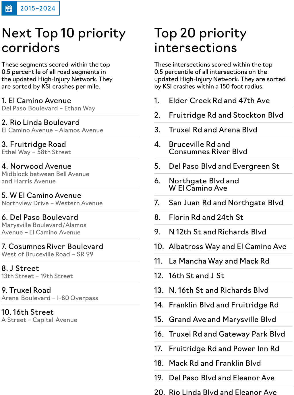
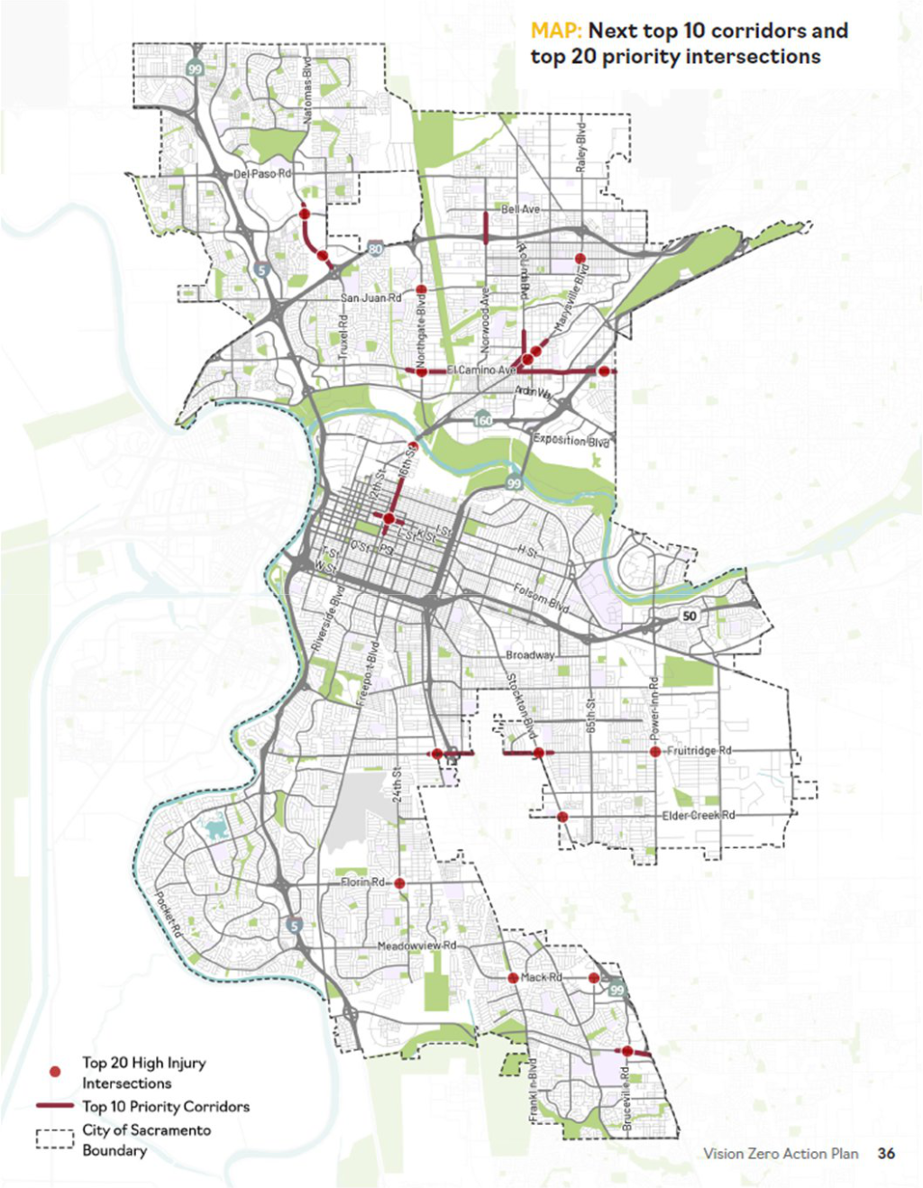
Marysville Blvd is one the 2018 Vision Zero Action Plan top 5 corridors. The 2026 Vision Zero Action Plan Update (page 33 list and map) draft includes Marysville Blvd south of Arcade Blvd as part of the Del Paso Blvd top 10 corridor, and two intersections. It also includes the intersection of Marysville Blvd and Grand Avenue in the top 20 intersections, which is within and central to the Marysville project. The Marysville Blvd Vision Zero project is the result of the 2018 identification.
The city has a preliminary design for phase 2, but engineering is not complete, nor is funding available. That means that citizen input can improve the project. Phase 2 would extend the project north from Grand Avenue to North Avenue, and south from Nogales Avenue to Arcade Blvd. There is no official public outreach at this time, but you can always email the city with your concerns and ideas: MarysvilleVZ@cityofsacramento.org.
The project page has a list of ‘Project Features’:
- Road Diet: A road diet is a reduction of a travel lane to slow down traffic and improve safety.
- Bicycle Lanes: Upgrading existing bike lanes to protected bike lanes.
- Pedestrian Safety: New pedestrian signals and controlled crossings.
- Infrastructure: Pavement repair and sidewalk improvements.
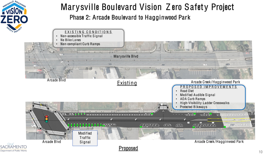
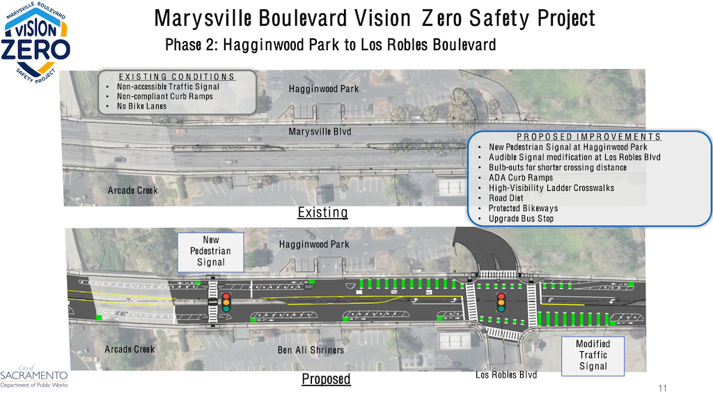
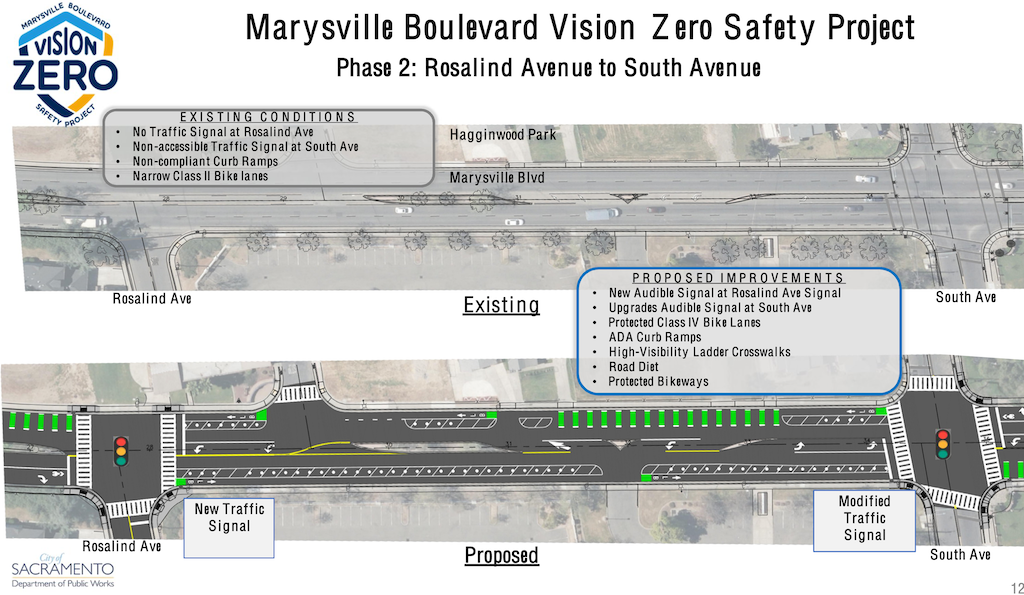
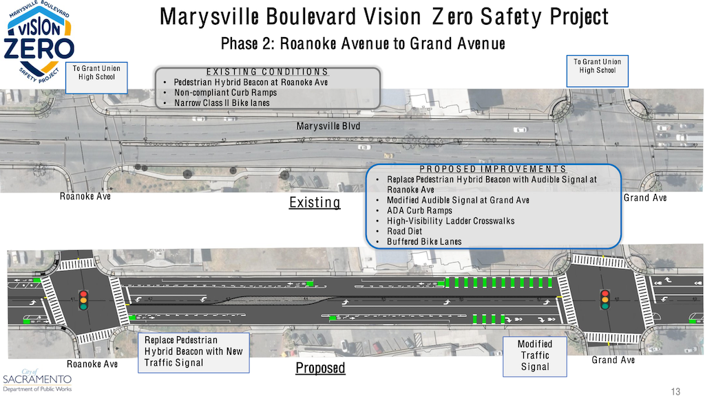
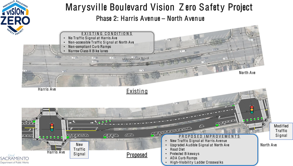
Five maps of the project area were provided in a presentation to SacATC 2025-09-18, and these are shown below, south to north. There are gaps in these maps, but I think they serve to show the kinds of changes proposed. There were preliminary designs, final designs and engineering are now being developed by a consultant.
My comments on the project start below the maps.
My Comments
Sidewalks: As is typical of all city projects, sidewalks are neglected. Though ‘sidewalk improvements’ are in the features list, not a single location is identified for sidewalk widening. Most of the corridor has sidewalks that meet the minimum acceptable width, but they do not meet any criteria for encouraging people to walk. The sidewalks are cut by dozens of sloped driveways, and no mention is made of bringing these driveway crossings up to ADA/PROWAG standards. ADA/PROWAG standards require that either the driveway slope be in a sidewalk buffer (preferred) or that the sidewalk ramp down and then back up across the driveway (acceptable but not preferred). ADA curb ramps are specified, but most are angled to the sidewalk and crosswalk, not perpendicular, which makes them more difficult for vision limited people and mobility devices users.
Crossings: High visibility crosswalks are specified at every intersection. But most of the intersections on the corridor are skewed, the cross-streets not exactly matching each other as they would in a grid. This makes for longer crosswalks, and more difficult maneuvering for people walking and rolling, but there is probably no solution for this issue. The design diagrams mention upgraded audible signals at several locations. Unfortunately, the current city practice is to install ‘press or wave at’ pedestrian actuators, meaning that what were auto-recall pedestrian signals will now require action by walkers and rollers to trigger signals for crossing. This is a regression for walkers, and the effect is to speed motor vehicles and slow walkers.
Trees: Apparently existing trees, in a few of the medians, and rarely along the street, will be removed, in favor of generous turn lanes. This could be an oversight in the diagrams, but I suspect not. Though city staff said that trees would be preserved, the diagrams indicate otherwise. There is no place along the corridor where the design adds sidewalk buffers (planting strips) for new trees. Without ample tree coverage, this corridor will be hostile to people walking, and bicycling, particularly during the summer. If the city really wanted to enhance and encourage walking, the design would look much different that it does. It has become routine for the city to say that it will include trees in all projects, but the completed project have far fewer trees than were promised.
Signals: The project upgrades and adds traffic signals. Signals improve safety for people crossing at intersections, but they can also make a corridor very frustrating for driver and bicyclists if they are not timed correctly. I would suggest that the corridor have signals timing set to a ‘green wave’, where a bicyclist traveling at about 13 mph will see green lights. Of course signal spacing make logistically challenging, but it should be the goal.
Bicyclist facilities: A clear goal of the project is to provide bicyclist facilities, and to make them safer. This is great. However, hard concrete curbs are more appropriate in many locations than painted buffers and vertical delineators. They can’t be installed everywhere, and are less practical where driveway density is high, but they are best-practice. Wide painted buffers just waste roadway width that could be allocated to sidewalks and sidewalk buffers.
Driveway closure: No mention was made in the SacATC presentation of closing driveways. There are a considerable number of driveways which are abandoned, serving empty parcels, with whatever buildings were there, long gone. A few driveways are now blocked by buildings, so unusable no matter what. The city has a driveway abandonment and closure policy, which needs to be implemented on Marysville Blvd as part of the Vision Zero project. Driveways may be appropriate in some situations, but they are always a deterioration of the walking environment.
Arcade Creek crossing: The Hagginwood Park to Los Robles Blvd diagram (above) shows a ‘new pedestrian signal’ and crosswalk at Hagginwood Park. I am not clear about what purpose this serves. On the north side, it is not aligned with the walking entrance to the community center. On the south side it is not aligned with anything. It may be intended to be a crossing for the Arcade Creek trail, when it is eventually completed, but if so, it doesn’t make sense to put it into a near-term project for Vision Zero. Due to the hump of the Arcade Creek bridge, there is some visibility limitation for this crosswalk location. I think it would be better to close the excess driveways at Hagginwood Park, widen the sidewalk on the north side to accommodate bicyclists, and encourage people using the trail fragment to the north to cross at Los Robles Blvd.
No timeline for phase 2 has been provided. When a draft final design is completed and released, I’m sure I will have more comments.