City of Sacramento held the second of two workshops on the Neighborhood Connections element of the Active Transportation Plan on Wednesday at noon. About 40 people participated, and there were many questions and comments. I was not able to participate in the first workshop a week ago, but I imagine the content and discussions were similar. The presentation given during the workshop is available.
A draft plan (SacCity Neighborhood Connections Plan 2024-10) is available for public review and comment through December 1.
There are four appendices to the plan:
- Appendix A: Existing Conditions Technical Memorandum (which was previously available)
- Appendix B: Project List (is this a subset of the Transportation Priorities Plan list – not clear)
- Appendix C: Traffic Calming Toolkit
- Appendix D: Corridor Treatment Examples
You can comment in the body of these documents by using the Konveio tool (scroll down on the Streets for People Active Transportation Plan webpage to the box with a green bar at the top), or submitting by email to StreetsForPeople@cityofsacramento.org.
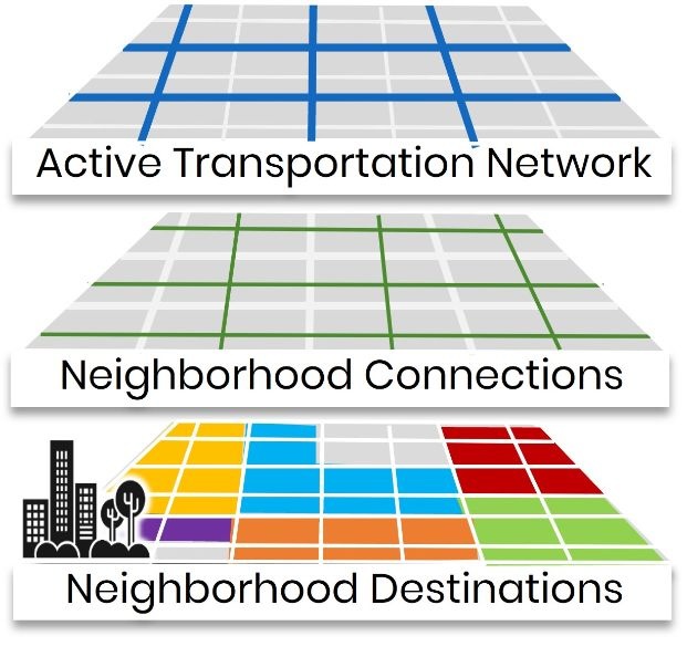
The Neighborhood Connections plan is “Focused on neighborhood streets, featuring traffic calming treatments to slow traffic and support more comfortable walking, biking, and rolling to neighborhood destinations for people of all ages and abilities”. It addresses minor collector and local streets (two of the seven functional streets classification FCS system), the middle layer of the diagram below. These streets in general do not have bike lanes or other dedicated bicycle facilities, but are rather what are referred to as Class III bikeways, with signing or marking but no separation or protection. These streets would have speed limits of 25 mph or less (20 mph should be the city-wide standard for these streets), and relatively low traffic volumes.
The city has said these streets would be designated in some way by markings, signing, or wayfinding signage, but the plan does not detail how they would be designated. Some of these streets currently have ‘bike route’ signs, indicating a Class III facility, but these are used on streets of such variable safety and comfort (level of stress) that they are pretty much meaningless.
The plan focuses more on design and specific streets, and is weak on policy. I don’t see anything in the plan which would prohibit the city or a developer from constructing a street that doesn’t meet the goals of the plan, and does not design in traffic calming measures.
The Active Transportation Network plan (which the city is also just calling Streets for People) has been separated from the Neighborhood Connections plan because the latter must be completed sooner to meet grant deadlines, and when both are complete, they will be unified as the Streets for People Active Transportation Plan. The Traffic Calming Toolkit is a different formatting of the traffic calming measures in the Neighborhood Connections story map, which I’ve previously written about. As I said, these measures are progressive and innovative. It was not clear to me that these apply only to the Neighborhood Connections streets, and not to the Active Transportation Network streets. Several of them should apply to major collectors and arterials. I’ll take a look at those again in another post. It is worth noting that the two plan parts are being developed by separate consultants, Neighborhood Connections by Kittelson & Associates, and Active Transportation Network by Alta Planning+Design.
Of the many questions and concerns asked during the workshop, a few interesting (to me) were:
- Q: will increased bicycling result in increased crashes, A: no, due to safety in numbers, and slower motor vehicles
- Q: is this related to emergency declaration? A: no
- Q: is this integrated with parking strategy? A: it is not, but an increase in bicycling will require increased bicycle and device parking, which the parking strategy does address
- Q: will all streets be marked? A: yes, but marking not determined
- Q: where will funding come from? A: almost all will be grant funded, so buildout is over a very long period of time, though some quick-build project may be completed earlier
- Q: what effect does AB 1216 (no sharrows on 30 mph and above streets) have? A: law applies only to ATP grants, but the city would not do that on any streets
- Q: are ten examples the ones to be done first? A: no, they are just examples of solutions in different contexts, meant to provide ideas
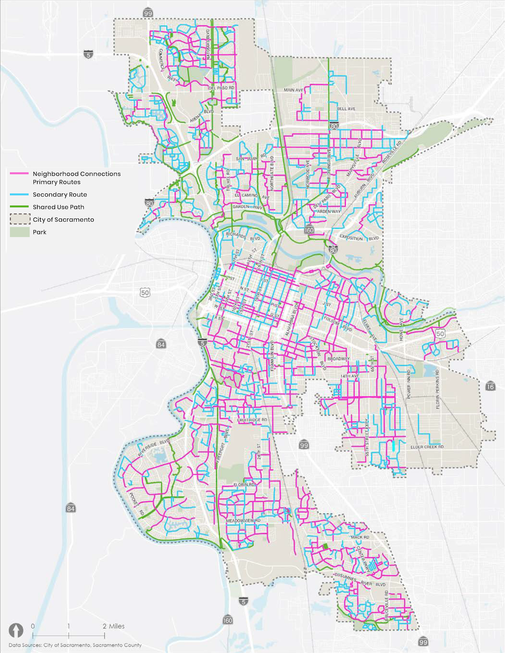
The map below shows the proposed Neighborhood Connections streets. The plan contains additional detail including route designations that will presumably be used on signing.

[…] is the section that covers arterial and major collector streets. Local streets are covered in the Neighborhood Connections Plan (2025-01), which has now be adopted by the city and will be incorporated into the overall plan […]
LikeLike
[…] with the quick build program. Most of the traffic calming measures in Neighborhood Connections (SacCity Neighborhood Connections) and and many of the traffic calming measures in Streets for People Active Transportation Network […]
LikeLike