This is Central City Mobility Project update #24.
For quite some while, the project on 19th Street had stopped at Q Street, but it is now continuing south to W St. White striping is done, there is some green paint but incomplete, curb and line colors for special parking is not started, and there are no vertical delineators. The block from Q Street to the light rail tracks is a buffered bike lane, due to a street dining area at Midtown Spirits. At the tracks, there are some swooping lines, that I think are intended to encourage bicyclists to cross the tracks at a closer to perpendicular angle, but it is not finished so I can’t tell if it being properly marked. The remaining blocks to W Street are parking protection separated bikeway.

The section from W Street to Broadway has not been worked on. As is true of most of the separated bikeways, it is on the left side. South of Broadway, 19th Street becomes Freeport Blvd and is two way, with the southbound bike lane on the right side. At the moment, there is nothing to indicate how and where a bicyclist would transition from right side to left side. The two blocks are devoted to general purpose (motor vehicle) lanes, and is not a comfortable place for a bicyclist to be.
In the design diagrams, the transition appears to be at W Street, with no particular accommodation for bicyclists. Though the design diagrams do not indicate operations, just striping and signing, it looks as though bicyclists will cross W Street on the east side, with the regular signal, and then 19th Street on the south side, with the regular signal. There is no indication that the bicyclist crossing 19th Street will be protected from left turning motor vehicle traffic by an exclusive phase. Green paint is not sufficient communication for most drivers, hard physical control is required, such as no left turn during the bicyclist movement. I suspect, based on city implementation in other locations, that it was decided that an exclusive bicyclist phase was ‘not practical’ because it would slow motor vehicle drivers a bit.
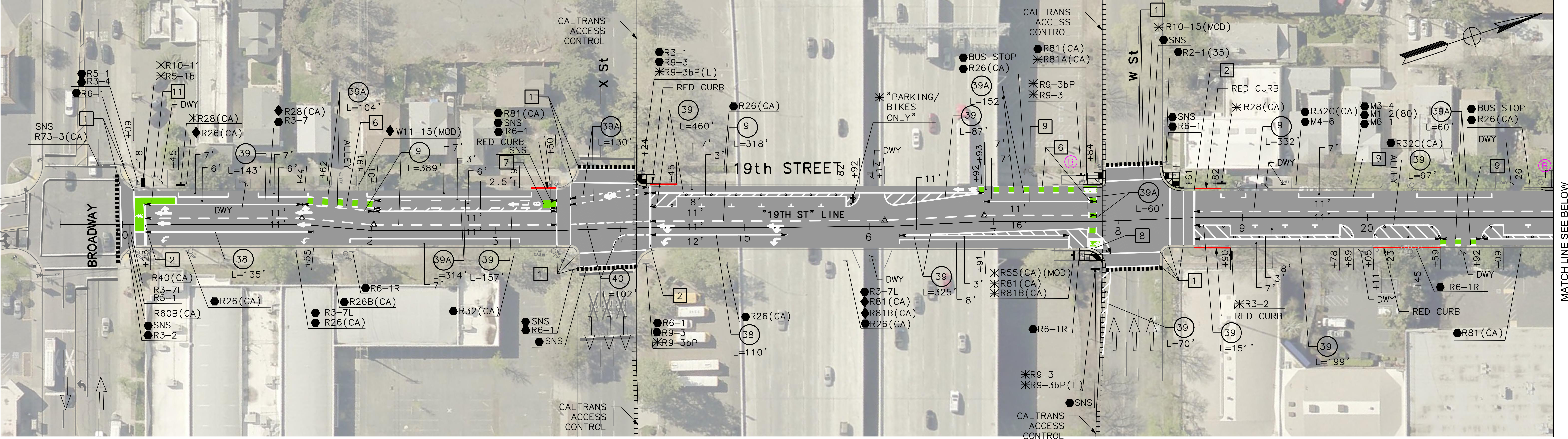
I believe that the city should develop and install signing specifically for bicyclists on the transition points, where a bikeway either ends or transitions to the other side. There is no indication that the city has done or intends to do this. The diagram indicates a R55(CA) (MOD) sign on the southeast corner, which is a mystery, since the standard R55 sign is ‘yield to uphill traffic’. Of course neither the federal MUTCD nor the California CA-MUTCD, which is similar, has much in the way of guidance or signage for bicycle facilities, since in the mind of FHWA and Caltrans, bicyclists are an afterthought. There are several note references around this intersection, several of which I have been unable to locate in the design document, but they must exist somewhere. Be aware that the city has ‘invented’ a number of traffic control signs that are not compliant with CA-MUTCD, so the excuse that there isn’t an official sign is just stonewalling on the part of the city.
I Street
There has been no work on I Street in quite a while, since the resurfacing, but there are new ‘no parking’ signs posted with control starting today, 2023-09-19, so perhaps work is about to start again.

I still don’t understand the logic of retrofitting marginally better bike lanes onto (not one, but 2!) busy arterial streets with bus service. The street will remain uncomfortable for most potential riders, albeit with some quality-of-life improvements.
To increase ridership, we need true high-comfort routes. For example, it looks like 20th street would have been a better choice–it carries very little through traffic. Spending money making a connection around the “Y” to Broadway in some good way, and improving the single set of cross street intersections up to I St, seems like it would have been a better use of money.
It also leads through the heart of the midtown entertainment district–much of 20th street is often closed to traffic anyway on weekends.
LikeLike
I do not know what the city’s selection criteria was, but I’ll speculate. Their idea is that high volumes of people just wanting to go a distance should all be on the same roadway, which means P, Q, 19th, 21st, 9th, 10th, I, J. That means one-way, two or more lanes roads, bus service, and separated bikeways. These are also the streets that wear out faster, so needed repaving, which is a good time to reallocate roadway width. The city has never really supported the concept of low stress biking routes or neighborhood greenways, for use by people who want local access, and who are not comfortable riding with very many cars. Or buses, for that matter, though buses have professional drivers and private motor vehicles have unprofessional drivers. M Street in east Sacramento is essentially a neighborhood bikeway, but the city has never done improvements to make that clear, and it is unwritten city policy that they will never again install traffic diverters (also called modal filters), on M or any other street. The city also loves stop signs and unnecessary signals, so parallel low stress routes are likely to have a lot of those, making them slower than the arterial streets. Many bicyclists have a different vision of what they want that the city does, and I’m certainly hearing a lot from them, in response to my Central City Mobility Project series.
LikeLike
Also, again unwritten policy, the city will not designate a street that regularly gets closed (or permanently, for that matter), as a bike route of any sort.
LikeLike
I guess we’ll see how these unwritten policies fare going forward. Frustration seems to be building in the neighborhood associations.
A car crash sent a vehicle onto the corner sidewalk in front of Phoebe Hearst Elementary this week, exactly at the spot where a parent was killed last year. There is a funded plan to reduce Folsom Blvd to 2+turn lane in that section, but who knows when it will get done? At this point we should just go out there with cones…
LikeLike