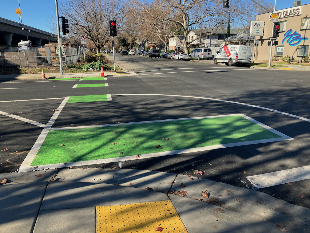
The 19th Street bikeway has been completed from W Street to Broadway. Only a half block of the two blocks is separated bikeway, and it is on the right side rather than left side as it is to the north. At W Street there is a bike box in line with the bikeway to the north, and a green dashed bikeway to carry the bikeway from the left or east side to the right or west side. The curved area shown in the photo does not have any sort of protection to reduce turn speeds, as is present on most turn wedges in the rest of the Central City Mobility Project.
The turn intersection involves a two stage turn for bicyclists, once to cross W Street to the south side, and then to cross 19th Street to the west side. There is no separate bicycle phase or bicycle signal face here. The pedestrian crossing phohibition here and lack of crosswalk indicates two things: there is no sidewalk on the south or freeway side of W Street, and that high speed turns from W Street to 19th Street are expected and encouraged. This project would have been a great time to add a crosswalk and pedestrian signaling here, and remove the prohibition, as both sides of 19th Street under the freeway have sidewalks, so a crosswalk would speed travel for walkers by offering two routes of travel. Bicyclists using the green dashed crossing of 19th Street have turning traffic at their back, which is somewhat unsafe but could have been made safer with an exclusive bicyclist phase or even a bicyclist signal phase. Since the signal timing favors W Street over 19th Street, it could have been possible to allow both a brief bicyclist phase and a turning phase.
19th St bikeway transition to right side
Crossing under the freeway, the bikeway is partly green painted and next to a travel lane, and partly parking protected bikeway to X Street. From X Street to Broadway, it is a regular door-zone bike lane. At Broadway, there a green bike box the full width of the street, allowing bicyclists to continue straight or turn left onto Broadway.
To summarize, the design is OK but could have been better.
For quite some while, the project on 19th Street had stopped at Q Street, but it is now continuing south to W St. White striping is done, there is some green paint but incomplete, curb and line colors for special parking is not started, and there are no vertical delineators. The block from Q Street to the light rail tracks is a buffered bike lane, due to a street dining area at Midtown Spirits. At the tracks, there are some swooping lines, that I think are intended to encourage bicyclists to cross the tracks at a closer to perpendicular angle, but it is not finished so I can’t tell if it being properly marked. The remaining blocks to W Street are parking protection separated bikeway.
19th St at Q St, buffered bike lane
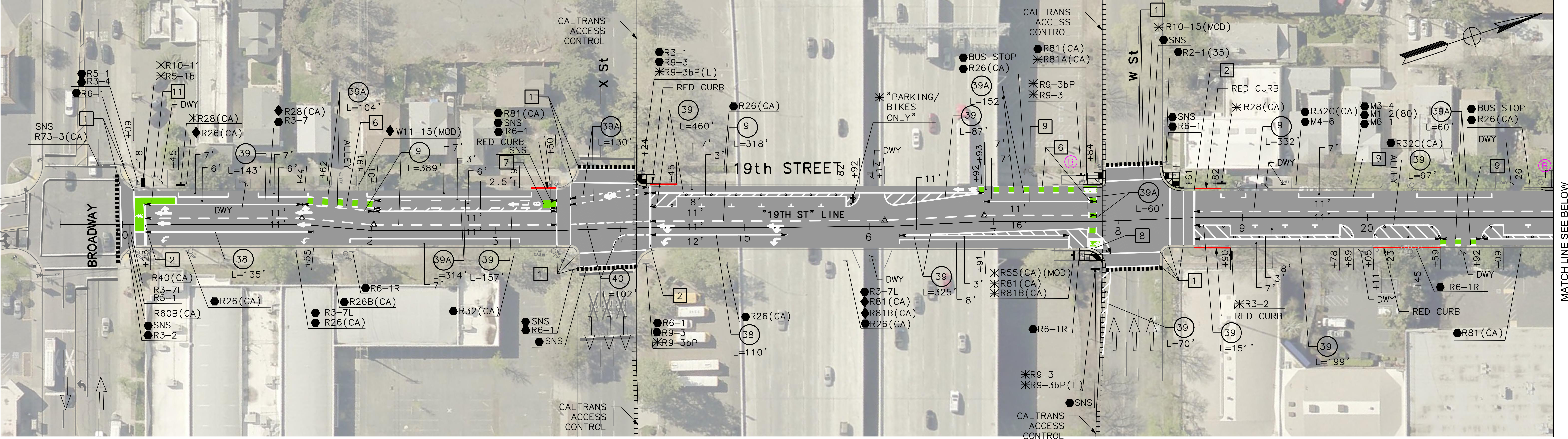
The section from W Street to Broadway has not been worked on. As is true of most of the separated bikeways, it is on the left side. South of Broadway, 19th Street becomes Freeport Blvd and is two way, with the southbound bike lane on the right side. At the moment, there is nothing to indicate how and where a bicyclist would transition from right side to left side. The two blocks are devoted to general purpose (motor vehicle) lanes, and is not a comfortable place for a bicyclist to be.
In the design diagrams, the transition appears to be at W Street, with no particular accommodation for bicyclists. Though the design diagrams do not indicate operations, just striping and signing, it looks as though bicyclists will cross W Street on the east side, with the regular signal, and then 19th Street on the south side, with the regular signal. There is no indication that the bicyclist crossing 19th Street will be protected from left turning motor vehicle traffic by an exclusive phase. Green paint is not sufficient communication for most drivers, hard physical control is required, such as no left turn during the bicyclist movement. I suspect, based on city implementation in other locations, that it was decided that an exclusive bicyclist phase was ‘not practical’ because it would slow motor vehicle drivers a bit.
19th Street from W Street to Broadway
I believe that the city should develop and install signing specifically for bicyclists on the transition points, where a bikeway either ends or transitions to the other side. There is no indication that the city has done or intends to do this. The diagram indicates a R55(CA) (MOD) sign on the southeast corner, which is a mystery, since the standard R55 sign is ‘yield to uphill traffic’. Of course neither the federal MUTCD nor the California CA-MUTCD, which is similar, has much in the way of guidance or signage for bicycle facilities, since in the mind of FHWA and Caltrans, bicyclists are an afterthought. There are several note references around this intersection, several of which I have been unable to locate in the design document, but they must exist somewhere. Be aware that the city has ‘invented’ a number of traffic control signs that are not compliant with CA-MUTCD, so the excuse that there isn’t an official sign is just stonewalling on the part of the city.
I Street
There has been no work on I Street in quite a while, since the resurfacing, but there are new ‘no parking’ signs posted with control starting today, 2023-09-19, so perhaps work is about to start again.
Apparently it does help to complain, at least sometimes. The city is fixing the root heave and gutter on 19th Street between Matsui Alley and N Street, which I posted on recently (hazardous bikeway on 19th St). I had submitted several 311 reports on this issue, and so had other people, and it seems we got through to Public Works.
The gutter is being replaced at the root heave, and other deteriorated locations in that half block. The photo below shows a night-time view, and I’ll add a daytime view and a view when the project is complete. Note that the bikeway is being appropriately diverted into the parking lane. It is unusual for the city to provide an equivalent accommodation for bicyclists.
gutter fix work on 19th St bikeway between Matsui Alley and N St
Of course there are several more blocks on 19th Street where the gutter pan is deteriorated enough that it doesn’t provide a bikeway surface and the bikeway therefore does not meet standards. However, this was the worst and most dangerous location, so there is progress.
Nothing has changed on 21st Street since the last post.
On 19th Street, some of the striping has been completed as far south at P Street. This is only white, long-line striping, none of the details have been painted. While riding 19th Street today, I was very nearly hit by a driver at O Street. The long-lines lead drivers to think that they have full width right of way, and to not expect bike riders to be coming out to pass the curb extensions at O Street. As I have said all along, I question putting extensions in locations with separated bikeways. It may be less dangerous once the detailed striping and green paint are installed, but it won’t be as safe as it could be if the city had simply not installed extensions on the east side of the 19th Street and O Street intersection.
A friend pointed out that the separated bikeway on 19th Street southbound is more than half in the gutter pan, and that the gutter pan is deteriorated in many locations. Therefore the effective width of the separated bikeway is not six feet, but about two feet. Smooth sailing for drivers, not for bicyclists!
19th St separated bikeway in the gutter pan
As is true of every street that has been repaved, or patched, so far, the lane tabs have indicated that the general purpose lanes are very wide, and there are no bike lanes. Bike riders are now exposed to higher speed traffic (because of the very wide lanes), with not even the slight protection of paint. Though this might be the fault of the project contractor, I doubt it. If the city had told the contractor to keep temporary bike lanes, they would have. I’m almost certain that the city did not say anything about accommodations for bicyclists to the contractor. The city is endangering bicyclists during this construction project, on purpose and with full knowledge. If someone is hurt or killed here, it will be on the city, and I hope they get sued for millions. The city philosophy, overall, for this project and every other construction project on streets and sidewalks, is that bicyclists and walkers don’t matter.
The city has claimed that they are now, finally, working on a construction accommodation policy. I suspect that it will come out very weak, because Public Works still believes strongly in cars-first. Traffic flow and ease for drivers controls all their decisions.
P Street has been repaved, but does not have any marking yet. Q Street has been patched, though I can’t tell if there is more to be done. A reader pointed out that there is some active work on 10th Street, but I haven’t gotten there yet.
A friend mentioned that traffic was a disaster when the city closed Q Street and 15th Street, with traffic backed up for many blocks. Though I did not observe this, I’ve had reports now from many people that the detour signage for this project does not provide drivers (or bicyclists) with any information about which way to go (the detour signs, I have observed, frequently point two directions, and the signage along the detours is incomplete. This could, possibly, be the fault of the contractor, but if the city was not out inspecting the detours and getting them corrected, the city was also failing. I have talked to a number of people on the street for whom this project has left a bad taste in their mouth. They have seen that the city has done a poor job of communicating with drivers, bicyclists and walkers, and there is a lot of doubt being expressed about whether the separated bikeways will actually be safer.
Lastly, I will note that there was no public outreach on this project. There are no plans available to the public. I am sure if there had been outreach, some of the design details would be different, some of the flaws would have been caught, communication would have been continuous and effective, and construction signing would have been done correctly. This was an internal Public Works project, and it was not done well.
Note: Info on 9th Street and 10th Street added below.
For other posts on the City of Sacramento Central City Mobility Projects, see category: Central City Mobility Project. I’m not sure how interested readers are in my minor updates, but I think it is fascinating to see how the city is repurposing street right-of-way, solving problems (or not), and what is being prioritized in the overall project. I’ve not seen any signs of construction on P and Q streets, other than the ADA ramp work that has been going on for several weeks.
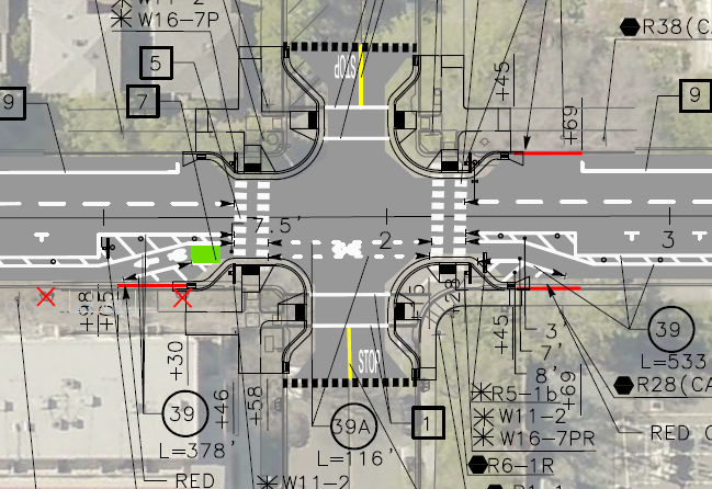
Turn Wedge
The project page has a diagram that I had not exactly seen anywhere before, the corner wedge, below.
Central City Mobility Project diagram turn wedge
I saw a location marked for a turn wedge yesterday, at 21st St and O Street, southwest corner, below. This is a little bit like a corner of a protected intersection.
Sac_21st-St-O-St-SW_turn-wedge
5th Street Two-Way Conversion
I looked at the length of 5th Street, from Broadway to I Street. I still have no insight into what will be done under Hwy 50 where there is a one-way block that is closely tied to the freeway onramps. I have requested clarification from the city but they have not answered yet. I’ll update when I hear.
Signal bases have been installed for new signals from W Street to N Street, but not north of there. Active work was going on at N Street. At R Street, it looks like the existing pedestrian flashing light will be duplicated for the other direction. This is not a full signal, nor a user-activated signal, but always on.
Between Broadway and X Street, 5th Street is two-way, four lanes, with sharrows marked (and very faded) in the outside lane. Sharrows are no longer considered valid bikeway markings, so presumably there will be marked bike lanes here. There are three very-wide blocks for 5th Street, from N Street to L Street, and from J Street to I Street. From N to L, there are two through lanes and one or two left-turn lanes, plus parking and bike lanes. From J to I, there are two through lanes and two left-turn lanes, plus parking left and right and a bike lane on the right.
On the west side of the intersection of 5th Street and I Street, there is a crossing prohibition. I hope that the city removes this prohibition as part of the project. In most cases, freeways onramps and off-ramps being an exception, crossing prohibitions are an attempt by the transportation agency to prioritize motor vehicle volume and speed over all other considerations. They are morally wrong, and should be legally wrong.
Sac_5th-St-N-St_extra-wide
I Street Separated Bikeway (and lane reduction)
Some work has started on the I Street separated bikeway, which will run from 21st Street to 12th Street (see the importance of I Street for why it should continue west). Most corner ramps were already ADA compliant, but the few that were not have either been upgraded or are in progress. Fabric covers have been set up over drain inlets, and temporary no parking signs line the street, so I assume repaving will occur soon. I don’t see any indication of whether the separated bikeway will be on the right side or left side of the street. I Street does not have SacRT fixed route bus service, which engenders left side bikeways, though there is some commuter bus service on the street.
The project map indicates that I Street will be “lane reduction and separated bikeway”, not parking protected separated bikeway, so this will be a different configuration than 19th Street and 21st Street.
I will be interested to see if the city will address the lack of sidewalk on the south side of I Street between 16th and 15th, where the city installed a loading dock for Memorial Auditorium in place of the former sidewalk. I strongly believe that removal of sidewalks, as was done here, are criminal (Sac permanently closes sidewalk).
19th Street Repaving
It looks at though 19th Street is not going to be completely repaved in the way 21st Street was, rather, it is getting spot repaving. I don’t know whether there will be an overlay so that the new marking are on a fresh blank canvas.
9th & 10th Street Parking Protected Separated Bikeway
The 10th street parking protected separated bikeway will be extended from Broadway to Q Street. The block of Q Street to P Street has a buffered bike lane, outboard of parking in the south half, and without parking in the north half, and since that block has recently been changed, it will likely stay that way. There is a buffered bike lane from Q Street to L Street, and then a parking protected separated bikeway of variable quality from L Street to I Street. There is no bus service on 10th Street, so the right side configuration will probably be maintained throughout.
10th Street is relatively wide under Hwy 50, so no special treatment here will be needed.
On 10th Street there are ADA ramp upgrades at several locations, and several more haven’t started yet. The street has a lower rate of ADA compliance than many central city streets. There is no indication of roadwork yet.
The 9th Street parking protected separated bikeway is being extended south from L Street to Q Street. There is no indication of any sort of work here yet. Most corners already have compliant ADA ramps. There is construction on the east side of 9th (right side southbound) between L Street and Capitol Mall, and on the west side (right side southbound) between N Street and O Street, and between P Street and Q Street. All of these construction projects will probably be going on for quite some time, and this may be the last street to be modified. SacRT Bus Route 51 runs on 9th Street south of Q Street to Broadway, which is outside this project scope, but presumably argues for keeping the left side bikeway configuration throughout.
More information on the curb extensions (bulb outs) being installed on the northeast and southeast corners of the intersection of 19th Street and O Street, as part of the Central City Mobility Project. I questioned this location for curb extensions because 19th Street with have a parking protected separated bikeways on the left side (southbound) of 19th Street. (Central City Mobility update)
I received a response from the engineering firm for the project:
This is in response to your inquiry as to compatibility of the subject intersection revisions and parking protected bike lane. The design does account for the bulb outs at the intersection. Unfortunately, due to the space restrictions resulting from the bulb outs, it won’t be possible to provide parking protected all the way around the bulb outs. However, we are providing a transition of the bike lane at the intersection. Please take a look at the following striping design for the intersection. North is to the right with 19th Street running left to right. Hopefully this will give you a better feel for the plan:
Any reader of this blog will know that I love curb extensions. What confuses me is why this location would have been selected by the city over many other potential locations. Perhaps some of the reason it that the crossing at O Street has a moderately high walker count, but does not otherwise have a traffic signal or pedestrian signaling such as a RRFB. It is possible that the city thought these four corner curb extensions to be the most practical way of increasing safety for walkers and bicyclists crossing at this point.
The design of bringing the separated bikeway out adjacent to the general purpose travel lane, as a bike lane, is not ideal but not particularly unsafe. In fact some bicyclists prefer this design, because it increases the visibility of bicyclists by motor vehicle drivers, so that they are not ‘hidden’ behind parked cars. Though daylighting of the intersection approach can accomplish the same objective.
I would like to see green skip paint continuing through the intersection in the bike lane. These are often painted as discontinuous green rectangles with sharrows stenciled on top, called green-backed sharrows. The sharrows are out of favor with most bicyclists and some traffic engineers, I think this is a valid use of them. The main purpose of green paint (it has no legal meaning) is to increase driver awareness of bicycle facilities by highlighting conflict points, and this is definitely a conflict point.
The repaving of 21st Street between W Street and I Street is complete. The section has been marked with ‘temporary road marker tabs’ (these have various names). The marking is for parking lanes on both sides, of eight to ten feet, and ultra-wide general purpose travel lanes, of at least 16 feet. No bike lanes were marked, though the street previously had marked bike lanes. A typical move on the part of the city and its contractors, to take care of motor vehicle travel and parking, but forget about bicyclists. This is of course temporary, but state and federal law require accommodation of bicyclists in construction zones. No such accommodations was made.
21st St between J St and I St, ultra-wide travel lanes, parking lanes, NO bike lanes
There are temporary paint markings for the first several blocks north of W Street, showing what the paint configuration will be. The parking protected separated bikeway is, as was likely, on the left side because most of this stretch has bus service on the right. The bike area is about seven feet wide. The buffer strip of about three feet wide, and the parking lane is about eight feet wide. The buffer may or may have vertical delineators (soft hit posts) continuously or at conflict points. There is no indication at any location, so far, that there will be hard curbs to actually protect bicyclists when parked cars are not present. For information on why a seven foot bikeway is not sufficient, please see bike lane widths. NACTO recommends at least eight feet.
21st St temporary marking for separated bikeway
As I rode up 21st Street, I noticed that the bus stop is marked in the same way that the parking lane is. I hope this is just a temporary mistake, otherwise there will be parking in the bus stop despite the red curb. The city is still failing to do two things it can to better support transit: 1) install concrete bus pads so that the weight of the bus at the stops does not distort the pavement and cause potholes, and 2) paint the pavement red at each bus stop so as to make it clear that this is a place for buses only, and not private vehicles. And, yes, it would be nice if transit islands were installed so that the bus does not need to pull out of and then into traffic. The city keeps saying that it supports transit, but doesn’t actual do anything to support transit.
21st St bus stop, marked as though it were a parking lane
Lastly, in the category of ‘be careful what you wish for’… I had wondered why the city was not taking advantage of the ADA ramp project to put in curb extensions (bulb-outs) at some critical intersections for walker safety. This afternoon, I noticed that they are putting in curb extensions on the northeast and southeast corner of 19th Street and O Street. Yay? Nay? The problem is that the location of the extensions would extend into the separated bikeway on the left side of 19th Street southbound. The photo below, looking north along 19th Street at O Street, shows the extension under construction. There is supposed to be a curb-adjacent, parking protected separated bikeway here. I assume that bus stops for SacRT Route 62 southbound will be on the right hand side of the street, and the separated bikeway on the left hand side. Is there anyone paying attention? Anyone? Ferris? Anyone?