Thanks for the website Mapping Inequality: Redlining in New Deal America, I have better copies of the Sacramento redlining map, which was produced in 1937 by the Federal Home Loan Bank Board and the Home Owners Loan Corporation (HOLC). These were government sanctioned zonings meant to guide banks to only loan to certain kinds of people in certain areas. Specifically, higher income white people.Though the official endorsement of the federal government eventually ended, the practice continued into the 1970s, and is with us still today. The best book on it is The Color of Law: A Forgotten History of How Our Government Segregated America by Richard Rothstein, which I highly recommend.
I had seen this map before, most likely from the posts of Bill Burg, but had not seen a high quality version, and had never found the GIS data. In 1937, Sacramento was a pretty small city, not going south past Land Park or north past Del Paso Heights, so the maps only cover a tiny part of what is today Sacramento. But as the city grew into other areas, the same practice redlining continued.
The first map below is the ArcGIS version, the second a scan of the original 1937 map.
Sacramento HOLC redlining map 1937 (click for pdf)original map, scanned (click for high resolution)
The 2017 video, Why We Cycle, was offered for free streaming for one day, yesterday. Though the freebie is over, I highly recommend you watch the video; at $4.99 it is still a great deal. This video has brought joy to me in ways that I haven’t felt in a while, and I think it will do the same for you.
So if you can push the car out of the city grid, leave it at the edges, and go walking further, it’s an enormous advantage for health, for clear air, for interaction.
Sjoerd Soeters
Though the bicycling infrastructure in the Netherlands has received the greatest notice in the US, this video is only secondarily about the infrastructure, instead focusing on cultural capital and transformation.
My own commute is cycling, that’s because I live cycling distance from work, but that is not a coincidence, that is why I live there.
Erik Verhoef
The video demonstrates the long list of benefits to a cycling culture (note that the video unapologetically uses the term cycling, without the cultural baggage of spandex and Strava and high priced bikes that the term carries in the US):
convenience: the bike is often the quickest way to get somewhere
economics: the bike is far less expensive than private motor vehicles, and even than transit
health: an active life brings measurable and significant benefits to the individual and to society in health care costs
cognitive: because bicycling requires people to be aware and interact with a large amount of information, there are clear benefits to cognitive development and maintenance
creativity: bicycling increase creativity, while on the bike and in life
reduced absenteeism: work absenteeism is lower for people who bicycle, and presumably for school as well
freedom to move: people are much freer to go where they want to go, when they want to go, on a bike
diversity: bicycling exposes people to diversity that they would not be if driving, to meet the ‘other’, to actively negotiate the flow with others
It’s the story of living in a city that is human scaled, that allows me to engage with the social/spatial environment… the intangible effects…
Marco te Brommelstroet
Data on bicycling trips clearly pointed to the conclusion that choices were often governed much more by the senses than the coldly logical plans of traffic designers, even causing people to leave the safe but sometimes boring cycle-ways for more interesting routes.
I noticed in the video, and it was commented on by one interviewee, that some signals have all ways for bicyclists at the same time, a bicycle scramble, so to speak. Because bicyclists have so much experience with negotiating with each other, it just works!
… it relates to the culture of mutual shared respect, but also the culture of trust; instead of infrastructure, by the users of infrastructure
Fariya Sharmeen
The adolescent social area can be the whole city, not a limited area close to the home. It’s about fun, being together. The video highlighted schools where nearly every student walks or bicycles, such a huge contrast to the US.
Dutch children are the happiest children in the world, just because they can go farther and farther from their homes…
Cycling is a good metaphor for a good education.
… to put the priority in relationships between people, then we support the cycling, we support freedom for children. Priorities for children and for bikes are good priorities for a happy politics.
Leo Bormans
A better world is possible, and we can achieve it if we work together and insist that each decision we makes moves us towards that end, and away from the car supremacy under which we have suffered, and died.
The last month has brought an awareness to many people about what essential is. I doubt if you asked people in January who the essential workers are, you would have gotten an answer that matched who turned out to be essential. I probably would have missed most of them. It is not the rich, or the techies, or the entertainers, or the politicians. It is the lower paid workers, the people who pick, harvest and prepare food, the people who staff grocery stores and pharmacies, teachers, and of course the medical profession. I am not in any of those categories, and the fact that I am not, and am still working and getting paid, means our society has been valuing the wrong people for the wrong reasons.
With our new understanding of essential, I am wondering how we apply this to driving. What is essential driving? Streetlight VMT Monitor indicates that driving in Sacramento County is down 66% (2020-04-14). What were those trips that were formerly being made? Well, some of them were commuting to work trips, but those would account for no more than 2 one-way trips per day, for some people. Nationally, commute trips are down below 25% of total trips. So that can’t explain a 66% decline, even if no one were going to work, which we know is not true. I suspect people who are doing what could be considered essential trips – to essential jobs, and to the grocery store and medical services – are about the same rate as before, so that doesn’t account for the decline either. The only conclusion I can come to is that a significant portion of those trips not now being made were non-essential.
I know that when I am out walking and bicycling for physical activity, I see a lot of people who are probably just driving for pleasure. Obviously those speeding egregiously, which is at least 20%, are driving for the pleasure of doing what they want on the mostly empty roads, other people be damned. And a lot of the other people do not seem to be heading towards or away from work, or the grocery store. A lot of people are just out driving around. If we eliminated these non-essential trips, I suspect VMT would be down at least 80%.
Even the grocery store is problematic. I see people coming out of grocery stores with a small purchase, an amount that could easily be carried on a bike, or even walking. Of course I don’t know how far these people are going, and what their specific situation is. It true that many, many people have chosen to live in places where the distance to a grocery store is not walkable or bikeable, the sprawling suburbs. Conversely, some people don’t have much choice about where they live, and end up in food deserts, because they can’t afford to live in places with grocery stores. And there are a few people whose only reasonable transportation mode is a car, due to physical disability, but those are very few in number. I am going to say that many trips to the grocery store also fall into the non-essential driving category. (Note: this was going on long before the pandemic, with Trader Joe’s being the poster child for people who drive to the store and leave with small amounts of groceries not requiring a multi-ton motorized vehicle to transport.)
Let me say up front that I have no data to back up what I’m going to say. But it does fit the data about VMT reduction, and what we know about travel modes, and what I observe on the street.
At least half the car trips formerly being made were non-essential. Probably much more.
So what? Well, we know, unless we are ideologically opposed to knowing, that motor vehicle travel is 40% of all carbon emissions in California, and it is the portion of our emissions that we have made no progress in reducing. So, every non-essential car trip is a crime against the climate, a crime against people’s health, a crime against livability of cities.
I am not sure how to best eliminate all these non-essential trips. Pricing fuel, or travel, or parking, is part of the solution. This is often called congestion pricing, but the point is not to reduce congestion but to eliminate unnecessary travel. We need to stop subsidizing non-essential travel, we need to make it hard for people to make this choice. Obviously the controls cannot be primarily economic, as that would hurt the people the most, who have the least choice. But it must be in part economic, because middle and upper income people make choices based on money.
Some suggestions:
Convert areas of the city that are and look urban (downtown, primarily, but other areas as well) into superblock areas, a la Barcelona, where many of the streets become car-free or car-light. This is easiest to do where there is a grid street network, harder but not impossible to do other places.
Reduce street parking significantly, starting with streets where the right-of-way is needed for other purposes, such as sidewalks, sidewalk buffers, and bicycle facilities. I am not against street parking, as it does serve somewhat to slow traffic, but where the space has a higher use, it should be eliminated and reallocated. At the same time, we should never build another structured parking deck (parking garage). These structures NEVER pay for themselves in parking revenue, and so they are a subsidy from everyone to drivers (whether they are public or private, makes no difference, they are an inefficient use of capital). I would suggest we eliminate 10% of all parking in the central city, within one year, and then evaluate the impact on non-essential travel. If it has not decreased significantly, then eliminate another 10%, and on until non-essential travel becomes rare.
Charge the real cost of parking, on street and decks. The city only charges enough, roughly, to cover the cost of the program, meaning enforcement and administration. The land used by parking comes free, as a subsidy to those parking. The cost of repaving the parking lane (which we should not be doing anyway) comes free, another subsidy. The difficulty the city has in converting parking space to other uses, such as bike corrals, parklets, delivery zones, and drop-off/pick-up areas, which are often higher uses than parking, is another give-away to drivers, and residents and businesses who think they own the parking spaces.
Shift transportation expenditures away from private vehicle transportation, in favor of necessary freight, transit, walking and bicycling. That means #NoNewRoads and #NoNewLaneMiles. We maintain what we have but we don’t build any more. We stop paving parking lanes to the same standards as streets, and let them deteriorate. And we let low-traffic streets that serve very few people (cul-de-sacs, primarily, though some semi-rural roads, as well) go back to a natural surface, unless the users of that street want to pay the full, unsubsidized, cost of paving.
There are a lot of reforms that must happen at the state and federal level, and I’m not addressing those here. These are ideas that can be implemented locally, at the city and county level.
I have long been interested in access to parks, what the availability of parks is to people, and wanted to map this. It is just today that I was finally able to start doing this. I acknowledge the support of the Sacramento Area Council of Governments (SACOG) GIS staff, without which I could not have done this, as my ArcGIS skills are limited, though growing, and my access to the needed data is also limited.
This issue of access to parks, always important, is suddenly critical under the pandemic, with people needing places to walk where they can achieve physical activity with appropriate physical distancing. With many neighborhoods in Sacramento not having sidewalks, or having narrow sidewalks (six feet at best, often five feet, sometimes four feet or three feet; yes, three feet!), and some of those who are still driving doing so very recklessly, sidewalks in and of themselves don’t make it for large areas of Sacramento.
Advocates all over the US, and the world for that matter, have asked that cities and counties open up streets for walking and bicycling, sometimes by prohibiting drivers and their motor vehicles, sometime allowing only local access. In the US, Oakland has become the leader in this (Oakland Slow Streets), though many other cities have implemented programs as well. The City of Sacramento is also considering this, with staff working on a proposal, though it is not known yet what it will look like, or if it will be adopted. A number of people have made suggestions for streets to ‘close’ (meaning open to walkers and bicyclists), but the nature of advocacy is that many of these suggestions have been for areas that have sidewalks, and that have parks, because these are the areas where many advocates live. I’m not saying they are wrong, but I want to do my part to see that open streets occur in the areas that most need them, which is almost always the low-income, disinvested areas of north Sacramento/Del Paso Heights and south Sacramento.
So, I picked two zip codes to map. One is 95814, the central city downtown, and the other is 95824, an area of south Sacramento (which includes both City of Sacramento and unincorporated Sacramento County).
The maps shows the park locations (from the SACOG Regional Parks & Open Spaces 2018 data), and the 10-minute walking area around these parks. The reason I picked 10 minutes is the initiative by the National Parks and Recreation Association (NPRA) and partners: “We’re inspiring and enabling action to create a world in which 100% of people in U.S. cities—LARGE AND SMALL—have safe access to a quality park or green space within a 10-minute walk of home by 2050.” I’ve also included the Median Household Income for census tracts (ACS Median Household Income S1903 2013-2017). On the 95824 map, you can see that the entire zip code is less than 80% of California MHI ($67,169), a disadvantaged community. On the 95814 map, the 10-minute walking area covers up the MHI, but nearly the entire area is also below 80%.
Please note that there are many ways of mapping park access. In this case, I used park centroids (the geographic center of the park), which makes sense for smaller parks, but doesn’t work as well for large parks, and parks which are contiguous but named differently. There are also many ways of looking at disadvantaged community status, and at demographic characteristics. I chose ones that I had worked with before, and other criteria would yield different results. I’ve used zip codes here, though I think that if the cities and county actually analyze the data for need, census tracts are the better polygon size. Census tracts are less familiar to people than zip codes, but census tracts often more accurately represent what people think of as their neighborhood.
So, now with the maps. The first is 95814, downtown Sacramento, and the second 95824, south Sacramento. Clicking on the graphic map will bring up the option to download a pdf.
98814 zip code95824 zip code
As you can see, the entire 95814 zip code has access to a park within a 10-minute walk. The 95824 zip code, however, only about half the area has access. Very different places! Therefore, I would recommend that the 95824 zip code, for example, needs open streets, now, and the 95814 zip code does not.
I welcome your feedback on these maps. What would you like to see? What data should I be considering? Do you see issues of access and space for social distancing in this way, or another way? What areas do you want to know about?
sorry, could not find a photo for Sacramento,, but if someone provides it, I will replace this one of Los Angeles (via Business Insider)
We can’t go back to the way things were before! To the car-dominated world where walkers and bicyclists were considered second-class citizens, worthy of consideration only when it did not inconvenience the privileged drivers of cars. The streets are largely empty (except for some essential drivers and too many joy-riders). The air is clean. The city is quiet. It is (other than the above-mentioned joy riders) safe to cross the street, to bicycle on the street, even in some places, to walk in the street. I don’t intend to ever go back, and will work to make sure we do not go back.
Here is a list, with brief notes, of areas in which I think we should not and cannot go back. No priority order. I think that over time my ideas can be refined and added to. Let me acknowledge the many people on Twitter, my main social platform, for giving me a lot of good ideas and food for thought.
Right to Move: I believe that, as humans, we have a right to move, to freedom of movement (though I also believe that reduction or even suspension of this right for public health during a pandemic is acceptable, though traumatic). However, this right is expressed through walking (or mobility devices for those not able to walk). It is not expressed through bicycles, or scooters, or even transit, and it is absolutely not expressed through privately owned vehicles. I am not saying that bicycles and scooters and transit are not good methods of movement for transportation, but walking must always be the most important and the most guaranteed, our most basic right, with other modes coming later, if at all (in the case of cars). I am tired of myself and others being terrorized by private vehicle drivers, who are all too happy to inflict their traffic violence on innocent people. Walking FIRST!
Transportation
all pedestrian signals should be set on recall; they should be labeled with their function; and if there a locations where traffic engineers claim such a low rate of pedestrian use, I’d ask for an analysis of why is there no pedestrian use; if it is an urbanized area, why aren’t there pedestrians, and if it is a rural area, why is there a signal?
failure to yield to pedestrians (CA CVC 21950) should be considered a sociopathic offense, similar to drunk driving and smoking in buildings, and strictly enforced; I am not just concerned about the number of pedestrians who are killed and severely injured by drivers, but about all the people who could walk, but don’t, because they are rightfully afraid of car drivers; drivers who repeatedly violate this should have their driving privileges revoked (drivers license suspended and vehicle impounded), and those who still violate should be jailed
#NoNewLaneMiles (a more specific version of #NoNewRoads); we have all the roads we will ever need, we just need to use them more efficiently by increasing the density of homes, jobs, and services; because there are no new roads, there will be no greenfield developments, as we have plenty of infill/redevelopment land to work with, and we have an excess of single family homes
expenditures on roadways will only go to maintenance, and once a level of good repair is achieved, then to true complete streets projects which reallocate roadway space and increase safe crossings
all roadways that are more than two lanes per direction must be reduced to no more than two lanes. Drivers have proven themselves, again and again, incapable of responsibly using wide roadways, and so these wide roadways must end. Temporarily, we can put up barricades or delineators to reduce the lanes, and in the long run, determine and then implement ways of re-allocating this space to best serve the community; some land might be available for housing development
freeways will be designed and sized for freight movement, not for commuting; interstate commerce is the primary legally and morally justifiable use for our Interstate system; the idea of continuously expanding freeways so that a continuously expanding number of people can choose to commute continuously expanding distances is not socially or economically rational or feasible; where there are more than two lanes on a freeway, one or more of them should be designated (and enforced) as a freight-only lane so that freight is not slowed by commuting traffic
private and commercial fossil-fueled vehicles must be strictly controlled on all spare-the-air days; if the air quality particulates (winter) or ozone (summer) exceeds the ‘healthy’ level, then we start shutting down vehicles; this would be much easier to do if we implemented a pricing scheme (congestion management) all the time, but if we are still working on that, we can in the meanwhile reduce traffic; I’m thinking the easiest way to do that is to control on-ramps and off-ramps, since most long distance commuters, and much commercial traffic, is using the freeways; some on-ramps already meter vehicles, and we could just slow this down so fewer vehicles are allowed to enter; we would have to add off-ramp metering; there are a lot of ways of managing traffic, some of the best controlling the amount of underpriced or free parking, but this is definitely one to explore
vehicles must be speed limited, so that drivers cannot exceed safe speed limits; this is one of the easiest to accomplish because all modern vehicles could be speed limited with minor software modification, but I realize that it is politically the least feasible; nevertheless, we need to be talking about it and advocating for it
Work from home: I fully understand that not every job is amenable to working from home, and interestingly, it turns out that almost all of the truly essential jobs are not, but nevertheless, many jobs are; employers should be required to analyze each job position to determine whether a particular job could be done from home, either all the time, or some days of the week, and then to implement work from home policies that allow the least in-person work required
Schools: I am part of the educational system. I like the idea of school choice, and I think it has a number of benefits. However, I also see the cost of it. A huge amount of driving, taking students to and from school. The idling of cars outside the school has a measurable and negative impact on air quality in the classrooms. Much of this driving is unnecessary, and trips could be done walking or bicyclist, but is driven for the convenience of the parents (not the students). The greatest danger students walking and bicycling face is the drivers taking their own child to school, and in addition to the direct danger, there is the intimidation that makes people less willing to walk and bike. Students are getting significantly less physical activity. Students and families feel less connected to the neighborhood they live in, and the school feels less connected to its neighborhood as well. So:
for any school located on an arterial with more than two lanes of traffic in a direction, lanes will be immediately closed in order to increase the safety of students walking and bicycling, and to create a less polluted and hectic environment
private vehicles will be prohibited on campuses, except where the parent has submitted a statement to the school detailing why a particular student must be transported directly to the school (meaning, a disability of some sort), and received a pass; schools are there to educate students, not to accommodate drivers
for schools located on local streets, the block on which the school is located will be closed to through traffic for the duration of arrival and dismissal (or longer); of course this means that students and families using mobility devices must be guaranteed high quality sidewalks and crosswalks, with ADA ramps, at least 6 feet in width, and in good repair
school districts should have a conversation with families and the public about the ways in which a non-neighborhood school supports and does not support academic learning and the needs of its community
Housing: Part of the reason we have a housing crisis is that single family homeowners have been able to suppress the building of homes, for some types of people (read: minorities) and for some kinds of housing (read: multi-family), for a long period of our history. We all suffer from this: un-housed people, high rents, separation of jobs and housing, climate change, air pollution, most of our transportation dollars going to long distance commuters while we have potholes in our local streets, underinvestment in transit and rail, etc. The most egregious, though largely hidden from view, aspect of this is that single family housing has bankrupted our cities, and counties, and state. Single family housing can never generate enough sales tax or property tax or user fees to pay for the maintenance required to sustain all these spread out houses and roads and utilities and law enforcement, and fire, and, and and. I think it is becoming clearer by the day how financially on edge our governments were. They have huge bond debt, huge deferred maintenance and well as current maintenance obligations, and far too much reliance on new development just to keep the old going (which is called the development ponzi scheme – see Strong Towns). Sprawl is the primary though not the only driver (pun intended) of this. So:
immediately remove all residential zoning classifications, so that there is only one residential zone, and no limit on the types of housing that can be constructed on a piece of land; until such time as we can analyze what we need in terms of zoning and development standards, I’d leave the rest be, but this is a step we can and should take immediately
no developments (even infill) larger than a certain size should be allowed to deed road and utility improvements to cities and counties, unless they pay a fee to a maintenance endowment sufficient to maintain that infrastructure for all time; I am not talking about development fees, which of course are used to maintain past infrastructure and to keep the doors open, but never retained for the future, rather, these are banked funds to meet the needs of the future
recognize a right to housing for all people; this is obviously a huge undertaking, for which governments may not have the money (because of the sprawl subsidy and bankruptcy detailed above), though there is certainly a lot of shifting of resources that could get us a significant way there, but we need to start working toward that goal now, and with much of our societal focus on how to solve the issue as quickly and equitably as possible
Thank you if you stuck with this long list to the end. As I said, it is preliminary, and your constructive comments here or on Twitter are welcomed.
I admit that I thought we had a decent world, many issues to work on, but sort of OK. Probably some others felt this way. But the bottom has dropped out, for those in poor health (much of that poor health due to all the actions above that we did not take), people of color, low income people, un-housed people, people dependent on employer-provided health insurance, people in essential jobs. I am very lucky! (yes, the luck of privilege).
I hope that we reflect deeply on the clean air and streets available for people (outside cars) to live, and all join together to make sure we do not go back to the old, unenlightened times, but to work hard towards a better future.
I am quite aware that I have not mentioned, or have lightly touched on, a lot of other issues that are critical to so many people. Climate change is one of the biggies for me. Please don’t think that those other issues are unimportant to me, but transportation is my expertise and advocacy, and it needs strong voices, now and always.
Maps have suddenly become the preferred method for presenting information, which is a good thing. But I see so many maps that don’t present what they are claiming to present, or supporting the story being told in the text. Ack!
Since coronavirus maps are the rage, I’ve selected two to show. These are from the UCSF Health Atlas, which just added COVID-19 data by county. Take a look for yourself, a fascinating website, that I was not aware of until today. The first map is of COVID-19 cases. It shows Los Angeles county as having the most, followed by San Diego county and then Santa Clara county. The second map is of COVID-19 cases per 100,000 people. It shows Mono county as having the highest rate, followed by San Mateo county.
COVID-19 cases, source UCSF Health AtlasCOVID-19 map, cases per 100,000 people
Remarkably different maps, eh! Why?
Numbers don’t tell a story of any use to responding to the pandemic, or of any other planning effort. The important quantity is rate, and in this case the rate is per 100,000 people. The table below shows a selection of counties and their statistics. If one looked at just the numbers, Los Angeles county would look like a horrible place to be. Yet the rate is below a number of other counties in California. Los Angeles county contains over one-quarter of the people in California. In fact, Mono county is the worst place to be right now, with a rate far above any place else in the state.
County
CV number
CV rate
density
population
Los Angeles
5955
59
5076
10,098,052
San Diego
1326
40
2728
3,302,833
Santa Clara
1207
63
3186
1,922,200
San Francisco
568
66
11,413
870,044
Mono
19
135
17
14,174
Inyo
11
60
126
18,085
San Mateo
555
73
3237
765,935
Marin
141
54
2294
260,295
selected county statistics
The second major issue that number maps lie about is the importance of density. It is currently popular, especially among NIMBYs (not in my backyard), but even some in the medical profession, to claim that density is a problem, that density has fueled spread of the virus. And that once the pandemic is over, the prominence of cities will be over, that everyone will realize that the suburbs were the best and safest place all along, and go back to their long distance commutes. Bullshit! If density were the problem, San Francisco city/county would have the highest rate, but its rate is fairly average for California. And largely rural counties like Mono would have very low rates, but its rate is the highest. Before you ask, no, I don’t have similar data for New York, nor I am sure what it would show.
All of this comes with the standard disclaimer that COVID-19 cases are dependent upon testing, but testing has been widely variable in different counties. I have not seen any statistics on testing at the county level, but that is another data set that could be used to normalize cases in the similar way that population is used to normalize cases. And as the pandemic progresses and the curve declines (someday), the data may look very different. But in the meanwhile, the best we have and the best we can do for planning is to use rates.
So how does this relate to transportation, the topic of this blog? Transportation agencies, both road builders and so-called safety agencies (OTS and NHTSA) almost always report numbers and not rates, and make claims about what is important based on those numbers. They are reluctant to report rates, or anything, though if you read to the end of their reports, or search in their data tables, the rates are usually there, just not obvious. They agencies are also very reluctant to compile pedestrian counts or bicyclist counts, claiming it is too expensive, but really what they are saying is that pedestrians and bicyclists are not important enough to count. They wouldn’t like the statistics that result from data normalized by trips numbers or trip length for pedestrians and bicyclists, because such data would probably force them to select different projects and have different priorities than the ones they have.
The Health Atlas also has data on Street Connectivity, which I hope to explore since it relates so strongly with walkability and bikeability.
The Manual for Uniform Traffic Control Devices (MUTCD), and the California equivalent, are standards for the design and placement of traffic control signs. They have the force of law for any federal or state funded roadways, but there is no enforcement mechanism, so signs that do not meet these standards can certainly be found, both in places that just decide they know better, and in places where the public right-of-way and use is evolving rapidly and the glacial pace approval of new signs is not keeping up.
The MUTCD has 14 signs related to the use of beg buttons to cross the street, in the R10-1 through R10-4 series. One of these is shown below, the most complicated one, R10-3e. Of the 14, none offer any information about whether the beg button is required or not. This is not an oversight; it is a direct expression of traffic engineer’s disdain for pedestrians. California could, of course, add other signs with better information, after approval by FHWA, but it has not seen fit to do so.
Noting the lack of good signs that actually address real-world situations, some entities have designed their own. One example is below, which came via Don Kostelec, of whom I’ll have more to say shortly. (original source not known)
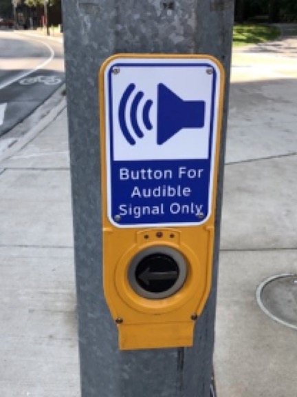
Why is the distinction between these two types of signs important? Buttons can be used by limited vision or blind people to trigger the pedestrian signal, and the auditory and sometimes vibratory message that goes with it. When the conversation started about removing beg buttons, many disability advocates were up in arms, understandably. If there is no button, there is no message.
Except, of course, for automatic detection of pedestrians, and even pedestrians types, that many other countries and a very few places in the US are installing. Traffic engineers routinely resist automatic detection as “too expensive and not practical” despite spending much larger sums on vehicle detection. Which in the case of bicyclists, often doesn’t work anyway.
Traffic engineers also frequently place buttons in places where people with disabilities, as well as everyone, can’t find them and/or can’t reach them.
So, is there a way to preserve the function of buttons needed by disabled people, while not discriminating against all pedestrians? You bet. Just label the button for its function. And put it in an accessible location.
So, Don Kostelec. He is one of my heroes, as he has done a better job than anyone I know of documenting the failures of transportation agencies to install safe and usable pedestrian facilities. Sidewalks too narrow, or that end where you really need them; ADA ramps to nowhere; crosswalks that can’t be safely used; and on and on. I highly encourage you to check out his blog (http://www.kostelecplanning.com/blog/) and Twitter feed (@KostelecPlan). He does not hesitate to call out road and traffic engineers for their failure to think, and for their failure to follow their professional code of ethics. Though he didn’t originate it, I think he is responsible for popularizing the expression “Hold my beer!” in the transportation world, implying that only an engineer drinking beer, and momentarily designing a roadway or facility before going back to drinking, could have done something that stupid.
There has also been a lot of discussion about whether it is hard to change the buttons from required to not required, which is called auto recall, or just recall. A number of cities have changed hundreds of buttons in very short order because they prioritized it. Newer signal control boxes allow changes to be made remotely, changing the function and timing of pedestrian signals. Older control boxes may require that someone go out and physically change them. The older boxes are sometimes derisively called squirrel cages because they had large physical clocks with rotating dial, with pegs to change the signal on or off, as it came around. They made noises like a squirrel or hamster cage. A few idiots have been saying that pedestrian signals should not be changed remotely because of security issues. That is the whole point of modern signal controllers, part of Integrated Traffic Systems (ITS), that they can be can sense and respond to actual traffic, and can be adjusted remotely to respond to changing conditions and for changing flow when crashes occur.
There is also the issue that many transportation agencies don’t know what is at the intersection. Does it have pedestrian signals or not? Does it have pedestrian countdown or not? What is the timing of the pedestrian phase, in terms of countdown? Is the beg button required or not? They simply don’t know. Locally, Sacramento County is the worst on this issue.
Now, on to why I brought up the topic of prudent drivers. A prudent driver on a two lane (one lane in each direction) roadway largely controls the behavior of irresponsible drivers. On wider roads, with two lanes or more in a direction, whether a one-way or two-way, the irresponsible driver can do as they wish, violating laws and endangering others. On the narrower roadway, the irresponsible drivers get irritated, and honk and cuss, but there isn’t much they can do about it. This difference in large part explains why fatality and severe injury crashes are rare on residential streets within neighborhoods, and are common on arterial streets with multiple lanes. It also explains why rural roads have such high crash rates, because the prudent driver there can’t really control other drivers. On two lane streets, prudent drivers set the tone; on multiple lane streets, irresponsible drivers set the tone.
We have proven, over the history of motor vehicle use in the US, that is is not possible to significantly change the behavior of drivers. Education doesn’t do it, enforcement (even when that used to be more common) doesn’t do it. Nearly all of the improvement in roadway deaths has been due to safer cars, not to safer drivers or safer roads, and now that improvement is reversing itself as more and more walkers and bicyclists are killed by irresponsible drivers.
I am not against education, if it is directed at the most dangerous behaviors, which it is not, and I am not against enforcement, if it is done in an unbiased manner, which it is not. Each state has an agency, usually called the Office of Traffic Safety (OTS), whose mission is to obscure the real causes of crashes and to blame walkers and bicyclist for their death and injury, and at the federal level, the National Highway Traffic Safety Administration (NHTSA) fulfills this function admirably. In this, they are often aided and abetted by the law enforcement agencies. The reason CHP is California is so opposed to automatic speed enforcement is because it would remove the mis-focus and bias that they otherwise rely upon.
Driver behavior must be controlled by roadway design. That is why I strongly believe that all multiple lane roads must be reduced. Two lane one-way streets must be converted to two-ways streets with only one lane in each direction (and any other lanes converted to pedestrian, bicyclist or transit use). Two-way roadways with two or more lanes in the same direction must be reallocated to other uses. Again, excess capacity would be converted to pedestrian, bicyclist, or transit use, or even to development as overly wide streets shrink to fit the real need.
I have no illusions about the huge change in traffic flow. Those drivers who have gotten used to having plenty of space for themselves (their cars) would have to figure out how to use less: fewer trips, shorter trips, slower trips. People would make different decisions about where they live, where they work, where they shop and recreate. As far as I am concerned, this is all to the good.
Our freeways are designed by the ‘best and brightest’ engineers to be as safe as possible, allowing errant vehicles extra space, protecting hard objects with guard rails and impact attenuators (crash barriers), and using ridiculously wide travel lanes, yet still have very high crash rates. Spending more money apparently doesn’t make freeways safer, and the explanation for this is risk compensation, the proven effect that irresponsible drivers will increase their unsafe behavior to maintain the same level of risk. Think about the daily news items about crashes that close freeways for significant periods of time, and how often they happen. None of these need to happen, and I’d argue that an irresponsible drivers is the primary cause of each and every one of them. This post is about local streets, not freeways, but it is worth remembering that irresponsible drivers are everywhere.
I don’t believe that one single death or severe injury for a walker or bicyclist is worth any amount of convenience for motor vehicle drivers. Not one.
So, I ask every transportation agency in the Sacramento region to:
cease widening roads, forever
analyze all one-way roads with three or more lanes to determine the most dangerous ones, and convert these within two years
analyze all two-way streets with more than one lane per direction for the most dangerous ones, and convert these within five years
analyze the remaining roads that are not one lane per direction, for the most dangerous ones, and convert these within ten years
complete conversion of all roads within twenty years
The previous post was about prudent drivers. The table below shows how I think of prudent drivers, and irresponsible drivers. It is so hard to not be snarky about driver behavior, but I have toned it down quite a bit. If you think I am exaggerating, then you don’t spend much time on the roads walking and bicycling. I spend a lot of time doing both, probably averaging three hours per day, all of it closely observing driver behavior and the roadway built environment, because it is both my job and my advocacy. The irresponsible behavior is something I see every day, from a significant percentage of drivers. Notice that I did not use the term negligent driver, as is the legal term in my prior post on a prudent driver, because only some of this is negligent; much of it is just sociopathic.
Prudent Driver
Irresponsible Driver
yields to pedestrians in crosswalks and waiting to cross
never yields to pedestrians
takes turn at stop sign intersections
goes out of turn at stop sign intersections
obeys speed limits, within 5 mph
drives as fast as possible in all situations
on multi-lane roads, always slows or stops if a vehicle in another lane is stopped
on multi-lane roads, pulls around other vehicles that are stopped, honks, and proceeds at full speed
rarely uses their car horn, and only to prevent a crash
often uses their car horn to make those other idiots pay attention and get out of the way
is aware of what is going on around them
is focused on other things than the road
doesn’t use their smart phone while driving, other than wayfinding
holds ongoing conversation on smart phone; texts when they think they can get away with it
passes bicyclists with a safe distance, even when it means waiting
yells at, honks at, and close-passes bicyclists, because they don’t belong on the road
believes all people have a right to share the public space on the roadway
believes that right to the roadway is determined by the value of their vehicle and social status
will do anything to avoid a crash
revels in crashes when they know they are right
knows the the cost of building and maintaining roads is subsidized by everyone
is certain that gas tax monies are being illegally diverted to other uses
knows that parking is never ‘free’ and someone, or all of us, are paying
believes that the right to free parking is guaranteed in the constitution, and that the parking space in front of their house belongs to them
700. Basic Standard of Care: A person must use reasonable care in driving a vehicle. Drivers must keep a lookout for pedestrians, obstacles, and other vehicles. They must also control the speed and movement of their vehicles. The failure to use reasonable care in driving a vehicle is negligence.
Judicial Council of California Civil Jury Instructions, 2019
The term ‘prudent driver’ does not exist in law or case law for California, though it does for some other states. The concept is useful enough that I’d like to explore it here. The term is closely related to other concepts such as a ‘reasonable person’, ‘prudent man‘, ‘prudent person’, ‘duty of care’, and ‘standard of care’. The Judicial Council of California Civil Jury Instructions (CACI) document, excerpted above, is often referred to a ‘case law’, instructions for how to interpret legal codes, based on court findings. Many terms in California Vehicle Code are left intentionally fuzzy, but case law removes much of, but not all of, this fuzziness. In civil law, which is what this document covers, the three criteria for establishing liability are negligence, causation, and harm, meaning that the person acted in a negligent way, and harm was caused by the negligence.
Of the two issues most relevant to people walking, speeding and failure to yield are the most significant.
706. Basic Speed Law (Veh. Code, § 22350): A person must drive at a reasonable speed. Whether a particular speed is reasonable depends on the circumstances such as traffic, weather, visibility, and road conditions. Drivers must not drive so fast that they create a danger to people or property.
Judicial Council of California Civil Jury Instructions, 2019
Section 706: Basic Speed Law (and sections 707 and 708), presents the idea that violation of the speed limit is not, per se, evidence of negligence on the part of the driver, but that the test is whether the speed was reasonable. In most European countries, violation of speed limits is negligence, but unfortunately that is not the case in the US. But the document does lay out pretty clearly that the driver is responsible for controlling their vehicle and anticipating the presence of other users on the roadway.
710. Duties of Care for Pedestrians and Drivers in Crosswalk (Veh. Code, § 21950): A driver of a vehicle must yield the right-of-way to a pedestrian who is crossing the roadway within any marked crosswalk or within any unmarked crosswalk at an intersection. When approaching a pedestrian who is within any marked or unmarked crosswalk, a driver must use reasonable care and must reduce his or her speed or take any other action necessary to ensure the safety of the pedestrian.
A pedestrian must also use reasonable care for his or her own safety. A pedestrian may not suddenly leave a curb or other place of safety and walk or run into the path of a vehicle that is so close as to constitute an immediate hazard. A pedestrian also must not unnecessarily stop or delay traffic while in a marked or unmarked crosswalk.
The failure of a pedestrian to exercise reasonable care does not relieve a driver of a vehicle from the duty of exercising reasonable care for the safety of any pedestrian within any marked crosswalk or within any unmarked crosswalk at an intersection.
Judicial Council of California Civil Jury Instructions, 2019
Section 710 covers the failure to yield to pedestrians violation, CVC 21950. The case law does have some interesting quotes:
“While it is the duty of both the driver of a motor vehicle and a pedestrian, using a public roadway, to exercise ordinary care, that duty does not require necessarily the same amount of caution from each. The driver of a motor vehicle, when ordinarily careful, will be alertly conscious of the fact that he is in charge of a machine capable of projecting into serious consequences any negligence of his own. […]”
“It is undisputed that defendant did not yield the right of way to plaintiff. Such failure constitutes a violation of the statute and negligence as a matter of law in the absence of reasonable explanation for defendant’s conduct.”
To summarize, my interpretation of the judicial guidance is:
Drivers must control the speed of their vehicle, no matter what the posted speed limit, in recognition that they must always be aware of other users of the roadway and take all reasonable precautions to ensure that crashes do not occur.
Drivers must yield to pedestrians who are exercising reasonable care in crossing the street, and the pedestrian has a presumption of right-of-way in the absence of other evidence.
So, a prudent driver would not be negligent, and a negligent driver would not be prudent.
Next post, more about how a prudent driver behaves.