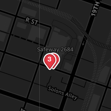
The JUMP website has a map view (https://jumpbikes.com/cities/sacramento/, scroll down) that aggregates bikes out-of-hub into a numbered icon, as below at left. The app (at least the iOS app) does not aggregate bikes, as below at right. That makes it harder to tell how many bikes are nearby to a location. These are the same three bikes, very zoomed in.
If bikes are parked right next to each other, and the GPS units have the same location, the additional bikes may not show up at all. I think that if the app opened to an initial view that aggregates the bikes, then you could zoom in to see individual bikes, it would be more useful. The bikes are not always right next to each other, sometimes they are spread out over a block, and you want that information, but I think the first piece of information you want is how many bikes at that location. Of course, what ‘right next to each other’ means depends on the zoom level.
The hubs apparently show in identical ways between the app and the web.