SacATC April 18 notes

These are my notes from the April 18 meeting of the Sacramento Active Transportation Commission (SacATC). The official minutes are not available until the agenda for the next meeting is released, about three days before the meeting.

City staff announced that due to hiring a consultant and the project timeline, the updated Vision Zero Action Plan would not be available until sometime in 2025, not this year.

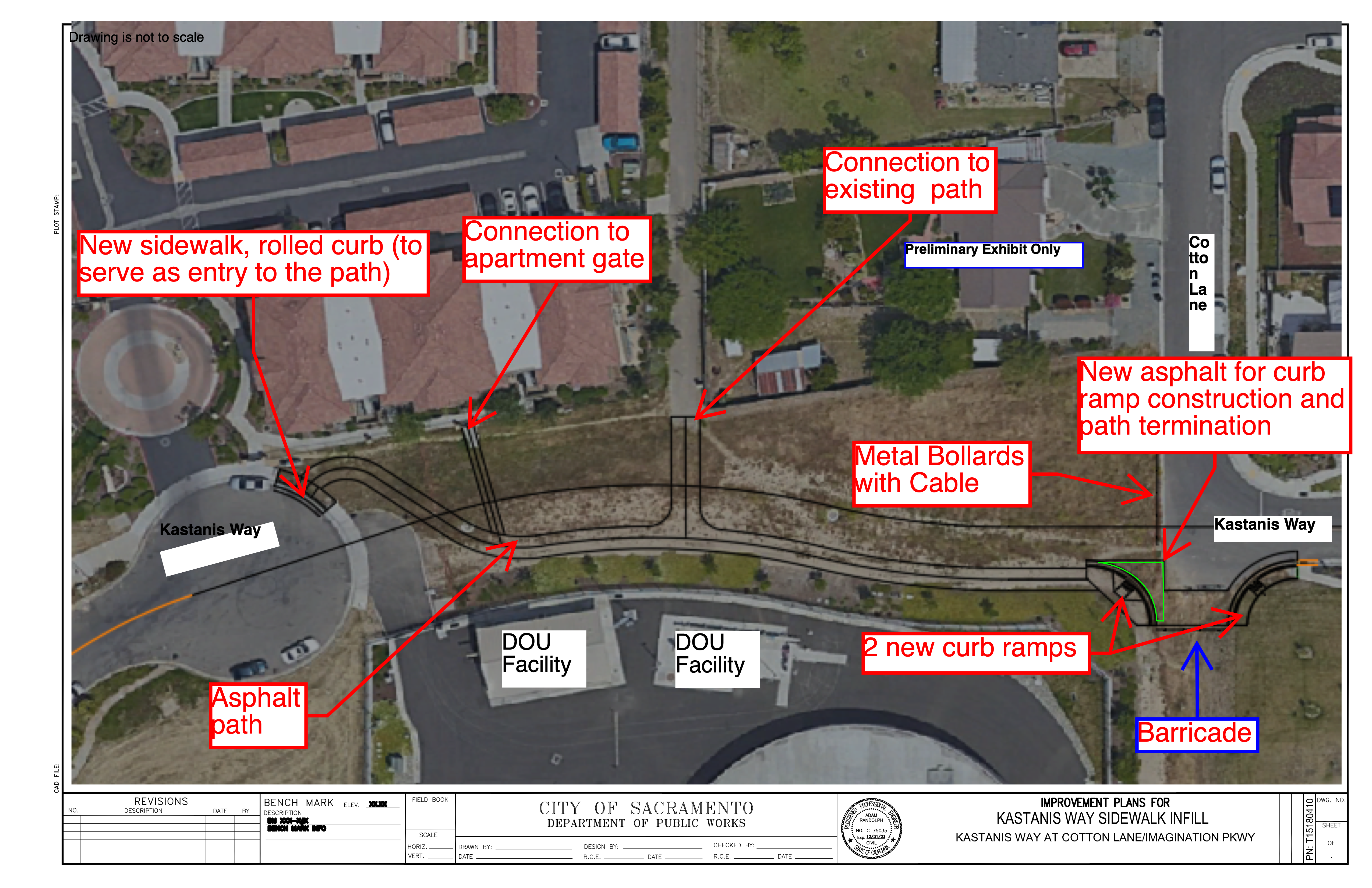
Agenda 4: Kastanis Shared Use Path. This is a wonderful project, connecting two ends of a dead-end street for walkers and bicyclists. It received my support and the full commission. Commissioners asked about lighting and trees, but as a sidewalk infill project from a very limited program, those could not be included.

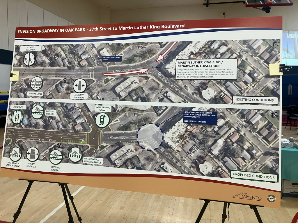
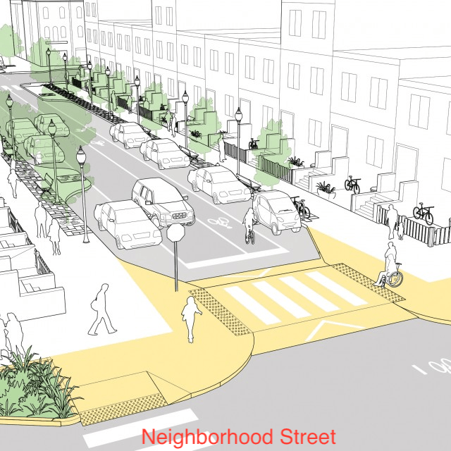
Agenda 5: Grand Avenue Sidewalk Infill. Another wonderful project, adding sidewalks on Grand Aveue adjacent to the Sacramento Northern Trail for better neighborhood access included ADA ramps on all corners. A SacRT bus stop location will also be improved. Again, my support and the full commission. Commissioner Harris, who represents District 2, spoke about the lack of sidewalks throughout much of the district, and the benefit of any infill projects.

I spoke on items ‘not on the agenda’, asking that the slide presentations be made available before the commission meeting whenever possible. There is often information in the presentations not available in the staff report, which can make a project look better, or worse. I also suggested that the commission ask for a presentation on how the city views its responsibility for bus stops, since this came up many times in discussion of the Grand Avenue project.

I hope that more people will attend the SacATC meetings and comment on projects (on online via eComment). This is the only real chance for public input on projects, other than going to your council member. Most Public Works projects are a black box without public input, so when there is the chance, it is time to speak up for safer and innovative solutions.

And now on to the more complex project, which took up the majority of the meeting time.

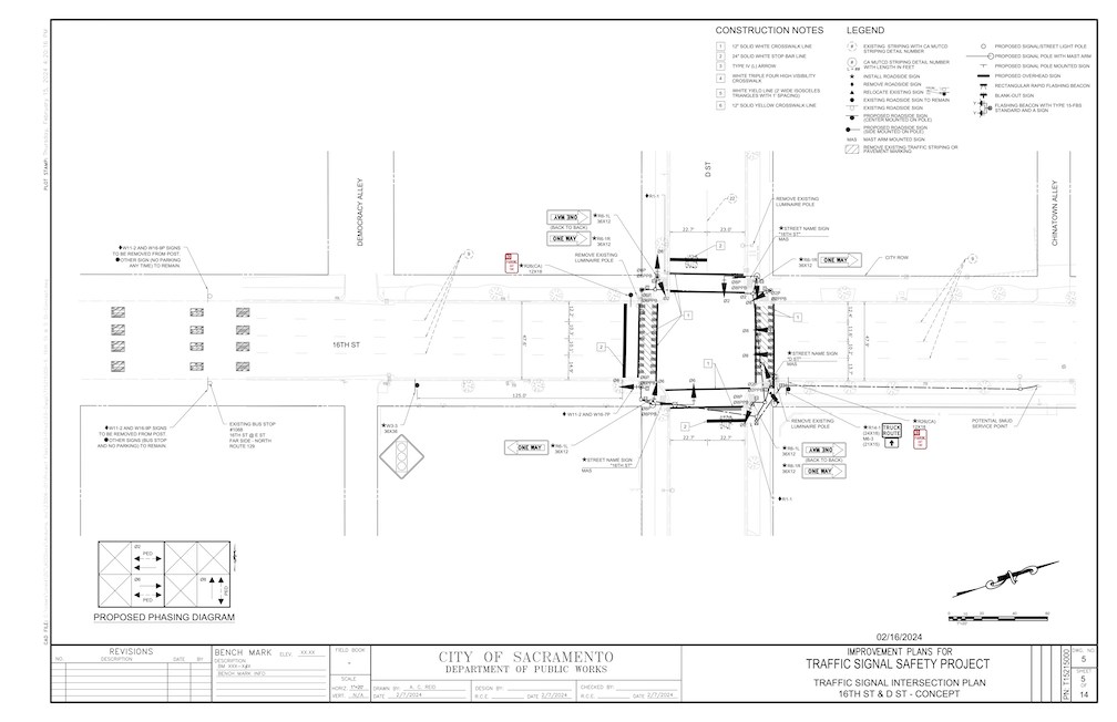
Agenda 3: Traffic Signal Safety Program. There was a staff presentation with a slide deck that was not available to the public (this is an ongoing problem, see below). Though the diagrams in the presentation were much more detailed than the ones in the staff report, they still left out a lot about the context of the intersection. What is it close to? Are there already a lot of walkers? How far is it to the next safe crossing? Is a traffic signal the best solution? It was clear from answers to commissioner questions that a lot of information was missing. Apparently this project is the result of a SACOG grant made to the city in 2017. Presumably there was a resulting document on the project, but that was not made available. The staff person said site selection was based on traffic warrants, but then exhibited a lack of knowledge about warrants. The question came up about whether the city could install a signal of any type that didn’t meet designs in the CA-MUTCD (California version of the federal Manual for Uniform Traffic Control Devices). The initial answer was no, but this was revised to yes, however a grant would be unlikely to be obtained that included non-MUTCD designs.

Overall, the entire traffic signal project is disappointing. The traffic engineering section of Public Works seems to have a very simple view of the world, to wit, a street with an unsafe design > a traffic signal. Changing the street design? Nah. Calming traffic to make the crossing safer? Nah. Shortening the crossing distance? Nah.

Traffic signals are expensive! Though no budget detail was provided, it is reasonable to assume from the overall $7.9M budget, which includes four full traffic signals, three pedestrian signals, and two RRFB (rectangular rapid flashing beacon) that full traffic signals cost about $1M each. That kind of money could fund a lot of traffic calming with lane reductions and curb extensions. Please take a look at my agenda post, and a comment from Sean Rogers that provides a much lower cost alternative for the Monroe Street and Latham Drive intersection.

Traffic signals do not necessarily create safer streets. Certainly, they don’t promote safety in between signals, as drivers accelerate to previous, often egregious, speeds as soon as the light turns green. With rampant red-light running, stop signs are probably much safer than signals. Though drivers also run stop signs, they do so at much slower speeds, whereas drivers running red lights often accelerate into the red light, ensuring the death of anyone in their path. If there are no gaps in traffic on a roadway, then it is necessary to create gaps with some sort of control, but a traffic signal is often the dumbest and most expensive way of doing that.

California has two years from the adoption of the federal MUTCD, which was December 2023, to either submit its own version, or the federal version will be the version for California.

The federal MUTCD (2023) has some interesting text (Section 4B.03 Alternatives to Traffic Control Signals): “Since road user delay and the frequency of some types of crashes are sometimes higher under traffic signal control than under STOP sign control, consideration should be given to providing alternatives to traffic control signals even if one or more of the signal warrants (see Chapter 4C) has been satisfied”, followed by 14 alternatives to traffic signals.

Section 4C.01 Studies and Factors for Justifying Traffic Control Signals provides a list of nine possible warrants to justify a traffic signal:

Warrant 1, Eight-Hour Vehicular Volume
Warrant 2, Four-Hour Vehicular Volume
Warrant 3, Peak Hour
Warrant 4, Pedestrian Volume
Warrant 5, School Crossing
Warrant 6, Coordinated Signal System
Warrant 7, Crash Experience
Warrant 8, Roadway Network
Warrant 9, Intersection Near a Grade Crossing

It is unknown which of, or any of, these were used to justify the signal locations. There are very detailed (and hard to understand) explanations of each of these warrant types.

My comments on the project, which I did not quite finish (two minutes is a short time), included:

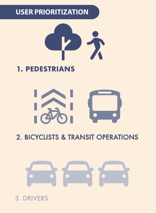
  • Signals are not necessarily a safety feature for people walking, unless there are no gaps in traffic, the more important issue is to calm traffic on the approaching streets
  • We already have a lot of unneeded signals, where the traffic volume and context of the intersection does not justify a full traffic signal, perhaps 60 of them just in the central city
  • 16th & D: traffic on 16th St needs to be calmed, signal will probably not shorten wait time for crossing
  • Rio Linda at Roanoke: lacks a connection to Sacramento Northern Trail, which would make it a great deal more useful, posted speed 40 mph is too high for an RRFB
  • Monroe and Latham: traffic calming through lane reduction and curb extensions would be as effective as a signal (Sean Rogers comment)
  • At about $1M for a full traffic signal, there are much less expensive alternatives, and much better ways of spending limited funds

Broadway Community Workshop

The City of Sacramento is hosting a workshop on Tuesday, April 23, on the Envision Broadway in Oak Park plan, and Vision Zero Broadway. The workshop will start 5:30PM at the Salvation Army Ray Richardson Community Center, 2540 Alhambra Boulevard, Sacramento, CA 95817.

The 2020 document Envision Broadway in Oak Park exists on the city website but is not findable as it transitions the website. There is no document, so far as I know on Vision Zero Broadway, other than that the section of Broadway east from 38th Street to Stockton Blvd is identified as a high injury corridor in the Vision Zero Action Plan.

The plan for the Alhambra Blvd to 38th Street section is very similar to that underway to the west under the Broadway Complete Streets project, and as such, has the same benefits and weaknesses. The diagram from the Envision document shows wide 15 foot sidewalks between Alhambra and 36th, but the sidewalks are mostly not wide, and what is shown is the entire sidewalk and sidewalk buffer.

The plan, as with the complete streets plan, ranks transportation modes:

  1. motor vehicles
  2. bicycles
  3. walking
  4. transit

The city’s General Plan 2040 has a different vision:

See a post on the Sacramento Transit Advocates and Riders (STAR) blog for more information: Envision Broadway in Oak Park.

SacATC April 18

The monthly meeting of the Sacramento Active Transportation Commission (SacATC) will be this Thursday, April 18, 2024, starting at 5:30 PM in the city council chambers. You can comment on these items, or on topics not on the agenda, ahead of time via eComment, or in person at the meeting. I encourage people to attend these commission meetings. There are usually very few members of the public in attendance, which means that your voice is important. Though eComments are valuable, in-person comments carry a lot more weight. The city’s planning staff is usually progressive and innovative, but Public Works in general is not, so it is important the citizens show up to push for progressive and innovative projects and policies. With some new appointments to the commission, and support of the public, the commission itself has been much more progressive than in past years.


The agenda includes three discussion items:

  1. Traffic Signal Safety Project
  2. Kastanis Way Shared Use Path
  3. Grand Avenue Sidewalk Infill

Kastanis Way Shared Use Path looks like a great project, connecting two dead-end streets for walkers and bicyclists, but not motor vehicles. These are the kinds of projects that should be implemented everywhere the opportunity exists.

diagram of Kastanis Way shared use path
Kastanis Way shared use path

Grand Avenue Sidewalk Infill also looks good, providing improvements to the crossing Grand Avenue by the Sacramento Northern multi-use path.

diagram of Grand Avenue Sidewalk Infill project
Grand Avenue Sidewalk Infill project

The Traffic Signal Safety project is questionable. There are nine locations:

  1. 16th Street at D Street (Traffic Signal)
  2. Franklin Boulevard at 36th Avenue (Traffic Signal)
  3. Freeport Boulevard at Kitchner Road (Traffic Signal)
  4. Fruitridge Road at 60th Street (Pedestrian Signal)
  5. Rio Linda Boulevard at Harris Avenue (Rectangular Rapid Flashing Beacon)
  6. Stockton Boulevard at 11th Avenue (Pedestrian Signal)
  7. 24th Street at 25th Street (Pedestrian Signal)
  8. Munroe Street at Latham Drive (Traffic Signal)
  9. Rio Linda Boulevard at Roanoke Avenue (Rectangular Rapid Flashing Beacon)

I haven’t had a chance to look at each of these proposals, though I will note that the city traffic engineers love to install traffic signals. At $100K to $500K per intersection, these are major investments. Many of the new signals the city has installed, for example on 5th Street and S Street, are unneeded, and waste of money. They have also converted a number of pedestrian signals from auto-recall (the pedestrian signal comes on at every signal cycle) to beg buttons (the person walking or rolling must activate the sensor, or the pedestrians signal will never come on). The city has a number of unnecessary signals, 60 in the central city alone. Maybe a one-for-one program is called for, install a new signal, take out an existing signal.

I don’t trust city traffic engineers. They label projects as safety projects for walkers and bicyclist, when they are really motor vehicle infrastructure projects. So-called pedestrian and bicyclist safety projects are often motor vehicle enhancements in disguise.

I cross 16th Street at D Street several times a week on bicycle, and occasionally walking, most often to access the American River bike trail via Sacramento Northern path over the river. Yes, I have to wait for a gap in traffic on 16th Street, which sometimes takes a while. But rarely longer than I would have to wait for a traffic signal, given that the arterial street (16th Street) always has a long green and the cross street (D Street) has a short green. I think that funds would be better spent slowing motor vehicle traffic on 16th Street, or adding bike facilities to 16th Street, or reducing the travel lanes on 16th Street, which is a four-lane traffic sewer. Traffic signals do not calm traffic. They irritate drivers, and cause them to quickly accelerate out of the signal to make up for time lost at the signal. They may allow for safer pedestrian crossing, or at least would if red light running were not an epidemic in Sacramento. The fact is, many drivers do not stop for red lights, and certainly don’t stop for people walking in crosswalks. Measures other than traffic signals are necessary to solve the issue.

diagram of traffic signal at 16th St & D St
traffic signal at 16th St & D St

The proposal for an RRFB (Rectangular Rapid Flashing Beacon) for Rio Linda Blvd at Roanoke Avenue is inappropriate. The posted speed limit in this section of Rio Linda Blvd is 40 mph, meaning that actual speeds are more like 50 mph. This is too fast for an RRFB to have any effect on drivers. Even at slower speeds drivers often ignore RRFBs. If there is to be a safe crossing at Roanoke, there must be a HAWK signal, or a full traffic signal. Again, funds would be better expended slowing traffic on Rio Linda. At this time, there is no connection between Roanoke Avenue and the Sacramento Northern Bike Trail, so it isn’t clear why this location has been picked for a signal.

diagram for RRFB for Rio Linda Blvd & Roanoke Ave
RRFB for Rio Linda Blvd & Roanoke Ave

I will leave it to others to examine the other seven locations. Are signals needed? Are they the right kind of signal for the context, particularly the speed and volume of motor vehicle traffic? Are there projects that would improve safety for walkers and bicyclists more than expensive traffic signals? Are these the best locations, the ones that best serve routes of travel for walkers and bicyclists? I have doubts that these questions were considered.

Note: Readers Sean Rogers has suggested a better, and less expensive, solution for Monroe and Latham, in comments. The solution may be calming traffic, not just installing a signal.

San Juan Rd at Airport Rd kills another person

I posted to Instagram about this, but it deserves amplification. “The Sacramento Bee had an article today that provided in-depth information about the death of a person crossing San Juan Rd in North Natomas. It included information about the dangerous roadway and lack of crosswalks and about the individual and family of the person killed. This is the kind of crash reporting we need to raise awareness and get the city to allocate resources to save lives.”

Apple Maps capture of intersection of San Juan Rd and Airport Rd in North Natomas, Sacramento
intersection of San Juan Rd and Airport Rd in North Natomas, Sacramento

I have worked off and on doing bicyclist education in North Natomas, and therefore crossed through this intersection many times, mostly bicycling but occasionally walking. It is not a safe intersection, for anyone.

Walking

The lack of crosswalks is obvious. The posted speed limit is 40 mph, but common practice and the design of the road sets that as a minimum rather than maximum. Knowing that this is a dangerous situation, the city has cross-hatched out the area from Azevado Drive to Airport Road on the north side, narrowing the roadway to one lane, but drivers routinely use this area for both travel and turning. Westbound drivers coming down off the overpass over I-80 accelerate to 60 mph. People walk across San Juan here. The city has decided to leave them to fate, and in this case the fate was death. A crosswalk without any additional protection would not be appropriate given the high speed traffic. It would require, at the least, a RRFB (rectangular rapid flashing beacon), which is a sign with flashing lights activated by the person wanting to cross. But given actual speed, it probably would need additional protection. Fixing poorly designed roadways is expensive, but so are lives.

There is a crosswalk over Airport Road, but given the wide-open design of the intersection, it is meaningless. Drivers turning from San Juan Road are unlikely to notice it. Drivers southbound on Airport Road generally stop over or beyond the crosswalk, because they need the visibility, and as much head start on the dangerous turn as possible. I know this from extensive observation.

Bicycling

Some people would say “but it has bike lanes”. Not really. Eastbound, motor vehicles turning onto Airport Road cross over the bike lanes at many points, regardless of any paint on the ground. If a person stayed in the bike lane, they would be exposing themselves to high speed traffic for along distance. Hug the curb to be further from motor vehicles, or use the bike lane so that you are more visible? It is a devils choice, forced by road design. West of Airport Road, the bike lane is missing for a distance, implying to drivers that they have the right-of-way over bicyclists. Eastbound, the bike lane is mostly continuous, except for the intersection itself (why?), but it is full of debris from construction traffic and car parts. To my knowledge, the city has never swept this bike lane.

It is difficult many times of the day to turn east from Airport Road to San Juan Road. High speed traffic, high volume at certain times, does not slow in the least in this area, and there is no signing to indicate they should.

Regular Class 2 bike lanes should be illegal on roadways posted over 35 mph. This road was mis-designed from the beginning. I don’t know whether the city later added bike lanes, though it is probably so given all the striping on San Juan to the east. The bike lanes did not make it safer for bicyclists.

Journalism

News media in general does a very poor job of reporting on traffic crashes, particularly when the victim is a walker or bicyclist. The initial news item parrots the law enforcement statement. Unless waiting for ‘notification of family’, the victim’s name is given, but the driver’s name never is. This is a strange inversion of ‘innocent until proven guilty’, making the driver innocent and the victim guilty. As I have stated many times before, law enforcement personnel have no training in analyzing the ways in which roadway design contributes, if not causes, traffic crashes. But they have a lot of ideas, not based in any research or training, that they are too happy to relay. One that will ring home with bicyclists is the repeated phrase ‘they weren’t wearing a helmet’, as though wearing a helmet protects against being hit by a driver traveling over the speed limit (they almost all are) or well over the speed limit, as is likely in this case.

A good summary of the issue is by SafeTREC, Media Narratives of Pedestrian and Bicyclist-Involved Crashes. If you want more, simply search the Internet for ‘poor journalism on traffic crashes’ or similar terms. Angie Schmitt wrote an entire book, Right-of-Way, about this issue and others. What about the next reporting? There usually isn’t any. The incident is never mentioned again. Law enforcement contributes to this by making sure that the incident report is delayed for weeks or months after the crash. In California, there is the common practice of law enforcement claiming that incident reports can never be released to anyone but immediate family. This is no backed up by state law, but it is common practice. So even when the incident report is completed, the public is unlikely to ever know the facts of the crash. All the public ever knows is the untrained, biased speculation of the law enforcement officer on the scene. The cynic in me can only see this as an intention on the part of law enforcement to protect drives and keep the public in the dark about traffic violence.

So, it was a wonderful breath of fresh air to read the Sacramento Bee article by Ariane Lange: A father died crossing a dangerous Sacramento road. His 13-year-old son was watching. The article went into depth about the person who was killed, and his family. It looked at the dangerous design of the road, and the fact that the city rarely fixes dangerous roads except with state or federal grants, not its own money. It talked about Vision Zero and the high injury network, of which San Juan Road is one, though in part due to problems further east. It talks about the statistics for death at various vehicle speeds, including 50% death at 40 mph (though it is very unlikely the driver was going that slow).

Traffic violence is pervasive in Sacramento, with the highest rate of fatal crashes in the state. The usual media reporting glosses over this, basically selling the story that if it wasn’t someone you know, it wasn’t that important. But it is always important, and sooner or later it will be someone you know, or you. These are real people with real lives, and real families and friends, and their death leaves a huge hole, whether they are homeless or not.

Thank you, Ariane, for telling the real story behind the death.

NACTO street designs

I started posting NACTO street design typologies, from the NACTO Urban Street Design Guide, to Instagram, but realized this was an inefficient way to promote these. So, these are the 13 designs, presented in a slide show, in the same order as the NACTO page.

Rather than rely on these thumbnails, though, I very much encourage you to look at the pages themselves, starting in the Streets section. The purpose of the designs is not primarily to show how streets might be designed from scratch, but how existing streets can be revised to be safer, more welcoming, and more economically productive. Several of the designs have before and after diagrams. Many of the diagrams have callout numbers linked to details that might not be immediately obvious. The illustrations are based on suggested roadway width and right-of-way width. All of the designs have background information and references to locales where they have been implemented.

The Strong SacTown Street Design Team has continued to work on street designs and classifications, and will propose a much simpler, probably four-part, design scheme. A simple classification will communicate clearly to planners and engineers, and the public. Nevertheless, it is educational to look at the full set of NACTO designs and giving thought to what kind of street you want to live on, and travel on. When the Strong SacTown designs are complete, I will link to them.

Land Park & Broadway construction zone issues

A new development is under construction on the southeast corner of Land Park Drive and Broadway, the historical site of Tower Records and Tower Books. I am glad to see development, particularly housing, happening here after the lot sitting empty for a bit more than a year. The project name is either Land Park & Broadway, or Tower Broadway. The project description from the City of Sacramento Agency Counter site is:

“MULTI-FAMILY HOUSING/MIX USE – New Five (5) story mixed use development consisting of ground floor retail within a concrete podium and (4) floors of for-rent apartments above. Studios: 39; 1 Bedrooms: 19; 2 Bedrooms: 10”

However, the construction site has several violations of ADA and PROWAG.

The crosswalk over Broadway at 16th Street is closed by a construction fence on the south side. However, there is no detectable warning barrier on the north side, only a sidewalk closed sign with, being on a folding barricade, is a trip hazard, and the pedestrians signal is not covered so that someone with limited vision would know the crosswalk is closed.

photo of Broadway at 16th St closed crosswalk not ADA compliant
Broadway at 16th St closed crosswalk not. ADA compliant

The same problem exists for the crosswalk over Land Park Drive, inappropriate signing posing a tripping hazard, lack of detectable barrier, and pedestrian signal face not covered.

photo of Land Park Dr at Broadway closed crosswalk, not ADA compliant
Land Park Dr at Broadway closed crosswalk, not ADA compliant

On the east side of Land Park Drive approaching the construction site, there is no detectable barrier, signing is placed so that it blocks access to the bus stop, and the construction fence intrudes into the sidewalk. Note that the pedestrian detour sign is not required and probably does nothing to help people walking.

photo of Land Park Dr closed sidewalk, not ADA compliant
Land Park Dr closed sidewalk, not ADA compliant

Getting a little closer, you can see that there is a bus stop for which access has been blocked by the construction signing. The bus stop is no longer accessible to anyone with mobility issues. I just talked to a SacRT employee, who said they had received no communication from either the city or the construction company about this blockage. SacRT will consider temporarily moving the bus stop. The construction company could have placed fencing and signing to maintain access to the stop, with a detectable barrier beyond the stop, but they did not. I suspect the city didn’t even notice this in their Traffic Control Plan. The city generally accepts whatever the construction company writes, without field checking it. It is well known that the city and most construction companies consider walkers and transit users as unimportant.

photo of Land Park Dr no bus stop access
Land Park Dr no bus stop access
Land Park Dr bus stop 1058

I did not check ADA compliance on the Broadway sidewalk approaching this construction site from the east, but would expect to see similar problems there.

While walking Broadway today, I noticed that two construction projects which were reported to the city (311) months ago have not been corrected. So far as I can tell, the city stopped inspecting or enforcing construction sites and Traffic Control Plans months ago.

SacATC March 21 notes

These are not intended to be, and are not, comprehensive, but rather, things that grabbed my attention.

Announcements

  • The city received a Reconnecting Old North Sacramento (Del Paso) grant through SACOG Green Means Go program. (https://www.sacog.org/Home/Components/News/News/117/)
  • At the city council meeting in which the SacATC Annual Report was discussed, Councilmember Venezuela directed staff to come back with a plan for a quick-build program, which will be developed over time
  • Ali Doeer-Westbrook relayed that Councilmember Vang requested that if the city is not going to act on a recommendation, they respond with reasons why; it is not clear how this will play out

Agenda 3 Streetcar (SacRT Anthony Adams presentation): went over the new proposal and alignment, and said this is phase 1, West Sac plans to extend way south; $160M project, with $130 secured so far, includes federal SmallStarts, construction 2027 if remainder of funding obtained; just submitted RAISE grant application and will submit state TIRCP grant; short segment on N will be shared sidewalk with bicycles, otherwise not, MAC asked for physical barrier on shared section, N Street will remain one way (per city direction, not converted to two-way), several of the slides presented were not in the agenda document but had additional detail

I commented on the 3rd St bike lane, it has only a narrow buffer, which is unacceptable adjacent to three high-speed traffic lanes, shared should be removed from 11-foot lanes and given to bike facilities; Matt Anderson talked about Class 2 bike lanes on the bridge (may be too narrow as well), which would be unsafe, and alternate routes; Deb Banks said the bike lanes could be raised to provide protection from motor vehicles

Agenda 4 Parks Plan: no public comment, David asked about parks designated as high need, which was not available tonight

Agenda 5 T-Street gap closure: this is a preliminary plan, but intended to fix issues with T Street rather than waiting for the Stockton Blvd reconstruction which is a ways off; presentation followed the agenda item document

My comments: good project, reduction 4 to 2 lanes under freeway is great, parking shown on 34th Street to 35th Street not needed; and removing it on the north side would allow a completely separated and protected bikeway for that block; most traffic turns right on Stockton, so right lane could be right turn only rather than pushing the merge onto T Street east of Stockton Blvd

Several people spoke in favor of a bike box for T Street at Stockton Blvd, but I’m not sure what exactly that means.

Agenda 6 ATP7, Jennifer Donlon Wyant presenting: She presented briefly on each of the projects; she said if the Freeport grant was approved, it would come back to the commission for design comment, which was a surprise as the agenda item did not indicate that; this guarantee seemed to make the commision comfortable enough that Freeport was included in the unanimous motion to recommend to council; when asked about priority of the three projects, Jennifer said they were not prioritized, but Northgate Blvd was highest on the Transportation Priorities Plan list

For items not on the agenda, I mentioned several items:

Rapid Response Program for SacCity

Note: This is a major revision of a post from 2024-01-31. The OakDOT Rapid Response Program is now in a separate post.

When a fatality or severe injury occurs for walkers and bicyclists, people often ask, what can we do right now to prevent or reduce the severity of the next crash? This topic has come up a number of times at the Sacramento Active Transportation Commission (SacATC), and communication from Slow Down Sacramento and the Safety ForumCivic ThreadSABA, Strong SacTown and other organizations.

Based on the successful program from Oakland, I am proposing that the City of Sacramento develop a similar rapid response program.

The City of Sacramento would establish a pilot Rapid Response Program with an initial budget of $100K. The pilot program would address only fatal crashes. The budget will likely be insufficient, as Sacramento has a state-leading level of fatal crashes, but the pilot would allow the city to develop expertise and program structure, and formulate a future budget. The city might respond only to fatal crashes on the high injury network, in order to extend the budget.

A Rapid Response Team will include a city planner and city traffic engineer, and may include responding law enforcement officer and walking or bicycling advocate (Civic Thread for walking and SABA for bicycling, paid for their time). I intentionally say the law enforcement officer who responded to the crash. Other law enforcement officers would likely offer only uninformed opinions and victim blaming, though the experience could be useful for educating officers about street design.

The team will review existing documents and data, and then visit the fatal crash site within two work days of the crash, or the death of a person resulting from an earlier crash.

The team will make a report within five working days which identifies and proposes quick-build features (countermeasures) to reduce or eliminate infrastructure hazards, with prioritization based on effectiveness.

The quick-build features (countermeasures) may include:

  • Refreshed crosswalk
  • Refreshed pavement markings
  • Temporary curb extension with flex posts
  • Temporary modal filter (traffic diverter) with flex posts
  • Temporary traffic circle with flex posts
  • New marked crosswalk
  • Changed or added signing
  • Temporary new stop sign; permanent stop sign would require additional analysis
  • Changed signal timing

At least one quick-build feature (countermeasure) will be installed within 10 work days of the site visit. Additional temporary features will be designed and scheduled.

I had previously mentioned mapping of crashes and related data by the city, because the state SWITRS system is always too far behind. I had previously mentioned a dashboard on crashes. However, these would probably best be implemented after the pilot year.

OakDOT Rapid Response Program

The City of Oakland Department of Transportation (OakDOT) Safe Streets Division has developed a Rapid Response Program to immediately address street infrastructure that contributes to fatal crashes.

The City of Oakland Department of Transportation (OakDOT) seems to have the best program I could find on the Internet. This is not surprising – since being formed in 2016, OakDOT has led on developing programs for safer streets that are informed by equity. Unfortunately, no single document on the program is available from OakDOT, but several presentations, case studies, and examples serve. Safe Oakland Streets (SOS) is Oakland’s version of Vision Zero.

Rapid Response Projects: OakDOT seeks to eliminate traffic fatalities and severe injuries while promoting safe, healthy, equitable mobility for all. OakDOT’s efforts to make streets safe include rapid responses to fatal and severe crashes involving the most vulnerable users of Oakland’s roadways. A Rapid Response is a coordinated effort in the days and weeks following a traffic tragedy that may include investigations, targeted maintenance, near-term improvements, and the identification and prioritization of longer-term capital needs.”

The two elements most relevant to rapid response are:

  1. Maintenance Treatment: If the crash location has a maintenance issue that may be related to traffic safety e.g., pavement defect, faded striping, missing sign), the maintenance issue will be rectified by field staff.
  2. Quick-Build Improvement: If there are design treatments that could be implemented quickly at low cost, engineering staff will prepare the design and issue a work order for field staff to construct.

A presentation to Oakland BPAC summarizes the program well and provides some examples.

Two examples are below, Harrison Street and the streets surrounding Garfield Elementary School.

OakDOT photo Harrison St & 23rd St showing quick build improvements resulting from Rapid Response
OakDOT graphic of safety improvements at Garfield Elementary School

OakDOT has a Crash Prevention Toolkit with photos of solutions, most of which are inexpensive and quick to implement.

OakDOT Crash Prevention Toolkit excerpt

OakDOT offers a map with locations of fatality crashes and relevant features such as high injury network and equity, Traffic Fatalities, City of Oakland. A chart, below, also shows yearly data for modes of travel. A Crash Analysis Infographic also communicates data visually.

OakDOT chart of traffic fatalities by mode over time

Elvas Ave and Hornet Tunnel

The section of Elvas Avenue between 62nd Street and Hornet Tunnel which leads to Sac State is very dangerous for bicyclists. Bicyclists have to transition across four lanes of traffic (three travel lanes and a center turn lane), without any protection whatsoever. The pavement quality is low, particularly on the east side where the ‘bike lane’ (not a real bike lane) is. Despite this, it is a high-use bicycle route from Sacramento to Sac State and the American River Parkway trail. M Street, this section of Elvas, and the Hornet Tunnel serve as a bicycle boulevard (though not designated) between the central city, Sac State, and beyond.

Since the day I arrived in Sacramento and rode my bike to work in the eastern suburbs, I have known that this section needs to be fixed. It took me 12 years to get around to writing about it. I hope that it will take the city less to fix it. The solution presented here is not the only solution, so I encourage others to comment, point out flaws, and suggest optimal solutions.

Elvas Avenue is a high-speed, moderately high-volume roadway that acts in many ways as an expressway due primarily to the turns from Elvas Avenue to 65th Street, and from 65th Street to Elvas that encourage high speeds. The roadway is dangerous for motor vehicle drivers and passengers as well as bicyclists. North of 62nd Street, St. Francis High School (about 1100 students) suffers from traffic risk created by Elvas Avenue, so traffic calming to the south will benefit the high school as well as bicyclists. It might be appropriate to extend the separated bikeway north to the signalized crosswalk over Elvas to the school.

Read More »