Walk Score update 2016-12

I’ve been curious about whether my Walk Score has changed with all the recent development in the area, since my earlier posts Walk Score (2012-03), Transit Score (2012-04), Bike Score (2012-05), and WalkScore update (2014-01). It has!

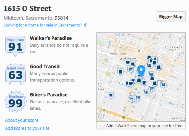
In March 2012, my Walk Score was 85: Very Walkable. In January 2014, my Walk Score was 82, Transit Score 62, and Bike Score 99. And today, my Walk Score is 91: Walker’s Paradise, Transit Score 63: Good Transit, and Bike Score 99: Biker’s Paradise. No big change in transit or bike, but a climb in walk score. And I am still tickled pink to be living where I do, in midtown Sacramento.

Quite a bit has changed on the Walk Score website over the years, and it is now much more focused on real estate. It has more in-depth information, but the algorithm is still proprietary. One of the beta features is a crime score, and my neighborhood ranks as a B.

walkscore_2016-12

WalkScore update

SacWalkScore43
SacTransitScore33
SacBikeScore68

WalkScore has released for Sacramento a new walk score, 43, transit score, 33, and bike score, 68. New York is the top walk score city at 92, followed by San Francisco, Boston, Philadelphia and Miami. New York is the top transit score city at 81, followed by Boston, San Francisco, Washington DC, and Philadelphia. Portland is the top bike score city at 70, followed by San Francisco, Denver, Philadelphia and Boston. Sacramento compares very well in bike score, at 68, but poorly in walk score and transit score.

For the Sacramento region, walk scores in various neighborhoods range from 5 to 92 (of 100), transit scores range from 11 to 65, and bike scores range from 38 to 100. In general, the scores track with each other, walk friendly = transit friendly = bike friendly, however, there are exceptions. You can look up your neighborhood on the chart linked below, or go to WalkScore for a lot more detail on Sacramento. The top five neighborhoods are Boulevard Park, Downtown, Midtown/Winn Park/Capital Avenue, Marshall School and Mansions Flats, all in the city of Sacramento. WalkScore exists largely as a sales tool for houses and apartments, but it has broad applicability as well.

SacramentoNeighborhoodsWalkScore

Reference: The top 10 US cities for public transportation (Kaid Benfield, NRDC Switchboard, 2014-01-28)

And, I’m happy to report that where I live, on the border between Midtown and Downtown is:

MyWalkScore82MyTransitScore62MyBikeScore99
And that’s why I live here!

arena or not…

arena arial, from City of Sacramento

Whether the arena is built or not, I care little, and whether the Kings stay or not, I care not at all. But what I find interesting is that no one any longer talks about a public asset like this being located in the suburbs. When it was in the railyards, it was a downtown arena. As it is now proposed on the footprint of the mall, it is the downtown arena. It is the same in Seattle, where the arena location is not so central but is still part of downtown.

Sacramento has grown up! It realizes that downtown is the place for public assets. Downtown has a high density of public transit, walkable and bikeable areas, a grid street pattern, established businesses that can serve patrons of an events center, and yes, even freeways.

The ARCO/Power Balance/Sleep Train facility squats in the middle of acres of parking, a 12,000 parking space wasteland. It is far from light rail, is poorly served by bus (you can get there, but you can’t get home, for evening events, and not at all on Sunday, transit score 24, minimal), is in an un-walkable and un-bikeable area (all high speed arterial roads, walk score 48, car dependent), where almost no streets go through (the classic suburban street system of cul-de-sacs and streets that wind interminably). Why anyone ever thought an arena in Natomas was a good idea, I don’t know, but at least no one any longer thinks it is. And that is progress!

Downtown Plaza, the currently proposed location, has a walk score of 94, walker’s paradise, and a transit score of 67, good transit.

Bike Score

Bike Score for Minneapolis, with “heat map”

The next stage from the folks at Walk Score, Bike Score, is now available, for a select 10 cities. There aren’t any big surprises, Minneapolis, San Francisco, and Madison are at the top.

Sacramento is not on the list of 10. If you’d like to see it there, you can go to the Bike Score page and tweet a vote for it. Please do!

Walk Score also recently released Transit Score, where Sacramento is listed, as 22 out of the 25 largest cities with accessible transit data, at a score of 32. Both the Bike Score and Transit Score are created at a city-wide level, unlike the address-specific Walk Score. So these rankings are just first steps, but nevertheless interesting and useful.

You may have seen articles in the media recently about the high correlation between walkability and housing prices, with walkable communities in high demand and unworkable suburbs in the doldrums. This is good news for all of us. Walk Score was in fact designed as a tool for helping people find real estate and apartments in places that fit their desired lifestyle. As the correlation between walkable, bikeable, transit-dense communities and livability becomes more clear, resources (societal and personal) will be shifted away from the suburbs to urban areas.

Transit Score

I previously wrote about Walk Score and its use in Sacramento, and now the Walk Score company has released Transit Score. Sacramento ranks 22 out of 25 cities, with a Transit Score of 32 (of 100), in the category of “some transit.” The categories are rider’s paradise, excellent transit, good transit, some transit, and minimal transit. It is worth noting that if all the major cities had provided their transit information, Sacramento would probably have not been on the list at all, because with a population of just under a half million, it is not in the usual top 25 but would show up in a top 50.

Walk Score notes “The Transit Score algorithm calculates a score for a specific point by summing the relative ‘usefulness’ of nearby routes. We define usefulness as the distance to the nearest stop on the route, the frequency of the route, and type of route.” As pointed out in the recent Streetsblog post, it does not including information about where you can go once you’ve gotten onto the transit, which also of course affects the usefulness of the transit.Read More »